Within the upper Bowron River watershed study area, twenty two RVTs were identified at the Watershed Level. The general priority rating for field assessment, the RVTs and codes used in the database, are presented in Table 1 and in Appendix B. The following results describe the overall riparian habitat condition and consequently describes areas impacted, not only by logging, but also those areas affected by mining activity and roads.
Code RVT Label Description
Low Priority
3 MFc/S Mature coniferous forest dominated by Engelmann spruce
6 MFc/Pl Mature coniferous forest dominated by lodgepole pine
2 MFc/BS Mature coniferous forest dominated by sub-alpine fir and Engelmann spruce
1 MFc/PlS Mature coniferous forest dominated by lodgepole pine and Engelmann spruce
18 MFd/Ac Mature deciduous forest dominated by cottonwood
20 MFm/PlAt Mature mixed forest dominated by lodgepole pine and trembling aspen
19 YFc/PlS Young coniferous forest dominated by lodgepole pine and Engelmann spruce
4 MFc+PSc/BS Mature coniferous forest and pole sapling coniferous forest of sub- alpine fir and Engelmann spruce as a result of herring bone logging
Medium Priority
8 PSc/SB Pole sapling coniferous forest of Engelmann spruce and sub-alpine fir
9 SHts/Pl Tall shrubs dominated by lodgepole pine
10 SHts/S Tall shrubs dominated by Engelmann spruce
12 SHts/PlS Tall shrubs dominated by lodgepole pine and Engelmann spruce
15 SHts/SB Tall shrubs dominated by Engelmann spruce and sub-alpine fir
7 SHts/PlB Tall shrubs dominated by lodgepole pine and sub-alpine fir
17 SHts/PlAt Tall shrubs dominated by lodgepole pine and trembling aspen
High Priority
21 SHls/Pl Low shrubs dominated by lodgepole pine
14 SHls/SB Low shrubs dominated by Engelmann spruce and balsam fir
13 SHls/SPl Low shrubs dominated by Engelmann spruce and lodgepole pine
22 SHls/ Low shrubs cominated by lodgepole pine, trembling aspen and Englemann spruce
Highest Priority
11 SHls/M Low shrubs dominated by maple
16 NSsp Non-vegetated-sparse with less than 10% vegetation cover
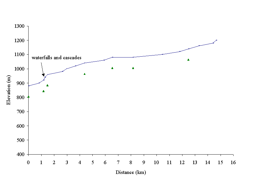
Figure 4. Towkuh Creek drains an area of 37.8 km2 as it flows east into the Bowron River. Fish distribution is based on the Overview FHAP assessment.
 Towkuh Creek (100-6570-715)
drains an area of 37.8 km2 and has a mainstem length of approximately
17km from its headwaters to its mouth at the confluence with the Bowron River
(Figure 4). Its seven reaches are delineated in the gradient profile (Figure
5). The profile is based on reach breaks provided by the reconnaissance fish
inventory of Ketcham and Towkuh creeks (Carmanah, 1997b) The elevation ranges
from 900m at the Bowron River confluence to 1500m in its headwaters. The watershed
is located within the Engelmann Spruce Subalpine Fir (ESSF) and Sub-Boreal
Spruce (SBS) biogeoclimatic zones. Towkuh Creek lies within a V shaped valley,
on the edge of the Palmer Range, in the Quesnel Highlands of the Interior
Plateau. Towkuh Creek is controlled by a 12 m set of waterfalls and cascades
with over 30% gradient located 1500 m from its confluence with the upper Bowron
River.
Towkuh Creek (100-6570-715)
drains an area of 37.8 km2 and has a mainstem length of approximately
17km from its headwaters to its mouth at the confluence with the Bowron River
(Figure 4). Its seven reaches are delineated in the gradient profile (Figure
5). The profile is based on reach breaks provided by the reconnaissance fish
inventory of Ketcham and Towkuh creeks (Carmanah, 1997b) The elevation ranges
from 900m at the Bowron River confluence to 1500m in its headwaters. The watershed
is located within the Engelmann Spruce Subalpine Fir (ESSF) and Sub-Boreal
Spruce (SBS) biogeoclimatic zones. Towkuh Creek lies within a V shaped valley,
on the edge of the Palmer Range, in the Quesnel Highlands of the Interior
Plateau. Towkuh Creek is controlled by a 12 m set of waterfalls and cascades
with over 30% gradient located 1500 m from its confluence with the upper Bowron
River.
Figure 5. Gradient profile of Towkuh Creek with seven reaches delineated by triangles
Extensive harvesting has occurred within the Towkuh Creek sub-basin as a result of beetle salvage operations which occurred in the mid 1980s. Harvesting has taken place along the entire length of Towkuh Creek. Riparian buffer strips have been maintained in some areas, however, clearcuts abut the creek edge in several locations. Towkuh Creek has an ECA of 52% with much of this activity being concentrated from the confluence with Bowron River to Towkuh Lake. Riparian segments and the corresponding RVTs are presented in Appendix B.
Reach 1
Riparian vegetation has been removed through forest harvesting activities on the left (north) stream bank. Segments 54, 55 and 56 are classified as not satisfactorily restocked (based on Forest Cover Map lables). Segment 55 has evidence of exposed mineral soils. Chinook are known to use this reach as a rearing area and spawning is suspected. Fish habitat is likely being impacted by impairments to stream shading, LWD, SOD and channel stability. Sediment and nutrient filtering functions are also suspected of being impaired. Segments 54, 55 and 56 are recommended as high priority for Level 1 riparian assessments.
Reaches 2-7
The upper reaches of Towkuh Creek are classified as S5 and do not directly support fish populations. Harvesting has occurred in the area surrounding the creek, but not within the RMA. The riparian areas are dominated with mature spruce and lodgepole pine which was maintained at the time of harvesting. No recommendations for site level assessments have been made for these reaches. Riparian vegetation is intact and riparian function in not thought to be impaired.
Priority Segments for Site Level Assessments
Table 2 identifies segments where riparian function has been lost or impaired and prioritizes these segments for site level assessments. Refer to Site Level Riparian Assessment maps for priority site locations.
Table 2. Priority Riparian Segments in Towkuh Creek
|
Sub-basin name |
Reach # |
Stream Classi- fication |
Seg-ment #. |
Segment Length (km) |
Riparian Vegeta- tion Types |
Riparian Function impairments (based on Table B4 of Appendix B) |
Priority rating for site level riparian assessments |
|
Towkuh Creek |
1 |
S2 |
54 |
0.24 |
SHls |
stream shading,LWD, channel stability, sediment filtering, nutrient filtering |
High |
|
Towkuh Creek |
1 |
S2 |
55 |
0.88 |
SHls |
stream shading,LWD, channel stability, sediment filtering, nutrient filtering |
High |
|
Towkuh Creek |
1 |
S2 |
56 |
0.20 |
SHls |
stream shading,LWD, channel stability, sediment filtering, nutrient filtering |
High |
4.2 Ketcham and West Creek Sub-basins
West Creek flows north into the Bowron River and has a mainstem length of approximately ten kilometers (Figure 6 ). Seven reaches were delineated in the gradient profile (Figure 7). Ketcham Creek, a main tributary of West Creek, flows east into West Creek three km upstream from the Bowron River and West Creek confluence. The main channel of Ketcham Creek has a length of 30km with ten reaches delineated in the gradient profile (Figure 7 ). The profile is based on reach breaks provided by the reconnaissance fish inventory of Ketcham and Towkuh creeks (Carmanah, 1997b). The elevation increases from 900m at the Bowron River to 3900m in its headwaters. Both sub-basins are located within the ESSF and SBS biogeoclimatic zones and drain a combined area of 126km2.
Figure 7 . Gradient profile of West Creek with seven reaches delineated by triangles.
West Creek Riparian Habitat Condition
Reach 1
Reach 1 of West Creek is largely a continuation of Ketcham Creek and is likely misnamed. The reach flows from its confluence with Ketcham through mature conifer forests into Lower Summit Creek before entering the Bowron River mainstem. Harvesting has occurred in some areas surrounding the creek, however, no harvesting has occurred within the RMA. The main impact within the RMAs is from a road which runs along the stream channel in several locations.
Reach 2
In Reach 2, Segment 12 is recommended for Site Level Assessment. The outer 25% of the left RMA is NSR and dominated by shrub stage vegetation while the right RMA is dominated by coniferous pole saplings stage spruce and balsam.
Reach 3
In Reach 3, segment 10 has a secondary road and log landing with exposed mineral soils through most of the outside portion of the right RMA. It is also recommended for site assessments.
Reach 4
The majority of the riparian vegetation communities within the RMAs along this reach are a mixture of mature conifer forests and coniferous pole saplings forests. No riparian concerns were identified within this segment.
Unnamed Creek 100-6570-750-608-419 flows into West Creek at reach break 5. Most of its riparian area consists of mature coniferous forest with evidence of ‘herring-bone’ logging.
Reaches 5-6
Reaches 5 and 6 of West Creek do not contain any fish species. Water flows and habitat availability is rated as low in these reaches. No forest harvesting activities were identified within these reaches.
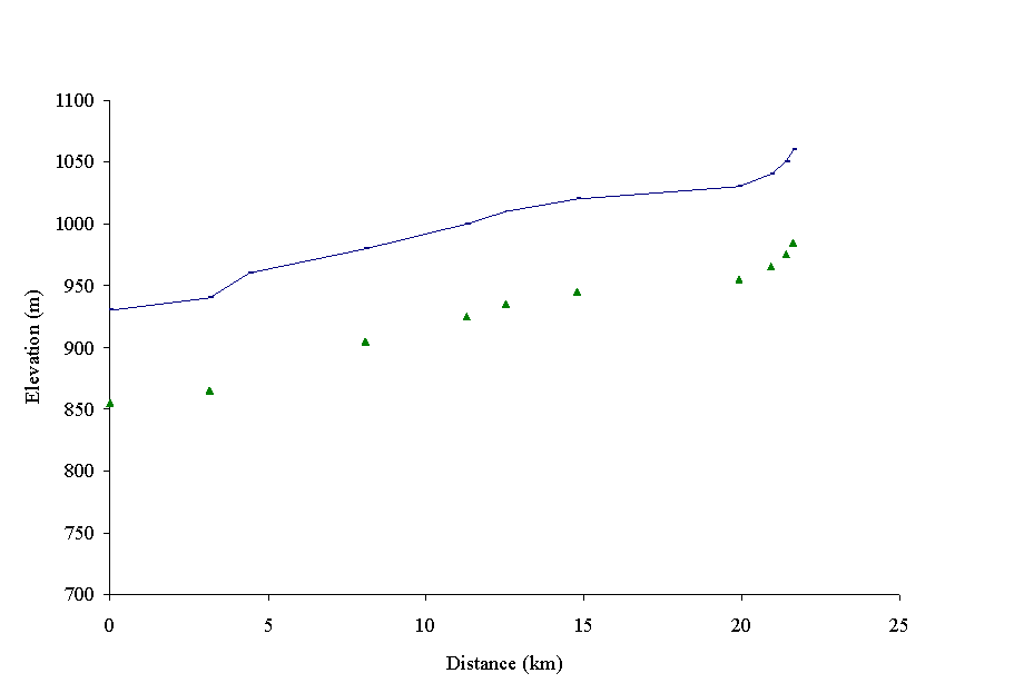
Figure 8. Gradient profile of Ketcham Creek with ten reaches delineated by triangles.
Ketcham Creek consists of ten reaches, nine of which are characterised by very low gradient meandering stream channels that wind through extensive floodplain. Reach 1 is a higher gradient reach that consists of pool-riffle habitats that chinook are known to use for spawning (Carmanah, 1997b). The meandering channel typical of the majority of Ketcham Creek begins in reach 2 and extends to the upper reaches of the sub-basin.
Ketcham Creek is one of the most heavily logged drainages in the Bowron Watershed, with an ECA of 42% (Bowron Watershed Committee, 1997b). Forest harvesting activities have taken place throughout both sub-basins, along the mainstems and tributaries.
Ketcham Creek Riparian Habitat Condition
Riparian segments and the corresponding RVTs are presented in Appendix B.
Reach 1
The upper 1700m of reach 1 was harvested in 1976. This reach has an S2 stream classification (FPC, 1995). This reach provides important fish habitat as spawning Chinook salmon have been identified in this harvested section (Carmanah, 1997. Draft Overview FHAP). Segments 45 through 49 have the highest priority for Site Level assessments, as they include NSR areas. Stream shading, LWD, and SOD functions are suspected of being impaired.
Reach 2-10
Channel meandering begins in reach 2 and continues through to reach 10. The creek flows through a wetland which has an average width of 200m, bordered by mature coniferous forests of spruce, lodgepole pine and balsam. No forest harvesting activities have been identified within the RMA of these reaches, and no recommendations for site level assessments have been made as riparian function does not appear to be impaired.
Ketcham Creek Tributaries
Extensive harvesting has occurred along several tributaries of Ketcham Creek. Most affected are Ketcham Locational Point (KELP) 12, KELP 13 and KELP 17. KELP 12 and KELP 13, both S3 streams (FPC classification), have undergone extensive logging within their RMAs. RMAs in segment 101 in KELP 12, and 104 and 105 in KELP 13 are classified as NSR (based on forest cover/ inventory information). Large areas of exposed mineral soils, as well as roads and landings exist throughout. Riparian functions such as LWD, SOD, stream shading and bank stability are suspected of being impaired due to harvesting activities. Site assessments are given high priority for these areas. RMAs in segments 85, 86, 87 and 88 of KELP 17, an S3 stream have been completely logged and are classified as NSR.
Unnamed Creek 100-6570-750-300-687, which has a FPC stream classification of S3, has been clear-cut logged to the stream bank on both sides. This has caused severe impacts to RMA ecological function. The RMAs along segment 12 are comprised of low shrub structural stage vegetation dominated by spruce and balsam regeneration. This site has been given a high priority for site assessments. Segments 109, 110 and 111 have also been recommended for Level 1 assessments as the riparian vegetation at these sites have also been harvested. Harvesting occurred in 1985 and current riparian vegetation consists of shrub species and conifer regeneration.
Priority Segments for Site Level Assessments
Tables 3 and 4 identify segments where riparian function has been lost or impaired and prioritizes these segments for site level assessments. Refer to Site Level Riparian Assessment maps for priority site locations.
Table 3. High Priority Riparian Segments in Ketcham Creek Sub-basin
|
Sub-basin name |
Reach # |
Stream Classi- fication |
Seg-ment # |
Segment Length (km) |
Riparian Vegetation Types |
Riparian Function impairments (based on Table B4 of Appendix B) |
Priority rating for site level riparian assessments |
|
Ketcham Creek |
1 |
S2 |
45 |
0.74 |
SHls/Pl |
stream shading,LWD, channel stability, sediment filtering, nutrient filtering |
High |
|
Ketcham Creek |
1 |
S2 |
47 |
0.37 |
SHts/PlSx |
stream shading,LWD, channel stability, sediment filtering, nutrient filtering |
High |
|
Ketcham Creek |
1 |
S2 |
48 |
0.19 |
SHts/PlSx |
stream shading,LWD, channel stability, sediment filtering, nutrient filtering |
High |
|
Ketcham Creek |
1 |
S2 |
49 |
0.71 |
SHls |
stream shading,LWD, channel stability, sediment filtering, nutrient filtering |
High |
|
Un-named Creek (KELP 17) |
1 |
S3 |
85 |
0.35 |
SHls |
stream shading,LWD, channel stability, sediment filtering, nutrient filtering |
High |
|
Un-named Creek (KELP 17) |
1 |
S3 |
86 |
0.34 |
SHls |
stream shading,LWD, channel stability, sediment filtering, nutrient filtering |
High |
|
Un-named Creek (KELP 17) |
1 |
S3 |
87 |
0.43 |
SHls |
stream shading,LWD, channel stability, sediment filtering, nutrient filtering |
High |
|
KELP 17 |
1 |
S3 |
88 |
0.26 |
SHls |
stream shading,LWD, channel stability, sediment filtering, nutrient filtering |
High |
|
KELP 12 |
1 |
S3 |
101 |
0.69 |
NSsp |
stream shading,LWD, SOD,channel stability, sediment filtering, nutrient filtering |
High |
|
KELP 13 |
1 |
S3 |
104 |
0.16 |
SHls |
stream shading,LWD, channel stability, sediment filtering, nutrient filtering |
High |
|
KELP 13 |
2 |
S3 |
105 |
0.52 |
SHls/Pl |
stream shading,LWD, channel stability, sediment filtering, nutrient filtering |
High |
|
100-6570-750-300-687 |
3 |
S3 |
112 |
2.60 |
SHls/PlAtSx |
stream shading,LWD, channel stability, sediment filtering, nutrient filtering |
High |
Table 4. Lower priority recommendations for Site Level Riparian Assessment.
|
Sub-basin name |
Reach # |
Stream Classi- fication |
Seg-ment # |
Segment Length (km) |
Riparian Vegetation Types |
Riparian Function impairments (based on Table B4 of Appendix B) |
Priority rating for site level riparian assessments |
|||||||
|
West Creek |
4 |
S3 |
6 |
0.29 |
MFc PSc/SxBl |
LWD, channel stability, SOD,nutrient filtering |
Medium |
|||||||
|
West Creek |
4 |
S3 |
7 |
0.39 |
MFc PSc/SxBl |
LWD, channel stability, SOD,nutrient filtering |
Medium |
|||||||
|
West Creek |
3 |
S3 |
10 |
0.53 |
PSc/SxBl |
LWD, SOD, channel stability, nutient filtering |
Medium |
|||||||
|
West Creek |
2 |
S3 |
12 |
0.15 |
SHls |
stream shading,LWD, channel stability, sediment filtering, nutrient filtering |
Medium |
|||||||
|
Ket-chum Creek |
2 |
S2 |
51 |
1.41 |
SHts/Pl |
stream shading,LWD, channel stability, sediment filtering, nutrient filtering |
Low |
|||||||
|
100-6570-750-300-687 |
1 |
S3 |
109 |
0.28 |
SHts/Pl |
stream shading,LWD, channel stability, sediment filtering, nutrient filtering |
Low |
|||||||
|
100-6570-750-300-687 |
2 |
S3 |
110 |
0.47 |
SHls/PlAtSx |
stream shading,LWD, channel stability, sediment filtering, nutrient filtering |
Low |
|||||||
|
100-6570-750-300-687 |
2 |
S3 |
111 |
0.47 |
SHls/Pl |
stream shading,LWD, channel stability, sediment filtering, nutrient filtering |
Low |
|||||||
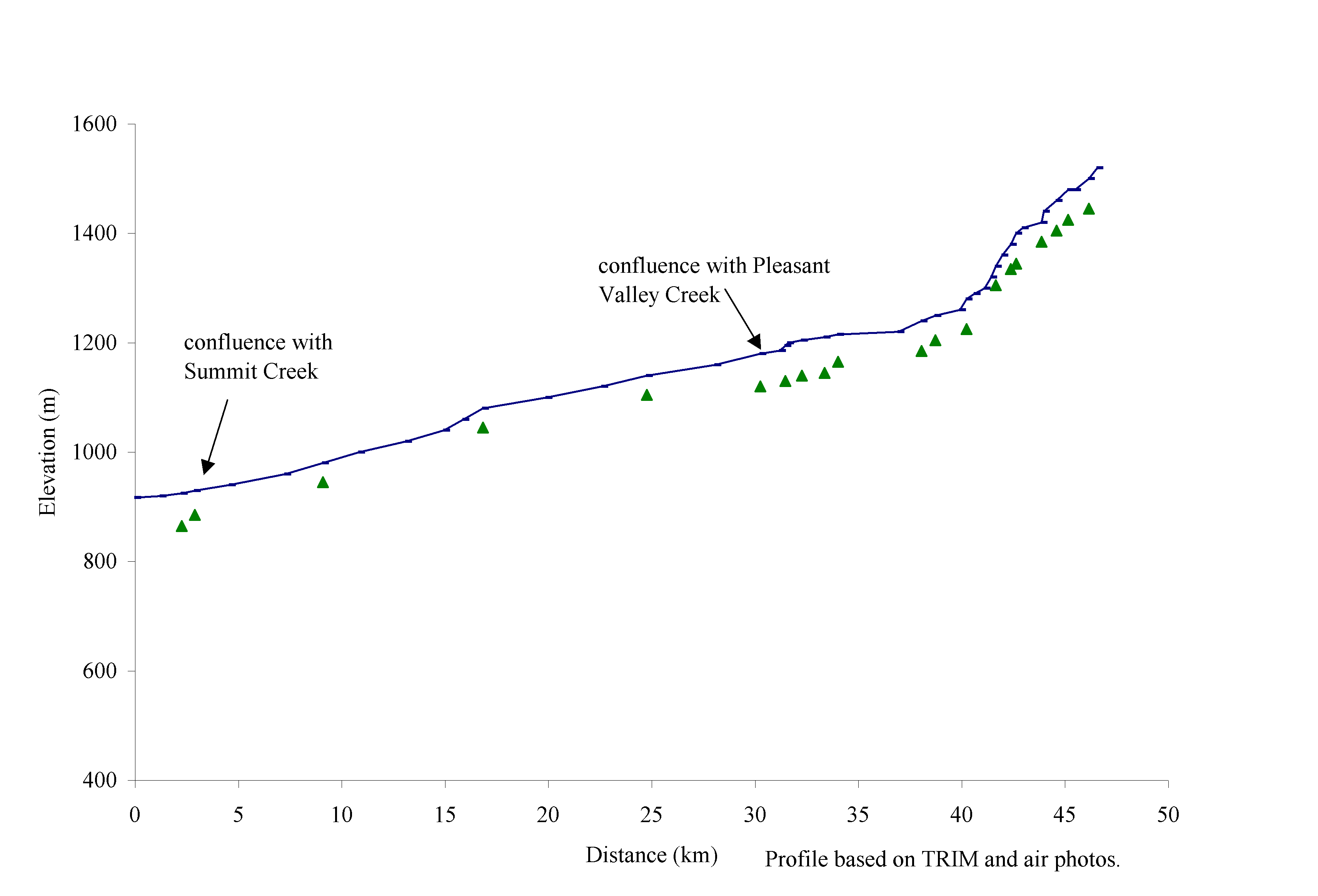
Antler Creek is a fourth order stream located within West Fraser Mills Tree Farm License 52, approximately 7 km east of the town of Barkerville, B.C. (Figure 9). The Antler Creek sub-basin is the fourth largest sub-basin in the upper Bowron River watershed behind the Haggen, Bowron residual and Indian Point sub-basins. The watershed drains north parallel to the Bowron Lakes Provincial Park, from its headwaters at Race Track Creek to its mouth, approximately 33 km downstream, at the Bowron River confluence. Reaches 1 and 2 of the Antler mainstem flow directly through the north western end of Bowron Lake Provincial Park and the associated private lands of Bowron Lodge. The elevation ranges from 900m at the Bowron River confluence to 1220m in its head waters at Race Track Creek.
 The
watershed is located within the ESSF and SBS biogeoclimatic zones. Antler
Creek lies within a steep V shaped valley, on the edge of the Palmer Range,
in the Quesnel Highlands of the Interior Plateau, and drains 359 square kilometres
(Figure 10). Underlying surficial material in the watershed consist of Palaeozoic
glacial tills. Antler Creek has seven main tributaries and many small 1st
and 2nd order tributaries, which are all confined within steep sided valleys.
The
watershed is located within the ESSF and SBS biogeoclimatic zones. Antler
Creek lies within a steep V shaped valley, on the edge of the Palmer Range,
in the Quesnel Highlands of the Interior Plateau, and drains 359 square kilometres
(Figure 10). Underlying surficial material in the watershed consist of Palaeozoic
glacial tills. Antler Creek has seven main tributaries and many small 1st
and 2nd order tributaries, which are all confined within steep sided valleys.
Figure 10. Gradient profile of Antler Creek with 20 reaches delineated by triangles.
The Antler Creek sub-basin was subjected to extensive mining activity in the mid-1800s associated with the Cariboo Gold Rush. Several placer mining operations within the watershed are currently active. Placer mining along the Antler Creek mainstem and its tributaries, combined with associated site and forest clearing have had significant impacts on the watershed (Bowron Watershed Committee 1997).
The upper Bowron River Level 1 IWAP indicated that forestry associated impacts on the watershed are low (Bowron Watershed Committee, 1997). The overall Equivalent Clearcut Area (ECA) for Antler Creek is 8%. The Bowron Watershed Committee (1997) also described the level of hydraulic concern related to forest harvesting as low. Historic forest harvesting has been concentrated in the lower reaches of the Antler and Summit Creeks. Stream side harvesting has occurred along the Antler mainstem floodplain terrace along reaches 1-3 between 1956-1970; this includes the mouth of Summit Creek. Reaches 1 and 5 of Summit creek have been harvested.
Antler Creek Mainstem Riparian Habitat Condition
Riparian segments and the corresponding RVTs are presented in Appendix B.
Reaches 1 and 2
The lower portion of reach 1 flows through the private lands of Bowron Lodge. The stream flows for 400 meters through a man-made channel and agricultural lands bordered by grass and some shrubs. Segment 120, which includes this area, has an RMA that has lost all ecological riparian function. In reach 2 the RMA on the left side of the stream channel is classified as NSR.
Reach 3
Most of the RMA in reach 3 was logged between 1957 and 1970. Segment 126 is curently classified as NSR and is vegetated primarily with conifer regeneration and abundant shrubs. Riparian functions within this segment which are suspected of being impaired include stream shading, channel stability and LWD.
Reaches 4 and 5
Reaches 4 and 5 have relatively straight channels bordered by a canyon with several natural bank failures. These bank failures are providing substantial sediment to the main channel. The majority of the riparian vegetation communities are composed of mature lodgepole pine and spruce forests with smaller sections of shrubs. Along reach 5, there are several areas with exposed soils that are associated with mining development. Vegetation within these areas is sparse.
Reach 6
Antler Creek is contained within a wide floodplain that narrows and becomes increasingly confined as it nears the canyon typical of reach 5. Throughout most of this reach it is bordered by a large W1 wetland (50 ha). This reach is bound at its upper end by the confluence of Pleasant Valley and Grouse Creeks. Major impacts in this reach are from road building and placer mining activity. Mature spruce, balsam and pine forests dominate the vegetation within the RMAs.
Reaches 7-10
RMAs in reaches 7-10 are dominated by mature spruce and lodgepole pine forests.The 3100 road parallels these reaches. In segment 295, mining or road building related activities have resulted in a sparsely vegetated RMA on the right side of the stream channel.
Reach 11
Reach 11 spans Cunnigham Pass with the creek flowing through a W1 wetland (51 ha). The major impacts are related to placer mining activities within the RMAs, which have resulted in extensive areas of exposed mineral soils and tailings piles. Segments 288 and 290 have particularly significant impacts.
Reaches 12-14
Throughout these reaches placer mining activities have significantly impaired riparian function by producing large areas of exposed mineral soils and tailings piles throughout the RMA on both sides of the stream. Riparian vegetation communities are dominated mainly by mature spruce and balsam forests.
Reaches 15-20
Placer mining activity has occurred throughout much of this area, but to a much lesser extent than lower reaches. RMA vegetation communities are composed primarily of mature spruce and balsam forests.
Antler Creek Tributaries
The following tributaries have RMAs that have been significantly impacted by harvesting and mining activities.
Summit Creek
Summit Creek is a third order stream that drains into Reach 3 of Antler Creek, approximately 2.8km upstream of the confluence of Antler Creek and Bowron River. The gradient profile delineates nine reaches (Figure 11) and is based on the fish inventory of Antler Creek (Carmanah, 1997a, Figure 9). The creek is characterised by confined channels in steep canyons interspersed with meandering low gradient wetland reaches. Historic logging has occurred in the early 1980s on the raised terrace above the channel valley walls. Forest regeneration in these harvested areas is advanced. Potential fish habitat impacts are associated primarily with placer mining activities.
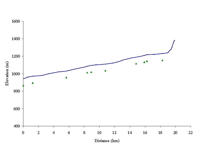
Figure 11. Gradient profile of Summit Creek with nine reaches delineated by triangles.
Reach 1
The lower portion of Reach 1 was harvested in 1969-1970 and is currently classified as NSR. This stream segment is suspected of being a rearing area for Chinook and has been recommended for a Level 1 FHAP. This low shrub RMA has lost stream shading, large woody debris and channel stability functions; sediment and nutrient filtering capabilities are suspected of being impaired. This area is recommended for site assessments due to the suspected losses in LWD, shading and bank stability functions, and because of its importance as a fish habitat.
Reach 2
Reach 2 is confined within steep valley walls with several large natural landslides. The degree to which these slides have been initiated by hydrological changes created by a 1977 cutblock above the slides is unknown. Segment 138 has a left bank RMA that is sparsely vegetated because of the slides.
Reaches 3 and 4
Logging activity has not significantly effected the RMAs in these reaches. Several smaller areas of exposed mineral soils are likely due to placer mining. No segments are recommended for Site Level Riparian Assessment.
Reach 5
Reach 5 is characterised by a low gradient segment with a wetland bordering the stream channel. The RMAs within this reach were harvested in 1957. Segments 157, 158 and 159 have a secondary road and 2 landings within the RMA on the south side of the creek. Riparian vegetation communities within this site are composed mostly of young conifer forests, with smaller areas of shrub vegetation. This site is recommended for site assessments.
Reaches 6-9
Reach 6 is a confined channel with mature spruce, lodgepole pine, and balsam forests within the RMAs; the upper portion of the reach borders a wetland complex immediately below reach 7. An active placer mining operation is located along reaches 7 and 8. Bank destabilization and removal of riparian vegetation as a result of these mining activities have impacted rainbow trout habitat. Riparian function is severely impaired and this site is a high priority for site level assessments.
Murray Creek
Murray Creek flows into Antler Creek at the upper boundary of reach 4. The lower reaches of Murray Creek are steeply incised with high valley walls. Forest harvesting activities in this sub-basin are low and no forest harvesting related impacts were identified. No areas are recommended for site level assessments.
Pleasant Valley and Grouse Creek
Pleasant Valley Creek is a 2nd order tributary to Antler Creek. There is no forest development activity in this sub-basin. Major development activities include the 3100 road corridor and placer mining activities. Pleasant Valley Creek flows through several large W1 wetlands which are surrounded by mature spruce, balsam and pine forests. The major channel and fish habitat impacts occur in Reach 1 where Grouse Creek enters Pleasant Valley Creek. This area consists of a large, braided alluvial fan, with non-vegetated riparian areas. All riparian function at this site has been severely impaired. This site is high priority for site level asssessments.
Grouse Creek, which flows into reach 1 of Pleasant Valley Creek, has been subjected to placer mining activity along reaches 1-3. These mining activities have resulted in areas of exposed mineral soils. The entire lower reach and mouth of Grouse Creek consists of a braided alluvial fan. Reach 1 is classified as S2 while the upper reaches are classified as non-fish bearing (S5). Reaches 1-3 are a high priority for Level 1 riparian assessments due to the loss of riparian vegetation and resulting loss of riparian function, namely LWD, SOD, stream shading and bank stabilization.
Maude Creek
Maude Creek, which flows into Pleasant Valley Creek at reach break 3, has been harvested to the stream bank on both sides of the channel along reaches 1 and 2, and a portion of reach 3. These areas have been revegetated, and are now dominated by lodgepole pine and spruce regeneration. As a result of the removal of this riparian vegetation, riparian function is suspected of being impaired. This area is recommended for site level assessments.
Nugget Gulch Creek
Nugget Gulch Creek flows into Antler Creek at reach break 13. Nugget Gulch Creek is an S3 stream that has had extensive placer mining activity throughout its first 3 reaches. Large areas of exposed mineral soils occur throughout the RMAs, which are surrounded by mature spruce and balsam forests. There are steep banks on the north side of the creek in reach 3 which is non-vegetated and appears to be eroding into the creek. Areas of exposed soils and lack of riparian vegetation have caused impairment to riparian function. Reaches 1-3 are highly recommended for Level 1 Riparian Assessments.
Sawflat Creek
Sawflat Creek is an S3 stream that flows into Antler Creek just below reach break 14. It flows through a large W1 wetland. Extensive placer mining activities have occurred in the first reach (segment 318), and have have resulted in a large area of exposed mineral soils, tailings piles and tailings ponds which flow directly into Antler Creek. The area is sparsely vegetated. In reach 2, segment 320, a main road crosses the wetland and stream, however sediment concerns are low due to the buffering capacity of the wetland and the nature of the meandering channel.
Priority Segments for Site Level Assessments
Table 5 identifies segments where riparian function is suspected of being lost or impaired and prioritizes these segments for site level assessments. Riparian function impairment at all sites is suspected of being high, thus all have been assigned a high priority for Site Level assessments. Refer to Site Level Riparian Assessment maps for priority site locations.
Table 5. High Priority Riparian Segments in Antler Creek Sub-basin
|
Sub-basin name |
Reach # |
Stream Classi- fication |
Seg-ment # |
Segment Length (km) |
Riparian Vegetation Types |
Riparian Function impairments (based on Table B4 of Appendix B) |
Priority rating for site level riparian assessments |
|||||||
|
Antler Creek |
3 |
S1 |
126 |
0.97 |
SHls |
stream shading,LWD, channel stability, sediment filtering, nutrient filtering |
High |
|||||||
|
Summit Creek |
5 |
S2 |
157 |
0.96 |
SHts/PlSx |
stream shading,LWD, channel stability, sediment filtering, nutrient filtering |
High |
|||||||
|
Summit Creek |
5 |
S2 |
158 |
0.92 |
SHts/Sx |
stream shading,LWD, channel stability, sediment filtering, nutrient filtering |
High |
|||||||
|
Summit Creek |
5 |
S2 |
159 |
0.61 |
SHls/SxBl |
stream shading,LWD, channel stability, sediment filtering, nutrient filtering |
High |
|||||||
|
Summit Creek |
1 |
S2 |
135 |
0.72 |
SHls |
stream shading,LWD, channel stability, sediment filtering, nutrient filtering |
High |
|||||||
|
Summit Creek |
7 |
S2 |
166 |
0.59 |
NSsp |
stream shading,LWD, SOD, channel stability, sediment filtering, nutrient filtering |
High |
|||||||
|
Summit Creek |
8 |
S2 |
167 |
0.21 |
NSsp |
stream shading,LWD, SOD, channel stability, sediment filtering, nutrient filtering |
High |
|||||||
|
Maude Creek |
1 |
S3 |
260 |
0.14 |
NSsp |
stream shading,LWD, SOD, channel stability, sediment filtering, nutrient filtering |
High |
|||||||
|
Maude Creek |
2 |
S3 |
262 |
0.34 |
SHls/Pl |
RMA completely logged, exposed mineral soils due to roads. |
High |
|||||||
|
Antler Creek |
14 |
S1 |
302, 303 |
1.0 |
NSsp |
stream shading,LWD, SOD, channel stability, sediment filtering, nutrient filtering |
High |
|||||||
|
Antler Creek |
11-13 |
S1 |
290, 300, 301 |
6.5 |
NSsp |
stream shading,LWD, SOD, channel stability, sediment filtering, nutrient filtering |
High |
|||||||
|
Pleasant Valley |
1 |
S3 |
259 |
1.0 |
NSsp |
stream shading,LWD, SOD, channel stability, sediment filtering, nutrient filtering |
High |
|||||||
|
Grouse Creek |
1-2 |
S2 |
291 |
2.4 |
NSsp |
stream shading,LWD, SOD, channel stability, sediment filtering, nutrient filtering |
High |
|||||||
|
Nugget Gulch |
1-3 |
S2 |
327, 328, 329 |
2.0 |
NSsp |
stream shading,LWD, SOD, channel stability, sediment filtering, nutrient filtering |
High |
|
Sawflat Creek |
1 |
S3 |
318 |
0.8 |
NSsp |
stream shading,LWD, SOD, channel stability, sediment filtering, nutrient filtering |
High |
4.4 Indian Point Creek Sub-basin
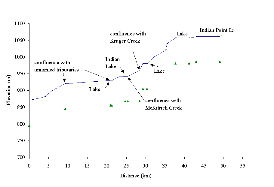 Indian Point Creek (100-6570-632)
flows north-west into the Bowron River (Figure 12). The sub-basin drains an
area of 249.2 km2, and has a mainstem length of approximately 50km
with 12 reaches, as delineated in the gradient profile (Figure 13). Two major
lakes and several smaller lakes are held within the sub-basin. Indian Lake
is located 25km upstream of the Indian Point Creek and Bowron River confluence;
Indian Point Lake is located in the headwaters of Indian Point Creek.
Indian Point Creek (100-6570-632)
flows north-west into the Bowron River (Figure 12). The sub-basin drains an
area of 249.2 km2, and has a mainstem length of approximately 50km
with 12 reaches, as delineated in the gradient profile (Figure 13). Two major
lakes and several smaller lakes are held within the sub-basin. Indian Lake
is located 25km upstream of the Indian Point Creek and Bowron River confluence;
Indian Point Lake is located in the headwaters of Indian Point Creek.
Figure 13. Gradient profile of Indian Point Creek with 12 reaches delineated by triangles.
Indian Point Creek is characterised as a sinuous marshy channel with extensive riffle and pool habitats. Although logging intensity in the sub-basin is high, the topography and stream channel has made it less susceptible to harvesting impacts (Bowron Watershed Committee, 1997). Approximately one third of the Indian Point Creek is located within the TFL 52 study area. Only this area was assessed. Within the study area, one cutblock along the Indian Point Creek mainstem was identified. The area, which was harvested to the stream bank on both sides of the channel between 1965 and 1978, was left to regenerate naturally. This area is recommended for site level riparian assessments as the area is classified as NSR, and riparian function is suspected of being impaired. Harvesting activities have also removed the RMA vegetation along the north bank of an unnamed tributary, located west of the Indian Point Creek mainstem. This area was harvested in 1987 and planted with spruce in 1988 and 1989. This area is also recommended for site level assessments because of suspected riparian function impairments, namely LWD, stream shading, and bank stabilzation, resulting from RMA vegetation removal.
Priority Segments for Site Level Assessments
Table 6 identifies segments where riparian function is suspected of being lost or impaired and prioritizes these segments for site level assessments. Refer to Site Level Riparian Assessment maps for priority site locations.
Table 6. Priority Riparian Segments in Indian Point Creek Sub-basin
|
Sub-basin name |
Reach # |
Stream Classi- fication |
Seg-ment # |
Segment Length (km) |
Riparian Vegetation Types |
Riparian Function impairments (based on Table B4 of Appendix B) |
Priority rating for site level riparian assessments |
||
|
Indian Point Creek |
8 |
S3 |
1 |
0.32 |
SHls/SPl |
stream shading,LWD, SOD, channel stability, sediment filtering, nutrient filtering |
High |
||
|
Un-named tributary |
1 |
S3 |
2 |
0.70 |
SHls/SPl |
stream shading,LWD, SOD, channel stability, sediment filtering, nutrient filtering |
High |
||
4.5. Kruger Creek Sub-basin area
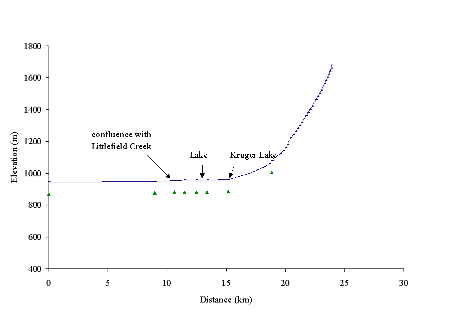 Kruger Creek (100-6570-632-567)
flows northwest into Indian Point Creek and drains an area of 55 km2
(Figure 12). The creek has a mainstem length of approximately 24 km
with eight reaches delineated in the gradient profile (Figure 14). Four km
of the Kruger Creek mainstem lies within the TFL 52 study area; only
this segment was assessed.
Kruger Creek (100-6570-632-567)
flows northwest into Indian Point Creek and drains an area of 55 km2
(Figure 12). The creek has a mainstem length of approximately 24 km
with eight reaches delineated in the gradient profile (Figure 14). Four km
of the Kruger Creek mainstem lies within the TFL 52 study area; only
this segment was assessed.
Figure 14. Gradient profile of Kruger Creek with eight reaches delineated by triangles.
The Kruger Creek sub-basin has been harvested along the lower 4 reaches of the creek and along tributaries. Riparian buffers have been maintained in several areas, however, cut-blocks are also located directly adjacent to the stream channels in a few locations. The Upper Bowron River IWAP indicated that the Equivalent Clearcut Area for Kruger Creek sub-basin was low at 20% (Bowron Watershed Committee, 1997).
Kruger Creek is characterised as a sinuous marshy channel with extensive riffle and pool habitats. Observations of the stream channel were limited due to the air photo scale, stream cover and the relative size of Kruger Creek.
The following briefly describes the Kruger Creek study area on a reach basis, based on available data. The lower reaches of Kruger Creek are characterised by a sinuous riffle-pool habitat. One area along the mainstem in reach 1 and two areas along tributaries within the first two reaches have been harvested, and riparian concerns have resulted. Since chinook use the main channel for spawning, and likely rearing, reaches 1 and 2 (and tributaries) should be assessed for logging impacts on fish habitat. These reaches are recommended for site level riparian assessments.
Priority Segments for Site Level Assessments
Table 7 identifies segments where riparian function is suspected of being lost or impaired and prioritizes these segments for site level assessments. Refer to Site Level Riparian Assessment maps for priority site locations.
Table 7. Priority Riparian Segments in Kruger Creek Sub-basin
|
Sub-basin name |
Reach # |
Stream Classi- fication |
Seg-ment # |
Segment Length (km) |
Riparian Vegetation Types |
Riparian Function impairments (based on Table B4 of Appendix B) |
Priority rating for site level riparian assessments |
|||||||
|
Kruger Creek |
1 |
S3 |
1 |
0.25 |
SHls/PlSx |
stream shading,LWD, SOD, channel stability, sediment filtering, nutrient filtering |
High |
|||||||
|
Unnamed tributary |
1 |
S3 |
2 |
0.80 |
SHls/PlSx |
stream shading,LWD, SOD, channel stability, sediment filtering, nutrient filtering |
High |
|||||||
|
Unnamed tributary |
1 |
S3 |
3 |
0.80 |
SHls/PlSx |
stream shading,LWD, SOD, channel stability, sediment filtering, nutrient filtering |
High |
|||||||
Figure 15. McKenna Creek flows north into Spectacle Lake, part of Bowron Lake Provincial Park. Fish distribution is based on the Overview assessment.
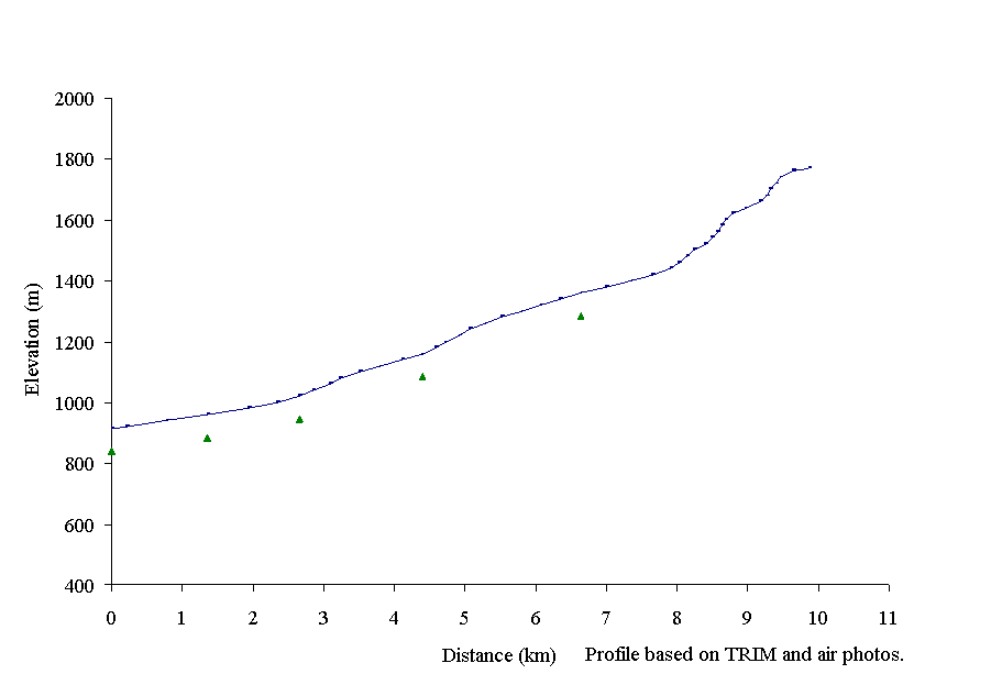 McKenna Creek (100-6570-818-960)
flows west into Spectacle Lake, which is in the Bowron Lake Provincial Park
canoe circuit. The McKenna Creek sub-basin elevation ranges from 914m at Spectacle
Lake to 1770m in its headwaters (Figure 15). The mainstem has a length of
approximately 10 km with five reaches delineated in the gradient profile (Figure
16).
McKenna Creek (100-6570-818-960)
flows west into Spectacle Lake, which is in the Bowron Lake Provincial Park
canoe circuit. The McKenna Creek sub-basin elevation ranges from 914m at Spectacle
Lake to 1770m in its headwaters (Figure 15). The mainstem has a length of
approximately 10 km with five reaches delineated in the gradient profile (Figure
16).
Figure 16. Gradient profile of McKenna Creek with five reaches delineated by triangles.
No fish distribution data is available for McKenna Creek, however a fish inventory is proposed for 1998. The McKenna Creek sub-basin has been extensively harvested along the upper reaches of the mainstem and tributaries. Riparian buffers have been maintained in several locations, however, in some areas, cut-blocks are directly adjacent to the creek. The upper Bowron River Level 1 IWAP indicated that the Equivalent Clearcut Area (ECA) for McKenna Creek sub-basin is 26%.
McKenna Creek is characterised as a sinuous marshy channel with extensive riffle and pool habitats. Observations of the stream channel were limited due to the air photo scale, stream cover and the relative size of McKenna Creek. Some tributaries are not visible at this scale of photography (1:15 000). Seven km of the mainstem of McKenna Creek lie within the TFL 52 study area. Only this area was assessed.
Two harvested areas along the mainstem, and two harvested areas along two tributaries were assessed during this overview for potential impairments to riparian function.
The first stream segment that was assessed consists of a 2600m long section of reach 5 of the McKenna Creek mainstem.This area consists of two sections; a 900m segment which was harvested in 1991 and planted with pine in 1992 and a 1700m segment which was harvested in 1985-86 and planted with spruce in 1987. Half of the 900m segment was harvested on the east side of the stream only; the west side consists of a mature spruce-balsam forest. The harvested area is well vegetated with regenerating conifer species and shrubs. A riparian buffer was maintained along the remaining portion, and the harvested area is also well vegetated with regenerating conifer species and shrubs. No riparian concerns were identified within this segment. A riparian buffer was maintained along the 1700m segment, and the area is well-vegetated with regenerating conifer species and shrubs. Seven landings are located within this cutblock, however they are not located within the RMA and are therefore not expected to be causing any significant concerns. No riparian function impairments were identified.
The second area which was assessed consists of a 1300m segment of reach 4 of the McKenna Creek mainstem. The area along both sides of the stream was harvested in 1981, planted with pine in 1983 and fill-planted in 1991. A riparian buffer was maintained at the time of harvesting and the remaining area is well vegetated. No riparian function concerns were identified.
The third area consists of a 900m segment of a tributary of McKenna Creek which was harvested in 1981-82 and planted with spruce in 1986. The area is well-vegetated with regenerating conifer species and shrubs, and no riparian impairments were identified.
The fourth area within the McKenna Creek sub-basin that was assessed for riparian function impairments consists of a 2300m segment of a tributary of McKenna Creek. The stream is not visible at this scale of photography. The area surrounding the stream was harvested in 1974-75 and planted with spruce in 1976-78. The harvested area is now well vegetated with a pole-sapling stage forest of mixed conifer and deciduous species. Riparian function in this area does not appear to be impaired.
Harvested areas within the TFL 52 study area of this sub-basin are recovering well from any impairments which may have been caused from harvesting activities. No further assessments have been recommended.