MACHMELL WATERSHED
LEVEL I FISH HABITAT ASSESSMENT
VOLUME I
JULY, 1998
Prepared by
Judy E. Hillaby
under contract to
Western Forest Products Ltd.
Mainland/Islands Region,
#118 - 1334 Island Highway,
Campbell River, B.C.
V9W 8C9
for submission to
Ministry of Environment, Lands and Parks,
680 Borland Street,
Williams Lake, B.C.
V2G 4T1
A program conducted through the auspices of Forest Renewal B.C., Contract # CCA - 855
The author wishes to recognize those individuals who conducted and assisted in the field work, during often adverse field and weather conditions. Mike Wigle, Mike Edmunds, Frank Hanuse Jr., and Patrick Johnson of the Gumbooters team; Lisa Forrington, Fred Smith, and John Johnson of the Happenings team; Ardice Neudorf, Lindsay Windsor, Ted Walkus and Rick Shaw of the Bravo team; and Wayne Jacob, Ivy Hanuse, Donovan LeBlonde and Clifford Smith of the Ol’ Chums team. Thanks are also due to Mark Rourke of Coast Forest Management, as well as Troy Larden, Mike Parker and Mike Howard of the Ministry of Environment, Lands and Parks in Williams Lake, for their contribution to organization, funding and quality control.
Extensive field support was required for this project, which was ably provided by Western Forest Products, through their workers at the Machmell and Sheemahant camps. These were headed by Dale Reinholz of G.B. Logging in Machmell camp and Nikki Skarvig of Western Forest Products in Ladysmith. Aircraft support was excellent, provided mostly by Forest Industries Flying Tankers, as well as by Vancouver Island Helicopters, Sharp Wings Ltd., Quatna Air, and Timberline Air. Considerable boat transportation was also provided by individual crew members, with the support of the Oweekeno Nation, which is gratefully acknowledged.
Considerable data organization was required to compile this report. Gordon Hanuse and Wayne Jacob, of the Oweekeno Nation, put in many long hours to this end and their efforts are greatly appreciated. Ardice Neudorf of Madrone Consultants very capably completed the hydrology overview and GIS integration, and contributed to the overview research and report as well. Carolyn Deering also provided great assistance at the word processing, photo archiving and final report assembly stage.
Special thanks also goes to Bob Brand and Bill Dwyer of Western Forest Products, as well as Percy Walkus and Alex Morris of the Oweekeno Nation, for ensuring that this project was properly initiated and brought to its conclusion.
1.0 EXECUTIVE SUMMARY
2.0 ACKNOWLEDGMENTS
3.0 BACKGROUND
4.0 OBJECTIVES
5.0 HYDROLOGY
5.1 Watershed Characteristics
5.2 Climate
5.3 Discharge and Rainfall
5.4 Impacts
6.0 METHODS
6.1 Field
6.1.1 Watershed Approach
6.1.2 Access
6.1.3 Field Data
6.1.4 Field Positioning
6.1.5 Fish Capture
6.2 Quality Control
6.2.1 Supervision
6.2.2 Data Checking
6.2.3 Flood Events
6.3 Data Handling
7.0 RESULTS
7.1 Lower Machmell - Reaches 1-1 to 2-3
7.1 1 Field Survey Approach
7.1.2 Possible Effects of Forest Harvesting
7.1.3 Fish Habitat Found
7.2 Machmell Canyon - Reaches 2 - 4 to 4-1
7.2.1 Field Survey Approach
7.2.2 Possible Effects of Forest Harvesting
7.2.3 Fish Habitat Found
7.3 Pashleth Bench Tributaries
7.3.1 Field Survey Approach
7.3.2 Possible Effects of Forest Harvesting
7.3.3 Fish Habitat Found
7.4 Genesee/Walkus System - Reaches 1 to 5
7.4.1 Field Approach
7.4.2 Fish Habitat Found
7.5 Fish Distribution
7.5.1 Obstructions to Fish Migration
7.5.2 Fish Sampling
8.0 Habitat Condition Assessment
8.1 Data Limitations
8.2 Fish Habitat
8.2.1 Fish Habitat Assumptions
8.2.2 Spawning Habitat Limitations
8.2.3 Juvenile Rearing Habitat Limitations
8.3 Fish Habitat Rehabilitation Priorities
9.0 RESTORATION OPPORTUNITIES
9.1 Restoring Bank Stability
9.1.1 Clear Creek Bank Stabilization
9.1.2 14.5 km Creek Upslope Stabilization.
9.1.3 20 km Creek - left fork bank stabilization
9.1.4 9.8 km Creek Bank Stabilization
9.2 Restoring Off-channel Habitats at the Cliff Base
9.2.1 Genessee Creek Flow Consolidation
9.2.2 Clear Creek Off-Channel Habitat
9.3 Spawning Channel Restoration
9.3.1 Right Bank Groundwater Channel Construction
9.3.2 Side Channels Near Oxbow.
9.3.3 Machmell River Oxbow Restoration
9.4 In-stream Habitat Restoration
9.4.1 5 km Creek Access Improvement.
9.4.2 Machmell Reach 1 - Trib #1 Restoration
9.4.3 20 km Creek In-Stream Restoration
SUMMARY OF RECOMMENDATIONS
LIST OF ABBREVIATIONS
LITERATURE CITED
At the request of Pacific Forest Products (now Western Forest Products), Forest Renewal B.C. has provided funding to undertake a Level I Fish Habitat Assessment on the Machmell River. In August and September of 1997, a Fish Habitat Overview study was conducted, which concluded that there were several species of fish that were potentially affected by fish habitat degradation, especially in the lower 20 km of the Machmell River where logging activity has been concentrated. With the cooperation of the Oweekeno Nation and with the technical and professional assistance of other consultants, field work was initiated in October 1997.
The overview assessment outlined approximately 40 km of stream length to be considered (considering both banks of the mainstem). Field work would be directed to approximately half of that which was identified as "high" or "medium" priority assessment. The initial restoration strategy outlined the potential for:
To provide directed field information that refined the opportunities identified in the overview assessment, a Level I Fish Habitat Assessment was conducted. Its general objectives were:
In this case, the field studies focused on:
Consistent with the broader objectives of Forest Renewal B.C., it was also important to develop a closer working relationship between workers at the Oweekeno Nation and the forest licensees. Accordingly, this project provided the means to capture the knowledge and perspective of both local residents and forest industry workers.
The Machmell River is a glacially fed fourth order stream with a magnitude of 146. Peak flows are influenced by a high degree of seasonal streams (approximately 1,252 ephemeral streams were noted). Elevation ranges from just above sea level near the mouth of the river to 7600m at Mt. Buzza. The study area for this project extends to the Pashleth River; approximately 22 kilometers upstream. Upper reaches of the study area are characterized by sheer bedrock walls that form a canyon which runs for approximately three quarters of a kilometer. The morphology of the Machmell River in this area is dominated by cascades with a vegetated island at the confluence of the Pashleth River. Although the Pashleth joins the Machmell at the bottom of the canyon, most other tributaries generally drain from the hillsides onto a terraced platform and then plummet over the bedrock cliffs to the mainstem below. Downstream of the canyon, bedrock walls still dominate the landscape with a few areas of steep but sloping hills. The river’s width increases and riffle morphology dominates the channel with intermittent vegetated and unvegetated islands. From the mouth of the Machmell to approximately seven kilometers upstream, the area is characterized by a fluvial fan and flood plain. The lower reaches of this area also encompasses one of the major tributaries in the study area the Neechanz. Immediately to the northeast, the Genesee Creek/Walkus Lake watershed also shares the delta and the two systems have been periodically connected by a flood channel.
The Machmell River is found in the Coastal Western Hemlock zone which is comprised of three biogeoclimatic subzones. The Central Moist Submaritime Coastal Western Hemlock Variant (CWHms2) subzone occurs in the lower elevations (below 700m) of the Machmell River. The climate in this area is characterized by moist, cool winters and cool but relatively dry summers. The vegetation in this area is dominated by mountain hemlock, Douglas-fir, western red cedar and amabilis fir. Common understorey species include Alaskan blueberry and a well developed moss layer. At elevation ranges from 700 to 1000m, the Montane Wet Submaritime Coastal Western Hemlock Variant (CWHws2) occurs. This subzone is characterized by moist, warm summers and cool to cold winters with relatively heavy amounts of wet snowfall. Large glaciers at the head of this drainage produce cold air that can influence the climate. The Winward Moist Maritime Mountain Hemlock Variant (MHmm1) is found at upper elevations. Climate at this subzone has long, wet cold winters and short cool moist summers. Total snowfall is usually high, which can result in substantial snowpacks that may persist well into July. Forests in this site are usually dominated by amabilis fir and mountain hemlock. Vegetation and stand characteristics are strongly influenced by local topography, which can in turn affect the timing and pattern of snowmelt.
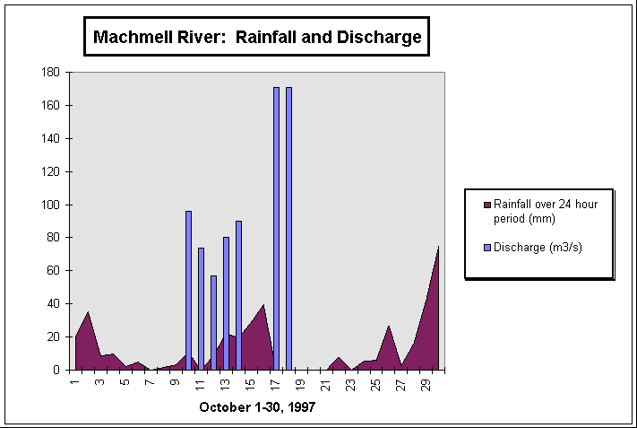
From October 10th to the 18th, flow discharge and rainfall precipitation was measured and the results were recorded as indicated in Figure 1. Discharge was measured at the Machmell bridge (approximately 7km upstream) by calculating a cross section of the river and using a timed floating object over a predetermined length. These calculations were then multiplied by 0.75 to compensate for the increase in velocity found at the surface. There is a lapse in the data from October 15th - 16th due to the staff gauge being swept away during a peak flow period. Rainfall was collected from Clear Creek using an AES standard precipitation gauge. These data, although inconclusive, suggest that the Machmell River responds rapidly to a rainfall event.
There are no historical data for this area to demonstrate changes in peak flow as a result of clear-cutting, but studies of similar watersheds have shown this relationship to be true (Duncun, 1986, Garbrecht, 1991, Jones, 1994). Any change in the flow patterns are a concern to the fish population as it can lead to scouring of spawning habitat, an increase in sedimentation and degradation of rearing areas. In the upper Machmell there are few pools and off-channel habitat, although those that do exist are used by salmonids. Significant increases in flow can therefore severely limit fish populations by degrading the few areas that are available. Further studies should be initiated to determine to what degree the fish stocks of the Machmell River are being affected by hydrological impacts.
Figure 1. Rainfall and discharge patterns for Machmell River during the study period.
Figure 2: Aerial views of Machmell River, Reach 2, facing upstream. Upper photo was taken in 1989 (DAS 89062 No. 150). Vegetated area outlined in red has since been washed away. Lower photo shows Main Channel closest to the right bank on October 4, 1997. Upper photo in Figure 3 was taken at the downstream end of the red zone.
Figure 3: Machmell River, Reach 2, facing downstream towards Oweekeno Lake. Upper photo shows new channel formation in Reach 2-2 on October 4, 1997, after 35 mm of rain in 24 hours. Lower photo shows area perspective on the same date, with new channel formation in the lower right corner of the frame.
The mainstem Machmell River was not walked extensively, due to its large size and flood potential. Field studies were directed towards associated side channels, tributaries and back channels that may provide fish habitat, as well as to low-gradient tributaries. As defined in the overview assessment, surveys were primarily limited to the area just downstream of the Pashleth Creek confluence, to the top of Reach 5. During the field work, it was apparent that many areas of the mainstem would remain inaccessible and during high flood events, crews were directed into safer areas.
The Genesee Creek/Walkus Lake watershed shares a delta with the Machmell and is included in the study area. Reach 1 of Genesee Creek refers to a 1 km section that provides important sockeye spawning beds and grizzly bear refuge habitat. Its apparent dewatering is causing significant concern to DFO and to the Oweekeno Nation. Field surveys in this study were intended only to describe site-specific conditions to complement existing knowledge gained by other parties. Accordingly, a comprehensive, watershed-based approach was not conducted in this drainage.
The access approach was to walk up and assess the mainstem Machmell River, wherever possible, and to locate and assess the significant tributaries and side channels encountered. Both sides of the river were walked in Reaches 1 and 2, and spot-checked in Reach 3. Many off-channel habitats and tributaries were located in this manner. Three and four-member crews were dropped in by helicopter, and truck access was also used in the lower reaches. Where the access plan permitted, stream walking was normally conducted in an upstream manner. Some areas remained inaccessible, due to inaccessible canyons (Machmell Reaches 4 and 5; Pashleth Reaches 1, 2 and 3).
Crews gathered site-specific information on both tributary and mainstem habitats, focusing on off-channel and tributary habitats. Reach descriptions in the mainstem were on a subsampling basis, determined by a projected length of stream to walk each day. During the stream survey, subsampling by habitat type (1 in 3 riffles, 1 in 2 glides, all pools) was conducted, according to the criteria outlined in Technical Circular No. 8. Field data recorded was consistent with the FHAP Level I data form, but modified to include more detailed temperature and discharge measurements, as well as stream bank characteristics. Crew members also recorded a stream habitat log, correlated with hip chain measurements, and an accompanying diagram that explained more complex stream configurations and habitats. A photo log was also kept, and all photos were labeled and catalogued for archive purposes.
All crews had 1:20,000 Trim maps, compasses, and aerial photos, and were carefully oriented by truck or helicopter before beginning their surveys. Some crew members had GPS equipment, and these were used for positioning where appropriate. Crews walked from known positions on the map, charting their location by hip chain distances, assisted by laser rangefinder distancing where necessary and appropriate. The progress of each crew was charted on master maps after each day’s work.
Fish capture was conducted primarily in off-channel habitats. As many habitats as possible were sampled, with consideration for the cost-effectiveness of access into difficult locations.
Minnow traps were usually set for 24 hours, but occasionally for 5 hours if it was cost-effective to do so. Electrofishing was not conducted in this system, due mostly to weather constraints, but also as minnow trapping was more effective for the locations sampled (beaver ponds and back channels).
Species identification was frequently checked by the crew supervisor. Microhabitat locations and characteristics for reach trap site were recorded, species and life stage was determined for all fish captured, and fish length recorded to the nearest 5mm for all salmonids.
The first line of quality control was in coordinating field traverses and supervision of all crew members. There was a short training session prior to the start of the field program, when habitat recognition and measurement of stream characteristics was repeatedly practiced and data recorded. At the start of the field program, extra supervisory assistance was given by a roving biologist, who traveled at least one day with each team to answer questions and reinforce field measurements and strategies. Data sheets, field notes, equipment anomalies, etc. were checked daily by each team’s leader and by the senior biologist. Location and extent of field surveys were charted daily and field information generally reconciled with map information. Field surveys were structured so that crews did not overlap, and survey start and end points were flagged in the field.
In the field, every fifth day was a "data day" when crews reviewed their work, assembled data in different formats, completed photo records, checked equipment operation, sent film out for processing, etc. The field information was reviewed and discussed with the project biologist, and checked for anomalies and significant findings.
Since most of the field survey locations were accessed only by helicopter, it was not cost-effective to re-survey the same area by a different crew for quality control purposes. Instead, photo records were kept that were used to re-check interpretations of different habitat types and correlate general observations.
Quality control concern was appropriately directed towards flood events. The Machmell watershed is subject to extreme flood events which sometimes obscured stream habitat units. This system responds very quickly to rainfall events, such that a deluge in the morning can raise the river level as much as 2m by late afternoon (Figure 1). Accordingly, depth and surface velocity measurements were taken at the lower Machmell bridge and used to derive discharge, which is then used to qualify the data record. It is not appropriate to precisely correlate measured stream depth, etc. with flood records without more detailed analysis. However, the flood events provided valuable information on the fluvial processes affecting stream habitat, which is a subject in itself.
When high rain events caused the river to rise, field crews were directed towards tributary habitats that were more visible at this time. Mainstem surveys were not appropriate when the river was rising, primarily due to the physical difficulties of negotiating the banks of this system, but also due to the bear population which moved off the gravel bars and began moving through the roads and high-level riparian trails, as they became unable to fish.
The data has been assembled and calculated in two documents. The Volume I - Summary contains summarized data and proposed restoration opportunities. Volume II - Data Appendices contain reproductions of the field sheets, sketch maps of certain areas, rough field notes, as well as detailed fish capture results.
In this volume, Form 4, Level I Habitat Survey Data Form, has been summarized for discussion purposes. The field reference code corresponds to an information bundle that is detailed in Volume II and located on the enclosed project maps. The reader is directed to this source for site-specific details.
Summarized data has been assembled as follows:
Reach and Reference: keys to the appropriate appendix information, with associated notes and diagrams.
Length: length of the survey that applies to this data set (may be truncated to better define reach and section delineations). Proportions of pools, glides, riffles and cascades are expressed as a percentage of this.
Off-Channel Habitat: The type of off-channel habitat found, and the length of it. Note that some areas had substantial lengths of old channel that were not accessible to fish at all. Lower reaches of tributary habitats were not included in this calculation.
Gradient, water depth, bankfull width: These are expressed as a range of values, as they differ substantially throughout the survey. This information is intended to generally describe how the channel characteristics change from reach to reach.
Substrate: This is expressed as the most frequent category of substrate that is described in the notes.
LWD Ratio: This describes the total length of the survey divided by the number of functional LWD. This figure does not include debris jams that are parallel to the mainstem that are better described as disturbance indicators.
7.1 Lower Machmell - Reaches 1-1 to 2-3
Field surveys were directed first towards locating unmapped tributaries, sidechannels and other off-channel habitats. A secondary objective was to assess the condition of existing fish habitats in the mainstem where possible. Extensive traverses across the flood plain were avoided due to potential bear hazard.
Table 1. Summary of field surveys in the lower Machmell River.
|
Field Reference Code |
Survey Objective |
|
OC-04 |
Lower Machmell Trib. #1. Surveyed through old cut block. Note map inaccuracies. |
|
OC-05 |
Mainstem Machmell and sidechannel areas. Mapping inaccuracies throughout this general area. |
|
OC-06 |
Mainstem sidechannel area. Mapping inaccuracies throughout this general area. |
|
OC-07 |
Mainstem sidechannel area, very brief notes. Mapping inaccuracies throughout this general area. |
|
OC-08 |
Lower Machmell Trib. #2. Surveyed 430m, note map inaccuracies. |
|
OC-09 |
Walked road inspecting tributary mouths. Found very few, due to adjacent steep slopes. |
|
OC-10 |
Major sidechannel area. Mapping inaccuracies throughout this general area. |
|
M-01 |
Clear Creek, upper (cut block) was walked. |
|
M-02 |
Clear Creek, lower (near Machmell confluence) was walked. |
|
M-03 |
6 km Creek, above road crossing. |
|
M-04 |
6 km Creek, below road crossing. Long dewatered section. |
|
GB-05 |
Mainstem Machmell (right bank) walked, looking for off-channel habitat. Most areas dry. Lake intrusions (no flow) are briefly surveyed. See also photos and diagrams. |
|
GB-06 |
5 km Creek walked, to survey fish habitat upstream of obstructions at Machmell River confluence. |
7.1.2 Possible Effects of Forest Harvesting
The Machmell is a large river system and flooding in the mainstem is extreme (see Figure 2). Whether or not logging has affected this pattern must be addressed separately. It is clear that there are significant indicators of channel disturbance, including parallel debris jams, elevated mid-channel bars, eroding banks, etc. The bedrock constriction under the bridge at Reach 2-3 has a "nozzle" effect on stream flow and most of the channel disturbance is downstream of this point.
Generally, the mainstem channel is moving towards the right bank, to the extent that TRIM maps and 1991 airphotos are profoundly inaccurate. This movement is causing the left bank to dry out, as evidenced by encroaching vegetation and gravel compaction, shallow vegetated tributaries, and elevated sidechannel areas. The right bank is characterized by eroding, unstable banks, and new sidechannel formation.
Attempts to control flooding of the camp infrastructure have been made by construction of berms set back from the mainstem (right bank) and riprapping along the road. These have also contributed to channel formation patterns.
Besides the presence of some spawning area in the mainstem channel, fish habitat was limited to a few stable, off-channel areas:
7.1.3 Fish Habitat Found
7.1.3.1 Oweekeno Lake Intrusions:
These two channels are to the north of the Machmell River mouth, adjacent to the Machmell camp. They appear to be flood channels that were cut off in the upstream end and are now fingers of lake intrusion. Field traverses found the first channel just northeast of the Machmell confluence (only 71m long). The second is farther along the lakeshore and extends 600m inland (see figure 5). Only the second channel has stream survey data.
Table 2: Summary of fish habitat characteristics for Oweekeno Lake intrusions (channel number 2), north of Machmell River mouth.
|
Criteria |
|
|
Field Reference |
GB - 5 |
|
Survey Length |
600 m |
|
Habitat Types: |
|
|
% Pools |
0% |
|
% Riffles |
0% |
|
% Glides |
100% |
|
% Cascades |
0% |
|
Off-Channel Habitat |
|
|
Total length |
None |
|
Type |
|
|
Gradient |
0 |
|
Depth |
.25 - 1.1m |
|
Bankfull width |
2.7 - 6.5 m |
|
Dominant Substrate |
Fines |
|
Subdominant Substrate |
Cobble |
|
No. of LWD per distance of stream length |
Piled at mouth |
|
No. of holding pools per distance of stream length |
1 long slough |
Figure 4: Oweekeno Lake intrusions adjacent to Machmell camp. Upper photo in high water near mouth of Machmell River. Lower photo is a second channel to the north.
Figure 5: Lake intrusion channels near the right bank of Machmell River mouth.
7.1.3.2 Lower Machmell - Left Bank Tributaries
Table 3. Summary of fish habitat characteristics in Tributaries 1 and 2, flowing into the mainstem Machmell in Reaches 1 - 1 and 1 - 4, left bank.
|
Criteria |
1 - 1 left bank |
1 - 4 left bank |
|
Field Reference |
OC - 4 (trib. #1) |
OC - 8 (trib. #2) |
|
Survey Length |
1,828m |
359m |
|
Habitat Types: |
- |
- |
|
% Pools |
11% |
13% |
|
% Riffles |
70% |
8% |
|
% Glides |
19% |
79% |
|
% Cascades |
- |
- |
|
Off-Channel Habitat |
- |
- |
|
Total length |
0 |
0 |
|
Type |
- |
- |
|
Gradient |
.5 % |
0 - 1% |
|
Depth |
.85 m |
.05 - .7 m |
|
Bankfull width |
4.8 m |
2.4 - 4.3 m |
|
Dominant Substrate |
C |
F |
|
Subdominant Substrate |
F |
G |
|
No. of LWD per distance of stream length |
1:13 m |
1:6 m |
|
No. of holding pools per distance of stream length |
1:609M |
1:418 m |
Figure 6: Upper photo is at 913 m on Trib. #1 (OC-4) showing open canopy and vegetation in the stream bed. Lower photo is at 257m in Trib. #2 (OC-8) and shows an example of the woody debris in this stream.
7.1.3.3 Lower Machmell - Left Bank Sidechannels
Table 4. Off-channel fish habitats on the left bank of the lower Machmell River.
|
Criteria |
1-1 |
1-3 |
1-4 |
1-5 |
|
Field Reference |
OC-05 (partial) |
OC-06 |
OC-07 |
OC-10 |
|
Survey Length |
117m |
421m |
108m |
381m |
|
Habitat Types: |
||||
|
% Pools |
0 |
1% |
0 |
7% |
|
% Riffles |
59% |
12% |
0 |
56% |
|
% Glides |
51% |
87% |
100% |
37% |
|
% Cascades |
0 |
0 |
0 |
0 |
|
Off-Channel Habitat |
||||
|
Total length |
27m + |
|||
|
Type |
SC |
|||
|
Gradient |
.5 - 1% |
0 - 2% |
0 |
0 - 2% |
|
Depth |
.38 - .63m |
.02 - .26m |
.2m |
.28 - .63m |
|
Bankfull width |
36 - 103 |
8 - 21 |
14 |
12 - 30 |
|
Dominant Substrate |
G |
G |
F |
G |
|
Subdominant Substrate |
F |
C/F |
C |
|
|
No. of LWD per distance of stream length |
1:2 |
1:23 |
Beaver dams |
1:48 |
|
No. of holding pools per distance of stream length |
0 |
0 |
0 |
0 |
Figure 7: Machmell River, Reach 1, Section 4 (upper) and Reach 1, section 2 (lower), left bank showing stable, compacted banks with initial vegetation. Photos taken in flood conditions (Oct. 4).
Figure 8: Machmell River, Reach 1, Section 3, right bank, showing flooding, erosion, and debris after high rainfall. (Oct. 4).
7.1.3.4 Lower Machmell - Right Bank Tributaries
Table 5: Summary of fish habitat characteristics in 5 km and 6 km Creeks, flowing into the lower Machmell in Reaches 2 - 1 to 2 - 3.
|
Criteria |
2 - 1 right bank |
2-2 to 2-3 right bank |
|
Field Reference |
GB - 06 (5 km creek) |
M - 03,04 (6 km creek) |
|
Survey Length |
518m |
649m |
|
Habitat Types: |
- |
- |
|
% Pools |
40% |
09% |
|
% Riffles |
10% |
15% |
|
% Glides |
50% |
76% |
|
% Cascades |
- |
- |
|
Off-Channel Habitat |
- |
- |
|
Total length |
0 |
0 |
|
Type |
- |
- |
|
Gradient |
0 - 1% |
0 - 1.5% |
|
Depth |
.1 - 2 m |
.15 - .4 m |
|
Bankfull width |
2.1 - 18 m |
.6 - 7.2 m |
|
Dominant Substrate |
F |
F |
|
Subdominant Substrate |
G |
- |
|
No. of LWD per distance of stream length |
1:14 m |
1:49 m |
|
No. of holding pools per distance of stream length |
1:518 m |
1:649 m |
Figure 9: 5 km Creek. Upper photo is approximately 300m upstream of road crossing, where stream channel flows are parallel to mainline road, at the toe of the slope. Lower photo shows stream channel at 600m, re-routed by road construction.
Figure 10: 6 km Creek, entering the Machmell River in the right bank in Reach 2-2 (white spot in lower left corner of lower photo). Upper photo is the same creek, behind mainline road.
7.1.3.5 Lower Machmell - Steep-Slope Tributaries
Table 6. Clear Creek fish habitat description.
|
Criteria |
Clear Creek - lower (Reach 1) |
Clear Creek- upper (Reach 2) |
|
Field Reference |
M-02 |
M - 01 |
|
Survey Length |
195m |
783 m |
|
Habitat Types: |
- |
|
|
% Pools |
0 |
0% |
|
% Riffles |
100% |
33% |
|
% Glides |
0 |
0% |
|
% Cascades |
0 |
67% |
|
Off-Channel Habitat |
- |
|
|
Total length |
45m |
45 m |
|
Type |
SC |
SC |
|
Gradient |
7% |
7 - 43% |
|
Depth |
.36m |
.3 - 1.18 m |
|
Bankfull width |
11m |
6 - 13.5 m |
|
Dominant Substrate |
Cobble |
Cobble |
|
Subdominant Substrate |
Gravel |
Gravel |
|
No. of LWD per distance of stream length |
0 |
Jams |
|
No. of holding pools per distance of stream length |
0 |
0 |
Figure 11: Upper photo is Clear Creek, Reach 2, adjacent to cut block on right bank (M-01). Lower photo is Clear Creek, Reach 1, ~100m upstream of confluence with a sidechannel of the Machmell River (M-02).
7.2 Machmell Canyon - Reaches 2 - 4 to 4-1
The mainstem Machmell River in these sections is confined between high bedrock walls, but has no fish obstructions until Reach 4. The shifting, shallow nature of the river bed also makes jet boat access impractical and unreliable (tested during the field survey). However, during low water conditions some of the mainstem bars were accessible by helicopter. Accordingly, limited surveys were carried out in the mainstem.
Field crews searched for and surveyed any available off-channel habitats that may be accessible to mainstem fish downstream of the Reach 4 obstructions. These areas would specifically include the mouths of the tributaries falling off the canyon walls. Any associated sidechannels or backchannels were to be surveyed and measurements taken that would help assess their condition. Measurements of the mainstem channel were also taken, where possible.
Table 7. Summary of field surveys in the Machmell canyon area.
|
Field Reference Code |
Survey Objective |
|
BR-01 |
Off-channel habitat upstream of bridge on right bank. Survey cut short re: bear encounter. |
|
BR-02 |
Off-channel habitat on right bank, documenting pre-logging condition. |
|
BR-03 |
Off-channel habitat on right bank, documenting pre-logging condition. Short distance of mainstem surveyed, as well. |
|
BR-04 |
Off-channel habitat on right bank, documenting pre-logging condition. |
|
BR-05 |
Short distance of mainstem surveyed. Left bank tributary habitat surveyed, ~200m to base of falls, downstream of logged area and road crossing. |
|
BR-07 |
Mainstem surveyed to locate off-channel habitats on the right bank (unlogged). Both mainstem and some sidechannel habitats surveyed. |
|
BR-08 |
Mainstem surveyed to locate off-channel habitats on the right bank (unlogged). Very little off-channel habitat found. |
|
BR-09 |
Mainstem surveyed to locate off-channel habitats on the right bank (unlogged). No off-channel habitat found. |
|
BR-10 |
Left bank tributary through logged area at 14.5 km Creek surveyed, at Machmell confluence. |
|
BR-11 |
Left bank tributary through logged area at 14.5 km Creek surveyed, below bridge crossing, well above Machmell confluence. |
|
HP-01 |
Surveyed off-channel habitat below mainline road crossing on left bank. Complex tributary and sidechannel area, at toe of the slope. |
|
HP-02 |
Surveyed ~800m of mainstem Machmell and located complex tributary and sidechannel area. Surveyed off-channel habitat at toe of the slope. |
|
HP-04 |
Surveyed ~1,800m of mainstem Machmell and sidechannels. Located complex tributary and off-channel habitat area and surveyed ~300m. |
7.2.2 Possible Effects of Forest Harvesting
Due to the steep canyon walls, forest harvesting is nowhere near the mainstem channel. However, some roads and cut blocks have affected the banks and slopes of the steep tributaries and gullies on the left bank. While road work has stabilized most of these, the effect on fish habitats at the base of the cliff is important. A comparison of left bank (logged) and right bank (unlogged) shows that the left bank has had numerous slides, both new and old, that have inundated sidechannels and in-filled stable, complex stream habitats.
Nearly all of the tributary streams described on the TRIM maps do not provide fish habitat, in that they have in-stream gradients well over 20%. As expected, there is a very limited amount of fish habitat available:
7.2.3.1 Machmell Canyon - Mainstem
Table 8: Summary of fish habitat characteristics for mainstem Machmell River, Reaches 2 - 4 to 3-3.
|
Criteria |
2 - 6 |
2 - 7 |
2 - 7 |
3 - 2 |
3 - 3 |
3 - 3 |
3 - 3 |
|
Field Reference |
BR-3 |
HP - 2 |
BR-7 |
HP - 4 |
BR-8 |
BR 9 |
BR-5 |
|
Survey Length |
266m |
860m |
1,507m |
1,820m |
386m |
400m |
224m |
|
Habitat Types: |
|||||||
|
% Pools |
0% |
0% |
3% |
0% |
0% |
0% |
0% |
|
% Riffles |
70% |
62% |
27% |
56% |
42% |
37% |
95% |
|
% Glides |
30% |
38% |
26% |
23% |
0% |
6% |
0% |
|
% Cascades |
0% |
0% |
44% |
21% |
58% |
57% |
5% |
|
Off-Channel Habitat |
|||||||
|
Total length |
227m |
- |
64m |
- |
- |
- |
167m |
|
Type |
SC |
- |
SC |
- |
SC |
- |
SC |
|
Gradient |
0% |
1 - 4% |
0 - 4% |
1 - 5% |
3% |
3 - 3.5% |
2.5% |
|
Depth |
- |
.3 - 2.5 m |
.4 - 1% |
.3 - .8 m |
- |
- |
- |
|
Bankfull width |
51m |
40 - 75 m |
44 - 85m |
54 - 97 m |
70m |
60 m |
96m |
|
Dominant Substrate |
Cobble |
Cobble |
Cobble |
Cobble |
Cobble |
Boulder |
- |
|
Subdominant Substrate |
- |
Gravel |
Gravel |
Gravel |
- |
Cobble |
- |
|
No. of LWD per distance of stream length |
0m |
1:72 m |
0m |
1:165 m |
0m |
0m |
1:112m |
|
No. of holding pools per distance of stream length |
0m |
0m |
1:502m |
0m |
0m |
0m |
0m |
Figure 12: Mainstem Machmell River. Upper photo is looking downstream from the left bank at the Reach 2-7/Reach 3-1 break. Lower photo is looking downstream at Reach 2-5
7.2.3.2 Machmell Canyon - Off-channel Habitats, Right Bank (unlogged)
Six different mainstem areas could be accessed by field crews, and five of these yielded some evidence of off-channel habitat. Reaches 3-4 to 5 were not accessible in the mainstem. The right bank has not been logged and these streams should be considered control systems, in their pristine condition (except for BR-01, Reach 2-4). Refer to Volume II, Appendices, for site sketches and field notes for further information on individual areas. Note that only the confluence area where off-channel habitat exists was surveyed: the upper portions of the streams are very steep and do not provide fish habitat beyond the canyon floor.
Note that the 1,089m of off-channel habitat walked and surveyed represents most of it on this section of the right bank. There are no low-gradient tributaries off this bank, and none that allow more than a few meters of fish access from the mainstem.
Table 9. Summary of fish habitat characteristics for off-channel habitats in the right bank of the Machmell River, Reaches 2-4 to 3-1.
|
Criteria |
2 - 4 |
2 - 5 |
2 - 6 |
2 - 7 |
3 - 1 |
|
Field Reference |
BR-01 |
BR-02 |
BR-03 |
BR-07 |
BR-04 |
|
Survey Length |
195m |
242m |
221m |
365m |
|
|
Habitat Types: |
|||||
|
% Pools |
15% |
21% |
44% |
5% |
¾ |
|
% Riffles |
61% |
79% |
24% |
17% |
¾ |
|
% Glides |
24% |
0% |
32% |
52% |
¾ |
|
% Cascades |
0% |
0% |
0% |
26% |
¾ |
|
Off-Channel Habitat |
|||||
|
Total length |
¾ |
¾ |
¾ |
¾ |
¾ |
|
Type |
¾ |
¾ |
¾ |
¾ |
¾ |
|
Gradient |
0 - 2% |
0 - 4% |
0 - 2% |
0 - 6% |
0 - 2% |
|
Depth |
.2 - 8m |
.2 - .9 m |
.2 - .4m |
.2 - .7m |
.07 - 1m |
|
Bankfull width |
3 - 6m |
2 - 10 m |
3.8 - 8m |
7 - 45m |
29m |
|
Dominant Substrate |
Sand |
Sand |
Cobble |
Cobble |
Cobble |
|
Subdominant Substrate |
¾ |
Cobble |
¾ |
Gravel |
¾ |
|
No. of LWD per distance of stream length |
1:98m |
0 |
1:55m |
1:73m |
0 |
|
No. of holding pools per distance of stream length |
0 |
0 |
0 |
0 |
0 |
Figure 13: Upper photo is Reach 2-4 (BR-01) showing sandy substrate off seepage slope. Lower photo is Reach 2-5 (BR-02) showing tributary confluence with sidechannel.
Figure 14: Upper photo is Reach 2-5 (BR-02) showing beaver dam at toe of the slope. Lower photo is Reach 2-6 (BR-03) showing bedrock blocks in mainstem - influences sidechannel.
7.2.3.3 Machmell Canyon - Off-channel Habitats, Left Bank (logged)
Seven separate survey areas yielded six different off-channel habitats, representing most of the off-channel habitat in this section. Each of these areas has some influence from the steep-slope tributaries flowing off the left bank. There is some mainstem fish access into these tributaries, but only within the canyon walls; further up, the stream gradient is too steep to support resident fish.
Some of the tributaries flow through old cut blocks (9.8 km and 14.5 km Creeks) and all tributaries are crossed by the mainline road on the slope above. Steep cliffs and slope stability issues have dictated road design and engineering throughout the study area and are not specifically addressed in this work.
Impacts on fish at the bottom of the cliffs was the primary focus. One limited survey was one on 14.5 km Creek to assess potential sources of bedload material and wood debris.
Note that off-channel habitats can be difficult to describe in linear terms. Please refer to the field notes and sketches in the Appendices (Volume II) for further information on specific sites.
Table 10. Summary of fish habitat characteristics for off-channel habitats in the left bank of the Machmell River, Reaches 2-4 to 3-3.
|
Criteria |
2 - 6 "43m Creek" |
2 - 6 "249m Creek" |
2 - 7 |
3 - 2 |
3 - 2 "14.5 km Creek" |
3 - 2 "14.5 km Creek" |
3 - 3 "16 km Creek" |
|
Field Reference |
HP-01 |
HP-01 |
HP-02 |
HP-04 |
BR-10 |
BR-11 |
BR-05 |
|
Survey Length |
291m |
475m |
112m |
285m |
75m |
408m |
352m |
|
Habitat Types: |
|||||||
|
% Pools |
2% |
10% |
9% |
20% |
0% |
0% |
34% |
|
% Riffles |
5% |
3% |
51% |
38% |
40% |
1% |
0 |
|
% Glides |
93% |
87% |
40% |
30% |
0% |
0% |
5% |
|
% Cascades |
0% |
0% |
0% |
12% |
60% |
99% |
61% |
|
Off-Channel Habitat |
|||||||
|
Total length |
__ |
__ |
30m x 170m |
__ |
__ |
__ |
__ |
|
Type |
__ |
Trib |
Beaver pond |
__ |
__ |
__ |
__ |
|
Gradient |
0 - 7% |
0 - 7% |
0 - 1% |
0 - 5% |
10 - 17% |
15 - 24% |
0 - 15% |
|
Depth |
.1 - .18m |
.07 - .18m |
.09 - .23m |
.18 - 1.2m |
__ |
__ |
.39 - 1m |
|
Bankfull width |
2 - 7.3m |
1.35 - 11m |
1.1 - 2.0m |
7.2 - 17.4m |
5 - 5.3m |
__ |
5 - 11.7m |
|
Dominant Substrate |
Cobble |
Cobble/Fines |
Fines |
Cobble |
Cobble |
__ |
Boulder |
|
Subdominant Substrate |
Fines |
Fines |
__ |
Gravel |
Gravel |
__ |
Fines |
|
No. of LWD per distance of stream length |
1:20 |
1:34 |
1:56m |
1:142m |
1:7m |
1:6m |
1:25m |
|
No. of holding pools per distance of stream length |
0 |
0 |
0 |
1:285m |
0 |
0 |
1:352m |
Figure 15: Upper photo is "249m" Creek in Reach 2-6 (HP-01), 143m upstream from Machmell confluence. Lower photo is flooded areas (HP-02) at the base of a slide in Reach 2-7.
Figure 16: Upper photo shows cobble sidechannel in Reach 3-2 (HP-04). Lower photo shows fish habitat below the falls in Reach 3-3 (BR-05)
7.3 Pashleth Bench Tributaries
There are several low-gradient tributaries to the Machmell and Pashleth River that flow through cut blocks above the canyons, where Dolly Varden are recorded. None of these tributaries are accessible to mainstem fish; resident fish populations are clearly isolated. Road access was available, and field crews surveyed sections of 3 creeks, named here as 20 km (Susan) Creek, 22 km Creek and Trib. #2 flowing into Pashleth Creek at the Reach 2/Reach 3 break. Fish capture efforts were directed towards establishing the distribution of fish in these tributaries, and in determining species mix.
Table 11. Summary of field surveys in the Pashleth Bench area.
|
Field Reference Code |
Survey Objective |
|
OC-01 |
Pashleth Trib. #2. Surveyed to document pre-logging condition, and to determine extent of fish access. Limited data taken. |
|
OC-03 |
Pashleth Trib. #0. Short distance of low gradient habitat surveyed above the falls, on the edge of a cut block. Fish presence determined. |
|
GB-01 |
20 km (Susan) Creek surveyed from second bridge crossing (right fork). |
|
GB-02 |
20 km Creek surveyed from first bridge crossing (right fork). |
|
GB-03 |
22 km Creek surveyed adjacent to the road. |
|
HP-03 |
20 km Creek surveyed between falls and road crossing, left fork. |
7.3.2 Possible Effects of Forest Harvesting
All of these tributaries contained isolated populations of Dolly Varden, some living in very restricted habitats. Large portions of 20 km Creek, and 22 km Creek have been harvested to the stream edge with a consequent loss of riparian function. Slope stability has also compromised fish habitat in 20 km Creek. The most significant effect of forest harvesting is that there are significant in-stream barriers that are associated with LWD jams and debris piles that likely inhibit fish movement throughout the mainstem. Considering that these are relatively small creeks with small populations of fish that have very little ability to avoid unfavorable habitats, this effect is significant. Trib #2 flowing into the Pashleth system is an interesting control system, with mature coniferous forest, abundant LWD, alternating pool/riffle habitats, and relatively shallow water throughout its 1.1 km surveyed length.
Three streams were found that provide low-gradient fish habitat in the area of the Machmell - Pashleth confluence. Two streams flow through cut blocks, and all contain isolated populations of Dolly Varden. One stream (Pashleth Trib. #2) is in its pristine, unlogged condition. Another stream (22km Creek) has been logged to the stream edge and runs parallel to the road, but the stream channel remains stable, with good cover, and a rebuilding riparian zone. The third stream (20 km Creek) has significant stretches of eroding banks and other disturbance indicators and was surveyed in three separate locations.
Table 12. Fish habitat characteristics for the Pashleth Bench tributaries.
|
Criteria |
20 km Creek (upper, left) |
20 km Creek (lower, left) |
20 km Creek (right) |
22 km Creek |
Pashleth Trib. #2 |
|
Field Reference |
GB-01 |
GB-02 |
HP-03 |
GB-03 |
OC-01 |
|
Survey Length |
435m |
812m |
884m |
679m |
1,468m |
|
Habitat Types: |
|||||
|
% Pools |
26% |
6% |
7% |
3% |
5% |
|
% Riffles |
5% |
78% |
93% |
15% |
94% |
|
% Glides |
17% |
16% |
0% |
82% |
0% |
|
% Cascades |
52% |
0% |
0% |
0% |
1% |
|
Off-Channel Habitat |
|||||
|
Total length |
__ |
88m |
__ |
__ |
> 40m |
|
Type |
__ |
SC |
__ |
__ |
SC/WL/ TRIB |
|
Gradient |
3 - 12% |
1 - 3.5% |
0 - 3% |
1 - 5% |
.5 - 12% |
|
Depth |
.21 - .68m |
.3 - 1.1m |
.75 - 2m |
.12 - .65m |
.09 - .5m |
|
Bankfull width |
6.4 - 9.1m |
3 - 20m |
10 - 32m |
2 - 5.7m |
1.8 - 8.6m |
|
Dominant Substrate |
Cobble |
Gravel |
Cobble |
Cobble/ Fines |
Gravel/ Boulder |
|
Subdominant Substrate |
Gravel |
Cobble |
Boulder |
Gravel/ Fines |
Fines |
|
No. of LWD per distance of stream length |
1:10m |
1:9m |
1:52m |
1:13m |
1: 3m |
|
No. of holding pools per distance of stream length |
0 |
1:812m |
1:884m |
0 |
0 |
Figure 17: Upper photo shows the left fork, 20km Creek, at the base of the falls (HP-03). Lower photo shows a left fork dry braid, located 439m downstream of falls (HP-03).
Figure 18: Right fork of 20km Creek at 89m (upper photo) and 240m (lower photo) upstream of lower bridge crossing (GB-02).
Figure 19: 22km Creek,
showing stream sections
parallel to the road
Figure 20: Pashleth Trib. #2 at 1,142m upstream from falls. Fish were seen in the stream at this point.
7.4 Genesee/Walkus System - Reaches 1 to 5
Previous information (FISS) indicated that cutthroat trout are found in Walkus Lake, so it was assumed that fish habitat exists in all downstream areas. With this in mind, there were three areas of interest to this study:
Reach 1 was walked in late September by a team of DFO and MOF workers. The object of the walk was to determine:
The outcome was that while some channel drying was evident, the effect on sockeye spawn was argumentative. Hydraulic sampling was proposed as a way of quantifying sockeye egg-to-fry survival rates in various stream areas. Assuming spawning habitat damage, there were three potential solutions proposed to increase flow into the channel (in order of "practical" priorities):
In this study, two field surveys were conducted:
Reach 3 was not field surveyed due to an inappropriate risk factor. Aerial surveys indicated no significant slope movement in the stream itself, and planted riparian zones and cut slopes seemed to be growing well. It is generally inaccessible for potential restoration purposes.
As noted above, surveyed areas were directed towards stream sections where critical information was needed. Fish habitat existing throughout Reaches 1 to 6; however, there is no fish habitat on the southeast lake side, as a stream connection is lacking. This is contrary to the TRIM map (1:20,000 scale) information.
7.4.2.1 Genesee Creek - Top of Reach 1
This survey consisted of a few brief measurements and was cut short by bear activity. Photos and brief field notes indicate a disturbed area with piles of LWD forming a split channel that only partly re-consolidates back to the main channel. The age of the LWD seems to be approximately the age of the cut block above the falls. Some of the sidechannels contains good spawning gravel and sockeye spawners, and show signs of stabilizing (BR-12).
7.4.2.2 SE Walkus Lake outlet
There is a dry stretch of 400m before a soggy area forms that eventually becomes a defined creek. The general stream character over the slope is that abundant and stable LWD is positioned in the stream, which actively retains bedload material and complexes stream habitats. It is much too steep to provide fish habitat and is important to fisheries resources in terms of slope stabilization and nutrient input (BR-06).
Table 13. Summary of Fish Habitat Characteristics in Selected Areas of the Genesee/Walkus system.
|
Criteria |
Reach 1 Genesee Creek |
Reach 5 Walkus Lake SE outlet |
|
Field Reference |
BR-12 |
BR-06 |
|
Survey Length |
44m |
954m |
|
Habitat Types: |
||
|
% Pools |
18% |
1% |
|
% Riffles |
18% |
54% |
|
% Glides |
0% |
18% |
|
% Cascades |
64% |
28% |
|
Off-Channel Habitat |
||
|
Total length |
UK |
__ |
|
Type |
SC |
__ |
|
Gradient |
__ |
5 - 46% |
|
Depth |
.21 - .5m |
.1 - 1.2m |
|
Bankfull width |
.65 |
1 - 4m |
|
Dominant Substrate |
Gravel |
Gravel |
|
Subdominant Substrate |
Fines/ Cobble |
Gravel/ Cobble |
|
No. of LWD per distance of stream length |
1:2m |
1:10m |
|
No. of holding pools per distance of stream length |
0 |
0 |
Figure 21: LWD wedge at the base of the falls, Genesee Creek, Reach 1 (BR-12).
Figure 22: Main stream channel flowing south from Walkus Lake (Reach5), falling from mountainside (upper photo). Lower photo shows in-stream habitat for the same stream (tributary) in its pristine condition (BR-06).
7.5.1 Obstructions to Fish Migration
Most of the tributaries in this watershed are too steep to provide fish habitat. The lack of productive lakes (except for Walkus Lake) prohibits fish distribution in most high-gradient areas. Refer also to the accompanying maps that better illustrate fish distribution, watershed relief and contours.
Several significant obstructions occur in the Machmell canyon. The first of these is at the Reach 4, section 1/2 break that is a series of cascades thought to be impassable to all migrating fish. There are other cascades (Figure 23) just upstream at the Pashleth/Machmell confluence that would affect fish in both systems, and shortly (less than 1 km) upstream in both rivers. These are all at the bottom of a steep, narrow canyon and cannot be better assessed for fish passage. For our purposes, and in the absence of any evidence to the contrary, the cascades in Reach 4 are assumed to represent the limit of anadromous fish access. These obstructions are consistent with historic information provided by DFO and recorded in the FISS database.
Figure 23: Pashleth and Machmell confluence from bridge at 21km. Photo shows a 100m drop to the river bed.
Off-channel habitat to the mainstem was generally not sampled, as fish were frequently seen in these areas and fish access was assumed. In the lower Machmell, 5 km Creek on the right bank was minnow-trapped, which revealed that coho juveniles were able to penetrate this creek upstream of the beaver dam at the outlet (SS016). The tributary through the cut block on the left bank (entering at Reach 1-1, field reference OC-04), was not sampled and fish were seen in the upper reaches.
Despite the high bedrock cliffs at the stream mouths, FISS indicated that Dolly Varden were found in 20 km Creek. This was confirmed by minnow trapping (SS005, SS006) and local knowledge. Only one species was found, and the upper limit was not definitively found. New information can also be added to FISS, since Dolly Varden were also found in the other area tributaries (SS007 in 22 km Creek, SS001 in Pashleth Trib #1, and SS002 in Pashleth Trib #2). The upper limit to fish distribution was not identified and fish are suspected to inhabit the stream to the toe of the slope.
Table 14. Summary of fish capture data for minnow trapping in Machmell River off-channel habitats.
|
Sample Site |
Reach / Location |
Dates |
Method |
Effort |
Habitat |
Captures |
|
1 |
Reach P3, trib. #2 |
Oct. 23, 24, 1997 |
Minnow Traps |
1 trap, 41 hours |
Pool above waterfall, .31m |
1 Dolly Varden |
|
16 |
6 km Creek |
October, 1997 |
Minnow Traps |
2 traps, 24 hours |
Inside beaver dam, above and below culvert |
3 coho 1 Dolly Varden |
|
2 |
Reach P3, trib. #1 |
Oct 24, 25 1997 |
Minnow Traps |
1 trap, 41 hours |
25m upstream from waterfall |
1 Dolly Varden |
|
5 |
20 km Creek, second bridge |
October 7, 8, 1997 |
Minnow Traps |
1 trap 4.5 hrs. 1 trap 30 hrs. |
Traps set above and below road crossing |
27 Dolly Varden in lower trap, none in upper trap |
|
6 |
20 km Creek, 1 km up mainline |
October 9, 1997 |
Minnow Traps |
2 traps, 1 did not function. 6.5 hrs. |
Traps set above and below road culvert |
7 Dolly Varden |
|
7 |
22 km Creek, near bridge crossing |
October, 1997 |
Minnow Traps |
2 traps, overnight |
Traps set 10m downstream and 10m upstream from bridge. |
16 Dolly Varden |
8.0 Habitat Condition Assessment
The water level in this system rose and fell significantly during the study, according to rainfall patterns (see Hydrology section). The effect of this during the study was primarily that mainstem habitats became inaccessible, for either survey or tributary access purposes. Due to the volatility of the Machmell watershed, fish habitat assessment was directed towards off-channel and tributary habitat, where fish and logging-related impacts were concentrated.
LWD data is subject to great interpretation by individual reviewers, especially so in rivers where large fluctuations in flow cause LWD to be high up on the bankfull area, or in large jams, so that its functionality and stability is questionable. To arrive at the habitat condition judgments in this case, photo records were used extensively.
The reader is reminded that judgments are in general categories, rather than precise calculations from individual data sets. Several forms of data were used to arrive at these judgments, including field data measurements, subjective field notes and sketches, as well as ground and aerial photos. Refer to the appendix document for further details on specific areas.
Tech. Circular #8 does not provide habitat evaluation standards for streams with 30 - 100m bankfull widths, as the Machmell is. For arriving at the specific ratings required for Form 6 (Habitat Diagnosis Summary Form), the small stream standards were used, with some modifications for pool habitats (eg. some glide habitats were considered rearing pools if this was supported by field notes and diagrams). Appendix E of Tech. Circular #8 was also used to provide guidance for the more general fish habitat evaluation. Fish habitat evaluation data is summarized in Form 6, located in the appendices.
8.2.1 Fish Habitat Assumptions
This study assumed that salmonid production is limited by freshwater habitat conditions; in fact, this is not the case for sockeye salmon, at least. Directed commercial fisheries and changing ocean conditions can quickly increase or decrease the number of returning adults, so that fish habitat only appears limiting during years of high returns. While valley contours suggest obvious limits to the quantity of fish habitat, the value of that habitat may be underestimated for lack of population recruitment to colonize it.
The Overview Fish Habitat Assessment focused field studies on off-channel habitats, expecting that these were the most limited habitat types, rather than certain areas of the mainstem. However, fish move back and forth from the main channel as peripheral habitats become available (flow pattern, habitat alteration, etc.). Accordingly, some perspective on the value of the mainstem habitat is also warranted.
8.2.2 Spawning Habitat Limitations
The distribution of adult salmon in the mainstem Machmell has not changed as a result of logging. Most of the tributaries have an obvious barrier not far from the mainstem and are unavailable to migrating fish. The long glide habitats and braided areas in the mainstem contain slow-water sections and adult holding pools are probably not limiting.
In the lower Machmell, adult migration into the low-gradient tributaries and some of the sidechannels is becoming restricted as a result of shifting of the mainstem channel. On the left bank, several peripheral areas are drying (oxbow and sidechannels; tributaries 1 and 2) and have either no or limited access to spawning fish. On the right bank, a combination of beaver dams and culvert crossings provide only partial fish access.
Extremely turbid, glacial conditions make fish observations in the mainstem difficult; however, all fish seen were located in the stable, marginal habitats on the edges of the mainstem. It is possible that if the channel instability in the mainstem is accelerating this would reduce the quantity of stable sockeye spawning habitat. Up to 80,000 sockeye are recorded spawning in the Machmell River (1982), dropping to 3,000 in 1996. This decline is thought to be related to ocean conditions, since all sockeye stocks in Rivers Inlet (and Smith Inlet, to the south) have experienced similar declines, in both logged and pristine watersheds. Accordingly, while spawning habitat does not appear limiting at this time, this can quickly change.
Dewatering in Genesee Creek is evident, although it was not fully examined in this survey. Since this system is an important sockeye spawning area it is likely that there has been some incubation loss as well as an increase in mortality from bear predation. Debris buildup at the base of the falls has probably contributed to this, which is consistent with observations elsewhere in the study area. Personal communication with other field staff indicates that there is no evidence of substrate degradation in the Genesee.
There is some evidence of spawning habitat degradation in some sections of 20 km and 22 km Creeks on the Pashleth bench. While it does not appear extensive, the fish populations in these creeks are confined to a very limited habitat and the relative impact of even a small gravel loss is significant.
8.2.3 Juvenile Rearing Habitat Limitations
The mainstem Machmell is a large river and characteristically does not contain much juvenile rearing habitat. Periodic flooding would wash out juveniles into refuge areas in off-channel habitats. LWD is not retained until it reaches the lower flood plain. There was no evidence of mainstem rearing of juvenile fish in this survey.
Off-channel habitat to the mainstem is limited in the Machmell system, due to the high canyon walls in the upper part of the study area, and the extreme flooding and channel instability in the lower. Juvenile coho were found in nearly all of the off-channel habitats that were surveyed.
Turbidity is high in the mainstem and while this limits fish observations, it also limits photosynthesis. Clear water, off-channel habitats are very limited and most contained juvenile coho (visually observed).
Comparison with the right bank indicates that there has been a loss of off-channel overwintering habitats on the left bank at the bottom of the canyon, due to upslope instability. Pockets of habitat have been lost at the bottom of 9.8 km Creek, 14 km Creek, and Clear Creek. This is likely an underestimate as other areas were not accessible to the survey crew.
There has been a loss of riparian habitat in some areas, which has an indirect effect on fish habitat, especially downstream of the lower bridge, where channel shifting has eroded the banks. This requires a larger-scale approach to channel stabilization, so that marginal habitats to the mainstem can revegetate enough to provide some rearing capacity.
Riparian zone stability is also a threat to valuable, isolated populations of Dolly Varden high up on the Pashleth bench. Tributaries to the Pashleth (20 km and 22 km Creeks, in particular), and others on the left bank of the Machmell canyon, have been logged to the stream edge. In 20 km Creek, sediment wedges, sloughing banks and numerous partial in-stream barriers probably limit fish survival. However, 22 km Creek has since stabilized, regenerated, and has abundant LWD and pool habitat and instream cover. It is possible that removal of the conifers in this case may have increased juvenile rearing potential.
The lower Machmell tributaries on the left bank have also lost some degree of their riparian function. They have been dewatered and require an improved riparian habitat to provide a long-term supply of LWD that would contribute to stream complexing.
Pool rearing areas has been reduced in some areas of 20 km Creek, also due to bank sloughing and upslope instability. The left bank tributaries through the cut blocks in the lower Machmell also have reduced pool areas; however, the cause of this is apparently due to the shifting main channel that has caused dewatering - without more flow, stream channels have no opportunity to form scour pools or stable, complex habitat.
8.3 Fish Habitat Rehabilitation Priorities
These are not in order of priority. Since the Machmell River contains many species of fish, diverse habitat types and fragile populations, all the following are important.
It should be noted that the restoration opportunities described here are on the "short list". There are others that are not presented for lack of appropriate data support, locational problems, lack of techniques to apply, etc. It is important to recognize that some of these are well worthwhile and may become more fully developed as restoration proceeds, and workers are able to better define and elucidate restoration techniques for specific fish habitat scenarios. These proposed projects are a starting point for further work, and provide a profile of the kinds of activities that may be pursued in this watershed.
This study identified areas where eroding banks contributed to fish habitat degradation, either at the bank site, or further downstream. The Machmell River is a typical coastal watershed which is prone to upslope instability and forestry engineering must always take this into account. While slope stability is always a concern, the stability of stream banks, particularly through steep areas (gullies, rather than fish-bearing streams) is a different problem.
Re-stabilizing stream banks is a job for specialists. While costs for Level II assessments can be forecast, restoration costs cannot. A watershed-level Riparian Assessment is also underway which would help to focus these concerns more clearly.
It is recognized that upslope stability and stream bank stability are the responsibilities of MOF and MOELP, respectively, and to a certain extent the responsibility of the Licensee. In steep watersheds such as the Machmell, those responsibilities should be distinguished on a site-specific basis so that other funding decisions can be make. The following sections include provision for specialist expertise, which should allow restoration work to continue in a comprehensive manner.
9.1.1 Clear Creek Bank Stabilization
Site ID: MM6
Field Reference: M-01
Location: Reach 2, Clear Creek.
Impact: Trees have been removed to the edge of the stream, in some areas as a result of both harvesting and blowdown. Bank destabilization has occurred and both logs and bedload material have found their way over the falls and into fish habitat downstream. Rehabilitation of this habitat must begin with bank stabilization upstream.
Objectives: To keep banks from further sloughing into Clear Creek, and to allow rebuilding of the riparian zone where possible.
Priority: High
Work Plan Considerations: A site-level riparian assessment is required to address opportunities for bank stabilization. This is separate to silviculture in the block itself. Additional work is required from an appropriate specialist to develop a prescription for overall bank and slope stability.
Costing: Note that costs quoted are intended to indicate only the general scale of the work. Specific prescriptions will be more fully costed when Level II and on-site assessments are completed.
|
Level II survey |
Riparian site assessment to identify specific areas where vegetation can be re-established. |
N/A |
|
Further specialist attention to design and plan for greater slope stability. |
$ 2,000 |
|
|
Construction |
Costs unknown |
$ 15,000 |
Figure 24. Upper photo shows the result of streamside logging around a tributary to upper Clear Creek. Lower photo shows Clear Creek blowdown and patches of eroding banks (M-01).
9.1.2 14.5 km Creek Upslope Stabilization.
Field Reference: BR-10, BR-11
Location: The area to be restored is throughout the upper reaches of the creek crossing the road at 14.5 km. This creek enters the Machmell River at Reach 3-2 on the left bank. The sensitive fish habitat is approximately 400m downstream of the bridge crossing, and consists of approximately 200m of side channel habitat.
Impact: 14.5 km Creek runs through a cut block up the slope, and has been logged to a thin riparian buffer zone. This stream in its upper reaches is characterized by sediment wedges associated with blowdown and eroding banks in some locations. Road construction near the lower reach (although well up on the bank above fish access) has a good bridge across and has not contributed to stream instability. Below the road the creek goes over a large fall and feeds a stable side channel to the Machmell River, which contains excellent spawning habitat. The lower portion (approx. 200m) is within anadromous fish access. While the fish habitat in the upper reach is too steep to provide fish habitat and is inaccessible, and may be in its pristine condition, there is potential for upslope debris torrenting to occur and inundate a valuable and limited, sheltered spawning area.
Objectives: To stabilize the upslope area using riparian reconstruction techniques and prevent potential debris torrenting.
Priority: Medium
Work Plan Considerations: Rehabilitate the riparian zone and examine the possibility of stabilizing sediment wedges and removing some log jams in the stream section flowing through the cut block. This is a preventative measure to protect the downstream fish habitat at the confluence with the Machmell River. Outright removal of the sediment wedges is not recommended due to the sensitivity of the downstream area to sediment input.
Costing: Note that costs quoted are intended to indicate only the general scale of the work. Specific prescriptions will be more fully costed when Level II and on-site assessments are completed.
|
Level II Survey |
This area deserves specialist attention to devise a plan for greater slope and bank stability |
$ 2,000 |
|
Construction |
Costs unknown |
N/A |
Figure 25. Lower reach of 14.5 km Creek, showing historic channel disturbance that has since overgrown.
9.1.3 20 km Creek - left fork bank stabilization
Site ID: MM4
Field Reference: HP-03
Location: 20 km (Susan) Creek, Reach 4, flowing into the Machmell at Reach 4-2.
Impact: There is evidence of excessive bank erosion (especially at the 250m mark along the survey) and consequently, increased instability of this creek. This has caused a significant amount of channel braiding, as well as a reduction in pool abundance and rearing/holding habitat areas.
Objectives: To stabilize 2 x 25m sections of eroding banks and control the resulting woody debris and bedload movement into the creek.
Priority: High
Work Plan Considerations: This is the first phase of a more extensive rehabilitation of 20 km Creek. Given the height of the left bank erosion, specialist advice is required.
Costing: Note that costs quoted are intended to indicate only the general scale of the work. Specific prescriptions will be more fully costed when Level II and on-site assessments are completed.
|
Level II survey |
Riparian site assessment, to identify specific areas where bank stabilization can be improved by revegetating. Specialist advice to determine a plan for greater slope and bank stability. |
N/A
$ 2,000 |
|
Construction |
Streambank stability cost unknown. Replanting crew to stabilize perhaps 50m of banks. |
$ 1,000 |
Figure 26: Eroding bank on left fork of 20 km Creek (HP-03). Downstream areas have significant channel disturbance.
9.1.4 9.8 km Creek Bank Stabilization
Site ID: MM5
Field Reference: HP-01
Location: The area of bank instability is around the road crossing where it crosses the creek at 9.8 km. There is at least 300m of eroding bank to be stabilized.
Impact: At least two separate slide events have breached the sidechannels below, depositing debris (sediment and logs). It is apparent that logging has affected this as bucked logs were noted in the debris. At this time, SWD is inhibiting fish access to critical areas, and spawning habitat has been degraded. Flow has been diffused, creating isolated pools that trap fish which has made certain areas inaccessible (coho fry were observed in some areas).
Objectives: To stabilize and re-vegetate eroding banks, to control fine material entering the mainstem and to rebuild riparian habitats.
Priority: High
Work Plan Considerations: This is the first step to restoring the off-channel habitat at the bottom of the cliff. A second phase of this work will involve removing woody debris from the deposition zone.
Costing: Note that the costs quoted are intended to indicate only the general scale of the work. Specific prescriptions will be more fully costed when Level II and on-site assessments are completed.
|
Level II Survey |
Site level riparian assessment Road engineering support |
$ 3,000 |
|
Construction |
Hand re-vegetate eroding banks (5 days, revegetation crew) Other construction (re: road design) |
$ 5,000 N/A |
Figure 27: Upper photo is
9.8 km Creek just below
road crossing. Lower
photo is 59m upstream
from its confluence with
a sidechannel of the
Machmell River (HP-01).
9.2 Restoring Off-channel Habitats at the Cliff Base
Woody debris and bedload material that is transported downstream as well as channel alteration does particular damage to fish habitats when it affects the mainstem confluence area. In the Machmell River, these tributary mouths provide limited and valuable habitats that may be inundated by upslope material.
The required rehabilitation works for the confluence area is different for each creek, and depends on the precise configuration of the affected habitat. In the Machmell, field access is also important, as many areas are inaccessible to heavy equipment.
9.2.1 Genessee Creek Flow Consolidation
Field Reference: BR-13
Location: Top of Genesee Creek, Reach 1, from base of falls draining Walkus Lake towards Machmell logging camp.
Impact: Creek channel has abundant LWD and occasional jams that diffused the flow into multiple runoff channels. This valuable sockeye salmon spawning creek may have lost some spawning area.
Objectives: Re-open blocked channels and ensure adequate flow to current spawning channels. A secondary objective is to monitor potential debris movement from future forest harvesting upstream.
Priority: High
Work Plan Considerations: It is apparent that Genessee Creek has some degree of reduced flow, as several local residents and fisheries workers have noticed. A direct cause and effect is not apparent, but sockeye populations appear to be more susceptible to bear predation and possibly have reduced spawning area and lower incubation survival. One possible solution is to concentrate the flow at the base of the falls, where heavy equipment access is available. Concentrations of bears in the Genessee make stream surveys impractical, except in mid-winter. The high value spawning habitat downstream requires special consideration for silt control during construction.
Costing: Note that costs quoted are intended to indicate only the general scale of the work. Specific prescriptions will be more fully costed when Level II and on-site assessments are completed.
|
Level II survey |
Engineering survey- to examine flow pattern, how to move LWD, bedload material etc. to concentrate flow |
$5,000 |
|
Construction |
Heavy equipment would be used to pile up LWD and debris more effectively. A biological monitor would be required to serve construction. A coffer dam or other temporary works may be required for silt control. |
$70,000 |
Figure 28: Fish habitat at
the base of the falls on
Genessee Creek.
LWD may have caused
the stream channel to
spread out.
9.2.2 Clear Creek Off-Channel Habitat
Site ID: MM1
Field Reference: M-02
Location: Machmell River, Reach 2-3 left bank, downstream of bridge crossing and adjacent to 8 km mark on Machmell Main road.
Impact: Road construction in Reach 1 of Clear Creek has consolidated tributary flows into one channel under the bridge crossing, just below the falls at the slope edge. Wetlands adjacent to the road no longer have fish access from the mainstem, and are no longer supplied with flow from Clear Creek itself. The resulting impact, primarily due to road positioning and road construction, is a loss of off-channel habitat at the confluence of Clear Creek and the Machmell River.
The lower portion of Clear Creek flows into a side channel of the Machmell River, which is somewhat sheltered from the mainstem instability by virtue of its position immediately downstream of the road crossing.
Objectives: To re-create about 200m2 of stable, off-channel habitat that would provide winter flood refuge for rearing juvenile salmonids.
Priority: Medium
Work Plan Considerations: This project would create off-channel habitat by excavating the wetlands to a depth that would accommodate salmonids, and re-connect this habitat to the Machmell River in the lee of the bridge crossing.
Costing: Note that costs quoted are intended to indicate only the general scale of the work. Specific prescriptions will be more fully costed when Level II and on-site assessments are completed.
|
Level II survey (off-channel habitat) |
Engineering site survey to detail excavation and water control points, access and materials plan. |
$ 3,000 |
|
Biologist to contribute to wetland design to optimize fish access, habitat cover and complexing features. |
$ 2,000 |
|
|
Construction (off-channel habitat) |
Excavate wetlands into pond and cover habitats, reconnect with Machmell flow, armour sensitive areas. A biological monitor would be needed to oversee construction. |
$ 15,000 |
Figure 29: Aerial photos of Clear Creek drainage. Upper photo slows watershed adjacent to the cut block. Lower photo shows watershed shows wetlands adjacent to stream mouth now isolated from both tributary and mainstem fish.
9.3 Spawning Channel Restoration
Spawning habitat is being degraded by increasing channel instability. In particular, extreme flooding, channel shifting and eroding banks are reducing the amount of stable spawning area available to anadromous salmon and trout. Spawning channels can be designed by remove one or more of these limitations.
To restore the lower Machmell to its undisturbed condition would require greater overall channel stability. This is part of a larger-scale riparian rebuilding component yet to be established. Revegetation of unstable banks throughout the watershed will take many years. In the meantime, controlled-flow systems can be engineered and constructed to provide immediate, direct benefit to spawners. Three opportunities are outlined here.
The locations of the proposed spawning habitat improvements are not precise, due to the extensive and continuing process of mainstem channel shifting towards the right bank. Field positioning was done by helicopter orientation, followed by site sketches and map positioning as accurately as possible. In order to properly develop spawning channel opportunities, the location of the channels, flow control structures and existing flow channels all need to be mapped to reflect current conditions, and relative to one another. All the following projects should have their field positions re-confirmed, and specific routes for heavy equipment access outlined.
9.3.1 Right Bank Groundwater Channel Construction
Field Reference: GB-05
Location: Behind the flood control berms off the right bank of Machmell River, reaches 1-2 and 1-3, adjacent to the camp.
Impact: The Machmell River is changing course towards the right bank resulting in installation of flood control measures. Large berms have been installed along this bank adjacent to old flood channels. Breaching the berms is not an option, as they are likely to be extended for flood control as needed. The channel outlet should be near the downstream end of the berms.
Objectives: To recreate a stable, protected flood channel habitat accessible from the mainstem Machmell. To create a multi-species spawning (primarily) and rearing (secondarily) habitat, with complex in-stream habitat.
Priority: High
Work Plan Considerations: Heavy equipment access from the Machmell camp and a deposition plan for the excavated material (eg. increasing the length of flood protection berms ) makes this a workable, large-scale opportunity. Engineering surveys should establish the depth to groundwater, and also test groundwater quality and quantity. Once project scale and water quantity are established, biological design can contribute. This project should also include a bear migration corridor, as bears will be attracted to this area, and should not be encouraged to shortcut though the camp.
Costing: Note that costs quoted are intended to indicate only the general scale of the work. Specific prescriptions will be more fully costed when Level II and on-site assessments are completed.
|
Level II survey |
Engineering survey - site survey, field tests. Second stage is preliminary engineering design |
$10,000 |
|
Biological design - based on water quantity/quality, available gravel, slope, outlet works, etc. |
$10,000 |
|
|
Construction |
For 1 km of channel, excavated, complexed, banks stabilized and outlet works constructed |
$80,000 |
Figure 30: First (upper) and second (lower) channels parallel to mainstem Machmell (right bank, reaches 1-2 and 1-3).
9.3.2 Side Channels Near Oxbow.
Field Reference: OC-05, OC-06, OC-07
Location: Machmell River, left bank, reach 1-3 and 1-5. Channel on left side of islands immediately downstream and upstream of the oxbow.
Impact: Consistent with the gradual movement of the mainstem towards the opposite bank, this excellent spawning channel is in danger of becoming dry. There is abundant LWD and sediment buildup on the upstream end of this channel which is gradually rerouting the flow.
Objectives: To ensure adequate water flow through 300m of sockeye salmon spawning area.
Priority: High
Work Plan Considerations: This work requires an engineering inspection to best determine how flow could be maintained and banks stabilized through the channel. This is in an area of complex flow patterns and the existing spawning habitat must also be protected. Considerations such as the cost effectiveness of heavy equipment access through the flats, where to put the excavated material, how to keep the sediment load from impacting the existing spawning area, and the expected life of the project, all need to be addressed.
Costing: Note that costs quoted are intended to indicate only the general scale of the work. Specific prescriptions will be more fully costed when Level II and on-site assessments are completed.
|
Level II survey |
Engineering |
Site survey and flow control design. Determine quantities, practicalities of moving bedload out, propose sediment control works during and immediately after construction. |
$3,000 |
|
Construction |
Excavate, armour and contour upstream end of channel. Construct temporary works. A biological monitor would also be needed to oversee the construction |
$15,000 |
Figure 31: Side channel on left bank of Reach 1 - 3, showing stable gravel bed.
9.3.3 Machmell River Oxbow Restoration
Location: Machmell River, reaches 1-4, left bank.
Impact: Consistent with the gradual movement of the mainstem towards the opposite bank, the oxbow has been isolated from all but very high water events due to build up of sediments, beaver dams and LWD at the confluences with the mainstem Machmell River. Salmonid fry have been observed within the oxbow, but seem to be prevented from migrating out.
Objectives: To open the oxbow to the mainstem Machmell River and provide an additional 300m of spawning and rearing habitat.
Priority: High
Work Plan Considerations: This work requires an engineering inspection to best determine where and how flows could be restored into the oxbow. The cost effectiveness of heavy equipment access, costs for removal of excavated material, protection of surrounding spawning beds and the expected life of the project all need to be addressed.
Costing: Note that costs quoted are intended to indicate only the general scale of the work. Specific prescriptions will be more fully costed when Level II and on-site assessments are completed.
|
Level II survey |
Engineering survey site to develop a flow control system. Determine quantities of material to excavate, handling requirements and sediment/revegetation system during and after. A biologist should contribute to the final design. |
$5,000 |
|
Construction |
Excavate and armour the upstream end of oxbow. Construct temporary works. A biological monitor would also be needed to oversee the construction. |
$20,000 |
Figure 32: Upper photo shows the upstream end of the oxbow on the left bank. Lower photo shows about 300m downstream.
9.4 In-stream Habitat Restoration
In-stream barriers play a role in restricting fish access within the stream channel itself, and are the primary focus of in-stream habitat restoration in the Machmell watershed.
In the case of 20 km Creek that is isolated from the mainstem and populated by resident Dolly Varden, most of these barriers are partial barriers, as fish are unable to move freely within different stream sections. It is expected that their mortality rate increases as they are not able to access suitable stream cover or food-producing areas, become more vulnerable to predation, or face increased competitive pressures as restricted habitats become more crowded. Some of these barriers have been documented, in terms of shifting channels and cut off peripheral areas, sediment wedges, etc. but it is beyond the scope of this study to examine more closely how in-stream survival may be affected.
In Reaches 1 and 2 of the Machmell River, in-stream habitat restoration is mostly focused on increasing fish access into and out of low-gradient tributaries, so that fish in the mainstem are able to access these habitats more freely. The primary species that would benefit from this is rearing coho salmon, which were observed in most of the off-channel habitats. These areas may also be used by other species (eg. chinook salmon, or trout fry) but they were not observed during the course of this study and may be seasonally present.
Removing barriers and increasing fish access, also provides opportunities to conduct some excavation, riparian zone rebuilding, and habitat complexing as well. In-stream habitats vary in the practical aspects of doing so, but the extent of the work and requirements for equipment access and excavation must be judged on a site-specific basis.
9.4.1 5 km Creek Access Improvement.
Field Reference: GB-06
Location: Creek crossing Machmell mainline road at 5 km. Machmell River reach 2-2.
Impact: Road construction (blocked culverts) has created a stream-habitat area at the toe of a slope, which has been utilized by beaver to extend their habitat. Instability of the mainstem Machmell River, combined with beaver activity has inhibited fish access to this area. Very large coho have been found behind the beaver dam, and are suspected to be unable to migrate out.
Objectives: Improve fish access to this area, prevent road flooding (clean culverts). Extend fish habitat in the upper stream about 300m upstream, or to the practical limit of the excavation.
Priority: High
Work Plan Considerations: This is an opportunity to test the effectiveness of a "beaver box" design at the stream outlet, and / or at the culvert sites. Specific location in the upper stream should also be identified for excavation and stream complexing.
Costing: Note that costs quoted are intended to indicate only the general scale of the work. Specific prescriptions will be more fully costed when Level II and on-site assessments are completed.
|
Level II survey |
Engineering - to estimate excavated material volumes, select sites |
$1,000 |
|
Biological - to contribute to box placement, design criteria, and to develop specific habitat complexing plan |
$1,000 |
|
|
Construction |
A limited amount of excavation, and potentially 2 beaver boxes. |
$10,000 |
Figure 33: Upper photo shows beaver dam at mouth of 5 km Creek, showing partial fish passage at high water. Lower photo is of large juvenile coho (silvering), found in the beaver pond and upstream.
9.4.2 Machmell Reach 1 - Trib #1 Restoration
Site ID: MM9
Field Reference: OC-04
Location: Machmell River, Reach 1 -1 right bank, and Machmell River, Reaches 1 -1 to 1-3 left bank. Creek running through cut block at the confluence of the Neechanz and Machmell Rivers.
Impact: This creek has been logged to the stream edge which has not permitted accumulation of LWD cover in the logged reaches. Lower reaches appear to be very suitable fish rearing habitat, and rearing coho were seen in the cut block stretch.
Objectives: To provide fish refuge areas throughout the reaches within the cut block, and to improve habitat complexing to increase in-stream productivity.
Priority: Medium
Work Plan Considerations: Access to this site is very good. Roads through the cut block are still in a usable state. Addition of root wads and other LWD refuge areas within the creek reaches running through the cut block. Up to 700m of stream complexing (including some excavation) could provide greatly improved fish habitat. The practical extent of the excavation will set the limit on how much in-stream work should be done.
Costing: Note that costs quoted are intended to indicate only the general scale of the work. Specific prescriptions will be more fully costed when Level II and on-site assessments are completed.
|
Level II survey |
Riparian assessment to address LWD supply and stream shading in particular. |
N/A |
|
Biological assessment to identify specific sites for access and complexing, and provide a specific design. |
$ 1,000 |
|
|
Construction |
Planting/reconstructing over 700m (both banks), for a small crew. |
$ 5,000 |
|
Excavation and complexing |
$ 10,000 |
Figure 34: Stream through cut
block at 1,283m upstream, and
900m upstream, on left bank at
Reach 1 - 1.
9.4.3 20 km Creek In-Stream Restoration
Site ID: MM4
Field Reference: HP-03, GB-01, GB-02
Location: Reaches 2 and 4, left and right forks of 20 km Creek.
Impact: Dolly Varden have been sighted in this creek which appears to have been logged close to the stream edge. There is evidence of excessive bank erosion (especially at the chain 250m mark along the survey path), and consequently increased instability of this creek leading to a reduction in pool abundance and rearing / holding habitat area.
Objectives: After stabilizing the eroding banks (see section 9.1.3) complex the in-stream habitat by removing some of the LWD to help create pools. Other measures to create off-channel habitats should be implemented.
Priority: High
Work Plan Considerations: While slope stability is generally not an issue in this location, bank stability and riparian zone destruction is. Accordingly, in-stream habitat complexing is a second phase for work in this high-priority stream. While removal of piles of LWD should be undertaken in 20 km Creek, it should also be more closely assessed, after bank stabilization, to outline a more specific plan for in-stream restoration. One important area to be restored is on the left fork, about 250m long, and consists of several recently-formed braided channels. Another area is in the right fork, where log jams and dewatered areas probably also inhibit fish movement.
Costing: Note that costs quoted are intended to indicate only the general scale of the work. Specific prescriptions will be more fully costed when Level II and on-site assessments are completed.
|
Level II Survey |
Riparian site assessment, to identify specific areas where bank stabilization, stream shading and LWD recruitment can be alleviated. |
N/A |
|
Biological site assessment to examine more closely in-stream enhancement works in specific areas. |
$ 3,000 |
|
|
Construction |
Replanting Crew, 5 days, to stabilize perhaps 200m of banks. |
$ 5,000 |
|
Stream clearance crew - 5 days, with helicopter support for debris removal to dismantle problem jams. |
$ 15,000 |
Figure 35: 20 km Creek right fork, showing LWD and sediment wedge barrier at 167m upstream of bridge #2.
Figure 36: 20km Creek, left fork, in stream habitat near erosion and sediment wedge at toe of slope.
Figure 37: Lost culvert in 20 km Creek (right fork).
The Machmell River is a large stream (>20m channel width) that is characterized by extreme flood events and volatile mainstem channel morphology. Fish habitat, especially for rearing fish, is limited to a few pockets of off-channel habitat that have been protected from flooding by high canyon walls or road construction. Fish habitat damage is related to slope instability, bank and channel instability, drying sections near the mouth and streamside logging in certain tributaries.
Fish habitat rehabilitation opportunities are based on the creation or enhancement of off-channel habitats, as well as improving bank stability and sediment source control in isolated areas.
The total cost of these projects is at least $463,000. This should be phased over several years.
Table 15. Summary of primary fish habitat restoration opportunities.
|
Project |
Priority |
Activities |
Total Cost |
Potential Benefits |
|
MM6 |
High |
Upstream Clear Creek bank stabilization and riparian zone rehabilitation |
$ 17,000* |
Prevent bedload movement in clear creek, maintain downstream water quality. |
|
MM2 |
Medium |
Control upslope stability, between road crossing and cliff |
$ 2,000* |
Protect potential debris torrenting onto valuable fish habitat downstream. |
|
MM4 |
High |
Stabilize banks and enhance riparian habitat. |
$ 3,000* |
Restore about .5 km of degraded fish habitat inhabited by isolated Dolly Varden. |
|
MM5 |
Low |
Log jam removal and slope stability, using hand crews. |
$ 8,000* |
Recover small amounts of off-channel habitats between canyon walls. |
|
MM3 |
High |
Consolidate flow to Genessee Creek. |
$ 75,000 |
Protect and enhance valuable sockeye spawning and wildlife area (about 1 km long). |
|
MM1 |
Medium |
Excavate and re-connect wetland near Clear Creek mouth. |
$ 20,000 |
Gain about 200m2 of juvenile rearing habitat. |
|
MM8 |
High |
Construct a groundwater-fed spawning and rearing channel behind the flood control berms. |
$ 100,000 |
Create up to 1 km (~ 20m wide) channel for several species and life stages. |
|
MM16 |
High |
Enhance flow through sidechannel development and detailed engineering |
$ 18,000 |
Protect and enhance 300m (linear) of existing sockeye spawning habitat. |
|
MM10 |
High |
Re-open oxbow by excavation at the upstream end |
$ 25,000 |
Create about 300m (linear) of spawning habitat. |
|
MM7 |
High |
Install "beaver boxes" and excavate channel behind road crossing. |
$ 12,000 |
Control beaver dam and culvert blockage problems, as well as ensuring fish access throughout. |
|
MM9 |
Medium |
Restore riparian zone, and complex small, low gradient stream. |
$ 16,000 |
Rehabilitate approximately 700m of small coho stream going through old cut block. |
|
MM4 |
High |
Remove LWD jam, re-arrange scour pool material, and rebuild riparian zones |
$ 23,000* |
Restore about .5 km of degraded fish habitat inhabited by isolated Dolly Varden. |
*Full costs to be determined after assessment.
|
Term |
Description |
|
FHAP |
Fish Habitat Assessment Program |
|
DFO |
Fisheries and Oceans Canada |
|
MOELP |
Ministry of Environment, Lands and Parks |
|
WRP |
Watershed Restoration Program |
|
LWD |
Large Woody Debris |
|
GPS |
Geographic Positioning System |
Brown, G.W., and J.T. Krygier. 1971. Clearcut logging and sediment production in the Oregon Coast Range. Water Resource. Res. 7 (5): 1189.
Fredriksen, R.L. 1972. Erosion and sedimentation following road construction and timber harvest on unstable soils in three small western Oregon watersheds. U.S.D.A. Forest Service Res.
Johnston, N.T., and P.A. Slaney, 1996. Fish Habitat Assessment Procedure’s Watershed Restoration Technical Circular 8, revised April 1996. Watershed Restoration Program, Ministry of Environment, Lands and Parks, and Ministry of Forests.
Jones, J.A., G.E. Grant. 1994. Peak Flow Responses to Clearcutting and Roads, Western Cascades. Water Resource Research.
Dennis Rutherford. Stock Assessment Biologist, Fisheries and Oceans Canada, Nanaimo. Personal Communication.
Mellor, C. 1998, Watershed Level Riparian Assessment Sheemahant, Machmell, and Neechanz Watersheds. Prepared under FRBC Contract #CCA-855 for Western Forest Products.