SHEEMAHANT WATERSHED
LEVEL I FISH HABITAT ASSESSMENT
VOLUME I
JULY, 1998
Judy E. Hillaby and Ardice Neudorf
Western Forest Products
#118-1334 Island Highway
Campbell River, B.C.
V9W 8C9
Ministry of Environment, Lands and Parks,
680 Borland Street,
Williams Lake, B.C.
V2G 4T1
A program conducted through the auspices of Forest Renewal B.C., Contract # CCA - 856
The authors wish to recognize those individuals who conducted and assisted in the field work, during often adverse field and weather conditions. Mike Wigle, Mike Edmunds, Frank Hanuse Jr., and Patrick Johnson of the Gumbooters team; Lisa Forrington, Fred Smith, and John Johnson of the Happenings team; Ardice Neudorf, Lindsay Windsor, Ted Walkus and Rick Shaw of the Bravo team; and Wayne Jacob, Ivy Hanuse, Donovan LeBlonde and Clifford Smith of the Ol’ Chums team. Thanks are also due to Mark Rourke of Coast Forest Management, as well as Troy Larden, Mike Parker and Mike Howard of the Ministry of Environment, Lands and Parks in Williams Lake, for their contribution to organization, funding and quality control.
Extensive field support was required for this project, which was ably provided by Western Forest Products, through their workers at the Machmell and Sheemahant camps. These were headed by Dale Reinholz of G.B. Logging in Machmell camp and Nikki Skarvig of Western Forest Products in Ladysmith. Aircraft support was excellent, provided mostly by Forest Industries Flying Tankers, as well as by Vancouver Island Helicopters, Sharp Wings Ltd., Quatna Air, and Timberline Air. Considerable boat transportation was also provided by individual crew members, with the support of the Oweekeno Nation, which is gratefully acknowledged.
Considerable data organization was required to compile this report. Gordon Hanuse and Wayne Jacob, of the Oweekeno Nation, put in many long hours to this end and their efforts are greatly appreciated. Ardice Neudorf of Madrone Consultants very capably completed the hydrology overview and GIS integration, and contributed to the overview research and report as well. Carolyn Deering also provided great assistance at the word processing, photo archiving and final report assembly stage.
Special thanks also goes to Bob Brand and Bill Dwyer of Western Forest Products, as well as Percy Walkus and Alex Morris of the Oweekeno Nation, for ensuring that this project was properly initiated and brought to its conclusion.
1.0 EXECUTIVE SUMMARY
2.0 ACKNOWLEDGMENTS
3.0 TABLE OF CONTENTS
4.0 INTRODUCTION
4.1 Background
4.2 Objectives
5.0 HYDROLOGY
5.1 Watershed Characteristics
5.2 Climate
5.3 Discharge and Rainfall
5.4 Impacts on Fish Habitat
6.0 METHODS
6.1 Field
6.1.1 Watershed Approach
6.1.2 Access
6.1.3 Field Data
6.1.4 Field Positioning
6.1.5 Fish Capture
6.2 Quality Control
6.2.1 Supervision
6.2.2 Data Checking
6.2.3 Flood Events
6.3 Data Handling
7.0 RESULTS
7.1 Habitat Assessment
7.1.1 Reach 1 Flood Plain and Tributaries
7.1.2 Sheemahant West Main Road Crossings:
7.1.3. Kull Creek and 7 km Wetland
7.1.4 East Main Fish Streams
7.1.5 East Mainline Wetlands (upper section)
7.1.6 Upper Watershed Wetlands
8.0 RESULTS
8.1 Site ID: SM4
8.2 Site ID: SM11
8.3 Site ID: SM10
8.4 Site ID: SM22
8.5 Site ID: SM9
8.6 Site ID: SM8
8.7 Site ID: SM7
8.8 Site ID: SM5
8.9 Site ID: SM13
8.10 Site ID: SM25
8.11 Site ID: SM24
8.12 Site ID: SM23
8.13 Site ID: SM26
8.14 Site ID: SM27
8.15 Site ID: SM14
9.0 SUMMARY OF RECOMMENDATIONS
10.0 LIST OF ABBREVIATIONS
11.0 LITERATURE CITED
12.0 MAPS
At the request of Pacific Forest Products (now Western Forest Products), Forest Renewal B.C. has provided funding to undertake a Level I Fish Habitat Assessment on the Sheemahant River. In August and September of 1997, a Fish Habitat Overview study was conducted, which concluded that there were several species of fish that were potentially affected by fish habitat degradation, especially in the lower 25 km of the Sheemahant River where logging activity has been concentrated. With the cooperation of the Oweekeno Nation and with the technical and professional assistance of other consultants, field work was initiated in October 1997.
The overview assessment outlined approximately 30 km of stream length to be considered (considering both banks of the mainstem). Approximately three quarters of that was identified as "high" or "medium" priority assessment and was specifically addressed in this study. The initial restoration strategy outlined three areas of fish habitat concern:
To provide directed field information that refined the opportunities identified in the overview assessment, a Level I Fish Habitat Assessment was conducted. Its general objectives were:
In this case, the field studies focused on:
Consistent with the broader objectives of Forest Renewal B.C., it was also important to develop a closer working relationship between workers at the Oweekeno Nation and the forest licensees. Accordingly, this project provided the means to capture the knowledge and perspective of both local residents and forest industry workers.
The Sheemahant River is characterized by shallow gradient with the predominant channel morphology type being glide. Oreographic lifting, rain on snow events and large, warm weather systems results in a dramatic rise and fall in discharge. As the system rises, wetlands surrounding the mainstem become flooded. These wetlands which also serve as catchment areas for runoff from the surrounding mountains regulate the mainstem’s discharge and sediment load.
The Sheemahant River is a glacially-fed system with high turbidity throughout most of the mainstem. This does not allow for good observation of individual fish or fish habitats. Tributaries, sidechannels and off-channel habitats where fish were visually identified, are characterized by clear water and good flow.
The Sheemahant River is found in the Coastal Western Hemlock zone which is comprised of three biogeoclimatic subzones (Figure 1). The Central Moist Submaritime Coastal Western Hemlock Variant (CWHms2) subzone occurs in the lower elevations (below 700m) of the Sheemahant River. The climate in this area is characterized by moist, cool winters and cool but relatively dry summers. The vegetation in this area is dominated by mountain hemlock, Douglas-fir, western red cedar and amabilis fir. Common understorey species include Alaskan blueberry and a well developed moss layer. At elevation ranges from 700 to 1000m, the Montane Wet Submaritime Coastal Western Hemlock Variant (CWHws2) occurs. This subzone is characterized by moist, warm summers and cool to cold winters with relatively heavy amounts of wet snowfall. Large glaciers at the head of this drainage produce cold air that can influence the climate. The Windward Moist Maritime Mountain Hemlock Variant (MHmm1) is found at upper elevations. Climate at this subzone has long, wet cold winters and short cool moist summers. Total snowfall is usually high, which can result in substantial snowpacks that may persist well into July. Forests in this site are usually dominated by amabilis fir and mountain hemlock. Vegetation and stand characteristics are strongly influenced by local topography, which can in turn affect the timing and pattern of snowmelt.
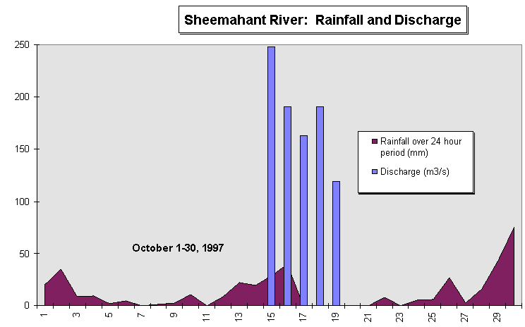
From October 15th to the 19th, flow discharge and rainfall precipitation was measured and the results were recorded (Figure 2). Discharge was measured at the Sheemahant bridge (approximately 5km upstream) by calculating a cross section of the river and using a timed floating object over a predetermined length. These calculations were then multiplied by 0.75 to compensate for the increase in velocity found at the surface. Rainfall was collected from Clear Creek (Machmell drainage) using an AES standard precipitation gauge. When the survey began on October 13th, several days of increasing rain raised water levels enough to quickly flood roads and camp infrastructure. Measurements taken at the peak of the flooding and after the rain stopped showed a slow (4-5 days), but significant decline in river discharge. Observations during the field program as well as the data, though inconclusive, suggest that the Sheemahant River responds dramatically to rainfall events.
Mainstem flooding distributes both water and fish into (and out of) the wetlands throughout the valley bottom. These areas are potentially very productive and sheltered fish habitats. Varying degrees of fish access and stream connectivity, determined mainly by forest road situation and design, as well as beaver activity, affect the degree to which these habitats benefit fish.
Increase in peak flows from logging related activities can increase the amount of fine sediments that are added to the mainstem (Larkin and Slaney, 1996, Beschta 1978, and Anderson, 1971). In the Sheemahant watershed, surrounding steep hills with low gradient wetlands adjacent to the mainstem could be corridors for distribution of sediment into spawning areas, and also affect woody debris and nutrient disbursement. Further studies should be initiated to determine to what degree the fish stocks of the Sheemahant River are being affected by hydrological impacts.
Figure 1. Rainfall and discharge patterns for Sheemahant River during the study period.
Figure 3: Sheemahant River, Reach 1. Both photos taken during flood events on October 16th. Upper photo shows river mouth (Reach 1) with camp infrastructure flooded in the background. Lower photo shows LWD entering Oweekeno Lake just beyond the river mouth.
The mainstem Sheemahant River was not walked extensively due to its large size and flood potential. Field studies were diverted towards associated sidechannels, backchannels, tributaries and wetlands that may provide fish habitat. The study area was defined as Reaches 1 to 6, bounded on the upstream end by cascades that are a partial barrier to anadromous fish. As the study progressed, the area was extended to include wetland habitats to the top of Reach 7. This required little extra effort and allowed sure control data for comparison purposes.
Mainstem fish habitat between the roads and the main river flow was not a direct survey objective, as it is all part of an active floodplain.
Crews walked up and down the mainline roads on the east main (left bank, active mainline) and on the west main (right bank, partly deactivated to old standards). This was to identify tributaries that could be restored in conjunction with road works or by using road access points.
Crews were instructed to traverse the perimeter of each wetland encountered, and describe this habitat subjectively, using maps, diagrams, photos and notes. Inlet and outflow streams were then identified, mapped and surveyed using the FHAP stream data criteria. Fish distribution within the wetland was established by minnow trapping and for electrofishing at strategic points around the wetlands.
Crews gathered site-specific information on both tributary and wetland habitats. Reach descriptions in the stream habitat were on a subsampling basis, determined by a projected length of stream to walk each day.
During the stream survey, subsampling by habitat type (1 in 3 riffles, 1 in 2 glides, all pools) was conducted, according to the criteria outlined in Technical Circular No. 8. Field data recorded was consistent with the FHAP Level I data form, but modified to include more detailed temperature and discharge measurements, as well as stream bank characteristics. Crew members also recorded a fish habitat log, correlated with hip chain measurements, and an accompanying diagram that explained more complex stream configurations and habitats. A photo log was also kept, and all photos were labeled and catalogued for archive purposes.
All crews had 1:20,000 Trim maps, compasses, and aerial photos, and were carefully oriented by truck or helicopter before beginning their surveys. Some crew members had GPS equipment, and these were used for positioning where appropriate. Crews walked from known positions on the map, charting their location by hip chain distances, assisted by laser rangefinder distancing where necessary and appropriate. The progress of each crew was charted on master maps after each day’s work.
Fish capture was conducted primarily in off-channel habitats. As many habitats as possible were sampled, with consideration for the cost-effectiveness of access into difficult locations.
Minnow traps were usually set for 24 hours, but occasionally for 5 hours if it was cost-effective to do so. Electrofishing was not conducted extensively in this system, due mostly to weather constraints, but also as minnow trapping was more effective for the locations sampled (beaver ponds and back channels).
Electrofishing was often used as a training tool, to verify species identification, and to remind crews to check and survey micro habitats. Species identification was frequently checked by the crew supervisor. Microhabitat locations and characteristics for reach trap site were recorded, species and life stage was determined for all fish captured, and fish length recorded to the nearest 5mm for all salmonids.
The first line of quality control was in coordinating field traverses and supervision of all crew members. There was a short training session prior to the start of the field program, when habitat recognition and measurement of stream characteristics was repeatedly practiced and data recorded. At the start of the field program, extra supervisory assistance was given by a roving biologist, who traveled at least one day with each team to answer questions and reinforce field measurements and strategies. Data sheets, field notes, equipment anomalies, etc. were checked daily by each team’s leader and by the senior biologist. Location and extent of field surveys were charted daily and field information generally reconciled with map information. Field surveys were structured so that crews did not overlap, and survey start and end points were flagged in the field.
In the field, every fifth day was a "data day" when crews reviewed their work, assembled data in different formats, completed photo records, checked equipment operation, sent film out for processing, etc. The field information was reviewed and discussed with the project biologist, and checked for anomalies and significant findings.
Since most of the field survey locations were accessed only by helicopter, it was not cost-effective to re-survey the same area by a different crew for quality control purposes. Instead, photo records were kept that were used to re-check interpretations of different habitat types and correlate general observations.
Quality control concern was appropriately directed towards flood events. The Sheemahant watershed is subject to extreme flood events which sometimes obscured stream habitat units. Observations during the field program were that this system can respond very quickly to rainfall events, such that a deluge in the morning can raise the river level as much as 2m by late afternoon. Accordingly, depth and surface velocity measurements were taken at the lower Sheemahant bridge and used to derive discharge, which is then used to qualify the data record. It is not appropriate to precisely correlate measured stream depth, etc. with flood records without more detailed analysis. However, the flood events provided valuable information on the fluvial processes affecting stream habitat, which is a subject in itself.
In fact, the active flood plain of the Sheemahant River extends well beyond the road network in the valley, especially on the left bank. When high rain events caused the river to rise, field crews witnessed road flooding, culverts flowing backwards, beaver dams breeched, etc. Field studies were directed towards tributary habitats that were more visible at this time. Limited mainstem surveys were not appropriate when the river was rising, primarily to the physical difficulties of negotiating the banks of this system, but also due to the bear population which moved off the gravel bars and began moving through the roads and high-level riparian trails, as they became unable to fish. As the river dropped, in-stream barriers and their impact on fish distribution became easier to evaluate, and fish capture efforts were intensified.
The data has been assembled and calculated in two documents. The Volume I - Summary contains summarized data and proposed restoration opportunities. Volume II - Data Appendices contain reproductions of the field sheets, sketch maps of certain areas, rough field notes, as well as detailed fish capture results.
Reach and Reference: keys to the appropriate appendix information, with associated notes and diagrams.
Length: length of the survey that applies to this data set (may be truncated to better define reach and section delineations). Proportions of pools, glides, riffles and cascades are expressed as a percentage of this.
Off-Channel Habitat: The type of off-channel habitat found, and the length of it. Note that some areas had substantial lengths of old channel that were not accessible to fish at all. Lower reaches of tributary habitats were not included in this calculation.
Gradient, water depth, bankfull width: These are expressed as a range of values, as they differ substantially throughout the survey. This information is intended to generally describe how the channel characteristics change from reach to reach.
Substrate: This is expressed as the most frequent category of substrate that is described in the notes.
LWD RATIO: This describes the total length of the survey divided by the number of functional LWD. This figure does not include debris jams that are parallel to the mainstem that are better described as disturbance indicators.
Much of the study area consisted of wetlands, rather than streams, and did not easily fit into the stream survey template normally applied to salmonid habitat evaluation. Accordingly, streams were identified and surveyed where these existed, but additional inspections were carried out to determine peripheral fish habitats in isolated wetlands and within wetland complexes. Volume II contains completed Form 5 data, as well as subjective notes and diagrams for each of the field surveys referenced (Field Reference Code). This volume summarizes that information.
Fish capture was frequently an important part of the field surveys, as the mechanisms for fish passage into some of the wetlands was not clear. During the survey period, the mainstem Sheemahant River was observed flooding over the east main road and flowing backwards through the culverts. Some fish were also distributed in this manner.
Table 1. Summary of fish habitat areas and general field survey approach.
|
Sheema-hant River Reaches |
Fish Habitat Area Surveyed |
Habitat Type and Field Approach |
Field Reference Code |
|
Reach 1 Right bank |
Reach 1 flood plain and tributaries |
The main road was surveyed to locate stream crossing points, and establish the extent of fish habitat from the mainstem. Flooded areas and channels around camp were also inspected. |
GB-50 GB-51 GB-52 GB-53 HP-16 HP-8 |
|
Reaches 1 - 6 to 6 - 1 Right Bank |
Sheemahant West Main road crossings |
The West Main road was walked to locate streams, and then each one was surveyed. The streams in this area have been altered significantly in recent years. |
BR-16 BR-25 GB-41 BR-26 GB-42 GB-43 HP-19 HP-17 |
|
Reaches 1 - 6 to 3 - 1 Left bank |
East Main flooded areas (lower section) |
Walked the East Main road to locate stream crossings, and surveyed each. Wetlands and flooded areas were located and walked to establish inlet and outlet points. Fish capture was conducted. |
BR-17 OC-41 OC-42 OC-43 OC-44 OC-45 OC-46 |
|
Reaches 5 - 3 to 7 Left bank |
East Main fish streams |
There are three significant fish-bearing systems that form a part of complex wetlands. They are each surveyed as streams, and fish capture was conducted. |
GB-44 GB-45 GB-46 GB-47 HP-10 HP-11 |
|
Reaches 6 - 2 to 7 Left bank |
East Main wetlands (upper section) |
Large, identifiable wetlands exist behind this section of the road, adjacent to 21 - 25 km sections. These were walked around their periphery, to locate and survey inlet and outlet streams. Fish capture was conducted. |
BR-18 BR-19 BR-20 BR-21 BR-22 BR-23 BR-24 HP-12 OC-47 OC-48 OC-49 OC-50 |
|
Reach 7 Right bank |
Upper watershed wetlands |
There are three well-defined wetlands at the top of the study area, on the right bank. Their inlet and outlet systems are water control points, rather than streams. Fish capture was conducted, and each area was surveyed around the periphery. |
GB-48 GB-49 HP-13 HP-14 HP-15 |
7.1.1 Reach 1 Flood Plain and Tributaries
7.1.1.1 River Mouth Lake Intrusions
Figure 4: Lower Sheemahant flats in the immediate vicinity of the camp.
Figure 5: Upper photo is Sheemahant River mainstem, Reach 1 section 1 (right bank) adjacent to the camp. Lower photo is same area, further from the mainstem.
Figure 6. Tributary at 3 km, Sheemahant right bank. Photo taken at 1020m, looking downstream toward beaver dam.
Figure 7. Glide habitat in HP-8 stream, near confluence with Sheemahant River, Reach 1-5, right bank.
7.1.2 Sheemahant West Main Road Crossings:
Table 2: Summary of off-channel habitat along the West Main Road. Data refers to Reach 1 of each tributary containing potential fish habitat.
|
Location adjacent mainstem reach, right bank |
Reach 2-4 |
Reach 3-2 |
Reach 5-3 |
Reach 5-3 |
Reach 6-1 |
Reach 6-1 |
|
Field Reference |
HP - 17 |
BR - 16 |
GB - 41 |
GB - 42 |
GB - 43 |
BR - 26 |
|
Survey Length |
1,074 m |
242 m |
555 m |
315 m |
430 m |
337 m |
|
Habitat Types: |
Sidechannel |
Tributaries |
Tributaries |
Tributaries |
Tributaries |
Tributaries |
|
% Pools |
6% |
2% |
1% |
0% |
0% |
2% |
|
% Riffles |
13% |
34% |
10% |
0% |
0% |
0% |
|
% Glides |
81% |
0% |
0% |
0% |
0% |
0% |
|
% Cascades |
— |
64% |
89% |
100% |
100% |
98% |
|
Off-Channel Habitat |
— |
— |
— |
— |
— |
— |
|
Total length |
160 m |
0 |
0 |
0 |
0 |
0 |
|
Type |
Trib (SC) |
SC |
— |
— |
— |
— |
|
Gradient |
0 - 3% |
0 - 10.5% |
8% |
11% |
19% |
0 - 23% |
|
Depth |
.04 - .13m |
.1 - .3m |
.1 - .3m |
.3m |
.35m |
— |
|
Bankfull width |
3.1 - 13.3m |
1.9 - 6.2m |
13.1 - 22m |
3.65m |
15.9m |
3.6 - 9m |
|
Dominant Substrate |
F/G |
G |
C |
C |
C |
C/G |
|
Subdominant Substrate |
F |
C |
G |
G |
B |
— |
|
No. of LWD per distance of stream length |
1 : 23 m |
1 :11 m |
1 : 69 m |
1 : 315 m |
1 :72 m |
1 : 15 m |
|
No. of holding pools per distance of stream length |
0 |
0 |
1 : 555 m |
0 |
0 |
0 |
|
Accessible distance |
2,564m |
242m |
555m |
315m |
430m |
337m |
Figure 8: Tributary at HP-17 at 1,086m, showing debris torrent.
Figure 9. Photo shows 1 of 3 isolated ponds in Reach 2, which were originally gravel borrow pits.
Figure 10: Tributary at BR-16, at 102m, showing log jam and sediment wedge.
7.1.2.3 Adjacent to Reach 5-2 and 5-3
Figure 11: Tributary at GB-41, showing new stream channel flowing over west main road.
Figure 12: Tributary at GB-42, showing stream crossing old west main road.
Figure 13: Tributary at GB-43, downstream of west main road crossing, showing new channel found and 19% gradient.
Figure 14: Tributary at BR-26, showing LWD scour pool in new channel, 49m upstream from mainstem.
7.1.3 East Main Flooded Areas (lower section)
This is an area that has been altered significantly from its natural condition, due to a combination of road construction, upslope logging and river flooding. There are four general areas that provide (or affect) fish habitat:
Results are summarized in this document only for the Kull Creek area (6 km flood plain, 7 km wetland streams), and the 13 km flood plain. Subjective notes and diagrams are found in Volume II for all areas inspected.
7.1.3. Kull Creek and 7 km Wetland
Table 3: Summary of stream habitat characteristics of creeks near Kull Creek outlet and the 7 km Wetland.
|
Location |
Kull Creek |
7 km Wetland |
|||
|
Field Reference |
OC-41 |
OC-44 |
OC-43 |
OC-45 |
OC-46 |
|
Survey Length |
261m |
82m |
277m |
178m |
85m |
|
Habitat Types: |
|||||
|
% Pools |
18% |
0 |
5% |
3% |
0 |
|
% Riffles |
24% |
0 |
0 |
0 |
0 |
|
% Glides |
58% |
0 |
95% |
81% |
100% |
|
% Cascades |
0 |
100% |
0 |
16% |
0 |
|
Off-Channel Habitat |
|||||
|
Total length |
0 |
0 |
0 |
0 |
0 |
|
Type |
- |
- |
- |
- |
- |
|
Gradient |
0-2% |
4% |
1.5% |
0-10% |
0 |
|
Depth |
.17-.50m |
.4-.5m |
.18m |
.24-.83m |
.34-.47m |
|
Bankfull width |
11.8-19.3m |
2m |
2.5m |
2.7-3.4m |
5.4m |
|
Dominant Substrate |
Gravel |
Cobble |
Fines |
Gravel |
Fines |
|
Subdominant Substrate |
Cobble |
Boulder |
Fines |
Fines |
Fines |
|
No. of LWD per distance of stream length |
1:130m |
1:16m |
1:15m |
1:89m |
1:7m |
|
No. of holding pools per distance of stream length |
0 |
0 |
0 |
0 |
0 |
|
Accessible Distance |
261m |
82m |
277m |
178m |
85m |
Figure 15: Kull Creek, Reach 1, right branch (OC-41). Photo taken approximately 100m upstream from Sheemahant confluence.
Figure 16: Creek at 13.2 km (BR-17) showing flood plain area below road crossing.
Table 4: Summary of tributary stream habitats along the East Main Road.
|
Location |
Reach 5 - 3 (Alder Creek) |
Reach 6 - 2 (Blue Hawk Creek) |
Reach 7 (20 km Creek) |
|
Field Reference |
GB - 44 |
GB - 45, 46, 47 |
HP - 9, 10, 11 |
|
Survey Length |
746 m |
770 m |
712 m |
|
Habitat Types: |
— |
— |
— |
|
% Pools |
36% |
2% |
11% |
|
% Riffles |
0% |
54% |
0% |
|
% Glides |
64% |
44% |
20% |
|
% Cascades |
— |
— |
69% |
|
Off-Channel Habitat |
— |
— |
— |
|
Total length |
0 |
0 |
0 |
|
Type |
— |
— |
— |
|
Gradient |
0 - 5% |
0 - 12% |
0 - 12% |
|
Depth |
.45 - 1.65 m |
.03 - .69 m |
.03 - .25 m |
|
Bankfull width |
5.65 - 10 m |
2.2 - 10 m |
1.7 - 3.8 m |
|
Dominant Substrate |
F |
F |
F |
|
Subdominant Substrate |
G |
G/F |
F |
|
No. of LWD per distance of stream length |
1 ; 124 m |
1 : 39 m |
1 : 40 m |
|
No. of holding pools per distance of stream length |
1 : 373 m |
0 |
0 |
|
Length of fish access |
1,000 m |
514 m |
712 m |
Figure 17: Alder Creek, approximately 900m upstream from Sheemahant River confluence.
7.1.4.2 Blue Hawk Creek (16.5 km)
Figure 18: Blue Hawk Creek (16.5 km Creek) downstream of the road crossing.
Figure 19: Cutthroat trout (Oncorhynchus clarkii) and river lamprey (Lampetra ayerisi) captured by electrofishing in Blue Hawk Creek.
Figure 20: 20 km Creek, in ditched portion adjacent to East Main Road.
7.1.5 East Mainline Wetlands (upper section)
Table 5: Summary characteristics of major wetlands along the Sheemahant East Main Road.
|
Location |
21 km wetland |
23 km wetland |
25 km wetland |
|
Survey |
Wetland was walked around its perimeter. |
This wetland was walked around the perimeter by two teams, who met in the middle and traversed across the swamp. Culturally modified trees (CMTs) were noted at the base of the cliffs. |
This wetland was walked around the perimeter by two teams, one along the mainstem Sheemahant and the other along the cliff base. One team traversed back over the centre road. |
|
Road Impacts |
The wetland is situated between the east main road and the toe of the slope. The water is beside the right of way, and visible throughout. |
The wetland is a long, narrow configuration situated between the east main road and the cliff base at the toe of the slope. It is deeper towards the cliffs, and shallower near the road. |
The wetland is in a corner bounded by cliffs on one side, the mainstem Sheemahant on the other, and the east mainline road and 25 km bridge in one corner. It is bisected by an old road. |
|
Water control points |
There is a large beaver dam at one end. Inflow is a dry channel through the old landing. One stream outflow comes through a beaver dam and plugged culvert. Two other culverts cross the road, but there is no significant outflow. |
It has no inflow streams other than groundwater and seepage areas off the cliff base. There are two clear culverts, one blocked culvert, and one with very little outflow. |
Three separate outflow streams flow through beaver dams directly into the Sheemahant River. There are two significant streams feeding this wetland from the hillside. |
|
Fish Access |
No fish access. Several salmonid species were found in the outlet stream, but none above. |
Sticklebacks were found just inside the road culverts, but no salmonids. |
Coho were found inside the beaver pond, as well as in the outlet streams. |
|
Pond Habitat |
This is a shallow pond, with little fish cover. It has a central channel, and shows ground disturbance on one side. |
This wetland is criss-crossed through the centre with many beaver dams, most inactive. There is some deep (> 2m) pool habitat near the cliffs. |
This wetland is bisected by an old road, as well as beaver dams. It appears deep enough for salmonids, and has emergent swamp vegetation. |
|
Approximate size of Fisheries Sensitive Zone (FSZ) |
7.2 ha |
15.5 ha |
15.o ha |
Table 6: Summary of stream habitat characteristics of outflow and tributary creeks near 21 km wetland.
|
Criteria |
|||
|
Field Reference |
OC-47 |
OC-48 |
OC-49 |
|
Survey Length |
112m |
52m |
132m |
|
Habitat Types: |
wetland outflow |
sidehill tributary |
sidehill tributary |
|
% Pools |
19% |
42% |
5% |
|
% Riffles |
0% |
39% |
0% |
|
% Glides |
81% |
19% |
37% |
|
% Cascades |
0% |
0% |
58% |
|
Off-Channel Habitat |
— |
— |
— |
|
Total length |
0 |
0 |
0 |
|
Type |
— |
— |
— |
|
Gradient |
1% |
5% |
14% |
|
Depth |
.12 - .65m |
.15 - .60m |
.07 - .18m |
|
Bankfull width |
6.7 m |
1.5m |
1.5 - 3.7 |
|
Dominant Substrate |
F |
— |
— |
|
Subdominant Substrate |
G |
— |
— |
|
No. of LWD per distance of stream length |
1:56m |
1:2m |
0 |
|
No. of holding pools per distance of stream length |
0 |
0 |
0 |
Figure 21: Wetland (upper) at 21 km, and outflow stream (OC-47) below road crossing (lower).
Table 7: Summary of stream habitat characteristics of outflow and tributary creeks near 23 km wetland.
|
Criteria |
||||
|
Field Reference |
BR-18 |
BR-19 |
BR-20 |
BR-21 |
|
Survey Length |
140m |
52m |
80m |
37m |
|
Habitat Types: |
wetland outflow |
wetland outflow |
sidehill tributary |
sidehill tributary |
|
% Pools |
0% |
4% |
6% |
19% |
|
% Riffles |
17% |
19% |
88% |
41% |
|
% Glides |
79% |
0% |
6% |
0% |
|
% Cascades |
4% |
77% |
0% |
40% |
|
Off-Channel Habitat |
— |
— |
— |
— |
|
Total length |
0 |
0 |
0 |
0 |
|
Type |
— |
— |
— |
— |
|
Gradient |
10% |
7 - 19% |
4% |
7% |
|
Depth |
~ 1m |
.1 - .2m |
.5m |
.53m |
|
Bankfull width |
2 m |
7m |
2 - 3.5m |
.5 - 3m |
|
Dominant Substrate |
F |
C/G |
G/F |
F/G |
|
Subdominant Substrate |
— |
F |
F |
— |
|
No. of LWD per distance of stream length |
1:9m |
1:52m |
1:3m |
1:12m |
|
No. of holding pools per distance of stream length |
0 |
0 |
0 |
0 |
Figure 22: Centre portion of 23km wetland, showing deep pools and inactive beaver dams.
Figure 23: Culturally-modified tree (CMT) near 23 km wetland.
Table 8: Summary of stream habitat characteristics of outflow and tributary creeks near 25km wetland.
|
Criteria |
||
|
Field Reference |
BR-23 |
BR-24 |
|
Survey Length |
152m |
145m |
|
Habitat Types: |
sidehill tributary |
wetland outlet |
|
% Pools |
11% |
58% |
|
% Riffles |
42% |
0% |
|
% Glides |
20% |
42% |
|
% Cascades |
27% |
0% |
|
Off-Channel Habitat |
||
|
Total length |
0 |
0 |
|
Type |
— |
— |
|
Gradient |
0-19% |
0% |
|
Depth |
.1-.2m |
1-1.7m |
|
Bankfull width |
1.7-4.0m |
12.9-16m |
|
Dominant Substrate |
Cobble |
Fines |
|
Subdominant Substrate |
Gravel |
|
|
No. of LWD per distance of stream length |
1:9m |
1:8m |
|
No. of holding pools per distance of stream length |
0m |
1:72m |
|
Accessible Distance |
152m |
145m |
Figure 24: Tributary at BR-23 that flows behind mainline at 25 km bridge.
Figure 25: Beaver dam outlet stream on one end of 25 km wetland, just upstream of 25 km mainline bridge.
7.1.6 Upper Watershed Wetlands
Table 9. Summary characteristics of major wetlands upstream of the 25 km bridge.
|
Location |
26 km wetland |
27 km wetland |
29 km wetland |
|
Survey |
Surveyed all around circumference |
Surveyed all around circumference |
Surveyed all around circumference |
|
Road Impacts |
Road bisects this wetland at one side of the 25 km bridge, and continues behind it along the slope. |
Road is situated at the toe of the slope, very close to the edge of the wetland. |
Road is situated at the toe of the slope, very close to the edge of the wetland. |
|
Water control points |
Two tributary inflows off the sidehill, culverted under the road. Two significant outflows through beaver dams, one upstream of the 25 km bridge, and one downstream. |
Inflows to this wetland are mostly off the sidehill and then over the road surface and into the pond. The only outflow is through flooded woodland to the adjacent 26 km wetland. |
Tributary inflows are minor and flow as runoff over the road, directly off the sidehill. The primary pond outflow is ~ 20m long, and flows directly into the Sheemahant through a beaver dam. There is a second pond outflow, that similarly flows into another beaver pond and then through another dam to the Sheemahant. |
|
Fish Access |
Coho have access to this pond, but they disappear in the shallows closer to the 27 km wetland. |
None to this wetland. There is no access through the flooded woods. |
This wetland is not accessible to salmonids, but has some sticklebacks. |
|
Pond Habitat |
Well established, bounded by flooded woods on one side, and deep enough for salmonids. |
Two beaver lodges in the middle, with potentially deep, stable, cool habitat suitable for salmonids. |
This is a well-established pond, with lily pads and would likely make good salmonid habitat if they had access to it. |
|
Approximate size of total FSZ |
29.6 ha |
3.8 ha |
3.8 ha |
Figure 26: General area of wetland on the right bank 26 - 27 km. Upper photo shows confluence with Sheemahant. Lower photo shows part of large pool habitat inside larger wetland.
Figure 27: Aerial view of 26 - 27 km wetlands.
Figure 28. Ground view of 29 km wetland .
Field Reference: HP-17 (see also Site ID: SM22).
Project Name: West Main bridge removal and bank stabilization.
Location: Sheemahant River, reach 2 / 3 break, right bank.
Impact: There is an old mainline bridge crossing this side channel that will eventually collapse and destabilize the surrounding channel banks. A section of this side channel (called Str #8) already has signs of erosion along the stream banks, reduced habitat complexity and includes impact from a section of road that has been washed out, adding sediment and debris to the channel. Sockeye carcasses were seen in the upper end.
Objectives: To prevent further bank erosion in the side channel and its feeder tributaries, to enhance flow through the side channel, and to complex the habitat for fish rearing and spawning grounds.
Priority: High
Work Plan: Work should be conducted in the following sequence:
Bridge removal and bank stabilization should be completed before LWD removal and adjustment is attempted. This area also requires a site-level riparian assessment, to complement heavy equipment work.
A second phase of this work could potentially involve more extensive restoration and complexing of the side channel. This can be determined after the Level II biological design survey.
Costing: Note that costs quoted are intended to indicate only the general scale of the work. Specific prescriptions will be more fully costed when Level II and on-site assessments are completed.
|
Phase |
Activity |
MOELP Funding |
MOF Funding |
|
Level II surveys |
- Riparian site level assessment, to identify locations where streamside planting may be able to stabilize bank areas that heavy equipment cannot access. - Level II fish habitat assessment( LWD complexing, site details, on entire side channel length) - Engineering survey regarding bridge removal |
$600
$2,000 |
$400 |
|
Construction |
- Bridge removal (or reconstruction) - Riparian planting over 300 m both banks - Stream complexing and LWD removal or adjustment |
$5,000 $10,000 |
$5,000 |
Figure 29: Bridge across side channel to the mainstem Sheemahant (upper) and further upstream on the sidechannel itself (lower photo). Field Reference HP-17.
Field Reference: BR-25
Project Name: Sheemahant Tributary Reconstruction.
Location: Sheemahant River, Reach 6, right bank.
Impact: Sheemahant West Main road is inactive, and the slope and road in this area have all become unstable. The instability has caused re-routing of the stream course, and a loss of in-stream habitat. Fish were seen in the lower part of the north braid (species unknown).
Objectives: Stabilize the entire area, then reroute and confine the channels and complex the stream to recreate fish habitat.
Priority: Low
Support: Fish seen below road in stream, near Sheemahant confluence.
Work Plan: This work is conditional upon heavy equipment access to the site, due to the volume of material, and continuing instability. Work could be conducted in the following sequence:
Costing: Note that costs quoted are intended to indicate only the general scale of the work. Specific prescriptions will be more fully costed when Level II and on-site assessments are completed.
|
Phase |
Activity |
MOELP Funding |
MOF Funding |
|
Level II surveys |
Engineering survey to determine potential, stream gradient adjustment, channels confinement, etc. |
$1,000 |
|
|
Biologist to contribute to site specific design and construction plan to protect existing fish use. |
$1,000 |
||
|
Site level riparian survey, to complement heavy equipment work (rip-rapping) |
$500 |
||
|
Professional assessment to plan for long-term slope and road stability at this point. Development of an access management plan. |
$2,000 |
||
|
Construction |
Excavation and complexing of stream adjacent to Sheemahant |
$20,000 |
|
|
Riparian planting, if appropriate A biological monitor would be required. |
$5,000 |
Figure 30: South channel of disturbed tributary. Upper photo is near road crossing, lower photo is at confluence with mainstem Sheemahant (Reach 6, Section 1).
Figure 31: North channel of disturbed tributary. Upper photo is near road crossing, lower photo is at confluence with mainstem Sheemahant (Reach 6, Section 1). Fish were seen in a pool in this tributary.
Field Reference: GB-43
Project Name: Sheemahant Reach 5 Section 3 Tributary Surveys.
Location: Sheemahant River, reach 5, section 3, right bank.
Impact: There are tributaries along approximately 1 km of the West Main road that drain into a large wetland area with sign of beaver activity. The wetland has several dry channels that connect to the Sheemahant mainstem. Fish appear to utilize the wetland (observed fry), however access is limited. More detailed surveying is required to assess sediment sources and extent of the downslope impact.
Objectives: To connect the wetland to the mainstem Sheemahant in several locations along the right bank, reach 5, section 3.
Priority: Medium
Work Plan: In this case, more specific surveys should be conducted to assess the extent of impact and define limits of fish access / utilization. There has been a fairly large shifting of the slope and contours that requires a different kind or level of analysis.
Costing: Specialist assessment team to continue stream walks and develop more detailed restoration options (2 days, estimated cost $ 5,000, split between MOF and MOELP).
Figure 32: Upper photo is at road crossing, and lower photo is at start of braided area 100m downstream.
Figure 33: Confluence area with mainstem Sheemahant at Reach 5, Section 3 (Field Reference GB-43). Upper photo shows tributary habitat with dry channel. Lower photo shows sockeye spawning area in mainstem Sheemahant River adjacent to the disturbed area.
Field Reference: HP-17 (see also Site ID: SM4)
Project name: Tributary #8 stabilization
Location: Sheemahant River, Right bank, Reach 3, Section 3
Impact: A creek along side of the cut block has had some up-slope instability which has shifted the creek flow from its original course. This creek now has significant unstable banks, woody debris torrents, a shifting stream course and a lack of riparian zone.
Objectives: To stabilize and rehabilitate about 1,300m of stream channel.
Priority: Medium-High
Work Plan: Upslope work should proceed first, as follows:
Costing: Note that costs quoted are intended to indicate only the general scale of the work. Specific prescriptions will be more fully costed when Level II and on-site assessments are completed.
|
Phase |
Activity |
MOELP Funding |
MOF Funding |
|
Level II surveys |
AMP development |
Unknown |
|
|
Engineering survey ( costed as a part of west main rehabilitation). |
Unknown |
||
|
Biologist to look at specific focus area for hand crew, then machine crew. |
$1,000 |
||
|
Site-level riparian assessment |
$ 600 |
||
|
Construction |
Excavation and channel complexing |
$3,000 |
|
|
Riparian zone re-construction (300m both banks) |
$3,000 |
||
|
Road works (additional) |
UK |
Figure 34: Upper photo sows sloughing bank in Stream #8, 1,212m upstream from the mouth. Lower photo shows debris deposit in the same area.
Figure 35: 1:15,000 scale airphoto (1989 series) showing Tributary #8.
Field Reference: BR-16
Project Name: West Main Bridge Removal.
Locations: Sheemahant River, right bank, Reach 3/4 break, 11 km Creek
Impact: This is a Creek crossing located at the bottom of a natural slide area. The creek has shifted; however, the ground has since revegetated and is stabilizing. The bridge crossing also seems stable at this time; however, an access management plan is required to create continued long term stream channel stability. The bridge will eventually deteriorate and take part of the sidehill with it. Evidence of old instability and recent revegetation indicates that this has already occurred in the surrounding area.
Priority: Low
Work Plan: Removing or replacing the bridge is necessarily a heavy equipment job and is completely conditional upon equipment access. If it becomes available, further stream complexing could be considered at that time.
Costing: Note that costs quoted are intended to indicate only the general scale of the work. Specific prescriptions will be more fully costed when Level II and on-site assessments are completed.
|
Phase |
Activity |
MOELP Funding |
MOF Funding |
|
Level II surveys |
1 day, site inspectors |
$1,000 |
|
|
Site-level riparian assessment |
$ 600 |
||
|
Construction |
2 days, excavation to remove works and conduct some stream complexing |
$5,000 |
Figure 36: 11 km Creek (field data, BR-16), showing past instability that has since revegetated.
Field Reference: BR-16
Project Name: Tributary complexing and obstruction removal.
Location: Sheemahant River, right bank, reach 3, section 2 (Stream #9).
Impact: A slope failure occurred leading to blockage of a wood culvert along the Sheemahant road. A large wetland area is not accessible to fish as a result of the blockage. Below the road a good rearing stream exists with observed salmonid utilization in the lower reaches. Accumulation of SWD and sediments have reduced the habitat quality.
Objectives: To enhance habitat complexity in the lower reaches of stream #9, and facilitate fish access to the wetland above the road.
Priority: Medium
Work Plan: This road section seems to have been built along the bottom of an unstable slope and through a small wetland which was probably inhabited by fish at one time. After development of an access management plan, the wood culvert should be cleared or re-designed to ensure fish passage upstream and connect the up-slope wetland. Subsequently, complex the habitat below the road by deepening the channel, deepening pools and addition of LWD complexes.
Costing: Note that costs quoted are intended to indicate only the general scale of the work. Specific prescriptions will be more fully costed when Level II and on-site assessments are completed.
|
Phase |
Activity |
MOELP Funding |
MOF Funding |
|
Level II surveys |
AMP development |
N/A |
|
|
Engineering survey to either redesign culvert or remove it. Determine leave equipment or hand crew approach |
$500 |
||
|
Biological survey to estimate quantity of fish habitat that could be gained (wetland extension) and specific stream works in the tributary. |
$1,000 |
||
|
Construction |
Hand crew to disassemble and adjust LWD. |
$5,000 |
|
|
Excavate to clear, if above is not appropriate, with downstream habitat complexing. |
$2,000 |
Figure 37: Tributary #9 confluence, facing upstream.
Field Reference: OC-45, OC-46
Project Name: 7 km wetland.
Location: Sheemahant River, left bank, reach 2.
Impact: There are several adjacent small wetlands at this location some with an accumulation of LWD from an adjacent cut block. Currently, the downstream sections of the wetlands appear to be excellent rearing habitat, however fish access becomes restricted at the road crossings. Blocked culverts from beaver activity and an accumulation of woody debris are likely causes.
Objectives: To re-design 1.5 to 2 km of road for better long-term performance; to control beaver activity; to maintain beaver ponds and their fish rearing habitat and to extend fish habitat into those ponds above the road.
Priority: High
Work Plan: A section of the road is being lost at 8 km and some reconstruction/redesign is required. The 1.5 km to the south ( between 8 km and Kull Creek crossing) should also be addressed at this time. Fish accessible culverts should be designed and installed for this area. It is also necessary to examine ways to slow accumulation of woody debris at the culvert openings and ensure that downstream of the road, culverts do not limit fish access.
Costing: Not developed, as this is entirely a road design concern to be undertaken by MOF.
Figure 38: Example of wetland habitat at 7 km (upper) and adjacent mainstem habitat near Sheemahant confluence (lower).
Field Reference: OC-41, OC-44
Project Name: Kull Creek stream clearance
Location: Kull Creek, downstream and upstream of the mainline road crossing. Sheemahant River, left bank, Reach 2, Section 1.
Impact: Some degree of up-slope or bank instability has resulted in large LWD jams, especially downstream of the bridge crossing. This has caused some re-routing of the stream channel and may accelerate other instability.
Objectives: To reduce the size of some of the LWD jams in the creek before torrenting takes place.
Priority: High
Work Plan: This is work for a hand crew to loosen and reduce the size of several LWD jams. It requires a wider systematic survey to more precisely locate and quantify the debris and to estimate work time and methods to deal with it. Given the long-term potential for continued instability, this work should be accompanied by a site level riparian assessment to control future LWD inputs and stabilize banks. It may be undertaken by size-selective removal of woody debris, so that LWD inputs can be monitored over a longer period.
There should also be a wider survey undertaken regarding fish access to the wetland near the lower reaches of Kull Creek. This is more appropriately related to current logging practices, but deserves wider consideration.
Costing: Note that costs quoted are intended to indicate only the general scale of the work. Specific prescriptions will be more fully costed when Level II and on-site assessments are completed
|
Phase |
Activity |
MOELP Funding |
MOF Funding |
|
Level II surveys |
Biologist to estimate debris quantity and removal methods |
$500 |
|
|
Construction |
Hand Crew, 10 days to dismantle 2 large jams |
$10,000 |
Figure 39: Kull Creek braids, below bridge crossing. Upper photo shows newly formed debris jams on left braid. Lower photo shows newly formed right braid and contributing LWD.
Field Reference: BR-23, BR-24
Project Name: 25 km Wetland Enhancement.
Location: Sheemahant River, left bank, immediately upstream of the 25 km bridge.
Impact: The culvert closest to the new bridge has a large pool and beaver dam on the stream section immediately down slope of an old access road which restricts fish passage. While fish have access to some of the wetland, the old road has cut off perhaps one third of the pond.
Objectives: To enhance the fish rearing potential of the wetland through channeling, and improve fish access throughout.
Priority: Low
Work Plan: The old road through the center of the wetland is currently inactive and should be properly deactivated by excavating and end-hauling some road material. This would reconnect wetland sections to extend fish habitat.
Costing: Note that costs quoted are intended to indicate only the general scale of the work. Specific prescriptions will be more fully costed when Level II and on-site assessments are completed.
|
Phase |
Activity |
MOELP Funding |
MOF Funding |
|
Level II surveys |
Engineering assessment to estimate materials, excavation scheme. |
$500 |
|
|
Construction |
A biological monitor is required to directly supervise the excavation. Estimate 3 days for excavator and truck |
$5,000 |
Figure 40: 25 km wetland habitat adjacent to old road (upper photo). Lower photo shows aerial view with road just off the frame on the right side.
Field Reference: HP-9
Project Name: 20 km wetland extension
Location: 20 km Creek, Sheemahant River, left bank, Reach 7.
Impact: Mainline road construction may have inhibited fish access, but this is not a complete barrier. It is possible that road construction has created a groundwater - fed backwater which has infrequently become beaver habitat. It now also provides good fish habitat, as far as juvenile salmonids can penetrate.
A small creek coming down from the sidehill adjacent to the wetland has been severely impacted. This is a cut area, where wood debris has been piled. Restoration opportunities for this creek are not apparent; however, enhancing the adjacent wetland could be considered a mitigation project.
Priority: Medium
Work Plan: This work could be conducted independently of road construction. It would involve excavation at one end of the beaver ponds and focus on deepening the ponds and improving fish access. The majority of the wood debris may be removed in order to re-create stream flow. Existing fish habitat must be protected and a more detailed biological design is required.
Costing: Note that costs quoted are intended to indicate only the general scale of the work. Specific prescriptions will be more fully costed when Level II and on-site assessments are completed.
|
Phase |
Activity |
MOELP Funding |
MOF Funding |
|
Level II surveys |
Detailed biological design to decide precise locations and methods for excavation and complexing |
$2,000 |
|
|
Engineering design to contribute, to estimate materials, flow control mechanisms, etc. |
$2,000 |
||
|
Construction |
Excavate and reconstruct rearing pond and complex stream habitat. A biological monitor is requires to protect existing fish habitat |
$15,000 |
Figure 41: Upper photo shows mainline road log culvert providing primary fish access into the wetland. There is ~ 2m elevation difference between the adjacent mainstem and the creek mouth. Lower photo shows J. Johnson looking downstream across tributary inundated with log debris.
Field Reference: GB-45, GB-46, GB-47
Project Name: Blue Hawk Creek wetland extension
Location: Blue Hawk Creek (ungazetted name at 16.5 km on east main), Sheemahant River, left bank, Reach 6, Section 1.
Impact: Old cut block and skid trail on the side of the wetland associated with this creek may have cut off protective rearing area. While this creek now provides diverse and attractive fish habitat, it seems to have suffered some in-filling.
Priority: Medium
Work Plan: This work could potentially be undertaken independently of road reconstruction works. It would involve excavation at one end of the old beaver ponds (now in succession), accessible from an old skid trail. However, existing fish habitat and fish must be protected and a more detailed biological design is required.
Costing: Note that costs quoted are intended to indicate only the general scale of the work. Specific prescriptions will be more fully costed when Level II and on-site assessments are completed.
|
Phase |
Activity |
MOELP Funding |
MOF Funding |
|
Level II surveys |
Detailed biological design to decide precise locations and methods for excavation and complexing |
$2,000 |
|
|
Engineering design to contribute, to estimate materials, flow control mechanisms, etc. |
$2,000 |
||
|
Construction |
Excavate and reconstruct rearing pond and complex stream habitat. A biological monitor is requires to protect existing fish habitat |
$15,000 |
Figure 42: Upper photo shows abandoned beaver pond adjacent to Blue Hawk Creek, proposed for excavation to create fish habitat. Lower photo shows one of the tributaries feeding into the pond area.
Field Reference: GB-44
Project Name: Alder Creek Road Crossing
Location: Alder Creek, 14.5 km, Sheemahant River, left bank, Reach 5, Section 3.
Impact: Alder Creek (ungazetted name) provides complex fish habitat for several species and life stages behind the mainline are well back from the road culverts where the ponds provide attractive fish rearing habitat. This is compromised by the mainline road, near the Sheemahant River mainstem, where periodic flooding of the road and blocked culverts are problematic for both roads and fish.
Priority: Medium
Work Plan: Improve fish access by re-designing the culvert system, and re-design the road to eliminate flooding in this area. This project should be undertaken as a part of new road construction or re-design at this point. The very good fish habitat above the road and mainstem river access should be protected.
Costing: Note that costs quoted are intended to indicate only the general scale of the work. Specific prescriptions will be more fully costed when Level II and on-site assessments are completed.
|
Phase |
Activity |
MOELP Funding |
MOF Funding |
|
Level II surveys |
Road engineering regarding culvert re-design Biologist to contribute |
Unknown |
|
|
Construction |
Reconstruct stream crossing as appropriate. A biological monitor would be requires to protect existing fish habitat and fish passage |
Unknown |
Figure 43: Behind beaver dam No. 3 in upper Alder Creek (upper photo). Alder Creek diversion across Sheemahant mainline, at 14.5 km (lower photo).
Field Reference: BR-22
Project Name: 23 km wetland beaver boxes
Location: 2 km adjacent to mainline, at 23-24 km markers, Sheemahant River, left bank, Reach 7.
Impact: The mainline road has been constructed on the edge of a large wetland that has well defined beaver pond and channel habitats at the toe of the slope. Anadromous fish access does not extend beyond the road culverts; however sticklebacks are present in the ponds. It is known that beaver activity periodically plugs the culverts and causes road maintenance problems. There are several outlet streams coming from this wetland, and none afford unrestricted fish access.
Objectives: To gain fish access under the mainline and into the beaver ponds by clearing one or more road culverts.
Priority: High - Medium
Work Plan: This work can be conducted independently of road construction; however, the "beaver box" technology is at the pilot stage and this is an opportunity to test it further. Work should proceed to put in one box and if it works (less culvert maintenance; fish access into ponds), installation in other locations may be worthwhile. This technique works best where the culvert can be somewhat backwatered, which is also an option in this case.
Costing: Note that costs quoted are intended to indicate only the general scale of the work. Specific prescriptions will be more fully costed when Level II and on-site assessments are completed.
|
Phase |
Activity |
MOELP Funding |
MOF Funding |
|
Level II surveys |
Biological survey to choose a specific crossing site and estimate potential fish habitat to be gained at that site. Engineering design is also required to facilitate positioning regarding culvert and dam and to design the box/culvert configuration. |
$1,000 |
|
|
Construction |
Build the box and drop it in, with replacement culvert |
$3,000 |
Figure 44: One portion of the potential fish habitat to be gained by providing fish access into the 23 km wetland.
Field Reference: GB-49, GB-48, HP-13
Project Name: Upper Sheemahant Road Disturbances to wetland areas
Location: Sheemahant Mainline road above 25 km bridge.
Impact: Silt from the road and adjacent cut block is impacting wetland habitats. Generally, these wetlands are formed by beaver dams and have limited access to Sheemahant River fish. The lower sections can usually be penetrated by juvenile coho salmon; however, this shifts to resident salmonid populations (non - target species) and then to no fish as successive beaver dams cut off further access. While salmonids are not now directly impacted by silt intrusions, there are broader concerns about continuing substrate deterioration and overall road and slope stability.
Priority: Low
Work Plan: Three wetland areas are potentially affected by this. An MOF engineering solution should be sought it to deal with road and slope run-off, and riparian planting may also be conducted in selected areas. Priority areas are:
Costing: Note that costs quoted are intended to indicate only the general scale of the work. Specific prescriptions will be more fully costed when Level II and on-site assessments are completed.
|
Phase |
Activity |
MOELP Funding |
MOF Funding |
|
Level II surveys |
Road engineering survey |
$3,000 |
|
|
Site level riparian survey |
$2,000 |
||
|
Construction |
Culvert installation, riprap (5 locations, for example) |
$8,000 |
|
|
Hydroseeding, riparian planting over 1 km of roadway |
$10,000 |
Figure 45: Wetland at 29 km showing adjacent roadway and cut block (upper photo). Lower photo shows road and slope runoff into wetland habitat.
Field Reference: BR-18
Project Name: 13.2 km Creek Restoration
Location: Mark 13.2 km along Sheemahant East Main road, Sheemahant River, left bank, Reach 5, Section 1.
Impact: Direct logging impact is not documented. The creek experiences extremely swift flows; however it contains approximately 1,800 square meters of spawning habitat which would benefit from a reduction in flow and stream complexing.
Objectives: To create complex fish habitat including pools and in-stream cover. Increase bank stability using riparian planting.
Priority: Medium
Work Plan: This site is within the Sheemahant flood plain, and may be seasonally flooded and may never have coniferous LWD recruitment. However, gradients up to 10% offer an opportunity for pool creation using LWD scour logs. This work could be done using either heavy equipment, a hand crew, or a combination of the two, over approximately 200m of stream channel. This work should also include consideration for improved road re-design that would add some culverts and provide better runoff control. This work would complement the biological design, but does not necessarily have to precede it.
Costing: Note that costs quoted are intended to indicate only the general scale of the work. Specific prescriptions will be more fully costed when Level II and on-site assessments are completed.
|
Phase |
Activity |
MOELP Funding |
MOF Funding |
|
Level II surveys |
Riparian Site survey to address long-term LWD recruitment |
$500 |
|
|
Detailed site assessment to identify specific sites, quantities of LWD, Sources and mechanics of LWD manipulation |
$500 |
||
|
Construction |
LWD placement (1 day) |
$1,000 |
|
|
Planting or thinning; a small area (2 days) |
$2,000 |
Figure 46: Upper photo shows unstable bank, downstream of bridge crossing at 13.2 km Creek. Lower photo shows flood plain near Sheemahant confluence, and lack of LWD recruitment.
Figure 47: Confluence area of 13.2 km Creek with Sheemahant River sidechannel.
9.0 SUMMARY OF RECOMMENDATIONS
The West Main road requires further deactivation in order to protect fish habitat. An appropriate Access Management Plan (AMP) should be developed to determine to what extent heavy equipment access will be available or not. If MOF does not participate further, MOELP should take the initiative to revegetate banks and complex stream habitats in selected areas. Other MOELP work (SM-11, SM-10 and SM-22) is conditional upon prior upslope stabilization.
Unstable upslope areas have impacted fish habitat in terms of bedload movement along the West Main road and along isolated road sections along the east main. Above the 25 km bridge, improved drainage structures would further protect fish habitat.
Fish access to tributary, wetland and other off-channel habitats behind the East Main road is poor in some locations. This is primarily related to beaver activity rather than poor road design. Fish habitat restoration and improvement is based on reducing beaver-related impacts.
Much of the proposed work includes companion studies on site-level riparian assessments. This should be addressed as follow-up work to the current overview level riparian studies.
This study proposes restoration projects totaling at least $165,000, exclusive of any companion work to redesign or rebuild roads in certain areas. Priority projects are those that have the potential to immediately restore affected fish habitat, with the expectation that road work will be continuing in most areas.
Volume I contains summarized information gained during the field surveys and much more detailed data has been gathered. Refer to Volume II and the accompanying maps for more specific information on each site.
Table 10: Summary of proposed fish habitat restoration opportunities for the lower Sheemahant River.
|
Site No. |
Activity |
Additional road work required? |
Total cost for development and rehabilitation |
Fish habitat priority |
|
SM4 |
Remove West Main bridge, stabilize banks and sidechannel |
$ 23,000 |
High |
|
|
SM11 |
West main creek channel stabilization |
$ 29,500 |
Low |
|
|
SM10 |
Wetland access improvement and further stream surveys |
$ 5,000 |
Medium |
|
|
SM22 |
Stabilize and rehabilitate stream channel |
Yes |
$ 7,600 |
Medium-High |
|
SM9 |
West Main bridge removal |
$ 6,600 |
Low |
|
|
SM8 |
Stream complexing and wetland access improvement |
$ 8,500 |
Medium |
|
|
SM7 |
Road redesign for better fish passage |
Yes |
Unknown |
High |
|
SM5 |
Kull Creek stream clearance |
$ 10,500 |
High |
|
|
SM13 |
25 km wetland extension |
$ 5,500 |
Low |
|
|
SM25 |
20 km Creek wetland extension |
$ 19,000 |
Medium |
|
|
SM24 |
16.5 km Creek wetland extension |
$ 19,000 |
Medium |
|
|
SM23 |
14.5 km Creek fish access improvement and culvert improvement |
Yes |
Medium |
|
|
SM26 |
23 km beaver box installation |
Yes |
$ 4,000 |
High-Medium |
|
SM27 |
Road runoff control into wetlands |
Yes |
$ 23,000 |
Low |
|
SM14 |
13.2 km Creek complexing and riparian planting |
$ 4,000 |
Medium |
|
CMT |
Culturally modified tree |
|
FISS |
Fisheries Information and Summary System |
|
FSZ |
Fisheries sensitive zone |
|
MOF |
Ministry of Forests |
Brown, G.W., and J.T. Krygier. 1971. Clearcut logging and sediment production in the Oregon Coast Range. Water Resource. Res. 7 (5): 1189.
Fredriksen, R.L. 1972. Erosion and sedimentation following road construction and timber harvest on unstable soils in three small western Oregon watersheds. U.S.D.A. Forest Service Res.
Johnston, N.T., and P.A. Slaney, 1996. Fish Habitat Assessment Procedure’s Watershed Restoration Technical Circular 8, revised April 1996. Watershed Restoration Program, Ministry of Environment, Lands and Parks, and Ministry of Forests.
Jones, J.A., G.E. Grant. 1994. Peak Flow Responses to Clearcutting and Roads, Western Cascades. Water Resource Research.
Hillaby, J. E. 1998. Sheemahant Watershed Overview Fish Habitat Assessment. prepared under contract to Western Forest Products for Ministry of Environment, Lands and Parks, Williams Lake. FRBC Contract No. CCA-856.
This is an overview map, derived from the 1:50,000 FISS map, that describes fish distribution in the Sheemahant River and its tributaries. Fish distribution information and obstructions are derived from existing FISS information, and augmented by new information gained from this study.
This is a project map, derived from the 1:20,000 TRIM map base. It describes the locations where each team surveyed, in terms of survey commencement and end points. Each of the lines on the map corresponds to data sheets, field diagrams, or other field notes in the Appendices (Volume II). Also noted on these maps are fish capture locations, also detailed in the Appendices.
Map 2 also describes specific locations where potential rehabilitation activities are proposed, and a brief explanation of proposed activities. These are further described in the Summary document (Volume I).