Recreational Fishery
Stock Assessment
1999 Final Report

PHOTO 1. View of
Witney Lake, August 1999
Click image
to view 54K JPG |
|
|
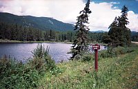
PHOTO 2. Roadside View of
Witney Lake, August 1999
Click image
to view 76K JPG |
|
|
Introduction
| |
TABLE 1. Physical Attributes of Witney Lake.*
| Waterbody identifier |
00822UFRA |
| Water surface area |
7.8 ha. |
| Area above 6 m contour |
7.8 ha. |
| Shoreline perimeter |
1,510 m |
| Maximum depth |
5.0 m |
| Volume |
148,500 m3 |
| Mean depth |
1.9 m |
| Elevation |
1,112 m |
| T.D.S. |
122 mg/L |
| Morphoedaphic index |
64 |
|
|
This report presents the results of a stock assessment
of Witney Lake, completed on August 13, 1999 under
a partnership arrangement between the Ministry of Environment,
Lands and Parks and the Carrier
Sekani Tribal Council (CSTC), with funding obtained
from Fisheries
Renewal B.C. through the Upper Fraser-Nechako
Fisheries Council. Field activities were carried out
by Margo French and Lawrence Ward of the CSTC. Analysis
and reporting of the field results were conducted by the
author. Inquiries pertaining to this report should be directed
to the author at the email and address located at the bottom
of this page. Click here for
directions to Witney Lake.
Witney Lake was initially surveyed in 1981
and was found to contain rainbow trout, lake chub,
and longnose suckers, based on gill net and minnow
trap surveys at that time. The lake was subsequently stocked
in 1982 with rainbow trout fall fry, and has since received
intermittent fall releases.
The stock schedule for Witney Lake mirrors that of Portal
Lake, however the density of fish stocked in Witney
is an order of magnitude less than Portal, at 320 per hectare.
A follow-up survey was conducted in 1985 (Philip)
to investigate the status of the stocked fishery and to
resample certain biophysical attributes initially measured
during the 1981 survey. However, time constraints precluded
the deployment of gill nets and minnow traps, so the crew
engaged in 30 minutes of angling as an alternate sample
technique. No fish were captured using this method.
Since the 1985 survey, a variety of stocking alternatives
(i.e. fall fry vs. yearlings, annual vs. alternate year
stock schedules) have been employed on Witney Lake. To date,
these alternatives had not been systematically evaluated.
Witney Lake was therefore assigned a high priority for assessment
in 1999.

Methods
| |

FIGURE 1. Location of Witney
Lake gill net sets, August 11 to 13, 1999. Click
image to view full bathymetric map.
Click image to view 26K GIF |
|
An experimental, 91.2m sinking monofilament gill net was
set in Witney Lake on August 11, 1999 according to the methods
specified in the Resource Inventory Committee document Fish
Collection Methods and Standards. The net was deployed
at 1:45 PM and retrieved August 12 at 11:40 AM. Only one
fish was captured after this period, so the net was redeployed
12:45 PM at a different site (Figure
1). This second net set was retrieved on August 13 at
10:00 AM, for a total combined soak time of 43.17 hrs.
Set 1 was positioned from the north shore and extended
in a N-S orientation, to an anchor depth of 6.75 m. Set
2 was positioned off the southwest shore and extended in
a NNE orientation, south of the first set. The second set
ranged in depth from the surface to approximately 7 m. The
depths noted by the field crew in 1999 were deeper than
the maximum depth reported for the lake in 1981. This anomoly
may be attributable to a deepening of the lake since the
original survey date, or to measurement error in 1999. No
reference was made to the benchmark established in 1981,
which was located 2.5 m above the water surface at that
time.
All trout collected were sampled for fork length, weight,
sex, maturity, and stomach contents. The general condition
of the fish sampled was also recorded. Scale
samples were collected for age structure analysis. This
analysis was performed by Darlene
Gillespie of TimeMark Consulting Ltd. (Nanaimo, B.C.).
Water temperature and a Secchi disk reading were also reported.
Results and Discussion
| |
TABLE 2. Physical attributes of rainbow
trout sampled in
Witney Lake, August 13, 1999.
| Sample No. |
Age |
Length
(mm) |
Weight
(g) |
Condition |
Maturity |
Sex |
Stomach
Contents |
| 1 |
4 |
310 |
275 |
0.92 |
Maturing |
M |
Empty |
| 2 |
6 |
472 |
980 |
0.93 |
Maturing |
F |
Dragonfly |
| 3 |
4 |
370 |
500 |
0.99 |
Maturing |
M |
Aquatic insects |
|
|
|
CATCH SUMMARY
The combined net catch yielded 3 rainbow trout (Table
2), 63 longnose suckers, 6 burbot, and 3
lake chub. The catch per unit effort (CPUE) was 0.07
rainbow trout per net-hour.
The low catch rate for Witney Lake rainbow trout is not
surprising, considering that only 2,500 fall fry were stocked
in each of the last three stocking events, and that prior
to the 1998 fall stocking the lake was last stocked in 1995.
The combination of low stocking rates, natural and fishing
mortality of the now four-year-old 1995 cohort, and the
co-occurence of burbot (a piscivorous species) are likely
responsible for the low catch rates recorded. The absence
of yearlings (i.e. those stocked in 1998) may be attributable
to their slow growth, thereby being too small to recruit
to the sampling gear.
Management Recommendations
| |
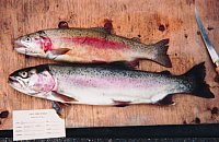
PHOTO 3. Rainbow trout
captured in Witney Lake, August 1999.
Click image to view 75K JPG |
|
With only 3 fish sampled in 1999, and none captured in
1985, there is little data available on which to base management
recommendations for the Witney Lake fishery. The fact that
6-year-old fish up to 980 g exist in Witney suggests that
growth is sufficient, but not extraordinary, to support
recreational fishing. Whether these fish constitute hatchery
stock or are of wild origin is unknown, however the lack
of younger age classes in the sample suggests that natural
recruitment is low to negligible.
Since the gill net catch per unit effort in 1999 was very
low, it is reasonable to assume that current angling success
is poor. The sporadic stock schedule that has occurred to
date may be insufficient to provide enough fish for a successful
angling experience on Witney Lake, especially considering
that the lake is located immediately off Highway 16 in Mt.
Robson Provincial Park, where frequent use by anglers would
be expected. In order to develop the most appropriate management
strategy for Witney Lake, the following actions are recommended:
-
data on current angling pressure (anecdotal or otherwise)
should be obtained;
-
stocking rates should remain consistent for at least
a four year period in order to evaluate stock rates
and fishery performance; and
-
a followup assessment, targeting adults only, should
be completed once consistent stocking has been implemented
over a four year period
In the interim, the Ministry will continue to stock 2,500
fall fry in alternate years into Witney Lake. A repeat of
this assessment should then be conducted in August 2001,
at which time the 1998 cohort will be available to the sample.
Sampling during this time will provide data on the relative
density and mean growth rate of trout that have been stocked
at a consistent level. This data can then be used as the
basis to make decisions regarding stocking options and/or
harvest rates should they be deemed necessary.
Literature Cited
Miller, C. and B. Tupniak. 1981. Witney
Lake : Lake Survey Data. Report prepared for the Fisheries
Branch, Ministry of Environment. Prince George.
Philip, D.F. 1986. Witney Lake - Stock Assessment
August 13,14, 1985. Report prepared for the Fisheries Branch,
Ministry of Environment. Prince George.
Appendix 1.
For More Information:
Contact :Ted
Zimmerman
Sr. Fisheries Biologist, Omineca sub-Region
Prince George, B.C.
250-565-6852 |