
Roads & Roadless Areas in British Columbia
While roads serve the interests of the public, First Nations, and industries, they are also one of the most widespread forms of landscape change1. Roads can threaten biological diversity and ecosystem health through habitat loss and fragmentation, expanding development, spread of invasive species and increasing human-wildlife interactions—for example animal mortality from collisions with vehicles1. This indicator reports on the amount and distribution of roads and roadless areas in British Columbia.
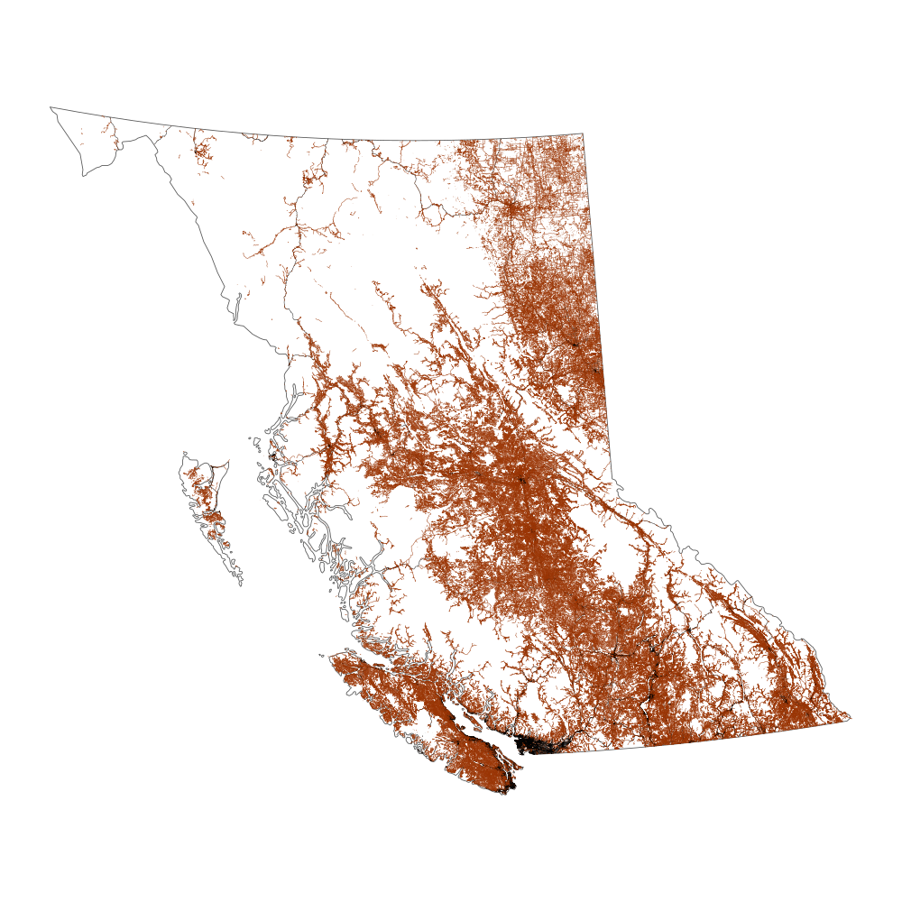
- British Columbia has approximately 719,000 kilometres of roads. Roads include all paved roads and all unpaved roads and trails that allow motorized vehicle use.
- Unpaved roads make up 92 percent of the roads in British Columbia. B.C. has a long history of natural resource use resulting in this large, unpaved road network2.
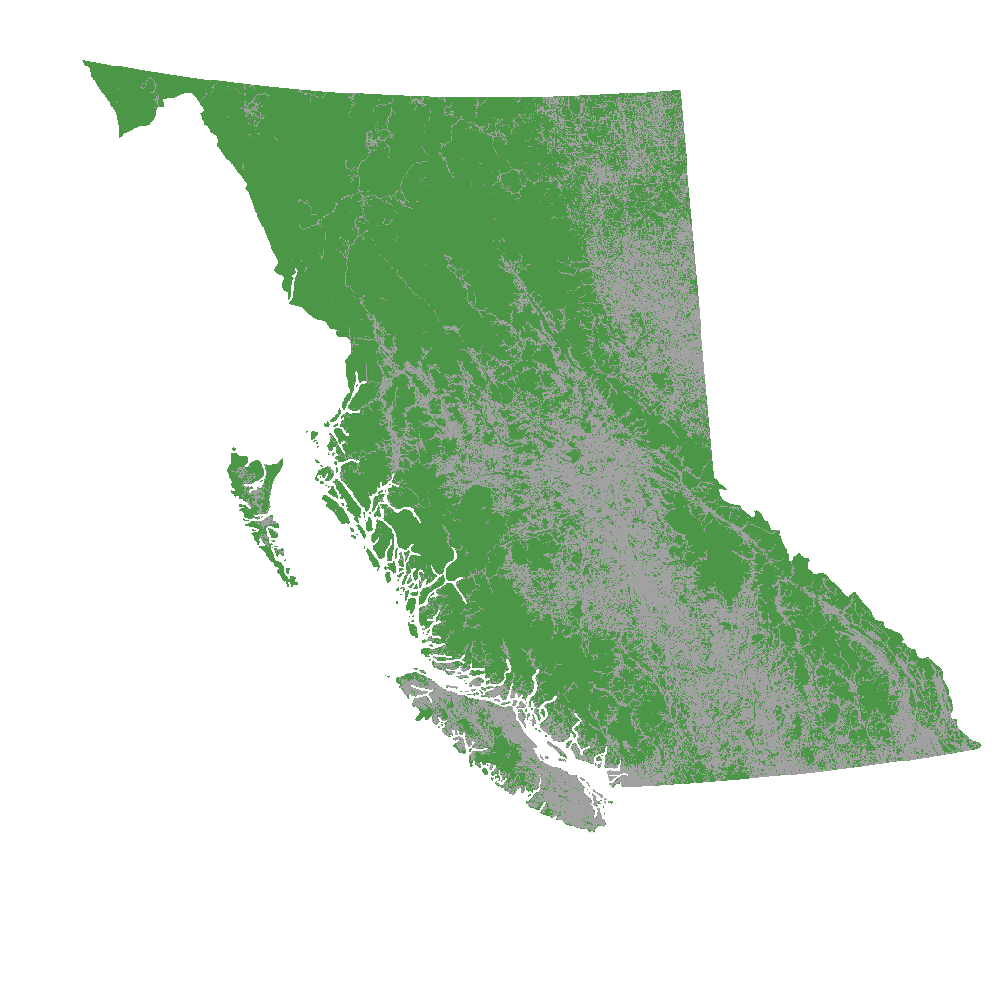
- Two thirds of British Columbia's landbase is roadless. The amount and distribution of roadless area—areas further than 500 metres from a road—varies considerably across British Columbia.
Large areas that are not influenced by roads or other landscape disturbances provide benefits and opportunities for British Columbia and British Columbians. These large, roadless—or intact—areas provide conservation benefits, for example providing habitat for species such as grizzly bear, maintaining ecosystem services, such as water availability and flood control, and supporting adaptation to climate change. They also provide economic, recreational and wilderness opportunities.
B.C. Digital Road Atlas
The Digital Road Atlas is the best available single source of road data for the Province of B.C.
The B.C. Government is working toward updating and integrating all resource roads into this single comprehensive database.
Explore the B.C. Digital Road Atlas to learn more about roads in B.C.
Roads in B.C.
- British Columbia has approximately 719,000 kilometres of roads, when including all road types that allow motorized vehicle use.
- Unpaved roads—which include all seasonal, loose and rough surfaced roads—contribute the most (92%) to the total length of roads in B.C.

Roadless Areas in B.C.
- Sixty-six percent—or approximately 62,600,000 hectares—of British Columbia's landbase is roadless, defined as more than 500 metres from a road.

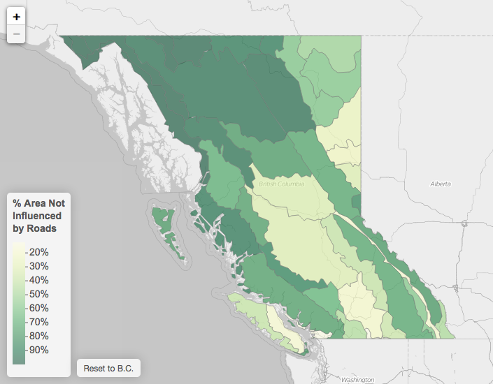
Roadless Areas within B.C.'s Ecoregions
- The amount and distribution of roadless areas vary considerably across B.C. Twenty seven of the 43 terrestrial ecoregions in B.C. are more than 50 percent roadless, while 6 ecoregions have less than 25 percent roadless area.
- As expected, ecoregions with high population densities, and hence larger road networks, have the lowest amounts of remaining roadless area. For example, the Lower Mainland, Georgia-Puget Basin and Okanagan Highland ecoregions each have 13 percent roadless area.
EXPLORE: The interactive map below displays the percent roadless area in B.C.'s ecoregions. Click or tap on individual ecoregions to see more detailed charts and maps for each ecoregion.
Methods
This indicator is based on the B.C. Digital Road Atlas, the best available single source of road data for British Columbia (accessed on May 1st, 2018). All paved roads and unpaved roads and trails that allow motorized vehicle use—as detailed in the Digital Road Atlas Data Dictionary—were included in the analysis. Some road features available in the Digital Road Atlas were excluded, including non-roads (ferry routes, proposed roads, pedestrian only roads, non-motorized trails and water access routes) and non-active roads (decommissioned and overgrown roads). The indicator presents a coarse-scale snapshot of the amount and distribution of roads in British Columbia—data completeness, data quality, road condition or intensity of road use were not evaluated. Roadless areas were determined by applying a 500 metre buffer on either side of all roads. A 500 metre buffer is a conservative value for determining influence and has been defined as the minimum
The R code for repeating the analysis and data visualizations presented on this page is available on GitHub.
References and Other Useful Links
- B.C. Digital Road Atlas
- Biodiversity B.C.
- 1Trombulak, S.C. and C.A. Frissell. 2000. Review of ecological effects of roads on terrestrial and aquatic communities. Conservation Biology. 14: 18-30. DOI: 10.1046/j.1523-1739.2000.99084.x
- 2B.C. Forest Practices Board. 2015. Access Management and Resource Roads: 2015 Update. FPB/SR/49.
- 3Lee, P.G., M. Hanneman, J.D. Gysbers, R. Cheng and W. Smith. 2010. Atlas of Canada’s Intact Forest Landscapes. Edmonton, Alberta: Global Forest Watch Canada 10th Anniversary Publication #1. 74 pp.
- 4Ministry of Environment. 2007. Environmental Trends in British Columbia: 2007. State of Environment Reporting, Ministry of Environment, British Columbia, Canada.
Data
*By accessing these datasets, you agree to the licence associated with each file, as indicated in parentheses below.
Download a printable version of this indicator (PDF, 3.3MB)
Updated May 2018
Suggested Citation: Environmental Reporting BC. 2018. Roads & Roadless Areas in British Columbia. State of Environment Reporting, Ministry of Environment and Climate Change Strategy, British Columbia, Canada.
