An Aquifer Classification System for Ground Water Management in British Columbia
- Abstract
- Introduction
- System Development
- Classification System
- Delineating Aquifer Boundaries
- Results and Discussions
- Relationship between Aquifer Class and Ranking Value
- Uses of the Aquifer Classification System
- Conclusions and Recommendations
- Acknowledgements
- References
R. Kreye1, K. Ronneseth and M. Wei
Ministry of Environment
Water Protection & Sustainability Branch
Province of British Columbia
Abstract
A map-based aquifer classification system has been developed to support ground water management in the Province of British Columbia. The system classifies aquifers on the basis of their level of development and vulnerability to contamination and provides ranking values for aquifers using hydrogeologic and water use criteria. Application of the system leads to the development of an aquifer inventory. The classification system is being applied to selected areas in the Fraser River Basin. To date, a total of 153 aquifers have been identified and classified. Results include: 132 aquifers are used for drinking water, 9 aquifers are found to be heavily developed and highly vulnerable to contamination, and 13 aquifers have documented health-risk related quality concerns.
Introduction
Ground water is often overlooked in context of British Columbia's abundant surface water resource. Ground water supplies approximately 25% of the total municipal drinking-water demand in the province, excluding Victoria and Vancouver, and is often the only available or economically viable high quality potable water source for domestic use (B.C. Environment, 1994). It is of vital economic importance to agricultural and industrial users, and provides an unequaled high volume and high quality water source for numerous fish hatchery operations. With increasing demand and reliance on ground water from a growing population comes the need to increase efforts to protect and manage the resource. Incidences of water quality problems in local and regional aquifers are becoming well documented (B. C. Environment, 1993a; B. C. Environment,1994). However, the information currently available to managers, planners and stakeholders is primarily in raw data form (i.e. well records, water chemistry), or isolated studies in specific areas. There is a need to compile the ground water data into information to enable more effective management decision-making regarding the resource. As well, a method of identifying and prioritizing aquifers for different types of management attention is becoming essential in an era of limiting budget resources. To provide a means of facilitating more systematic management, an aquifer classification system for ground water management in British Columbia has been developed. The primary objectives of the system are to: (1) provide a framework to direct aquifer mapping and assessment, (2) provide a method to prioritize management, protection and remedial efforts, (3) to build an inventory of the aquifers in the province and (4) to increase public knowledge and understanding of the resource. This paper presents the aquifer classification system and summarizes the ongoing results of its application to the Fraser River Basin in British Columbia.
System Development
Classification systems are common tools within resources management and are used in a wide range of roles. This is also true for ground water, as a review of ground water (aquifer) classification systems developed or in use in North American jurisdictions revealed. There is currently no generic ground water classification model that can be followed, hence classification systems are developed specific either to the objectives and needs of the jurisdiction or to characterize the technical aspects of the resource. The most common types of classification systems are either tied to legislation and are regulatory in nature (e.g.. various U.S.A. state classification systems, see Magnuson, 1983),or are directed at technical aspects of ground water management such as vulnerability assessments (i.e. AVI (Van Stempvoort et al, 1992) and DRASTIC (Aller et al, 1987)). None of the systems reviewed appeared adaptable to the Ministry's objectives and unique data.
In developing the classification system a number of factors had to be considered. The system had to support the Water Management Program's direction toward ground water allocation, planning and protection.2 It needed to be efficient and cost-effective and take advantage of existing water well and water chemistry data sources without requiring expensive drilling and sampling programs. At the technical level, it had to be responsive to the wide variation in hydrogeologic conditions and resource usage across the province and function within the constraints and limitations of the existing data.
Classification System
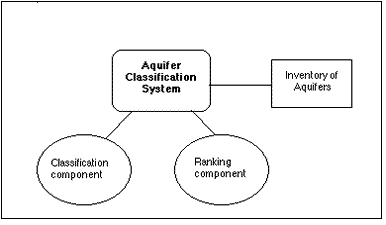
The aquifer classification system has two components:
- a classification component to categorize aquifers based on their current level of development, (use) and vulnerability to contamination, and
- a ranking component to indicate the relative importance of an aquifer.
The application of the classification system on a province-wide basis would provide a comprehensive inventory of aquifers (Figure 1).Classification and ranking values are determined for aquifers as a whole, and not for parts of aquifers.
Figure 1. Structure of Classification System
Classification Component
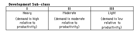
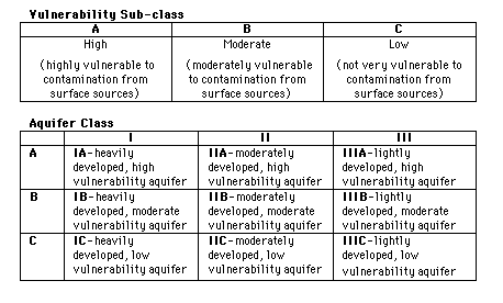
The classification component categorizes aquifers according to level of development and vulnerability to contamination: Level of Development and Vulnerability subclasses are designated. The composite of these two subclasses is the Aquifer Class (Table 1).
Development subclass: the level of development of an aquifer is determined by assessing demand verses the aquifer's yield or productivity. A high (I), moderate (II), or low (III) level of development can be designated.
Vulnerability subclass: the vulnerability of an aquifer to contamination from surface sources is assessed based on: type, thickness and extent of geologic materials overlying the aquifer, depth to water (or top of confined aquifers), and the type of aquifer materials. A high (A),moderate (B), or low (C) vulnerability can be designated.
Aquifer Class: the combination of the three development and three vulnerability subclasses results in nine aquifer classes (Table 1). For example, a class IA aquifer would be heavily developed with high vulnerability to contamination, while a IIIC would be lightly developed with low vulnerability.
Table 1. Classification Component
Ranking Component
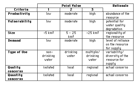
A numerical measure of an aquifer's priority is provided by the aquifer's ranking value. The ranking value is determined by summing the point values for each of the following hydrogeologic and water use criteria: productivity, size, vulnerability, demand, type of use, quality concerns (that have health risk implications), and quantity concerns. (Table 2). All criteria have arbitrarily been assigned equal weight. Values range from a minimum of "1" to a maximum of "3", except for quality and quantity concerns which are assigned a minimum of "0" if concerns are not evident. Possible ranking scores range from a low of 5 to a high of 21; the higher the ranking score, the greater the aquifer's priority.
Table 2. Ranking Component
The classification system is map-based with aquifers delineated at a scale of 1:50,000 (the classification system is only being applied in areas with well location mapping). An inventory database containing the attributes of each aquifer is built as aquifers are identified and classified. The maps and database can be readily incorporated into a geographical information system (GIS). Operationally, the system is office-derived using existing and readily available data sources. These include well records provided by well drillers (approximately 70,000 available across the province), published geologic mapping, and Ministry and consultants reports. Data availability and reliability constrain how technically rigorous the assessments can be (e.g.. while transmissivity values provide the basis for assessing aquifer productivity, these values are rarely available; productivity can alternatively be assessed using typical well yields, type of well use, aquifer materials and other indicators.) The data limitations are important to note as class designations strive for reasonable assessments based on the available data, not rigorous determinations. Given the broader management objectives of the system and the operational and data constraints, this approach is both acceptable and appropriate. It is acknowledged that the classification and ranking value of an aquifer is time dependent and could change with updated information.
Delineating Aquifer Boundaries
One of the primary tasks of classification is identification of an aquifer and delineation of its boundaries. As classification is based on existing information, aquifer boundaries range from reasonable assessments (where detailed information is available) to general approximations (scarce information availability). Only those aquifers which have sufficient ground water development are delineated and classified. In the cases where aquifers cannot be fully delineated, especially confined unconsolidated aquifers and bedrock aquifers, boundaries are defined by the area of ground water development. Aquifers with areas less than 1 km2 are generally not mapped. Guidelines for determining level of development, vulnerability to contamination and ranking values are detailed in Kreye and Wei (1994).
Results and Discussion
To date, 153 aquifers in the Fraser River Basin have been identified and classified (Kreye and Wei, 1994; Ronneseth, 1994). One hundred and thirty-two(86%) of these aquifers are used for drinking water. The remaining aquifers(14%), located mostly near Vancouver where drinking water is supplied by the Greater Vancouver Water District, are used for industrial and/or irrigation purposes. Aquifer classification has been completed for 15, 1:50,000 scale NTS map sheets (Figure 2). As an example, part of the Prince George map sheet (93G/15) is shown in Figure 3.
Figure 2. Progress of aquifer classification in the Fraser River Basin. The light grey areas are NTS map areas with water well location mapping. The dark grey areas represent completed map sheet areas.
Figure 3. Sample of map-based classification from Prince George map sheet. Stippled areas represent unconsolidated aquifers; hatched areas are bedrock aquifers. Each aquifer is labeled with name, classification and ranking value(after Ronneseth, 1994). Map has been reduced to 1:125,000 to fit to page.
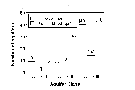
Figure 4 shows the distribution of the identified aquifers by class. There are nine IA and six IC aquifers, for a total of fifteen heavily developed aquifers (10% of aquifers identified). Six of the IA aquifers supply drinking water to major communities: Hopington, Langley, Abbotsford, and Chilliwack in the Lower Fraser Valley and Merritt and Prince George in the interior of the province; the other three IA and six IC aquifers supply domestic water to other communities and individual households. No IB aquifers have been identified. Forty-three aquifers (28%) are identified as moderately developed, including 7 IIA, 8 IIB and 28 IIC aquifers. The remaining ninety-five aquifers (62%) are classified as lightly developed, with 40 IIIA, 14 IIIB and 41 IIIC aquifers.
Figure 4. Distribution of Aquifers by Class
Grouping the aquifers by vulnerability subclass, fifty-six aquifers (37%) are highly vulnerable (A) to contamination. Forty of these are used for drinking water supply. Many highly vulnerable aquifers are unconfined sand and gravel aquifers associated with river valley deposits. Twenty-two aquifers (14%) are moderately vulnerable (B); all but two supply drinking water. The remaining seventy-five aquifers (49%) were classified as having low vulnerability(C).
Unconsolidated aquifers currently comprise 81% of the total inventory while 19% are fractured bedrock aquifers. The high percentage of unconsolidated aquifers identified reflects the association between population distributions and river valley locations where aquifers are typically developed in sand and gravel deposits. Bedrock aquifers in the surveyed area are generally found on valley sides or in upland and plateau areas where the population is more sparse. One bedrock aquifer located in the interior of the province south of Prince George,comprising basaltic lava flows, is greater than 1660 km2 in area.
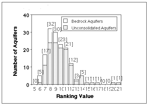
Figure 5 shows the distribution of the ranking values of the identified aquifers. Ranking values for the 153 aquifers ranged from a high of 21 to a low of 6. The right-skewed distribution is attributable to the quality/quantity concerns in aquifers with high ranking values. Aquifers with ranking values greater than 14 are all IA aquifers (Hopington (21), Abbotsford (20), Langley/Brookswood (17), Merritt (16) and Nechako River aquifer at Prince George (15). These 5 aquifers are unconsolidated sand and gravel aquifers and all but the Nechako River aquifer have documented quality and/or quantity concerns. Bedrock aquifers have relatively lower ranking values, reflecting generally lower productivity, lower demand and few documented quality/quantity issues. Ranking values of the fractured bedrock aquifers were primarily in the 6 to 9 range.
Figure 5. Distribution of Aquifers by Ranking Value
Only fifteen of the 153 aquifers have documented quantity and/or health-risk related quality concerns. Four aquifers have reported quantity concerns and thirteen have reported quality concerns; two aquifers have both. Nitrate is the main quality concern reported for five of these aquifers. Regional nitrate concerns are reported for aquifers at Abbotsford, Hopington and Langley/Brookswood. Other reported regional or local quality concerns include occurrences of: elevated fluoride levels, tetra-and penta-chloro-phenols, arsenic, nitrates and leachate. Regional quantity concerns (declining water levels) have been documented in the aquifer at Hopington.
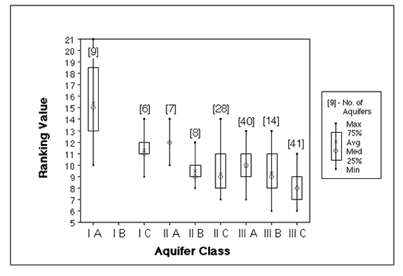
Relationship Between Aquifer Class and Ranking Value
Aquifer class and ranking value are related in that, together, they provide both descriptive and quantitative information about the aquifer. Box plots of ranking values for each aquifer class are plotted to investigate how the ranking value and aquifer class may be related (Figure 6). The box plots show the range of ranking values, the average and median values and the 25 and 75 percentile ranking value for each aquifer class. Although there is a large spread of ranking values for some of the aquifer classes (e.g. the range of ranking values for IA aquifers is 11 points), overall, ranking values generally increase with increasing levels of development and increasing vulnerability. This occurs because factors considered in the classification component (demand, productivity and vulnerability) also appear in the ranking component.
Figure 6. Relationship Between Aquifer Class and Ranking Value
Uses of the Aquifer Classification System
Designed primarily for use within the Water Management Program, the classification system can serve a variety of functions. A primary benefit is the accumulation of an aquifer inventory which is critical for comprehensive ground water management. It is important to have knowledge of the number of aquifers to be managed and their general geographical, physical and hydrologic characteristics. The classification system can guide in planning of Program monitoring activities such as observation well and ambient water quality networks. The system can also provide a method for identifying aquifers that require more detailed assessment, including hydrogeologic mapping, modelling and identification of recharge and discharge areas of aquifers. Operational policies for hydrologic assessment could be developed for individual aquifer classes. For instance detailed hydrogeologic mapping and ground water flow modelling may be initiated for heavily developed aquifers (IA, IB, IC) to assist in allocation planning. Water quality surveys, vulnerability mapping and monitoring programs could be initiated for high vulnerability aquifers that have a moderate to heavy level of development (IA, IIA).
The classification system could also play an important role in the delineation of ground water management areas (GWMAs) under proposed ground water legislation. Current proposals include more intensive ground water management in areas of recognized quality/quantity concerns through GWMAs (B.C. Environment, 1993b). Of the 153 aquifers identified, 10% have quality/quantity concerns and 10% are considered heavily developed and may benefit from more intensive management through GWMAs. The delineated aquifer boundaries provide a starting place to delineate the boundaries of the GWMAs (which may also incorporate watershed and land administrative boundaries). This provides decision makers with the potential size of GWMAs and identifies where they may possibly conflict with the management of other resources.
Though this classification system has been designed primarily for in-house use within the Water Management Program, the information it generates will benefit others. It provides managers, planners and stakeholders with interpreted ground water information (not raw data) that will support decision-making in regional resources inventory and planning processes in B.C. (e.g. Commission on Resource and Environment (CORE); Land Resource Management Plans (LRMPs); and 1:50,000 scale B.C. Provincial Watershed/Waterbody Atlas Project). In addition, the classification system produces information which can be a valuable educational tool to promote understanding and awareness of the ground water resource.
Conclusions and Recommendations
The application of the aquifer classification system to the Fraser River Basin has provided a base of information which helps further define the classification system and its potential role in ground water management in the province. As well, it has significantly improved knowledge of the characteristics of aquifers and their use in the Fraser River Basin.
Further work may be required to refine the vulnerability methodology. The low number of moderately vulnerable aquifers identified to date suggests that the result is either due to the unique geology of the surveyed area or the method for assessing vulnerability may not be sufficiently refined. The classification and delineation of bedrock aquifers will require further refinement due to their complex hydrogeology.
The application of the classification system to geographic areas outside of the Fraser River Basin should be undertaken. The Gulf Islands and east coast of Vancouver Island, the Okanagan Valley and the Peace River Basin are areas to consider.
Operational policies for ground water assessment activities should be developed for the different aquifer classes; including types of investigations, monitoring programs and other initiatives that support management. The role of the classification system and how it is integrated with other environmental and resource management activities should be further defined.
Finally, the uses and presentation of the information resulting from classification should be explored. Maps and summary information could be made available to the public and stakeholders to raise awareness of the resource.
Acknowledgements
We thank S. Sersli of Environment Canada and J. Wood of B. C. Environment for GIS and technical support. Aquifer classification in the Fraser River Basin is currently being funded by Environment Canada, Transboundary Waters through the Fraser River Action Plan. We are also grateful to A. P. Kohut, Ground Water Section, Hydrology Branch for providing useful comments to this paper.
References
Aller, L., T. Bennet, J. Lehr, R. Petty, and G. Hackett, 1987. DRASTIC: A Standardized System for Evaluating Ground Water Pollution Potential Using Hydrogeologic Settings. National Water Well Association, Dublin,Ohio/EPA, Ada, Oklahoma. EPA-600/2-87-035.
B.C. Environment, 1994. Ground Water Resources of British Columbia. Ministry of Environment, Lands and Parks and Environment Canada. Victoria, British Columbia.
B.C. Environment, 1993a. State of the Environment Report for British Columbia. Ministry of Environment, Lands and Parks and Environment Canada. Victoria, British Columbia. 127 pp.
B.C. Environment, 1993b. Stewardship of the Water of British Columbia. 1- Ground Water Management. Ministry of Environment, Lands and Parks. Victoria, British Columbia. 15pp.
Kreye, R., and M. Wei, 1994. A Proposed Aquifer Classification System for Ground Water Management in British Columbia. Ministry of Environment, Lands and Parks, Water Management Division. Victoria, British Columbia. 68pp.,7 maps.
Magnuson, P.L., 1983. The Uses of Different Kinds of Aquifers. Workshop on Ground Water Resources and Contamination in the United States, Washington, D.C.. Report No. 83-12. p. 151-171.
Ronneseth, K., 1994. Classification of Aquifers in the Fraser River Basin (Draft Report). Ministry of Environment, Lands and Parks, Water Management Division. Victoria, British Columbia. 23pp., 8 maps.
Van Stempvoort, D., L. Ewert, L. Wassenaar, 1992. AVI: A Method for Ground Water Protection Mapping in the Prairie Provinces of Canada. Prairie Provinces Water Board, Regina, Saskatchewan.
___________________________
1 University of Victoria, Department of Geography, Cooperative Education Program.
2 There is currently no ground water legislation in British Columbia, though revision of the province's Water Act in the near future is expected to include it.
|