 Figure
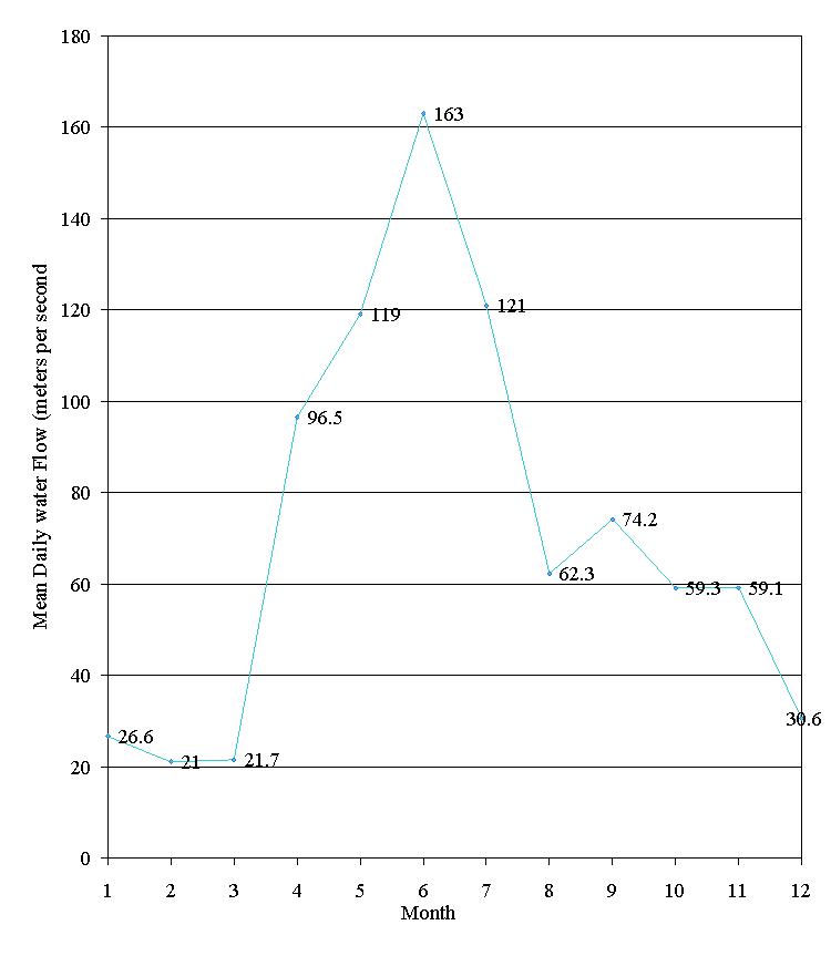
2. The hydrograph for Bowron River describes the water flow at Box Canyon for
1996. The water flow peaked in August and was low in February. (Water Survey
of Canada, 1997)
Figure
2. The hydrograph for Bowron River describes the water flow at Box Canyon for
1996. The water flow peaked in August and was low in February. (Water Survey
of Canada, 1997)
Overview Report
Fish Habitat Assessment Procedure
Upper Bowron River Watershed
FRBC Project 97CAR1
Prepared for
West Fraser Mills Ltd.
P.O. Box 6000
Quesnel, BC, V2J 3J5
by
Guy Thorburn, B.Sc., and Roberta Pedersen, M.Sc., R.P. Bio.
Carmanah Research Ltd.
Building 4, 203 Harbour Road
Victoria, BC, V9A 3A2
Telephone: (250) 920-9900 Facsimile: (250) 920-9800
Email:fish@carmanah.com Http:\\www.carmanah.com
March 1998
This report is an Overview Fish Habitat Assessment of the upper Bowron River watershed. The Overview is the first step in the Fish Habitat Assessment Procedure, a process that identifies fish habitat restoration opportunities. Fish habitat was assessed using aerial photographs, records of fish inventory, forest harvesting, and analysis of Terrain Resource Inventory Management maps. We describe general fish habitat conditions and make preliminary recommendations on the impacted areas that require field assessment.
The upper Bowron River watershed comprises a study area of 846 km2 in the Central Interior of British Columbia. The Bowron River flows north into the Fraser River, west of Prince George. Six sub-basins were assessed for fish distribution and habitat conditions, based on boundaries provided by West Fraser Mills Ltd., Quesnel Division. The sub-basins, from the confluence of the Bowron and Fraser rivers, are Indian Point, Kruger, West and Ketcham, Towkuh, Antler and McKenna.
Indian Point Creek is formed from low-lying wetlands and several lakes. The fish habitat in this sub-basin is used extensively by chinook and sockeye salmon. Concerns about fish habitat in Indian Point Creek are few. The low gradient of the stream makes its resilient to the effects of the forest harvesting that has occurred in this sub-basin. Two reaches and two tributaries are recommended for Level 1 assessment along with fish passage inspections on several large logjams.
Kruger Creek is a tributary of Indian Point Creek that is designated as a separate sub-basin. The creek has chinook salmon habitat in the lower reaches. Fish habitat concerns are few due to the low level of forest harvesting in the sub-basin. Three reaches are recommended for Level 1 assessment.
Towkuh Creek has seen a high level of forest harvesting, estimated at 52% Equivalent Clearcut Area, associated with a beetle infestation in the early 1980’s. Towkuh Creek is accessible to fish up to an impassable waterfall that is approximately 1300 m upstream of the confluence of Towkuh Creek and Bowron River. Fish habitat impacts from the high level of historical harvesting are unknown. The lower fish bearing reach has been prioritised for Level 1 assessment to quantify habitat concerns. Upper reaches of the sub-basin have limited riparian zones and impacts to the non-fish bearing stream channel were not distinguishable at the Overview level.
A considerable amount of harvesting, estimated at 42% Equivalent Clearcut Area, has occurred on Ketcham Creek. Fish habitat impacts from forest harvesting in this watershed appear to be isolated due to the resilient nature of the meandering stream channel and the low topography of the sub-basin. Two reaches and a tributary were recommended for Level 1 assessment.
Fish habitat impacts and concerns in the Antler Creek sub-basin are from historic and present placer mining and associated infrastructure. Fish habitat impacts in the mainstem and in the lower portions of several tributaries are from channel aggradation and sediment introduction. Eleven mainstem reaches are recommended for Level 1 assessment.
McKenna Creek flows from high elevations into Spectacle Lake in Bowron Lake Provincial Park. Fish habitat concerns are limited due to lack of data on fish distribution. Forest harvesting has occurred in the upper reaches and appears to have impacted the riparian area along three reaches.
This Overview report was conducted under the auspices of the Forest Renewal British Columbia Watershed Restoration Program. Guidance and direction for this project was provided by Mr. A. Hunter, Forester, at West Fraser Mills Ltd., Quesnel Division and Mr. M. Parker, Watershed Restoration Specialist, Ministry of Environment, Lands and Parks, Williams Lake, BC.
Carmanah Research Ltd. fisheries biologists Mr. K. Brydges and T. Roy provided constructive comments about the report.
Mr. H. Leibe-McGinnis completed a technical review.
Geographic information system specialist Mr. A. Dewey provided the maps for the figures.
Executive Summary *
Acknowledgements *
Table of Contents *
List of Tables *
List of Figures *
List of Photos *
List of Appendices *
Introduction *
Study area *
Resource use *
Hydrology *
Mining use *
Forestry use *
Climate *
Biophysical *
Fish use *
Methods *
Demaraction of the study area *
Existing information sources *
Delineation of stream reaches *
Fish use *
Overview assessment of habitat conditions *
Preliminary fish habitat assessment and potential restoration strategies. *
Results: Overview Assessment Sub-basins *
Indian Point Creek *
Kruger Creek *
Towkuh Creek *
West and Ketcham creeks *
Antler Creek *
McKenna Creek *
Summary of Priority Level 1 Recommendations *
References *
Table 1. Preliminary assessment of environmental impacts, priority for Level 1 assessment and restoration opportunities in Indian Point Creek. *
Table 2. Preliminary assessment of environmental impacts, priority for Level 1 assessment and restoration opportunities in Kruger Creek. *
Table 3. Preliminary assessment of environmental impacts, priority for Level 1 assessment and restoration opportunities in Towkuh Creek. *
Table 4. Preliminary assessment of environmental impacts, priority for Level 1 assessment and restoration opportunities in West and Ketcham sub-basin. *
Table 5. Preliminary assessment of environmental impacts, priority for Level 1 assessment and restoration opportunities on Antler Creek. *
Table 6. Preliminary assessment of environmental impacts, priority for Level 1 assessment and restoration opportunities in McKenna Creek. *
Table 7. Summary of reaches recommended for Level 1 FHAP *
Table 8. Level 1 FHAP Plan *
Figure 1. The upper Bowron River watershed is located on the interior plateau of central British Columbia (inset). Fish Habitat Assessment Procedure overview study area is 846 km2 and is divided into six sub-basins. *
Figure 2. The hydrograph for Bowron River describes the water flow at Box Canyon for 1996. The water flow peaked in August and was low in February. (Water Survey of Canada, 1997) *
Figure 3. Bowron River sockeye and chinook salmon escapement data over 40 years. (Data was provided by L. Godbout, Stock Assessment Division, Department of Fisheries and Oceans, 1997) *
Figure 4. Indian Point Creek drains an area of 249 km2 as its flows north toward the Bowron River. Kruger Creek is a tributary of Indian Point Creek and is designated as a separate sub-basin. Fish distribution is based on the Overview assessment. *
Figure 5. Gradient profile of Indian Point Creek with 15 reaches delineated by triangles. *
Figure 6. Gradient profile of Kruger Creek with eight reaches delineated by triangles. *
Figure 7. Towkuh Creek drains an area of 38 km2 as it flows east into the Bowron River. Fish distribution is based on the Overview assessment. *
Figure 8. Gradient profile of Towkuh Creek with seven reaches delineated by triangles. *
Figure 9. West and Ketcham creeks drain an area of 126 km2 as it flows north-east into the Bowron River. Fish distribution is based on the Overview assessment. *
Figure 10. Gradient profile of West Creek with six reaches delineated by triangles. *
Figure 11. Gradient profile of Ketcham Creek with ten reaches delineated by triangles. *
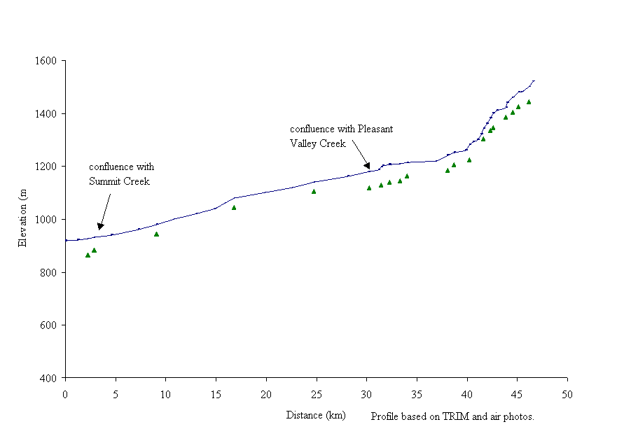
Figure 12. Antler Creek drains an area of 289 km2 as its flows north toward the Bowron River. Fish distribution is based on the Overview assessment. *
Figure 13. Gradient profile of Antler Creek with 21 reaches delineated by triangles. *
Figure 14. Gradient profile of Summit Creek with ten reaches delineated by triangles. *
Figure 15. McKenna Creek flows north into Spectacle Lake, part of Bowron Lake Provincial Park. Fish distribution is based on the Overview assessment. *
Figure 16. Gradient profile of McKenna Creek with five reaches delineated by triangles. *
Photo 1. Indian Point Creek near the stream crossing in reach 9. The water flow is up in the photograph. *
Photo 2. Reach 1 of Ketcham Creek showing some LWD in the creek. The water flows is from left to right. *
Photo 3. The meandering stream channel in reach 2 shows the characteristic channel type of Ketcham Creek. *
Photo 4. The confluence of Antler Creek and Bowron River near the Bowron Lake outlet, which is to the right of the bridge. Antler Creek flows through a man-made channel before it enters the Bowron River. *
Photo 5. Reach 2 of Antler Creek showing channel braiding and extensive mid and side channel bars. A side channel branches off to the right and the water flows is up in the photograph. *
Photo 6. The mainstem of Antler Creek continues to the right with a branch containing equal water flow off to the left. *
Photo 7. A bridge crosses Antler Creek above reach 3 and the water flow is toward the left in the photograph. *
Photo 8. A bridge crosses Antler Creek directly above the confluence of Pleasant Valley and Antler creeks. The water flow is up in the photograph. *
Photo 9. The 13N road crosses Antler Creek near Cunningham Pass. The water flow is down in the photograph. *
Photo 10. Two Sisters Creek mouth in Reaches 4 and 5 of Summit Creek. The water flow is down the photograph. *
Photo 11. An avalanche track-related debris jam in reach 6 of Summit Creek, where the water flow is down the photograph. *
Photo 12. A bridge crosses Grouse Creek near the confluence with Antler Creek. Grouse Creek flows down through the photograph. *
Appendix A General information for the upper Bowron River
Appendix B Overview Assessment – Fish distribution summary forms
Appendix C Overview Assessment – Habitat condition summary forms
At the request of West Fraser Mills Ltd. Quesnel Division, Carmanah Research Ltd. completed an Overview Fish Habitat Assessment Procedure of the upper Bowron River watershed. This document presents the findings of the Overview Fish Habitat Assessment Procedures (FHAP) for the upper Bowron River watershed. As part of the Watershed Restoration Program, the FHAP attempts to identify opportunities and appropriate techniques to restore depressed stocks of fish in streams (Johnston and Slaney, 1996). The Overview is the first stage of the FHAP in that it uses available documents and data to provide a preliminary indication of the factors that limit fish production and fish habitat in the watershed. The Overview FHAP, an office based activity, focuses on streams that are third-order at the 1:50,000 map scale. The results of the Overview will be used to direct subsequent field surveys to impacted areas. Field surveys and ground truthing will eventually lead to the prescription and construction of instream rehabilitation and restoration projects.
The Bowron River flows north into the Fraser River from the Interior Plateau of central British Columbia (Figure 1). It drains an area of 3,420 km2 (Rood and Hamilton, 1995), although only the upper 846 km2 are discussed in this report on the upper Bowron River. The upper Bowron River watershed flows from a portion of the Plateau called the Quesnel Highlands. The average elevation increases towards the southern boundary of the watershed.
The eastern boundary of the watershed abuts Bowron Lake Provincial Park; the Willow River watershed is on the northwestern boundary, Cottonwood River watershed is on the western boundary and the Quesnel River watershed is on the southern boundary. The upper Bowron River watershed study area is located in the Ministry of Environment, Lands and Parks Cariboo Region and the Quesnel Forest District. West Fraser Mills Ltd. defined six tributaries of the upper Bowron River for fish and fish habitat assessment. In order of confluence with the mainstem from the mouth, the sub-basins are Indian Point, Kruger, Antler, Ketchum, McKenna, Summit and Towkuh.
Settlements within the upper Bowron River watershed have populations that, on average, are less than 500 people. Barkerville and Wells are hamlets within the watershed, which can be accessed using Highway 26. The popular recreation destination in the upper Bowron River watershed is Bowron Lake Provincial Park, where a canoe circuit of seven lakes is heavily used. Sub-basin information can be found in Appendix A1.
The Water Survey Gauging Station No.OBKD007, located below Box Canyon, provided the hydrological regime for the Bowron River. Mean annual flow for the Bowron River is 62.5 m3s-1. The 1996 hydrograph indicates that maximum flows take place during May through July, while minimum flows occur December through March (Figure 2). Wintertime 7-day low flow is 15.6 m3s-1 from December to March. Summertime 7-day low flow is 21.70 m3s-1 and occurs in August and September (Rood and Hamilton, 1995). Summer low flow periods occur from the end of July through until the beginning of September during dry summers. Low flows occur throughout the winter months between October and March. Rood and Hamilton (1995) noted that average low flows remain fairly constant. However they explained that, due to episodic rainstorm events, low flows during August might be several times greater than average and approach high flow values recorded for June.
Mining in the upper Bowron River watershed has occurred for the past 100 years and continues today. There are upwards of 100 mineral and placer claims in the watershed boundaries. The majority of historic mining activity has been in the form of the placer gold mining of paleochannels. The abundant glacial and glaciofluvial materials have yielded many million ounces of gold; however some underground mining has also occurred. The Antler Creek watershed contains the most concentrated area of mining related disturbances in the Bowron watershed. Placer mining requires the disturbance of surficial materials and has resulted in obvious and significant impacts on both the material constitution and morphometry of these channels. Claims in other areas have also resulted in surficial disturbance. However, the level of resultant sedimentation and consequent channel changes remains undetermined.
Forestry is the dominant resource use in the upper Bowron River watershed where harvesting has occurred in all sub-basins. The watershed lies within the boundaries of the Quesnel and Prince George Forest Districts. The major operating timber licensees in the entire Bowron River watershed are Northwood Ltd., who operate largely in the lower Bowron River area, and West Fraser Mills Ltd., who operate mainly in the upper Bowron River area. Historical forest harvesting was concentrated in the Indian Point, Towkuh and Ketcham Creek areas. Slopes along the Bowron River mainstem have also been heavily developed. Much of the forest harvesting in the upper Bowron River has been driven by spruce bark beetle control programs and has resulted in significant contiguous cleared areas, mainly in the Towkuh and Ketcham sub-basins. Forest development plans have indicated that future forestry activity would be focused on the Antler, Ketcham and Kruger sub-basins.
The climate in the upper Bowron River watershed is characterised by short hot summers and long cold winters. Annual precipitation ranges from 1,000 to 1,100 mm, with approximately half falling as snow. Mean annual winter temperatures are approximately 0ºC, with January being the coldest month with mean temperatures of -6ºC and extreme minimum temperatures of -50ºC. Summer temperatures are highest in July with mean temperatures of 12ºC and extremes of 37ºC (Rood and Hamilton, 1995).
The upper Bowron River watershed is located in the Fraser Plateau, Cariboo Mountain, and Quesnel Highland physiographic regions. Indian Point and Kruger creeks are located in the Fraser Plateau-Cariboo Mountains physiographic area while Antler, Ketcham and Towkuh creeks are located in the Cariboo Mountain and Quesnel Highland areas. The project area spans the Sub-Boreal Spruce, Interior Cedar-Hemlock, and Englemann Spruce-Subalpine Fir Biogeoclimatic Zones.
The Quesnel Highland area, which includes Antler, Ketcham and Towkuh creeks, was over-ridden by glacial ice during the Pleistocene and is underlain by basalt and cherts of the Mississippian to Permian ages (Levson and Giles, 1993). The area consists of rolling and rounded terrain that has been repeatedly glaciated from the Cariboo Mountains during the Pleistocene era. These glacial events resulted in the deposition of thick glacio-fluvial gravel and glacio-lacustrine silts and clays in meltwater lakes. Rivers and streams presently incise these deposits and many of the flood plains, as seen along Antler Creek, have a very deep layer of glacial tills.
Target fish species in the upper Bowron River watershed are chinook (Oncorhynchus tshawytscha), sockeye salmon (O. kisutch), rainbow (O. mykiss), and bull trout (Salvelinus confluentus). Consultation with the Regional B.C. Fisheries Branch and B.C. Conservation Data Centre indicated that although bull trout are vulnerable there are no other rare, threatened, endangered or regionally significant non-salmonids in the study area.
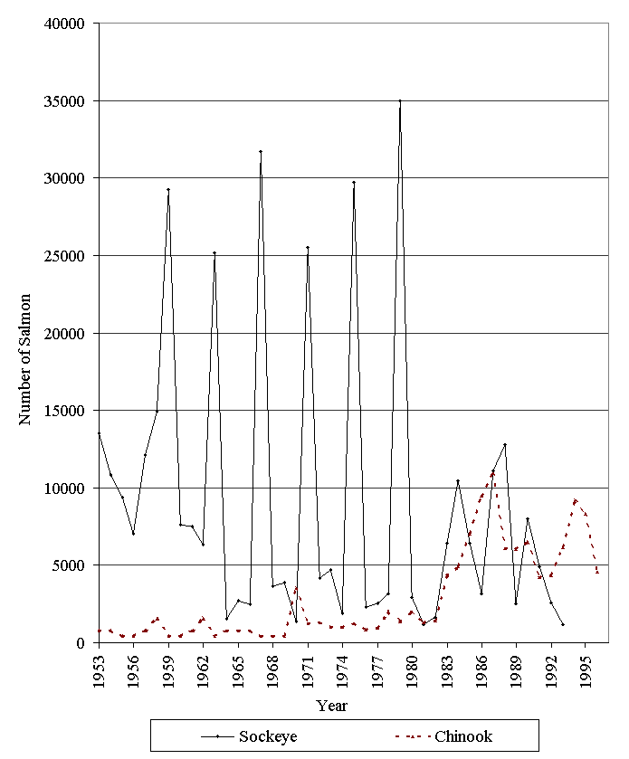
The main commercial anadromous species in this watershed are chinook and sockeye. Escapement surveys on the Bowron River between 1953 to 1993 showed an increasing population trend for sockeye and an increasing trend for chinook (Figure 3). Rowland and McDonald (1996) estimated the rebuilding potential as high for sockeye and medium for chinook. Historical maximum escapement for sockeye was 35,000 in 1979 with an average escapement of 5,927 from 1981 to 1992 and 9,741 from 1969 to 1980. Historical maximum escapement for chinook was 10, 900 in 1987 with an average escapement of 5,387 from 1981 to 1992 and 1,392 from 1969 to 1980 (Rowland and McDonald, 1996).
Forest Renewal British Columbia (FRBC) has funded several projects directed toward improving the breath and quality of information for the Bowron River watershed. Fish inventories on the Antler, Towkuh, and Ketcham creek sub-basins improved assessments of fish habitat by providing interpretations of habitat impacts. Carmanah Research Ltd. (in progress) is completing the fish inventory reports. Other watershed restoration projects include a watershed and site level Riparian Assessment in progress by Carmanah Research Ltd. Brave Engineering Ltd (in progress) is conducting a Sediment Source Survey as part of an Integrated Watershed Restoration Plan on the Bowron River watershed.
The methods used in the Overview FHAP comply with those outlined in pages 14 to 32 of Watershed Technical Circular No.8 (Johnston and Slaney, 1996). The synopsis below presents a summary of the steps in the overview assessment procedures. Base resources include air photographs, Terrain Resource Inventory Management maps (TRIM) and files that were provided by the West Fraser Mills Ltd., Quesnel, and the Ministry of Environment, Lands and Parks (MELP), Cariboo Region, Williams Lake.
The upper Bowron River and the third-order creeks within the watershed were selected for analysis of target fish distribution, forest harvesting activity and fish habitat concerns. Gradient profiles of the sub-basins and selected tributaries were generated from 1:20,000 hard copy TRIM maps. Johnston and Slaney (1996) suggested using 1:50,000 National Topographic Series maps, but the 1:20,000 maps provided a more accurate reflection of the true stream length and profile.
The following individuals were contacted for further information on fish abundance and distribution, forestry, water use, and parks and protected areas.
Stream reaches were established for 12 streams in the study area. Preliminary reach boundaries, or breaks, were determine based on the following equally-weighted criteria:
Waterfalls were also considered to be reach breaks. Within reaches, additional subdivisions identified as sections were based on changes in riparian vegetation or stand characteristics.
The available information on fish distribution and abundance is presented on the sub-basin maps and in Appendix B. The data is discussed in the overview assessment by sub-basin. Fish distribution on the maps is subdivided into fish bearing reaches, potential fish bearing reaches and non-fish bearing reaches. Potential fish bearing reaches were defined based on proximity to fish bearing reaches where no barriers to fish migration was apparent. Non-fish bearing reaches were derived from Forest Practices Code inventory data and, where unavailable, fish distribution was deducted based on the presence of a barrier to fish migration or habitat quality (poor fish production). Where inventory data was unavailable, the reach was labelled undetermined.
Overview assessment of habitat conditions
The 1:15,000 scale air photo coverage for portions of the watershed were flown in 1991, 1995 and 1997. With exception of larger streams, fish habitat conditions were often obscured due to the small scale of the air photos. Within the limitations of the air photographs, habitat conditions are tabulated in the appendices and discussed in the result section. Two half-day reconnaissance helicopters over-flights, conducted on July 24 and August 27, 1997, supplemented the office based overview work. A supplemental flight of Indian Point sub-basin was conducted with Brave Engineering Ltd. as part of their road assessment contract. Still and video photo-documentation were compiled during the over-flight.
Preliminary fish habitat assessment and potential restoration strategies.
We recommended fish inventories where data is currently unavailable. Areas of concern were identified from the air photo analysis during the habitat assessment, and potential fish habitat restoration strategies were suggested. The priority for reaches recommended for assessment was based on the following:
When no impacts were observed during the overview assessment, the reaches are not prioritized. Level 1 assessments are recommended for all reaches that are impacted with initial focus on areas that receive high priority. Since the areas of concern are identified from office-based activities, field verification is necessary to confirm recommendations. Priority assignments may be re-evaluated upon field visitation; if the priority drops, the sites will be evaluated as time permits.
Results: Overview Assessment Sub-basins
Indian Point Creek (100-6570- 632) flows north-west into the Bowron River (Figure 4). The sub-basin drains an area of 249 km2. The creek has a mainstem length of approximately 50 km with 15 reaches delineated in the gradient profile (Figure 5). The reach breaks correspond to the reach boundaries planned for the inventory assessment (Carmanah, in progress). There are two major lakes and several smaller lakes on this sub-basin. Indian Lake is 2 5km upstream of the Indian Point Creek and Bowron River confluence. Indian Point Lake is in the headwaters of the creek. There are four tributaries of Indian Point Creek that were assessed. One unnamed tributary is located 9 km upstream of the confluence of Indian Point Creek and Bowron River, while a second unnamed tributary is located 21 km upstream of the Indian Point Creek and Bowron River confluence. McKitrick Creek (100-6570- 632-487) is located at the outlet of Indian Lake. Kruger Creek (100-6570-632-567) is located 1 km upstream of Indian Lake and is designated as a separate sub-basin.
According to FISS (1994), chinook salmon are found throughout the area (Appendix B1, Figure 4). Spawning grounds are located below Indian Lake on the mainstem of Indian Point Creek. Sockeye salmon are found the lower reaches and suspected to have access throughout the sub-basin. No fish are documented as using the tributaries of Indian Point Creek. Since there appears to be no barriers, fish are suspected to be able to access the lower reaches of the three tributaries. Fish are also expected to use the creek channel between Indian Lake and Indian Point Lake.

Figure 5. Gradient profile of Indian Point Creek with 15 reaches delineated by triangles.
The Indian Point Creek sub-basin has been extensively harvested with numerous access roads constructed on the highly erodible soils (Bowron Watershed Committee, 1997). Harvesting has occurred along the lower reaches of the creek and along tributaries. Leave strips have been left in several places but at several points clearcut areas join up directly with Indian Point Creek. The upper Bowron River Level 1 Interior Watershed Assessment Procedure (IWAP) indicated that the Equivalent Clearcut Area (ECA) for Indian Point Creek sub-basin was 29% for the upper portion and 34% in the lower residual portion (Bowron Watershed Committee, 1997). Based on a highest rating of 1.00, hazard indices for the upper and residual portions of the sub-basin for peak flow was 0.53, surface erosion was 0.63 and 0.74, riparian buffer was 0.78 and 0.63 and landslide was 0.63 and 1.00, respectively (Bowron Watershed Committee, 1997).
Habitat condition and preliminary assessment
Indian Point Creek is characterised as a sinuous marshy channel with extensive riffle and pool habitats. Although logging intensity in the sub-basin is high, the topography and stream channel made it less susceptible to logging impacts (Bowron Watershed Committee, 1997). The Habitat Condition Summary form in Appendix C1 provides a general description of the stream habitat conditions. Observations of the stream channel were limited due to the air photo scale, stream cover and the relative size of Indian Point Creek. Table 1 provides a brief summary of the preliminary assessment of environmental impacts, assigned priority for level 1 assessment and potential restoration opportunities.
The following briefly describes areas of concern on Indian Point Creek on a reach basis based on available data. Sediment wedges and logjams were visible in reaches 1 and 2. Cut blocks lack riparian buffers along the sides of the reach 1 and into reach 2. A Level 1 assessment and a riparian assessment procedure are recommended to assess the potential impacts on fish habitat. A bridged crossing in reaches 1 and 2 should be assessed as a potential sediment source and for impacts on fish habitat. Anecdotal information indicated that the logjams are potential fish obstructions (personal communication, G. Thorburn, 1997). Roads that cross the creek in reaches 4 and 9 should also be assessed for impacts on fish habitat (Photo 1). A cutblock that extends along Indian Lake appears to be greened up although access roads may be impacting the lake. Cutblocks that lack riparian buffers lie along the eastside of the reach 8 and along the both sides of reach 9 before the stream crossing.
Table 1. Preliminary assessment of environmental impacts, priority for Level 1 assessment and restoration opportunities in Indian Point Creek.
|
Sub Basin |
Reach |
Section |
Channel |
Channel |
Habitat |
Upslope |
Potential |
Priority‡ |
Restoration |
|
Name |
Num |
Type* |
Stability† |
Value‡ |
Impact‡ |
Impacts |
Opportunities |
||
|
Indian Point 100-6570-632 |
1 2 |
RPgw |
A |
H |
H |
The riparian area has been clearcut to the creek side. The bridged road that crosses the creek may be a sediment source and impacting fish habitat. Logjams appear to span the creek channel. |
H |
Re-vegetation or bioengineering of upslope areas and riparian areas at the creek crossings, if necessary. Reconstruction or modification of the bridge, if necessary. |
|
|
4 |
RPgw |
S |
H |
H |
The bridged road that crosses the creek may be a sediment source and impacting fish habitat. |
H |
Reconstruction or modification of the bridge, if necessary. |
||
|
5 8 |
L |
S |
H |
L |
The riparian area has been clearcut to the lakeside. |
M |
Re-vegetation or bioengineering of upslope areas and riparian areas at the creek crossings, if necessary. |
||
|
9 |
RPgw |
S |
H |
M |
The road that crosses the creek may be a sediment source. Portions of the riparian area have been harvested. |
H |
Reconstruction or modification of culverts to allow fish passage if found to be a migration barrier. Assess riparian area for impacts on fish habitat. |
||
|
Unnamed tributary 100-6570-632-? |
RPgw |
S |
H |
M |
The riparian area has been clearcut on gullies and smaller tributaries that feed into the tributary. |
H |
Re-vegetation or bioengineering of upslope areas and riparian areas at the creek crossings, if necessary. |
||
|
Unnamed tributary 100-6570-632-? |
1 2 |
RPgw |
S |
H |
M |
The riparian area has been clearcut on gullies and smaller tributaries that feed into the tributary. |
H |
Re-vegetation or bioengineering of upslope areas and riparian areas at the creek crossings, if necessary. |
|
|
McKitrick Creek 100-6570-632-487 |
1 |
RPgw |
S |
H |
M |
The bridged road that crosses the creek may be a sediment source and migration barrier. |
H |
Reconstruction or modification of the bridge, if necessary. |
|
|
2 |
RPgw |
S |
H |
M |
The riparian area has been clearcut on gullies and smaller tributaries. |
H |
Re-vegetation or bioengineering of upslope areas and riparian areas at the creek crossings, if necessary. |
||
Both unnamed tributaries have been logged on both sides for their entire length. Although an adequate riparian buffer appears along the stream, all gullies and smaller tributaries have been clearcut to the stream edge. This may promote debris and sediment transport into the unnamed tributaries. The tributaries should be assessed for fish presence or absence before habitat restoration work is proposed. There appears to be no barriers to fish access into the tributaries.
The entire length of McKitrick Creek has been logged with more recent logging in the lower portions. The cut blocks appear to have adequate riparian buffers. McKitrick Creek should be assessed for fish presence or absence prior to conducting habitat restoration work. There appear to be no barriers to fish access. A bridge crosses McKitrick Creek in reach 1 and should be assessed as a potential sediment source.
Restoration opportunities include removal of, or passage creation around, logjams from reaches 1 and 2 of Indian Point Creek and re-vegetation of riparian areas throughout the sub-basin, as necessary.
Kruger Creek (100-6570-632-567) flows northwest into Indian Point Creek and drains an area of 55 km2 (Figure 4). The creek has a mainstem length of approximately 24 km with eight reaches delineated in the gradient profile (Figure 6). Littlefield Creek, the major tributary of Kruger Creek, is located approximately 9km upstream of the confluence of Kruger and Indian Point creeks. There are two major lakes along the mainstem of Kruger Creek. One lake is 10 km upstream of the confluence of Kruger and Indian Point creeks while Kruger Lake is approximately 13 km upstream of the confluence of Kruger and Indian Point creeks.
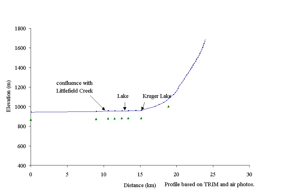
Figure 6. Gradient profile of Kruger Creek with eight reaches delineated by triangles.
According to FISS (1994), chinook salmon spawn in reach 1 and 2 (Appendix B2, Figure 4). Chinook are suspected up to reach 6 where the gradient may limit upstream migration. Chinook are also expected to access the first four reaches of Littlefield Creek.
The Kruger Creek sub-basin has been harvested along the lower 4 reaches of the creek and along tributaries. Riparian areas have been left in several places but at several points clearcut areas join up directly with Kruger Creek. The upper Bowron River IWAP indicated that the Equivalent Clearcut Area for Kruger Creek sub-basin was low at 20% (Bowron Watershed Committee, 1997). Based on a highest rating of 1.00, hazard indices were for peak flow was 0.34, surface erosion was 0.39, riparian buffer was 0.47 and landslide was 0.26 (Bowron Watershed Committee, 1997). Littlefield Creek has seen some harvesting with an ECA of 13% (Bowron Watershed Committee, 1997). Impacts in this creek are result of the extensive road network created largely by mining development. A large amount of the roads occur on highly erodible soils. This has resulted in a surface erosion hazard of 1.00 with a high possibility of fines being delivered to the creek from poor road construction (Bowron Watershed Committee, 1997). Littlefield Creek is a potential fish-bearing stream.
Habitat condition and preliminary assessment
Kruger Creek is characterised as a sinuous marshy channel with extensive riffle and pool habitats. The Habitat Condition Summary form in Appendix C2 provides a general description of the stream habitat conditions based on available data. Observations of the stream channel were limited due to the air photo scale, stream cover and the relative size of Kruger Creek. Habitat concerns include inadequate of riparian areas, isolated wetlands and poorly designed culverts. Table 2 provides a brief summary of the preliminary assessment of environmental impacts, assigned priority for level 1 assessment and potential restoration opportunities.
The following briefly describes the areas of concern on Kruger Creek on a reach basis based on available data. The lower reaches of Kruger Creek are characterised by a sinuous riffle-pool habitat. The area around the tributaries of reaches 1 and 2 have been logged but no impacts could be detected on the main channel. Since chinook use the main channel for spawning, and likely rearing, reaches 1 and 2 should be assessed for logging impacts on fish habitat. Harvesting along the banks of tributaries that feed into reaches 1 and 2 may be causing impacts on the fish habitat in the main channel of Kruger Creek. A small lake forms reach 3. Logging occurred in reach 4 during 1987-88 where an access road crosses the creek. The stream crossing should be assessed as a potential sediment source and for impacts on fish habitat. The riparian area appears to be intact. Reaches 6 and 7 contain a meandering creek channel that flows through low-lying wetlands. No logging impacts could be determined on these two reaches. In reach 8 overhanging vegetation obscured the channel.
Littlefield Creek flows into Kruger Creek between reaches 2 and 3 and is characterised by a meandering riffle and pool channel in reaches 1 through 4. As the creek flows from alpine area of the Cariboo Mountains, reach 5 is contained in a more confined channel. Although harvesting has occurred along reaches 1 through 3 no impacts on fish habitat were observed. Harvesting along the banks of tributaries that feed into reaches 1, 2 and 3 may be causing impacts on the fish habitat in the main channel of Littlefield Creek. Forestry access roads continue into reach 3 of Littlefield Creek. The first three reaches of Littlefield Creek should also be included in as part of a Level 1 Assessment of Kruger Creek to confirm fish presence and assess the amount of sediment impacts from roads on the potential fish habitat.
Table 2. Preliminary assessment of environmental impacts, priority for Level 1 assessment and restoration opportunities in Kruger Creek.
|
Sub Basin |
Reach |
Section |
Channel |
Channel |
Habitat |
Upslope |
Potential |
Priority |
Restoration |
||
|
Name |
Num |
Type* |
Stability† |
Value‡ |
Impact |
Impacts |
Opportunities |
||||
|
Kruger Creek 100-6570-632-567 |
1 |
RPgw |
S |
H |
L |
The riparian area has been clearcut on gullies and smaller tributaries. |
H |
Re-vegetation or bioengineering of upslope areas and riparian area, if necessary. |
|||
|
2 |
RPgw |
S |
H |
L |
The riparian area has been clearcut on gullies and smaller tributaries. |
H |
Re-vegetation or bioengineering of upslope areas and riparian area, if necessary. |
||||
|
4 |
RPgw |
S |
M |
L |
The bridged road that crosses the creek may be a sediment source or impacting fish habitat. |
M |
Reconstruction or modification of the crossing, if necessary. Bioengineering of the upslope area, if found to be a sediment source. |
||||
|
Littlefield Creek 100-6570-632-567-345 |
1 |
RPgw |
S |
H |
M |
The riparian area has been clearcut on gullies and smaller tributaries. The stream crossing may be a potential barrier or sediment source. |
H |
Re-vegetation or bioengineering of upslope areas and riparian area, if necessary. Assess the stream crossing for potential habitat impacts. |
|||
|
2 |
CPgw |
S |
H |
M |
The riparian area has been clearcut on gullies and smaller tributaries. |
H |
Re-vegetation or bioengineering of upslope areas and riparian area, if necessary. |
||||
|
3 |
RPgw |
S |
H |
M |
The riparian area has been clearcut on gullies and smaller tributaries. The stream crossing may be a potential barrier or sediment source. |
H |
Re-vegetation or bioengineering of upslope areas and riparian area, if necessary. Assess the stream crossing for potential habitat impacts. |
||||
Recommendations
Restoration opportunities on Kruger Creek include improving fish access into upper reaches of the mainstem and modification of stream crossings if found to be migration barriers.
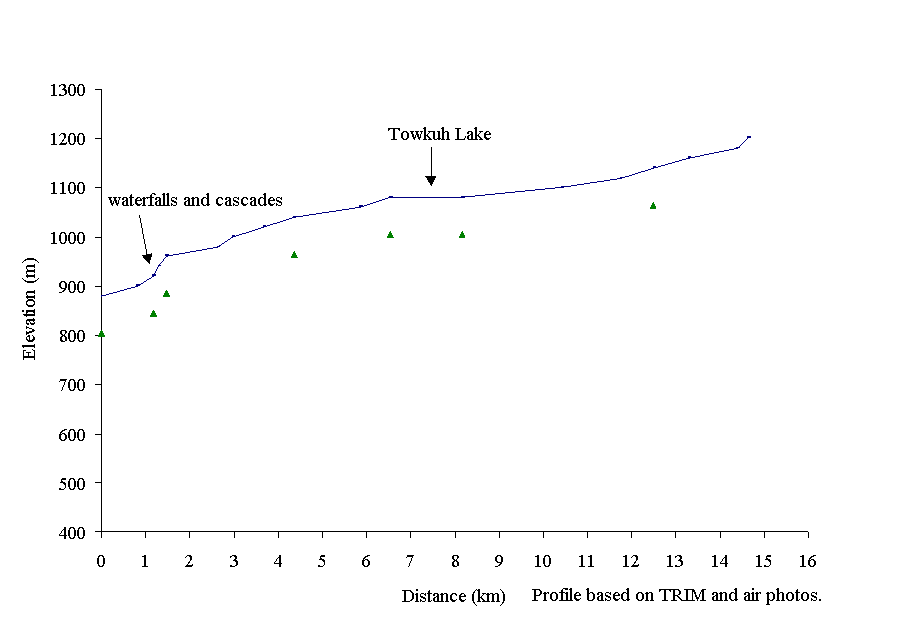 Towkuh Creek
(100-6570-715) flows east into the Bowron River and drains an area of 37.8 km2
(Figure 7). The elevation ranges from 900m at the Bowron River confluence to
1500m in its headwaters. The mainstem has a length of approximately 17km with
seven reaches delineated in the gradient profile (Figure 8). The profile is
based on reach breaks provided by the reconnaissance fish inventory of Ketcham
and Towkuh creeks (Carmanah, 1997b). Towkuh Creek lies within a V shaped valley,
on the edge of the Palmer Range, in the Quesnel Highlands of the Interior Plateau.
Towkuh Creek drains Towkuh Lake. There is a 12m cascading waterfall with over
30% gradient located 1500m from its confluence with Bowron River.
Towkuh Creek
(100-6570-715) flows east into the Bowron River and drains an area of 37.8 km2
(Figure 7). The elevation ranges from 900m at the Bowron River confluence to
1500m in its headwaters. The mainstem has a length of approximately 17km with
seven reaches delineated in the gradient profile (Figure 8). The profile is
based on reach breaks provided by the reconnaissance fish inventory of Ketcham
and Towkuh creeks (Carmanah, 1997b). Towkuh Creek lies within a V shaped valley,
on the edge of the Palmer Range, in the Quesnel Highlands of the Interior Plateau.
Towkuh Creek drains Towkuh Lake. There is a 12m cascading waterfall with over
30% gradient located 1500m from its confluence with Bowron River.
Figure 8. Gradient profile of Towkuh Creek with seven reaches delineated by triangles.
Towkuh Creek fish populations are confined to the lower 1500m of Towkuh Creek below the 12m cascading waterfall. Chinook, rainbow, and bull trout are present in Towkuh Creek (FISS, 1994; Figure 6; Appendix C3). Sculpins (Cottus sp.) and mountain whitefish (Prosopium williamsoni) are also present. According to FISS (1994), chinook spawning occurs along the mainstem of Bowron River opposite Towkuh Creek. It is suspected that chinook use Towkuh Creek as a spawning site but this should be confirmed. Chinook use the area below the falls as a rearing area. Rainbow trout and bull trout also inhabit Towkuh Creek. There are no records of fish above the 12 m waterfall and in Towkuh Lake (Carmanah, 1996b).
The Towkuh Creek sub-basin has been extensively harvested due to beetle salvage operations in the mid-1980’s. Forest harvesting has occurred along Towkuh Creek resulting in the removal of the riparian area in several reaches. Towkuh Creek has an equivalent clearcut area of 52% that is concentrated from the creek mouth to Towkuh Lake. Based on a highest rating of 1.00, the IWAP hazard indicators rate the peak flow, surface erosion and riparian buffer indexes as 1.0 (Bowron Watershed Committee, 1997). Highly erodible Pleistocene glacial tills combined with the substantial number of roads have created a high concern for sediment input into the system. This sediment has the potential to accumulate in downstream channels and smother fish habitat. The extensive harvesting has impacted the stream flow and discharge patterns due to a change in peak flows, hydrologic recovery and storage. High peak flows indicate a high risk of stream bank erosion and flooding (Beaudry, 1997) and can be expected to transport debris and sediment to lower salmon bearing reaches of the system.
Harvesting of the riparian vegetation has occurred along Towkuh Creek. Reach 1 was logged on the northern side of the channel down to the flood plain in 1979. Reaches 3 through 5 are characterised by a mixed conifer, deciduous and shrub riparian area that fluctuates from a relatively good riparian buffer of approximately 30 m in width down to no buffer at all. All gullies that are connected to Towkuh Creek have been logged.
The main channel of Towkuh Creek contains sparse vegetation cover. Reach 1 shows signs of bank erosion and channel aggradation. Channel characteristics and disturbance indicators are not visible for the upper reaches due to air photo scale and stream cover. However, the high ECA combined with a limited riparian buffer indicates that sediment and debris inputs into the Towkuh Creek channel are a high possibility. Although fish are not present in the upper reaches of the sub-basin, sediment and debris have the potential of impacting the fish bearing reaches of the creek.
Habitat condition and preliminary assessment
The Habitat Condition Summary from in Appendix B3 provides a general description of the stream habitat conditions. The stream channel observations were limited due to air photo scale, stream cover and the relatively small size of Towkuh Creek. Table 3 provides a brief summary of the preliminary assessment of environmental impacts, assigned priority for Level 1 assessment and potential restoration opportunities.
Table 3. Preliminary assessment of environmental impacts, priority for Level 1 assessment and restoration opportunities in Towkuh Creek.
|
Sub Basin |
Reach |
Section |
Channel |
Channel |
Habitat |
Upslope |
Potential |
Priority |
Restoration |
||
|
Name |
Num |
Type* |
Stability† |
Value‡ |
Impact |
Impacts |
Opportunities |
||||
|
Towkuh Creek 100-6570-715 |
1 |
RPcw |
D |
H |
M |
Historic logging activity and upstream sediment and debris input |
H |
Re-vegetation or bioengineering of upslope areas and riparian area, if necessary. |
|||
|
2 |
SPr |
D |
L |
L |
Adjacent historical harvesting and exposed sediment sources |
L |
Bank stabilisation and riparian rehab. |
||||
|
3 4 5 |
RPcw |
S |
L |
M |
Adjacent historical harvesting and exposed sediment sources |
L |
Bank stabilisation and riparian rehab. |
||||
|
6 7 |
RPcw |
S |
L |
M |
Logging into portions of the riparian area. |
L |
Re-vegetation or bioengineering of upslope areas and riparian area, if necessary. |
||||
The following briefly describes areas of concern on Towkuh Creek on a reach basis based on available data. Channel conditions were inconclusive and are available for the lower half of reach 1. Mid-channel and point bar sediment accumulations were noted along with a significant landslide approximately 600 m up from the confluence with Bowron River on the north bank (Site 1, Carmanah, 1997b). Riparian buffers along the northern logged side of reach 1 appear to consist of pole sapling stage regeneration and shrub. Extensive upslope disturbances and cleared gullies were noted along both sides of reaches 3 through 5. Reaches 6 and 7 of Towkuh Creek are not suspected to contain fish due to the waterfall in reach 1 (Carmanah, 1997b). The channel in reaches 6 and 7 meander through a low-lying area with riffle and pool habitats. Part of reach 7 contains wetlands while other areas have inadequate riparian zones.
Restoration opportunities on Towkuh Creek include increasing rearing and over-wintering habitats in reach 1. Opportunities outside of the scope of this WRP may be the pioneer seeding of resident fish populations into upper non-fish bearing reaches of the watershed. However, this is expected to have future forest development and planning impacts on West Fraser Mills Ltd. and present aquatic invertebrates communities in the watershed and should be undertaken only with further assessments and consultation with MELP and MoF specialists.
 West Creek flows
north into the Bowron River and has a mainstem length of approximately 10 km
(Figure 9). Six reaches were delineated in the gradient profile (Figure 10).
Ketcham Creek, a main tributary of West Creek, flows east into West Creek three
km upstream from the Bowron River and West Creek confluence. The main channel
of Ketcham Creek has a length of 30 km with 10 reaches delineated in the gradient
profile (Figure 11). The profile is based on reach breaks provided by the reconnaissance
fish inventory of Ketcham and Towkuh creeks (Carmanah, 1997b). The elevation
increases from 900m at the Bowron River to 3900m in its headwaters. Both sub-basins
combine to drain an area of 126 km2.
West Creek flows
north into the Bowron River and has a mainstem length of approximately 10 km
(Figure 9). Six reaches were delineated in the gradient profile (Figure 10).
Ketcham Creek, a main tributary of West Creek, flows east into West Creek three
km upstream from the Bowron River and West Creek confluence. The main channel
of Ketcham Creek has a length of 30 km with 10 reaches delineated in the gradient
profile (Figure 11). The profile is based on reach breaks provided by the reconnaissance
fish inventory of Ketcham and Towkuh creeks (Carmanah, 1997b). The elevation
increases from 900m at the Bowron River to 3900m in its headwaters. Both sub-basins
combine to drain an area of 126 km2.
Figure 10. Gradient profile of West Creek with six reaches delineated by triangles.
Chinook salmon, rainbow and bull trout are found in Ketcham Creek (Appendix B4; Figure 10; Carmanah, 1997b). Non-game species include burbot (Lota lota), lake chub (Couesius plumbeus), long-nosed sucker (Catostomus catostomus), mountain whitefish (Prosopium williamsoni) and sculpin (Cottus sp.) (Carmanah, 1997b).
Chinook spawning takes place in reach 1 of Ketcham Creek that flows into reach 1 of West Creek (Carmanah, 1997b). As a result chinook spawning and rearing is expected to be occurring throughout certain areas of reach 1 of West Creek and up into reach 1 of Ketcham Creek. The upper limit of chinook spawning in Ketcham Creek is not known. Chinook spawning habitat is suspected to continue into the upper end of reach 1 where a natural change in overall channel morphology would likely limit chinook spawning habitats.
Rainbow trout are noted throughout both Ketcham and West Creeks, existing in the upper reaches of each. Rainbow trout have also been confirmed in two tributaries of Ketcham Creek: 100-6570-750-300-748 and 100-6570-750-300-195 (Carmanah, 1997b). Rainbow trout are expected to be present in most other tributaries that are accessible from the mainstem, such as tributaries 100-6570-750-300-975 and 100-6570-750-300-687 (Carmanah, 1997b).
Bull trout are present in Ketcham Creek and in tributaries KELP 13 and 100-6570-750-300-608 on the south bank of the creek. They are located along reach 5 of Ketcham Creek. Bull trout are likely present in Ketcham Creek mainstem and other tributaries within similar reaches. There are no confirmed sightings of bull trout in West Creek.
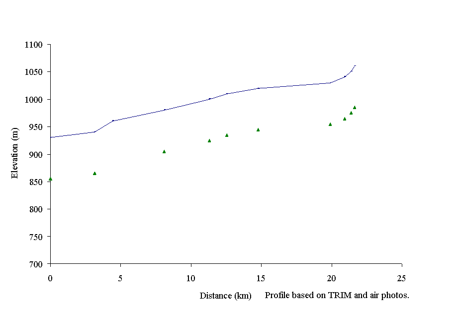
Figure 11. Gradient profile of Ketcham Creek with ten reaches delineated by triangles.
West and Ketcham creeks had an ECA of 42% (Bowron Watershed Committee, 1997). Based on a highest rating of 1.00, the IWAP hazard indicators are 0.91 for peak flow, 0.99 for surface erosion, 1.00 for riparian buffer and 0.45 for landslides (Bowron Watershed Committee, 1997). The high hazard ratings are a concern due to changes in stream discharge patterns, peak flow duration and timing. A mitigating factor of these concerns is the buffering capacity of the meandering channel that is characteristic of Ketcham Creek. Ketcham Creek contains beaver dams that provide limited storage capacity and buffer against high peak flows that result from increased snow accumulations on logged slopes (Bowron Watershed Committee, 1997). Signs of channel disturbance associated with increased peak flows, such as bank scour and outward channel migration, are not evident from air photo analysis. Channel impacts from increased peak flows are likely caused by transport of fine sediment from the more resilient meandering reaches to chinook spawning areas in Ketcham and West creeks.
Harvesting in West Creek took place in the reaches 5 and 6 in 1959 and 1961. Debris and sediment input into reaches 5 and 6 may have been significant due to the high degree of site disturbance that is still evident in the form of entrenched chevron regeneration patterns (Carmanah, 1997b). Streamside logging along 1.3 km of the upper portion of reach 2, reach 3 and the lower portion of reach 4 in the late 1960's and early 1970's is largely in the pole sapling stage with some areas classified as not satisfactory restocked (NSR). Reach 1 of West Creek is undisturbed by forest development activity however, small abandoned placer mining sites are scattered along this reach.
Habitat condition and preliminary assessment
The Habitat Condition Summary Form in Appendix B4 provides a general description of the stream habitat conditions. Table 4 provides a list of West and Ketcham creeks sub-basin priority areas with habitat concerns on a reach basis and provides the priority rating for Level 1 field assessment. The following briefly describes the areas of concern on West Creek on a reach basis.
Due to dense overhanging vegetation, only the lower portion of reach 1 of West Creek can be described. Habitat observations were taken from 1996 Fish Inventories of the creek (Carmanah, 1997b). Reach 1 of West Creek is a continuation of Ketcham Creek and is likely mis-coded. The reach flows from confluence of Ketcham and West Creek through mature conifer riparian habitat before it enters the Bowron River mainstem. Fish habitat impacts are unknown. No channel impacts were noted along this reach, however, this reach is immediately below reach 1 of Ketcham Creek that has been harvested to the stream bank along much of its length.
Table 4. Preliminary assessment of environmental impacts, priority for Level 1 assessment and restoration opportunities in West and Ketcham sub-basin.
|
Sub Basin |
Reach |
Section |
Channel |
Channel |
Habitat |
Upslope |
Potential |
Priority |
Restoration |
|||
|
Name |
Num |
Type* |
Stability† |
Value‡ |
Impact |
Impacts |
Opportunities |
|||||
|
West Creek 100-6570-750 |
1 |
RP |
S |
H |
L |
Upstream streamside harvesting |
H |
Fish habitat rehab. |
||||
|
2 3 4 |
RP |
S |
H |
L |
Historic streamside harvesting, riparian buffer impairment |
H |
Fish habitat and riparian buffer rehab. |
|||||
|
Ketcham Creek 100-6570-750-300 |
1 2 |
RP |
S |
H |
L |
Streamside harvesting and loss of riparian buffer |
H |
Fish habitat and riparian buffer rehab. |
||||
|
KELP 13 |
1 2 |
S |
M |
L |
Harvesting across stream and culvert barrier to migration |
M |
Restore bull trout access and habitat, riparian rehab. |
|||||
|
Unnamed tributary 100-6570-750-300-195 |
S |
M |
L |
Through stream harvesting and road erosion |
M |
Bank stabilisation and riparian rehab |
||||||
|
Unnamed tributary 100-6570-750-300-975 |
S |
M |
L |
Through stream harvesting and road erosion |
M |
Bank stabilisation and riparian rehab |
||||||
Reaches 2 and 3 and the lower part of reach 4 of West Creek flow through a 20 year old clear-cut area that is in an advanced stage of regeneration. Riparian buffers are willow and alder. The dominant channel type is riffle-pool with large amounts of old LWD in the channel that were likely recruited during the harvesting in the early 1970’s. Habitat impacts in this reach are largely associated with the advanced stage of decay of LWD in the channel and the lack of large organic debris in the riparian zone. Pool-riffle-run ratio was 30/35/35 indicating good pool habitat ratios (Carmanah, 1997b). Several sediment dams were noted in reach 3.
The upper portion of reach 4 is less confined and contains excellent habitat with large root wads that have created good gravel bars and pools for trout spawning habitat. LWD provides 50% of the cover in this reach (Carmanah, 1997b). A small beaver dam is located at the top of reach 4.
Reaches 5 and 6 of West Creek do not contain target fish (Carmanah, 1997b). Water flows and habitat availability are rated as low in these reaches.
Restoration opportunities on West creek are unknown.
Ketcham Creek consists of ten reaches. Nine of these reaches are characterised by very low gradient meandering stream channels that wind through an extensive floodplain. Reach 1 is a higher gradient reach that consists of pool-riffle habitats that chinook use for spawning. The tortuous meandering channel typical of the majority of Ketcham Creek begins in reach 2 and extends to the upper reaches of the watershed.
Streamside harvesting occurred in 1976 along the upper 1700 m of reach 1 of Ketcham Creek. The riparian area is composed of shrub and pole-sapling seral stages. Chinook spawning occurs in this portion of the reach. Pool habitats were noted as being good and LWD as abundant (Carmanah, 1997b; Photo 2). Channel disturbance was limited to some areas showing un-vegetated bars immediately below the mouth of the aggraded tributary 100-6570-750-300-195. Fine sediment accumulations were present in this reach (Carmanah, 1997b). The bridge crossing above this reach was noted to be constricting the channel and chinook were noted to be spawning below the bridge (Site 2, Carmanah, 1997b).
A heavily aggraded unnamed tributary (100-6570-750-300-195) impacts the upper end of reach 1. This tributary contains resident rainbow trout (Carmanah, 1997b). Harvesting from the 1970’s, the 2400 road and an inactive spur road have impacted the tributary. The catchment area for this tributary is large and there is a steep gradient. Field surveys of this tributary have noted it to be a high energy system. Air photo analysis shows significant aggradation of sediment in this tributary and in the sections of reach 1 of Ketcham Creek immediately below the confluence.
Above reach 1 the channel begins its meandering route. Riparian zones consist of marsh bordered by mature conifer (Photo 3). Although portions of upslope areas have been harvested the resilient nature of the meandering channel appears to have mitigated any possible peak flow related channel disturbance. Buffers of mature timber have been left since the harvesting in the 1980’s which has permitted some regeneration. There are no signs of outward bank migration, bank scour or cutting off of meander bends that would be expected from high peak flow impacts. Beaver activity has created a number of natural obstructions in these reaches. These reaches were considered to have a low level of fish habitat impacts as the floodplain dissipates the energy of higher flows.
Logging activities that cross the stream channel impact tributaries to Ketcham Creek. In particular, tributaries100-6570-750-300-195, 100-6570-750-300-975, 100-6570-750-300-608 and KELP 13 (KEtcham Locator Point) all show signs of debris accumulation and aggradation. Riparian buffers in these tributaries largely consist of shrub and deciduous in-growth. These tributaries are known and suspected fish bearing streams.
Carmanah (1997b) noted that tributary 100-6570-750-300-975 is ephemeral. The entire drainage area of this tributary has been harvested and it is suspected that lower portions of the creek support rainbow trout during high flows. The increase peak flows and the decreased hydrologic storage capacity associated with the large amount of cleared area may be having a significant impact on flow patterns in this creek, particularly a de-watering of the stream channel in summer months. Fish habitat and access to lower fish bearing areas are noted in this creek.
Tributary 100-6570-750-300-975 marks the upper boundary of reach 1. Signs of channel aggradation and road erosion are evident in reach 1 of this creek. The drainage area of this creek has a high degree of harvesting activity and the high peak flows associated with this may be transporting significant sediment to chinook bearing reach 1 of the Ketcham mainstem. Rainbow trout have been noted in this reach. Riparian buffers consist of pole-sapling deciduous species. The end of a spur road fords the creek (Site 3, Carmanah, 1997b), which appears to be actively eroding road fill.
Tributaries 100-6570-750-300-608 and KELP 13 contain bull trout and both traverse through large clear-cuts before they cross the 2400 road. The 2400 road and the culverts on it were noted to be fish obstructions to the lower portions of these tributaries that contain bull trout. Habitat in clear-cut reaches above the road, in particular KELP 13, has been noted during fish inventories as being suitable fish habitat. All road crossings and the portion of KELP 13 above the 2400 road should be assessed for fish passage and habitat restoration. Riparian assessments should be undertaken on KELP 13 above the road crossing as that area may be fish bearing and should have an adequate riparian area.
Restoration opportunities on Ketcham Creek and tributaries include restoring bull trout habitat and increasing access into the upper portion of KELP 13, bank stabilisation, and unknown opportunities in reach 1 of mainstem.
Antler Creek lies within a steep V shaped valley, on the edge of the Palmer Range, in the Quesnel Highlands of the Interior Plateau, and drains an area of 289 km2 (Figure 12). Antler Creek is a fourth order stream located approximately 7 km east of the town of Barkerville, BC. The Antler Creek sub-basin is the fourth largest sub-basin in the upper Bowron River watershed behind the Haggen, Bowron residual and Indian Point sub-basins. The sub-basin drains north, parallel to the Bowron Lake Provincial Park, from its headwaters at Race Track Creek to its mouth, approximately 47 km downstream, at the Bowron River. Twenty-one reaches were delineated on the gradient profile (Figure 13). Reaches 1 and 2 of the Antler mainstem flow directly through the north-western end of Bowron Lake Provincial Park and the associated private lands of the Bowron Lodge. The elevation ranges from 900m at the Bowron River confluence to 1220 m in its headwaters at Race Track Creek. Surficial material in the watershed consists of Palaeozoic glacial tills. Antler Creek has seven main tributaries and many small first and second order tributaries, which are all, confined within steep sided valleys (Figure 12).
Chinook salmon, rainbow and bull trout are present in Antler Creek (FISS, 1994; Carmanah, 1997a; Appendix B). Non-game species include burbot, lake chub (Couesius plumbeus), long-nosed sucker, and red-side shiner (Richardsonius balteatus) (FISS, 1994).
According to FISS (1994), chinook spawn up to Cunningham Pass in reach 11 (Figure 14). Chinook spawning is also known to occur in reach 1of Pleasant Valley Creek (100-6570-769-635) and is expected to occur in other areas throughout the mainstem. Habitat for rearing of chinook salmon has been confirmed in reach 1 of Grouse Creek and reach 3 of the mainstem (Carmanah, 1997a). It is expected that chinook rearing occur along the entire length of Antler Creek and in accessible reaches of all tributaries below known spawning areas and in any available side channel or pool type habitats.
 Rainbow trout
reside throughout the mainstem and are confirmed up to reach 14 (Carmanah, 1997a).
Rainbow trout are also present in many of the second and third-order tributaries.
Bull trout are confirmed in the lower mainstem of Antler Creek up to reach 3,
Atan Lake, in the upper portion of the Antler Creek mainstem and tributaries
to reaches 13 and 14, in reach 1 of Pleasant Valley Creek (100-6570-769-635),
reach 1 of Grouse Creek (100-6570-769-635-051), and Monkton Creek (100-6570-769-579)
(Carmanah, 1997a).
Rainbow trout
reside throughout the mainstem and are confirmed up to reach 14 (Carmanah, 1997a).
Rainbow trout are also present in many of the second and third-order tributaries.
Bull trout are confirmed in the lower mainstem of Antler Creek up to reach 3,
Atan Lake, in the upper portion of the Antler Creek mainstem and tributaries
to reaches 13 and 14, in reach 1 of Pleasant Valley Creek (100-6570-769-635),
reach 1 of Grouse Creek (100-6570-769-635-051), and Monkton Creek (100-6570-769-579)
(Carmanah, 1997a).
Figure 13. Gradient profile of Antler Creek with 21 reaches delineated by triangles.
Antler Creek was subjected to extensive mining activity in the mid-1800 associated with the Cariboo Gold Rush. There are several active placer mining operations in the sub-basin. Placer mining along tributaries and the Antler Creek main stem combined with the associated site and forest clearing have had the dominant impact on the sub-basin (Bowron Watershed Committee, 1997). Sediment input into Antler Creek is considered to be significant. The extent that present day observed channel conditions could be attributed to these historic activities is uncertain. Carmanah (in progress, A) noted several areas where channel impacts were a result of placer mining activity. These were reach 18 of the Antler Creek mainstem and two tributaries to Antler Creek; Grouse Creek (100-6570-769-635-051), which contains chinook, rainbow and bull trout, and Nugget Gulch (100-6570-769-867).
The upper Bowron River Level 1 IWAP indicated that forestry associated impacts on the watershed are low (Bowron Watershed Committee, 1997). The overall Equivalent Clearcut Area (ECA) for Antler Creek was 8%. Bowron Watershed Committee (1997) described the level of hydraulic concern related to forest harvesting and the priority for implementing a road survey as low while the priority for implementing a channel assessment was medium. Hazard indices for Antler Creek, based on a highest rating of 1.00, for peak flow was 0.29 and riparian buffer was 0.37. The surface erosion and landslide indices were rated as high due to the highly erodible nature of the underlying glacial tills in the watershed (Bowron Watershed Committee, 1997).
Forest harvesting has largely been centred in the lower reaches of the Antler Creek watershed and lower Summit Creek. Streamside harvesting has taken place along the Antler Creek floodplain terrace in reaches 1 through 3 between 1956-70. This included the mouth of Summit Creek. Summit Creek has also seen some limited harvesting along reach 5 during 1957.
Habitat condition and preliminary assessment
The Habitat Condition Summary form in Appendix C5 provides a brief description of stream habitat conditions. Descriptions of Antler Creek, its third-order tributaries and any other tributaries that are potentially impacting the stream channel are presented in the following section. Table 5 provides a summary of preliminary habitat assessment, restoration opportunities and assigned priorities for Level 1 assessment.
Table 5. Preliminary assessment of environmental impacts, priority for Level 1 assessment and restoration opportunities on Antler Creek.
|
Sub Basin |
Reach |
Section |
Channel |
Channel |
Habitat |
Upslope |
Potential |
Priority |
Restoration |
||||||||
|
Name |
Num |
Type* |
Stability† |
Value‡ |
Impact |
Impacts |
Opportunities |
||||||||||
|
Antler Creek 100-6570-769 |
1 2 3 |
RPgw |
A |
H |
H |
Channel aggradation, isolated rearing habitats, pool infilling |
H |
Access to isolated side and back channel habitats |
|||||||||
|
6 |
RPgw |
A |
H |
H |
Channel aggradation from Grouse Creek placer mining activity |
H |
Pool habitat rehabilitation. |
||||||||||
|
7 8 9 10 11 12 13 14 |
RPgw |
A |
H |
H |
Adjacent road, historic mining development causing loss of riparian buffer |
H |
Habitat rehabilitation |
||||||||||
|
18 |
Channel relocation associated with historical mining development |
M |
Habitat rehabilitation and channel restoration |
||||||||||||||
|
Summit Creek 100-6570-769-062 |
1 |
RPgw |
A |
H |
H |
Aggradation from natural sources and historic placer mining activity |
H |
Rearing habitat rehabilitation |
|||||||||
|
7-8 |
CPcw |
A |
H |
H |
Adjacent mining development, bank destabilisation |
M |
Bank stabilisation and habitat rehabilitation |
||||||||||
|
Pleasant Valley Creek 100-6570-769-635 |
1 |
RP |
A |
H |
H |
Placer mining and associated channel aggradation |
H |
Bank stabilisation and pool habitat rehabilitation |
|||||||||
|
Grouse Creek 100-6570-769-635-051 |
1 |
RP |
A |
H |
H |
Placer mining and associated channel aggradation |
H |
Bank stabilisation and pool habitat rehabilitation |
|||||||||
|
Nugget Gulch 100-6570-769-867 |
1-2 |
RP |
A |
H |
H |
Historic mining development |
H |
Habitat rehabilitation |
|||||||||
The following briefly describes the areas of concern on Antler Creek on a reach basis based on available data. The lower reaches of Antler Creek mainstem indicate significant channel aggradation and channel relocation as several side channel areas are isolated from the main channel. The presence of mid-channel and point bars in the Bowron River, near the confluence with Antler Creek, suggests that Antler Creek is a main sediment source to the Bowron River. Additional channel braiding, widening and loss of sinuosity in the lower reaches of Antler and Summit creeks indicate that Antler Creek actively transports large amounts of sediment. Natural landslides along canyon reaches 4 and 5 and placer mining activity in tributaries, in particular Grouse Creek, are potential sources of sediment.
The channel of Antler Creek splits into two arms; the right arm or mainstem drains into the Bowron River just below Bowron Lake and the left arm drains to Bowron River a few km downstream. A thorough channel assessment would be required to confirm any changes in channel form as this report provides only a sketch of present channel conditions and morphology. A detailed description of the effects of sedimentation on Antler Creek should be undertaken.
Air photographs were only available up to reach 15, excluding reach 12 and part of reach 11, for the Antler Creek mainstem and associated tributaries. Aerial video was taken and upper reaches were evaluated based on those findings.
The potential habitat concerns in reaches 1 through 3 of Antler Creek are associated with the channel aggradation, particularly a possible loss of sinuosity and habitat infilling. Obvious signs of aggradation such as channel braiding, extensive mid and side channel bars, extensive riffle zones and isolated side channels are evident in reaches 1, 2 and 3 (Photo 5). Chinook salmon use these reaches for spawning and rearing. Rainbow and bull trout have also been confirmed in these reaches. Possible habitat concerns are a lack of pool habitats from infilling, a lack of LWD and isolated side and back channel areas.
Restoration strategies in reaches 1 through 3 of Antler Creek should provide off-channel habitats for rearing and over-wintering.
The lower portion of reach 1 flows through the private lands of Bowron Lodge. The stream flows for 400 metres through a man-made channel through the property (Site 1, Carmanah, 1997a; Photo 4). The streamside has been cleared and replaced with grass fields. Riparian buffers in this stretch are composed of grass and shrub. There is no LWD in the channel and no other forms of cover or instream control structures exist.
The left arm of the mainstem of Antler Creek starts at the upper limit of reach 1 (Photo 6). This arm has also been labelled Lower Summit Creek on some maps, but will be referred to as the left arm of the mainstem in this report. The arm has channel impact indicators similar to reaches 1 through 3 of the Antler Creek mainstem (Photo 7). Sediment transported down Antler Creek is diverted down this branch and signs of channel aggradation are evident. Forest harvesting has occurred along the upper 1000 m of the creek and regeneration is advanced. Fish distributions in this arm are unknown. Chinook, rainbow and bull trout are suspected since it connects with Antler Creek that contains chinook salmon, bull and rainbow trout. A fish inventory of the arm is recommended.
The water flow in the lower reaches of Antler Creek has a fast velocity and high volume and as a result, instream habitat restoration options are not considered feasible. Side channel and groundwater pool opportunities will likely be the most practical avenues for fish habitat rehabilitation.
Reaches 4 and 5 of Antler Creek are composed of glides with very little channel sinuosity. The high velocity of water combined with a straight channel suggests that degradation of the mainstem occurs in these reaches. Several natural bank failures along the canyon stretches of these reaches are providing substantial sediment to the main channel. Although chinook spawning has been noted in reach 5, Level 1 assessments in these reaches would not be practical due to poor access and fast velocity.
Along reach 5, an unnamed tributary 100-6570-769-389 has a number of roads that traverse the creek. These may limit to rainbow trout (Sites 2a and 2b, Carmanah, 1997a) and should be assessed as part of a Fish Passage and Culvert Inspection. There are several areas with exposed soils along reach 5 that are associated with mining development (Sites 3 and 4, Carmanah, 1997a). The degree to which these sites are influencing the stream channel is unknown.
Carmanah (1997a) noted that the upper reach break marker of reach 6 be is at the confluence of Pleasant Valley Creek. Channel morphology in reach 6 consists of pool and riffle habitats with large proportions of riffle habitats. The channel is contained within a wide floodplain that narrows and becomes increasingly confined as it nears the canyon of reach 5. The channel aggradation in this reach is from road building and placer mining activity located in Grouse Creek at the upper end of the reach (Site 5, Carmanah, 1997a).
A second-order tributary, Grouse Creek appears to be flushing sediment from placer mining into this reach. The main channel of Grouse Creek is heavily aggraded and braids across a large un-vegetated alluvial fan before it enters into Pleasant Valley and Antler creeks. Sediments from Grouse Creek are filling pools along the entire length of reach 6.
Channel disturbance indicators observed in reach 6 include un-vegetated, point and mid-channel bars, sediment wedges, extensive riffle zones and limited frequencies of pools (Photo 8). Chinook salmon use the first 300 m of Pleasant Valley and Grouse Creek for spawning and rearing. Habitat limitations for chinook are caused by a lack of pool habitats. Chinook spawning, rearing, holding and over-wintering habitats may be limited in reach 6.
Reaches 7 through 10 have similar characteristics. These reaches are paralleled and confined by 3100 road. The reaches consist of low gradient pool and riffle habitats with high riffle to pool ratios (Carmanah, 1997a). Extensive glides and riffles dominate these reaches. Large organic debris is present in clumps along the channel. The major channel disturbance indicators are extensive riffle zones and eroding banks associated with the adjacent 3100 road. Two small tributaries enter at the upper limit of reach 9 and large amounts of exposed soils occur at the junction of these tributaries with the Antler mainstem (Site 6, Carmanah, 1997a). Habitat impacts on chinook spawning and rearing are related to the access road and may include lack of secure cover, point-source sedimentation, low proportion of pool habitat and isolation of rearing areas.
Reach 11 spans Cunningham Pass and is the upper known limit of chinook spawning (Carmanah, 1997a; Photo 9). The major habitat impacts on this reach may be a result of several placer mines located in Cunningham Pass and along the mainstem that are adjacent to chinook spawning habitats (Site 7, Carmanah, 1997a). Significant signs of channel aggradation, including channel braiding, un-vegetated bars and elevated mid-channel bars, occur throughout the reach. Large organic debris is limited in this reach and pool habitats also appear to be limited. The main 3100 road crosses Antler Creek in this reach. Rearing habitats and over-wintering habitats appear to be of limited availability. A large historic settling pond along this reach may provide mitigation opportunities for rearing and over-wintering habitat (Site 8, Carmanah, 1997a).
In reach 12 the channel is composed of a long cascade riffle that is confined with large boulders. It appears to go through a bed rock canyon. The fish habitat in this reach appears to be of limited availability.
The upstream end of reach 13 ends at the confluence of Antler Creek and Nugget Gulch. The major impact on this reach appears to be the placer mining operations in Nugget Gulch (Site 9, Carmanah, 1997a). Signs of channel disturbance include mid-channel, elevated and un-vegetated channel bars in addition to extensive riffle zones. Isolated meander bends are present in the upper end of the reach. Mineral soils along the stream channel and riparian zones have be exposed by mining activity and road building. There is a low amount of large organic debris in the stream channel. Upstream of this reach, signs of channel aggradation are not as pronounced and as a result, Nugget Gulch is suspected to be the significant source of sediment into this reach.
Bull trout have been identified in the heavily impacted channel of Nugget Gulch (Carmanah, 1997a). Habitat conditions in Nugget Gulch are boulder controlled with very little cover. Bank stabilisation is a concern in this step-boulder-pool creek.
Reach 14 begins at the Nugget Creek confluence and ends immediately above the confluence of Sawflat Creek and Antler Creek. The potential impacts in reach 14 are the open placer mining operation at the mouth of Sawflat Creek (Site 10, Carmanah, 1997a) and two upstream landslides located in reach 15 (Site 11, Carmanah, 1997a). Reach 14 shows signs of channel aggradation. Floodplain development is limited and is confined to the outlet of Nugget and Sawflat Creeks.
The placer mining operation at the mouth of Sawflat Creek appears to be influencing the drainage pattern of the creek and may be an obstruction to fish passage. A road that crosses Sawflat Creek at Site 10 goes through the creek causing damming on the upstream side (Carmanah, 1997a). The open mine site is largely exposed mineral soils and tailings ponds drain into Antler Creek. This area should be assessed for fish passage and to quantify the habitat impacts the placer mining operation is having on Antler Creek.
Reach 15 marks the beginning point for the higher gradient upper reaches of Antler Creek that are characterised by boulder-pool channel type. Bull and rainbow trout are suspected to use this reach because there are no obstructions to migration from the lower fish bearing reach. The potential impact on the stream channel in this reach may be from two landslides (Site 11, Carmanah, 1997a). These slides are large and are partially vegetated. Truncated road crossings bisecting the slide tracks indicate that these slope failures were likely initiated or exacerbated by the road. The road appears to be overgrown and is part of the historic Race Track Creek mining trail.
The channel of Antler Creek in reach 16 is morphologically similar to reach 15 but with a higher gradient. Riparian buffers consist of mature conifer and shrub. There are no signs of channel disturbance. A large vegetated landslide located at the bottom end of reach 17 may be influencing the stream channel. The head wall of this slide is located immediately below the Racetrack historic mining road that is used by 4X4 (up to reach 18), ATV, snowmobile and trail riding.
The reaches 17-20 of Antler Creek do not have air photo coverage. Video footage shows the upper reaches are composed of debris-cobble-cascade-pool channel type with a mature conifer riparian buffer. Large organic debris and boulder-pool habitats are available (Carmanah, 1997a). The mining town of Race Track was located in the alpine meadows of reach 20 and access roads to the historic site are largely overgrown and accessible only by ATV, snowmobile and horseback. Localised erosion along this route was noted during the helicopter over-flight.
Reach 18 was noted to have significant channel changes associated with historic mining development. The following excerpt was taken from the draft Fish Inventory Report (Carmanah, 1997a):
"This site is located within the 18th reach of Antler Creek at a point where further road access upstream is not possible. This remote road leads to an old mine site on Antler Creek. The channel has been greatly modified by this past mining activity. Cobbles and boulders have been removed from the stream bed and form an island in the channel that is 150 m long, 5 m wide and 3 m high; thus, a side channel exists for the length of the survey site. The photographs for this site are an excellent reference for site description. This highly channelled portion of Antler is 90% riffle and provides limited cover as boulders and sporadic deep pools. No LOD was present and neither was any debris. No fish were found within this 100 m site and 276 seconds of electroshocking. Past mining has likely played a detrimental role in altering channel characteristics, which may have eliminated historical fish populations. There was no evidence that fish have returned to this area."
Bull and rainbow trout use the lower portion of reach 18 where there are no barriers to migration.
Recommendations:
Restoration opportunities for Antler Creek include increasing access to side and groundwater channels for rearing habitat in reaches 1 through 3. Other restoration opportunities are habitat complexing in reaches 6 through 14 and 18 using LWD and boulder control structures to create pool habitats. Bank stabilisation and riparian buffer restoration along reaches 6 through 11, 13 and 14 should also be considered. Fish passage restoration is also an option were there are road-related migration barriers. No in-channel habitat restoration opportunities are expected in reaches 1-3 of Antler Creek due to the size, flow and water levels of Antler Creek.
The following tributaries have been chosen based on fish presence, degree of logging activity, hazard ratings and connectivity to the mainstem.
Summit Creek flows into reach 3 of Antler Creek about 2.8 km upstream of the confluence of Antler Creek and Bowron River. The gradient profile delineates ten reaches and is based on the fish inventory of Antler Creek (Carmanah, 1997a; Figure 15). It is suspected that chinook salmon use the lower reaches for rearing. Rainbow trout reside up to reach 8. The creek is characterised by confined channels within steep canyons interspersed with meandering low gradient swamp/marsh reaches. There are no fish habitat concerns in this creek related to forest development. Historical logging has occurred in the early 1980’s on the raised terrace above the channel valley walls. Forest regeneration on harvested areas is advanced. The potential fish habitat impacts are associated with placer mining activities that are concentrated around the rainbow trout bearing reaches 7 and 8. Channel aggradation appears to be localised around mining development.
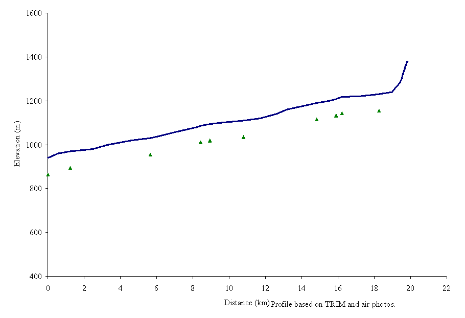
Figure 14. Gradient profile of Summit Creek with ten reaches delineated by triangles.
Reach 1 of Summit Creek is aggraded due to natural sources and possibly historic placer mining activity. Disturbance indicators include extensive areas of un-vegetated mid-channel and point bar, and channel braiding. Historic logging in the early 1980’s on the upper benches does not appear to be impacting the stream channel. However, stream side harvesting in 1969-70 along the lower 500 metres of Summit Creek is classified as Not Satisfactorily Restocked (NSR) and may be having a negative influence on the stream channel (Carmanah, 1997a). Regrowth along the stream side may be compensating for earlier logging activities. Chinook spawn in adjacent reaches of the Antler Creek mainstem and are expected to use reach 1 of Summit Creek as a rearing area. Channel aggradation and a poor riparian buffer may be having a limiting impact on chinook rearing habitats.
Reach 2 is confined with steep valley walls and consists of mainly riffle-pool channel type. Impacts on this reach are associated with several large natural valley wall landslides (Site 12, Carmanah, 1997a) that occur below a 1977 cut block. Riparian zones in this reach are primarily mature conifer. The amount that these slides have been initiated by hydrological changes created by the neighbouring cut block is unknown, although the block was not harvested to the stream valley. The slides appear to be the major sediment source to the lower reaches of Summit Creek and should be assessed as part of the sediment source survey.
Reach 3 contains four exposed mining development sites which were noted along the lower stretch of this reach (Site 13, Carmanah, 1997a). The impact that the mines have on the stream channel is unknown and should be assessed as part of the sediment source survey.
Reaches 4 and 5 of Summit Creek are characterised by low gradient marshy channel type. Historical logging activity along these reaches occurred in 1957 and impacts on the fish habitat are low because of the resilient nature of the channel type. Two Sisters Creek (100-6570-769-062-440) flows into the lower limit of reach 5 of Summit Creek and runs through an area of exposed soils associated with mining activity (Site 14, Carmanah, 1997a; Photo 10). The channel braids across the alluvial fan and drains to a low gradient grassland floodplain of Summit Creek. Sediment may be impacting fish habitat in reach 5. The low gradient meandering channel characteristic of reach 5 buffers the effects of excessive sediment on the stream channel.
Reach 6 is a confined pool riffle reach with cobble substrate. The upper end of the reach borders a swamp complex immediately below the active mine site located along reaches 7 and 8. Several avalanche chutes terminate in the creek and avalanche created debris and logjams span the creek (Site 15, Carmanah, 1997a; Photo 11). There are no forestry-related impacts on this reach and any impacts from the mining site upstream of this reach appear to be mitigated by the swamp meadow stream channel located at the upper end of the reach.
Reaches 7 and 8 run through an existing placer mining operation (Site 16, Carmanah, 1997a). Channel type was riffle-pool with a very low proportion of pools (5%). Rainbow trout reside in this reach and Carmanah (1997a) noted bank destabilisation and lack of habitat for rainbow trout in these reaches. Aerial reconnaissance noted that these reaches were heavily influenced by adjacent mining activity and have likely been relocated several times (per. obs., G. Thorburn, 1997). Riparian buffers are non-existent.
Restoration opportunities on tributaries of Antler Creek include restoring chinook rearing habitats in reach 1, rehabilitating rainbow trout habitat in reaches 7 and 8 and stabilising exposed areas in Sites 12 through 14 through vegetation (Carmanah, 1997a).
Murray and Greenberry creeks
Murray Creek flows into Antler Creek at the upper boundary of reach 4. Greenberry Creek is a tributary to Murray Creek, located 1 km upstream of the confluence of Murray and Antler Creek. Sampling was conducted in upper reaches of the sub-basin and no fish were found (Carmanah, 1997a). However, Murray Creek empties into chinook habitat. There are no barriers to migration into the lower reaches of this creek. Chinook, rainbow and possibly bull trout that inhabit Antler Creek mainstem may access the lower reaches of Murray Creek. It is suspected that chinook use the creek for rearing purposes.
The lower reaches of Murray Creek are steeply incised with high valley walls. Stream channels are riffle-pool in lower reaches graduating to boulder-step-pool in the upper reaches. There are no observed forest related impacts on this sub-basin. Two potential road related slides are evident from the air photos at the confluence of the two creeks on the north headwall below the road (Site 17, Carmanah, 1997a). Potential concentration of surface runoff may be exacerbating a natural slide. This should be assessed in the sediment source survey.
Recommendations:
Restoration opportunities on Murray Creek include bioengineering and slide stabilisation of landslide at Site 17 (Carmanah, 1997a) and culvert assessment.
Pleasant Valley and Grouse Creek
Pleasant Valley is a second-order tributary to Antler Creek. There is no forest development activity in this sub-basin. The major development activity includes the 3100 road corridor, historical and present placer mining. The major channel and fish habitat impacts in this sub-basin occur in reach 1 where Grouse Creek enters Pleasant Valley Creek (Site 5, Carmanah, 1997a). Large amounts of sediment are transported down Grouse Creek from historical and recent placer mining activity. The entire lower stretch and mouth of Grouse Creek consists of a braided alluvial fan (Photo 12). The impact of sediment is evident down through reach 1 of Pleasant Valley Creek and into reach 6 of the Antler mainstem.
Chinook spawning is known to take place in reach 1 of Pleasant Valley Creek up to a steep confined cascade marking the upper limit of the reach. Carmanah (1997a) noted that there was a possibility that chinook spawn in the lower heavily aggraded reach of Grouse Creek.
Major habitat limitations in both reach 1 of Pleasant Valley and Grouse Creek are associated with channel and habitat unit infilling from Grouse Creek sediment. Pool habitat and large organic debris associated habitats are missing in these reaches and as a result holding and rearing habitat may be limited in these creeks.
Upper reaches of Pleasant Creek are characterised by a tortuous meandering stream channel. The 3100 road runs along the valley bottom. Impacts of the road on the stream channel are limited to fine sediment runoff that will have a limited impact on the stream channel due to the buffering capacity of the extensive marshland.
Restoration opportunities on Pleasant Valley Creek include fish habitat rehabilitation for spawning and rearing through pool and LWD placement and riparian restoration and bank stabilisation.
McKenna Creek (100-6570-818-960) flows northeast into Spectacle Lake, which is in the Bowron Lake Provincial Park canoe circuit. The McKenna Creek sub-basin elevation ranges from 914m at Spectacle Lake to 1770m in its headwaters (Figure 16). The mainstem has a length of approximately 10 km with five reaches delineated in the gradient profile (Figure 17).
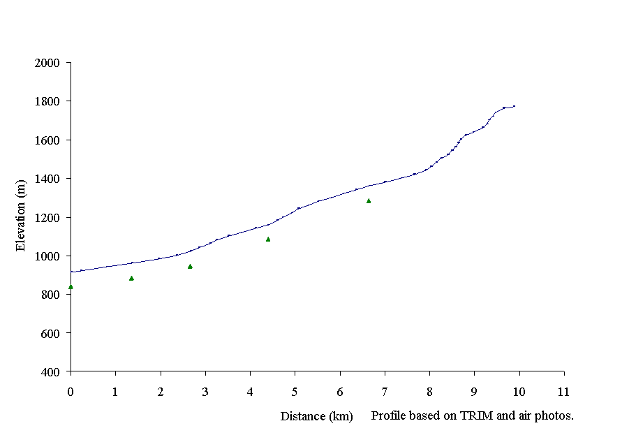
Figure 16. Gradient profile of McKenna Creek with five reaches delineated by triangles.
No fish distribution data is available for McKenna Creek (FISS, 1994), however a fish inventory is proposed for 1998. Kokanee, northern squawfish, peamouth chub, rainbow trout, sucker and whitefish are suspected to be able to access reach 4 of McKenna Creek since the gradient is less than 20%. These fish are found in Spectacle Lake (FISS, 1994).
The McKenna Creek sub-basin has been extensively harvested in the mid 1970’s and early 1980’s along the upper reaches of the creek and along tributaries. Leave strips have been left in several places but at several points clearcut areas join up directly with McKenna Creek. The upper Bowron River Level 1 IWAP indicated that the Equivalent Clearcut Area for McKenna Creek sub-basin was 26%. Based on a highest rating of 1.00, hazard indices were for peak flow was 0.62, surface erosion was 0.75, riparian buffer was 0.52 (Bowron Watershed Committee, 1997).
Habitat condition and preliminary assessment
McKenna Creek is characterised as a confined channel containing cascades and pool habitats with gradients of 3 to 15% in the first six kms. The Habitat Condition Summary form in Appendix C6 provides a general description of the stream habitat conditions. Observations of the stream channel were limited due to the air photo scale, stream cover and the relative size of McKenna Creek. Table 6 provides a brief summary of the preliminary assessment of environmental impacts, assigned priority for level 1 assessment and potential restoration opportunities.
Table 6. Preliminary assessment of environmental impacts, priority for Level 1 assessment and restoration opportunities in McKenna Creek.
|
Sub Basin |
Reach |
Section |
Channel |
Channel |
Habitat |
Upslope |
Potential |
Priority |
Restoration |
|
Name |
Num |
Type* |
Stability† |
Value‡ |
Impact |
Impacts |
Opportunities |
||
|
McKenna Creek 100-6570-818-960 |
2 |
S |
H |
L |
Logging has clearcut to the stream bank in places. |
H |
Re-vegetation or bioengineering of the upslope areas, if necessary. |
||
|
3 |
CPr |
S |
H |
M |
Logging has clearcut to the stream bank in places. Roads that cross the creek should be assessed as potential sediment sources and for fish access |
H |
Re-vegetation or bioengineering of the upslope areas, if necessary. Re-design of the culvert, if found to be a barrier to fish migration. |
||
|
4 |
CPr |
S |
H |
M |
Logging has clearcut to the stream bank in places. |
H |
Re-vegetation or bioengineering of the upslope areas, if necessary. |
||
|
5 |
SPr |
S |
M |
M |
Logging has clearcut to the stream bank in places. |
M |
Re-vegetation or bioengineering of the upslope areas, if necessary. |
The following briefly describes the areas of concern in McKenna Creek sub-basin, based on available data. The upper reaches of McKenna Creek have been harvested. Reach 1 is in parkland. Reaches 2 through 5 have areas where there is inadequate riparian vegetation and should be assessed for impacts on fish habitat. The stream crossings in reaches 3 through 5 should be assessed for fish habitat impacts.
Restoration opportunities on McKenna Creek include re-vegetation or bioengineering of the riparian areas once the creek is determined to have fish habitat concerns. A fish inventory is recommended prior to any restoration work is undertaken.
Summary of Priority Level 1 Recommendations
The following table presents a list of the high and medium priority reaches recommended for field examination in the upper Bowron River watershed. High priority reaches were those having high value fish habitat and adjacent or upstream development that has had, or that is suspected of having, an impact on fish habitat. Medium priority reaches were those that met the above criteria but which have a lower fish habitat value.
Table 7. Summary of reaches recommended for Level 1 FHAP
|
Sub Basin Name |
Reach |
Potential Impacts |
Priority for Level 1 |
Restoration Opportunities |
Species |
|
Indian Point |
|||||
|
1 2 |
The riparian area has been clearcut to the creek side. The bridged road that crosses the creek may be a sediment source and impacting fish habitat. Logjams appear to span the creek channel. |
H |
Re-vegetation or bioengineering of upslope areas and riparian areas at the creek crossings, if necessary. Reconstruction or modification of the bridge, if necessary. |
CH, SK, RB |
|
|
4 |
The bridged road that crosses the creek may be a sediment source and impacting fish habitat. |
H |
Reconstruction or modification of the bridge, if necessary. |
CH, SK, RB |
|
|
5 8 |
The riparian area has been clearcut to the lakeside. |
M |
Re-vegetation or bioengineering of upslope areas and riparian areas at the creek crossings, if necessary. |
CH, SK, RB |
|
|
9 |
The road that crosses the creek may be a sediment source. Portions of the riparian area have been harvested. |
H |
Reconstruction or modification of culverts to allow fish passage if found to be a migration barrier. Assess riparian area for impacts on fish habitat. |
CH, SK, RB suspected |
|
|
Unnamed tributary |
1 |
The riparian area has been clearcut on gullies and smaller tributaries. |
H |
Re-vegetation or bioengineering of upslope areas and riparian areas at the creek crossings, if necessary. |
CH, RB suspected |
|
Unnamed tributary |
1 |
The riparian area has been clearcut on gullies and smaller tributaries. |
H |
Re-vegetation or bioengineering of upslope areas and riparian areas at the creek crossings, if necessary. |
CH, RB suspected |
|
McKitrick Creek |
1 |
The bridged road that crosses the creek may be a sediment source and migration barrier. |
H |
Reconstruction or modification of culverts to allow fish passage if found to be a migration barrier. |
CH, RB suspected |
|
2 |
The riparian area has been clearcut on gullies and smaller tributaries. |
H |
Re-vegetation or bioengineering of upslope areas and riparian areas at the creek crossings, if necessary. |
CH, RB suspected |
|
Sub Basin Name |
Reach |
Potential Impacts |
Priority for Level 1 |
Restoration Opportunities |
Species |
|
Kruger |
|||||
|
1 |
The riparian area has been clearcut on gullies and smaller tributaries. |
H |
Re-vegetation or bioengineering of upslope areas and riparian area, if necessary. |
CH |
|
|
2 |
The riparian area has been clearcut on gullies and smaller tributaries. |
H |
Re-vegetation or bioengineering of upslope areas and riparian area, if necessary. |
CH |
|
|
4 |
The bridged road that crosses the creek may be a sediment source or impacting fish habitat. |
M |
Reconstruction or modification of the crossing, if necessary. Bioengineering of the upslope area, if found to be a sediment source. |
CH suspected |
|
|
Littlefield |
1 |
The riparian area has been clearcut on gullies and smaller tributaries. The stream crossing may be a potential barrier or sediment source. |
H |
Re-vegetation or bioengineering of upslope areas and riparian area, if necessary. Assess the stream crossing for potential habitat impacts. |
CH suspected |
|
2 |
The riparian area has been clearcut on gullies and smaller tributaries. |
H |
Re-vegetation or bioengineering of upslope areas and riparian area, if necessary. |
CH suspected |
|
|
3 |
The riparian area has been clearcut on gullies and smaller tributaries. The stream crossing may be a potential barrier or sediment source. |
H |
Re-vegetation or bioengineering of upslope areas and riparian area, if necessary. Assess the stream crossing for potential habitat impacts. |
CH suspected |
|
|
Towkuh |
|||||
|
Towkuh Creek |
1 |
Channel aggradation from landslide and upstream sediment and debris transport |
H |
Rearing and over-wintering habitat rehabilitation |
CH, RB, BT |
|
Ketchum |
|||||
|
West Creek |
1 |
Upstream streamside harvesting |
H |
Fish habitat rehab. |
CH, RB, BT |
|
2 3 4 |
Historic streamside harvesting, riparian buffer impairment |
H |
Fish habitat and riparian buffer rehab. |
CH, RB, BT |
|
|
Ketcham Creek |
1 2 |
Streamside harvesting and loss of riparian buffer |
H |
Fish habitat and riparian buffer rehab. |
CH, RB, BT |
|
KELP 13 |
1 2 |
Harvesting across stream and culvert barrier to migration |
M |
Restore bull trout access and habitat, riparian rehab. |
BT |
|
Unnamed tributary 100-6570-750-300-195 |
Through stream harvesting and road erosion |
M |
Bank stabilisation and riparian rehab |
BT |
|
|
Unnamed tributary 100-6570-750-300-975 |
Through stream harvesting and road erosion |
M |
Bank stabilisation and riparian rehab |
BT |
|
Sub Basin Name |
Reach |
Potential Impacts |
Priority for Level 1 |
Restoration Opportunities |
Species |
|
Antler |
|||||
|
Antler Creek mainstem |
1 2 3 |
Channel aggradation, isolated rearing habitats, pool infilling, rural development |
H |
Access to isolated side and back channel habitats |
CH, RB, BT |
|
Antler Creek mainstem |
6 |
Channel aggradation from Grouse Creek placer mining activity |
H |
Pool habitat rehabilitation. |
CH, RB, BT |
|
Antler Creek mainstem |
7, 8, 9, 10, 11, 12, 13, 14 |
Adjacent road, historic mining development and loss of riparian buffer |
H |
Habitat rehabilitation |
CH, RB, BT |
|
18 |
Channel relocation associated with historical mining development |
M |
Habitat rehabilitation and channel restoration |
||
|
Summit Creek 100-6570-769-062 |
1 |
Aggradation from natural sources and historic placer mining activity |
H |
Rearing habitat rehabilitation |
CH, RB, BT |
|
7, 8 |
Adjacent mining development, bank destabilisation |
M |
Bank stabilisation and habitat rehabilitation |
RB |
|
|
Pleasant Valley |
1 |
Placer mining and associated channel aggradation |
H |
Bank stabilisation and pool habitat rehabilitation |
CH, RB, BT |
|
Grouse Creek |
1 |
Placer mining and associated channel aggradation |
H |
Bank stabilisation and pool habitat rehabilitation |
CH, RB, BT |
|
Nugget Gulch |
1-2 |
Historic mining development |
H |
Habitat rehabilitation |
BT |
|
McKenna |
|||||
|
2 |
Harvesting to the stream bank in places. |
H |
Re-vegetation or bioengineering of the upslope areas, if necessary. |
KO, RB suspected |
|
|
3 |
Harvesting to the stream bank in places. Roads related migration barriers and sediment generation. |
H |
Re-vegetation or bioengineering of the upslope areas, if necessary. Re-design of the crossing. |
KO, RB suspected |
|
|
4 |
Harvesting to the stream bank in places. |
H |
Re-vegetation or bioengineering of the upslope areas, if necessary. |
KO, RB suspected |
|
|
5 |
Harvesting to the stream bank in places. |
M |
Re-vegetation or bioengineering of the upslope areas, if necessary. |
KO, RB suspected |
The following table summarises the reaches recommended as high and moderate priority Level 1 assessments. Priority assignments may be re-evaluated upon field visitation; if the priority drops, the sites will be evaluated as time permits.
|
Sub Basin Name |
Reach |
Priority for Level 1 |
Length (km) |
Estimated days to complete |
|
Indian Point |
||||
|
Indian Point Creek |
1, 2 |
H |
20.7 |
10 |
|
Indian Point Creek |
4 |
H |
3.4 |
2 |
|
Indian Point Creek |
9 |
H |
1.6 |
0.5 |
|
First unnamed tributary |
1 |
H |
12.8 |
6.5 |
|
Second unnamed tributary |
1 |
H |
3.8 |
2 |
|
McKitrick Creek |
1, 2 |
H |
7.1 |
3.5 |
|
Kruger |
||||
|
Kruger Creek |
1, 2, 3, 4 |
H |
12.5 |
6 |
|
Littlefield Creek |
1, 2, 3 |
H |
11.1 |
5 |
|
Towkuh |
||||
|
Towkuh Creek |
1 |
H |
1.2 |
1 |
|
West & Ketcham creeks |
||||
|
West Creek |
1, 2, 3, 4 |
H |
5.5 |
2.5 |
|
Ketcham Creek |
1, 2 |
H |
8.0 |
4 |
|
Antler Creek |
||||
|
Antler Creek mainstem |
1, 2, 3 |
H |
9.4 |
4.5 |
|
Antler Creek mainstem |
6 |
H |
4.6 |
2 |
|
Antler Creek mainstem |
7 - 14 |
H |
12.6 |
6 |
|
Summit Creek |
1 |
H |
1.2 |
1 |
|
Pleasant Valley |
1 |
H |
1.0 |
0.5 |
|
Grouse Creek |
1 |
H |
1.8 |
1 |
|
Nugget Gulch |
1-2 |
H |
0.9 |
0.5 |
|
McKenna Creek |
||||
|
2-4 |
H |
5.1 |
2.5 |
|
|
Sub-total for high priority assessment |
124.3 km |
62 days |
||
Table 8. continued. Level 1 FHAP Plan.
|
Indian Point |
||||
|
Indian Point Creek |
5, 8 |
M |
3.5 |
2 |
|
Kruger |
||||
|
Kruger Creek |
5, 6, 7, 8 |
M |
15.1 |
7.5 |
|
Ketcham Creek |
||||
|
KELP 13 |
1, 2 |
M |
1.2 |
1 |
|
Antler Creek |
||||
|
Summit Creek |
7, 8 |
M |
1.4 |
1 |
|
McKenna Creek |
||||
|
5 |
M |
3.2 |
1.5 |
|
|
Sub-total for moderate priority assessment |
24.4 km |
13 days |
||
|
TOTAL |
149 km |
75 days |
||
Anonymous. 1995. Fish Stream Identification Guidebook. Forest practices code of British Columbia. Co-published by the Ministry of Environment, Lands & Parks and Ministry of Forests. 39p.
Beaudry, P.1997. The Bowron River Watershed: A case study of a cumulative watershed impact assessment. Forest Research Note PG-09. Ministry of Forests.
Bowron Watershed Committee. 1997. Upper Bowron River Watershed IWAP Level 1: analysis and recommendations. 34pp. Prepared by P. Beaudry and R. Delong, 1996. Upper Bowron River Watershed Interior Watershed Assessment Procedure Level 1: analysis and recommendations. Ministry of Forests. Forest Resources Section. Prince George Forest Region. Internal Publication. 32pp
Carmanah Research Ltd. Brydges, K.D., S. Luzzi, T. Davies and M. Burrell. 1997a. Draft report: a reconnaissance Fisheries Inventory of the Antler Creek watershed. Submitted to West Fraser Mills Ltd., Quesnel Division, by Carmanah Research Ltd., Victoria, B.C. 61p plus appendices.
Carmanah Research Ltd. Brydges, K.D., S. Luzzi, T. Davies and M. Burrell. 1997b. Draft report: a reconnaissance Fisheries Inventory of Towkuh Creek and Ketcham Creek Watershed. Submitted to West Fraser Mills Ltd. Quesnel Division, by Carmanah Research Ltd. Victoria, B.C. 85p plus appendices.
Johnston, N.T., and P.A. Slaney. 1996. Fish Habitat Assessment Procedures. Watershed restoration technical Circular No. 8. Watershed Restoration Program. Ministry of Environment, Lands and Parks and Ministry of Forests. 97pp.
Levson and Giles. 1993. Geology of tertiary and quaternary gold-bearing placers in the Cariboo Region, British Columbia (93 A, B, G, H). B.C. Ministry of Energy, Mines and Petroleum Resources. Geological Survey Branch Bulletin 89. 202pp.
Rood, K.M. and R.E. Hamilton. 1995. Hydrology and water use for salmon streams in the upper Fraser Habitat Management Area, British Columbia. Fraser River Action Plan. Department of Fisheries and Oceans. Canadian Manuscript Report of Fisheries and Aquatic Sciences No.2294.
Rowland, D.E. and L.B. McDonald. 1996. Salmon Watershed Planning process for the Fraser River Basin with in the Cariboo-Chilcotin Land Use Plan (CCLUP) area. Prepared for Department of Fisheries and Oceans, Habitat Management Unit, Prince George, B.C. and the Fraser River Action Plan, Vancouver, BC. 375p.
Appendix A General information for the upper Bowron River
Appendix A1 Watershed and Tenure Information for upper Bowron River
|
Watershed name |
Upper Bowron River |
|
Gazetteer name |
Bowron River |
|
Local name |
N/A |
|
Hierarchical Watershed Code (HWC) |
100-6570 |
|
Stream mouth UTM Co-ordinates (Zone. Easting. Northing) |
10.577092.5990487 |
|
Stream order at 1: 50,000 map scale |
5 |
|
NTS 1: 50,000 map sheets |
93 B/13, 93 B/14, 93 G/03, 93 G/04 93 G/05, 93 G/06 |
|
BSGS 1: 20,000 map sheets |
93 H.003, 93 H.004, 93 H.005, 93 H.013. 93 H.014, 93 H.015, 93 H.023, 93 H.024, 93 H.033, 93 H.034, 93 H.035 |
|
MoF Region and Districts |
Quesnel (61) Prince George |
|
Forest Tenure |
West Fraser Mills Ltd. Northwood Pulp and Timber Ltd. |
Named sub-basins as described by West Fraser Mills Ltd. and the creeks and rivers contained within each sub-basin with their hierarchical watershed codes and Universal Transverse Mercator co-ordinate (Zone. Easting. Northing).
|
System |
HWC |
UTM |
|
|
Indian Point Creek |
100-6570-632 |
10.595200.5922524 |
Indian Lake Indian Point Lake |
|
Kruger Creek |
100-6570-632-567 |
10.607227.5914968 |
Kruger Lake |
|
Towkuh Creek |
100-6570-715 |
10.601978.5903653 |
|
|
West Creek |
100-6870-750 |
10.603087.5903653 |
|
|
Ketcham Creek |
100-6570-750-300 |
10.601538.5902739 |
|
|
Antler Creek |
100-6570-769 |
10.604569.5899866 |
|
|
Summit Creek |
100-6570-769-062 |
10.604569.5899866 |
|
|
McKenna Creek |
100-6570-818-960 |
10.619279.5885059 |
Nearest community, approximate distance (km), type of access to Upper Bowron watershed
Barkerville, end of Highway 26
Wells, 6 km north-west of Barkerville on Highway 26
Recreational areas in the Upper Bowron watershed
Bowron Lake Park
Appendix A2
Fish species documented to date in the upper Bowron River FHAP study area.
|
Common name |
Scientific name |
BC Fish Codes |
|
Bull trout |
Salvelinus confluentus |
BT |
|
Burbot |
Lota lota |
BB |
|
Chinook salmon |
Oncorhynchus tshawytscha |
CH |
|
Kokanee salmon |
Oncorhynchus nerka |
|
|
Lake chub |
Couesius plumbeus |
LKC |
|
Long nose sucker |
Catostomus catostomus |
LNU |
|
Mountain whitefish |
Prosopium williamsoni |
MW |
|
Northern squawfish |
Ptycheilus oregonensis |
NSC |
|
Peamouth chub |
Mylocheilus caurinus |
PCC |
|
Rainbow trout |
Oncorhynchus mykiss |
RB |
|
Red side shiner |
Richardsonius balteatus |
RBC |
|
Sculpin, general |
Cottus sp. |
CC |
|
Sockeye Salmon |
Oncorhynchus nerka |
SK |
|
Sucker, general |
Catostomus sp. |
SU |
|
Whitefish, general |
Prosopium sp. |
WG |
Appendix B Overview Assessment – Fish distribution summary forms
1 Indian Point Creek
2 Kruger Creek
3 Towkuh Creek
4 West and Ketcham Creek
5 Antler Creek
6 McKenna Creek
Codes use on tables:
FISS refers to the Fish Information Stream Summary maps, 1994.
ABM refers to the Aquatic Biophysical Maps, 1997.
EL = electroshocking
UN = unknown
K= known
K* = known spawning
S = suspected (undetermined)
Appendix C Overview Assessment – Habitat condition summary forms
1 Indian Point Creek
2 Kruger Creek
3 Towkuh Creek
4 West and Ketcham Creek
5 Antler Creek
6 McKenna Creek
Refer to Johnston and Slaney (1996) for codes used on tables.