
Overview Report
Fish Habitat Assessment Procedure
Cottonwood River Watershed
FRBC Project 97CAR1
Prepared for
West Fraser Mills Ltd.
P.O. Box 6000
Quesnel, BC, V2J 3J5
by
Roberta Pedersen, M.Sc., R.P. Bio., and Guy Thorburn, B.Sc.
Carmanah Research Ltd.
Building 4, 203 Harbour Road
Victoria, B.C. V9A 3A2
Telephone: (250) 920-9900 Facsimile: (250) 920-9800
Http:\\www.carmanah.com Email: fish@carmanah.com
March 1998
Carmanah Research Ltd. conducted an Overview Fish Habitat Assessment Procedure of the Cottonwood River watershed. The Overview is the first step in the Fish Habitat Assessment Procedure, a process that identifies opportunities for fish habitat restoration. The objective of this document is to recommend impacted stream reaches for Level 1 fish habitat assessment. Fish habitat was assessed using aerial photographs supported by records of fish inventory, forest harvesting, and analysis of Terrain Resource Inventory Maps. This assessment identifies site-specific habitat concerns and provides a preliminary assessment of the viability of habitat restoration work in the drainage. Several impacted areas have been defined as requiring Level 1 assessment.
The Cottonwood River watershed comprises a study area of 247,363 hectares in the Central Interior of British Columbia. The Cottonwood River flows west into the Fraser River, north of Quesnel. Twelve sub-basins were assessed for fish distribution and habitat conditions, based on boundaries provided by West Fraser Mills Ltd. The sub-basins, from the confluence of Cottonwood and Fraser rivers, are the Cottonwood Residual, Ahbau Creek, Nelson Kenny Creek, Umiti Creek, John Boyd Creek, Lightning Creek, Swift River, Sovereign Creek, Victoria Creek, Reddish Creek, McMartin and Little Swift River. Habitat impacts in the Cottonwood River watershed are the result of mining, forestry, linear (roads, railways, hydrolines) and agriculture activities.
The Cottonwood Residual sub-basin is defined, in its upper limit, by the confluence of Lightning Creek and Swift River. The sub-basin extends 58 km downstream to the Cottonwood and Fraser River confluence. Chinook, pink, coho and kokanee salmon use the Residual area for migration and rearing with some spawning and incubation. Fish habitat in this area is ample due to the sinuosity of the river channel, but forest harvesting has removed the riparian vegetation from several portions of the riverside. Forestry access roads may be contributing to the high level of surface erosion seen in the sub-basin that, in turn, may be impacting fish habitat. The size and sinuosity of Cottonwood River make the mainstem a hazardous place to work, so no assessment work in the mainstem is recommended.
Chinook and kokanee salmon and rainbow trout are found in Ahbau Creek up to Lodie Lake. Fish habitat concerns in Ahbau Creek are related to linear (i.e. roads, railways and hydrolines) developments and forest harvesting along some mainstem reaches and on the tributaries. Level 1 assessment is recommended for several reaches.
Nelson Kenny Creek, a tributary of Ahbau Creek, is designated as a separate sub-basin. The creek has chinook salmon habitat in the lower reaches, and it is recommended that a fish inventory be conducted to determine the presence or absence of fish above reach 2. Fish habitat concerns are related to linear development, forestry and agriculture activities. Level 1 assessment is recommended for reaches 1, 2 and 3.
Umiti Creek is expected to contain chinook salmon, since there appear to be no barriers to migration. Potential fish habitat concerns are related to clear cutting to streambanks in several areas and sediment generation from forest access roads. Several reaches have been recommended for Level 1 assessment.
John Boyd Creek contains chinook and rainbow trout throughout its mainstem. Fish are suspected of using at least the first reach of tributaries for rearing and spawning. Forestry activities that have impacted the fish habitat in John Boyd Creek and tributaries include clear cutting of the riparian areas and sediment input from roads that cross the creek. The reaches containing chinook have been recommended for Level 1 assessment.
Forestry, mining, linear and recreational developments have impacted the fish habitat in Lightning Creek. Since Lightning Creek contains chinook, rainbow trout and bull trout, most of sub-basin is recommended for Level 1 assessment.
Swift River contains spawning, incubation, rearing and migration habitat for chinook salmon. Forestry and mining activities have impacted the fish habitat by increasing sediment input from roads and removal of the riparian vegetation from the riverside. Several reach-specific recommendations have been made.
Both forestry and mining activities have impacted the fish habitat in Sovereign Creek. The lower reaches of this chinook-bearing creek have been recommended for Level 1 assessment. Several reach-specific concerns have been flagged for field inspection.
Concerns about the fish and fish habitats in Victoria Creek are few. The low gradient of the stream has absorbed the effects of the limited timber harvesting that has occurred in this sub-basin. Several reach-specific recommendations have been made.
Fish habitat concerns in Reddish Creek have a high priority. The timber harvesting activity adjacent to Reddish Creek has potential sediment related impacts on the mainstem. Fontaine Creek, a tributary of Reddish Creek, has significant historical logging that has impacted the riparian zone. Impacts to fish habitat and riparian areas are evident along 11 km of the stream. Level 1 assessment is recommended for several reaches.
McMartin Sub-basin, formed by the upper reaches of the Swift River, contains rainbow and bull trout. Concerns about fish and fish habitats are few.
Fish habitat concerns in Little Swift River have a high priority for several reaches of the stream, mostly related to forest harvesting activities. Mining activities along reaches 2 and 3 of Little Swift River have impacted the mainstem by increasing sediment input. The stream crossing should be assessed to quantify the impacts on fish habitat.
This overview report of the Cottonwood River Fish Habitat Assessment Procedure was conducted under the auspices of the Forest Renewal British Columbia Watershed Restoration Program.
Guidance and direction for this project was provided by Mr. Al Hunter, Forester, at West Fraser Mills Ltd., Quesnel Division, and Mr. M. Parker, Watershed Restoration Specialist, Ministry of Environment, Lands & Parks, Williams Lake, B.C.
Carmanah fisheries biologists Mr. K. Brydges and technician Mr. H. Liebe-McGinnis reviewed and made suggestions about the report.
Geographic Information Systems specialist Mr. A. Dewey provided the maps for the figures.
Executive Summary *
Acknowledgments *
Table of Contents *
List of Tables *
List of Figures *
List of Photos *
List of Appendices *
Introduction *
Study area *
Resource use *
Biogeoclimatic zones *
Climate *
Fish use *
Methods *
Demarcation of study area *
Existing information sources *
Delineation of stream reaches *
Fish use *
Overview assessment of habitat conditions *
Preliminary fish habitat assessment and potential restoration strategies *
rESULTs - Overview Assessment By Sub-Basin *
Cottonwood Residual *
Ahbau Creek *
Nelson Kenny Creek *
Umiti Creek *
John Boyd Creek *
Lightning Creek *
Swift River *
Sovereign Creek *
Victoria Creek *
Reddish Creek *
McMartin Sub-basin *
Little Swift River *
Summary of recommendations for priority Level 1 Assessments *
References *
Table 1. Preliminary assessment of environmental impacts, priority for Level 1 assessment and restoration opportunities in Cottonwood Residual. *
Table 2. Preliminary assessment of environmental impacts, priority for Level 1 assessment and restoration opportunities in Ahbau Creek. *
Table 3. Preliminary assessment of environmental impacts, priority for Level 1 assessment and restoration opportunities in Nelson Kenny Creek. *
Table 4. Preliminary assessment of environmental impacts, priority for Level 1 assessment and restoration opportunities in Umiti Creek. *
Table 5. Preliminary assessment of environmental impacts, priority for Level 1 assessment and restoration opportunities in John Boyd Creek. *
Table 6. Preliminary assessment of environmental impacts, priority for Level 1 assessment and restoration opportunities in Lightning Creek. *
Table 7. Preliminary assessment of environmental impacts, priority for Level 1 assessment and restoration opportunities in the Swift River *
Table 8. Preliminary assessment of environmental impacts, priority for Level 1 assessment and restoration opportunities in Sovereign Creek. *
Table 9. Preliminary assessment of environmental impacts, priority for Level 1 assessment and restoration opportunities in Victoria Creek. *
Table 10. Preliminary assessment of environmental impacts, priority for Level 1 assessment and restoration opportunities in Reddish Creek. *
Table 11. Preliminary assessment of environmental impacts, priority for Level 1 assessment and restoration opportunities in the McMartin Sub-basin. *
Table 12. Preliminary assessment of environmental impacts, priority for Level 1 assessment and restoration opportunities on the Little Swift River. *
Table 13. Summary of Level 1 FHAP recommendations *
Table 14. Level 1 FHAP plan *
Figure 1. The Cottonwood River watershed is located on the interior plateau of central British Columbia (inset). Overview Fish Habitat Assessment Procedure study area is 247, 363 ha and is divided into 12 sub-basins. *
Figure 2. Cottonwood River hydrograph for 1996 for station 08KE009 shows that the maximum water flow occurs in April and the minimum occurs in January (data provided by Environment Canada, 1997). *
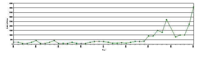
Figure 3. Escapement data for chinook salmon on Cottonwood River over a 40 year period (data provided by L. Godbout, Stock Assessment Division, 1997). *
Figure 4. Cottonwood Residual of the Cottonwood River watershed drains an area of 30, 741 hectares as it flows west toward Fraser River. Fish distribution is based on Overview assessment. *
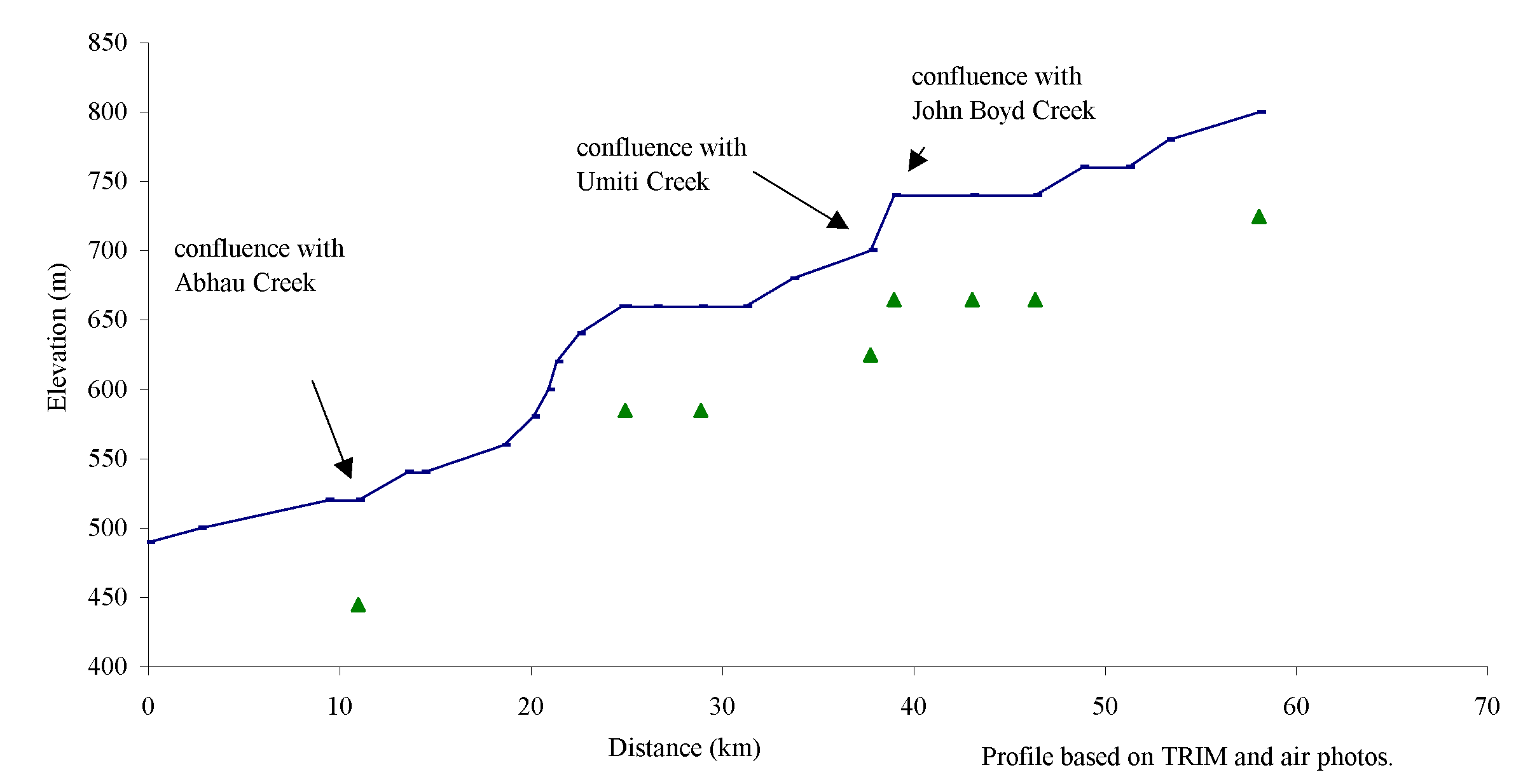
Figure 5. Gradient profile of the Cottonwood Residual from confluence with the Fraser River to 58 km upstream with eight reaches delineated by triangles. *
Figure 6. Ahbau and Nelson Kenny sub-basins. Ahbau sub-basin drains an area of 42, 920 ha as it drains southwest into Cottonwood River while Nelson Kenny sub-basin drains an area of 7, 923 ha. Fish distribution is based on the overview assessment. *
Figure 7. Gradient profile of Ahbau Creek with 15 reaches delineated by triangles. *
Figure 8. Gradient profile of Nelson Kenny Creek with six reaches delineated by triangles. *
Figure 9. Umiti Creek drains an area of 14, 876 ha as it flows west into the Cottonwood River. Fish distribution is based on the Overview assessment. *
Figure 10. Gradient profile of Umiti Creek with five reaches delineated by triangles. *
Figure 11. John Boyd Creek drains an area of 11, 046 ha and flows west into the Cottonwood River. Fish distribution is based on the Overview assessment. *
Figure 12. Gradient profile of John Boyd Creek with six reaches delineated by triangles. *
Figure 13. Lightning Creek drains an area of 24, 940 ha as it flows west into the Cottonwood River. Fish distribution is based on the Overview assessment. *
Figure 14. Gradient profile of Lightning Creek with six reaches delineated by triangles. *
Figure 15. The Swift River sub-basin drains an area of 36, 277 ha and flows west to form the Cottonwood River when it meets with Lightning Creek. Fish distribution is based on the Overview assessment. *
Figure 16. Gradient profile of the Swift River (excluding the upper section that is profiled under the McMartin sub-basin) with 12 reaches delineated by triangles. *
Figure 17. Sovereign Creek drains an area of 11, 249 ha and flows west into the Swift River. Fish distribution is based on the Overview assessment. *
Figure 18. Gradient profile of Sovereign Creek with eleven reaches delineated by triangles. *
Figure 19. Victoria Creek drains an area of 29,949 ha and flows west into the Swift River. Fish distribution is based on the Overview assessment. *
Figure 20. Gradient profile of Victoria Creek with 12 reaches delineated by triangles. *
Figure 21. Reddish Creek drains an area of 7,245 ha and flows south into the Swift River. Fish distribution is based on the Overview assessment. *
Figure 22. Gradient profile of Reddish Creek with three reaches delineated by triangles. *
Figure 23. Gradient profile of Fontaine Creek with six reaches delineated by triangles. *
Figure 24. McMartin sub-basin is formed from the upper 38 km of the Swift River and drains an area of 16, 080 ha. Fish distribution is based on the Overview assessment. *
Figure 25. Gradient profile of McMartin Sub-basin, upper 37 km of Swift River with nine reaches delineated by triangles. *
Figure 26. The Little Swift River flows south into the Swift River and drains an area of 13, 118 ha. Fish distribution is based on the Overview assessment. *
Figure 27. Gradient profile of Little Swift River with 15 reaches delineated by triangles. *
Photo 1. A bank failure on upper Umiti Creek lies next to a clearcut area. The creek flow is toward the bottom of the photograph. *
Photo 2. Bank failures, as seen in reach 1, are a frequent occurrence on Sovereign Creek. The creek flows right to left. *
Photo 3. A stream crossing in reach 1 that may be a sediment source to the Reddish Creek mainstem. *
Photo 4. The riparian area has been clearcut along reach 4 of Fontaine Creek. *
Cottonwood Residual
Appendix A Watershed, Tenure and Fish Species of the Cottonwood River
Recreational areas in the Cottonwood River watershed
Appendix B Overview Assessment - Fish distribution summary forms
Appendix C Overview Assessment - Habitat condition summary forms
This document presents the findings of the Overview Fish Habitat Assessment Procedure (FHAP) for the Cottonwood River watershed. As part of the Watershed Restoration Program (WRP), the FHAP attempts to identify opportunities and appropriate techniques to restore and rehabilitate impacted fish habitat to increase depressed stocks of fish in streams (Johnston and Slaney, 1996). The Overview is the first part of the FHAP in that it uses available documents and data to provide a preliminary indication of the factors that limit fish production and fish habitat in the watershed. The Overview FHAP, an office-based activity, focuses on streams larger than third order. The results of the Overview can be used to direct subsequent field surveys on potentially impacted areas. Level 1 habitat surveys will eventually lead to the prescription and construction of instream rehabilitation and restoration projects.
The Cottonwood River, located northeast of Quesnel, flows west into the Fraser River from the Interior Plateau of central British Columbia (Figure 1). The joining of Swift River and Lightning Creek forms Cottonwood River. The Cottonwood River watershed drains an area of 247,363 hectares (ha) from a portion of the Interior Plateau called the Quesnel Highlands. The average elevation increases towards the eastern boundary of the watershed. The eastern boundary of the watershed abuts the Willow and Bowron river watersheds, while the southern and western boundaries abut the Quesnel River watershed.
Twenty-seven streams constitute the 12 sub-basins in the watershed, which were defined by West Fraser Mills Ltd. (Appendix A1). In order of confluence with the mainstem from the mouth, the sub-basins are Cottonwood Residual, Ahbau, Umiti, John Boyd and Lightning creeks and Swift River. Smaller tributaries to these sub-basins form separate sub-basins, as designated by West Fraser Mills Ltd. Nelson Kenny Creek flows into Ahbau Creek. Sovereign, Victoria and Reddish creeks and Little Swift River flow into the Swift River. The upper section of the Swift River, above its confluence with the Little Swift River, is designated as the McMartin Sub-basin. Sub-basin information can be found in Appendix A1.
Resource use
Settlements within the Cottonwood River watershed form a population base of less than 500 people. Hamlets in the watershed include Cottonwood, Wingdam and Cinema. Highway 97 passes over sections of the Cottonwood Residual and Ahbau Creek. Highway 26, which provides access to Wells, Barkerville and Bowron Lake Provincial Park, follows Lightning Creek before crossing into the Willow Creek watershed. Transmission lines, underground pipeline right-of-ways and railways, referred to as linear developments, also pass through the Cottonwood River watershed. Popular recreation destinations in the watershed are Cottonwood Provincial Park, Troll Mountain Ski Hill, Hush Lake cross country ski trails and many forest recreation sites.
Forestry and mining are the main economic endeavors in the Cottonwood River watershed. The watershed lies within the boundaries of the Quesnel and Prince George Forest Districts. Forest harvesting has occurred in all sub-basins. The major operating timber licensees in the watershed are West Fraser Mills Ltd., Weldwood of Canada Ltd. and Dunkley Forest Products. The provincial Small Business Forest Enterprise Program also operates in the watershed. Placer and hydraulic mining has taken place in the watershed since 1860. This has been identified as having a significant impact on the stream systems in the Cottonwood River watershed (AIM, 1996; Rowland and McDonald, 1996).
Mining within the watershed has occurred for the past 100 years and continues today. There are upwards of 100 mineral and placer claims in the watershed boundaries. The majority of historic mining activity has been in the form of placer gold mining of paleochannels. The abundant glacial and glaciofluvial materials have yielded many million ounces of gold; however, some underground mining has also occurred. The Lightning and John Boyd Creek sub-basins contain the most concentrated areas of mining related disturbance in the Cottonwood system (Chapman and Dobson, 1997). Placer mining requires the disturbance of surficial materials and has resulted in obvious and significant impacts on both the material constitution and stability of creek channels. Hydraulic mining has also resulted in surficial disturbance. The level of resultant sedimentation and consequent channel changes remains undetermined.
Two biogeoclimatic zones dominate the study area. These zones are the Sub-Boreal Spruce Zone (SBS) and the Engelmann Spruce-Subalpine Fir Zone (ESSF). The SBS Zone is found in the low- to mid-elevation portions of the study area. It has a continental climate characterized by warm, moist summers with long growing seasons and cool winters (Meidinger and Pojar, 1991). Mature forest containing the hybrid white spruce and subalpine fir covers much of the SBS landscape. The ESSF Zone occupies the middle to upper elevations of the Cottonwood River watershed. As it borders on the lower elevation SBS Zone, it has similar but cooler climate. A distinctive feature of the ESSF landscape is extensive young and maturing forests of subalpine fir mixed with subalpine meadows. There is a small portion of Alpine Tundra Zone in the high elevations along the eastern boundary of the Cottonwood River watershed.
The Cottonwood River watershed is affected by continental climates. Most of the annual precipitation falls as snow in the winter months. Summer rainstorms are typically of short duration with high intensity showers. The Water Survey of Canada operates four gauging stations in the watershed for measuring seasonal changes in water flow. These are the Swift Creek gauging station 08KE003, Cinema gauging station 08KE009, Wingdam gauging station 08KE004 and Little Swift River gauging station 08KE024. Mean annual flow for the watershed is 26.0 m3s-1 (Rowland and McDonald, 1996). Average maximum flow takes place during April and May with flows measured at 234.0 m3s-1. Average minimum or low water flow periods occur during December through March. Summertime and wintertime 7-day low water flows are 4.15 m3s-1 in September and 3.51 m3s-1 in December to January respectively. Figure 2 provides the hydrograph for 1996 on the Cottonwood River.
Figure 2. Cottonwood River hydrograph for 1996 for station 08KE009 shows that the maximum water flow occurs in April and the minimum occurs in January (data provided by Environment Canada, 1997).
Fish use
The Cottonwood River watershed provides migration, spawning, incubation and rearing habitat for rainbow trout (Oncorhynchus mykiss), coho (O. kisutch), pink (O. gorbuscha) and chinook salmon (O. tshawytscha) (Fish Information Stream Summary (FISS), 1994). Chinook salmon are present in the lower reaches of the Swift River, Lightning, Sovereign and Victoria creeks (Imhof and Sutherland, 1995). A waterfall on the Swift River may limit migration of chinook salmon (Rowland and McDonald, 1996). Bull trout (Salvelinus confluentus) and Dolly Varden (S. malma) are distributed throughout the Swift and Little Swift rivers and Lightning Creek (FISS, 1994). Mountain whitefish (Prosopium williamsoni) have also been noted in the Swift River and Victoria Creek (Carmanah, 1996c).
The main commercial anadromous species in this watershed is chinook salmon, while pink and coho salmon are also found in the river (Fish Habitat Inventory and Information Program, 1990). Maximum escapement of chinook was 4690 fish in 1994, with an average escapement of 194 from 1969 to 1980 and 1175 between 1981 and 1992 (Rood and Hamilton, 1995). The escapement profile for chinook salmon is provided in Figure 3. Fish species found in the watershed are listed in Appendix A2. The distribution of salmon and game fish, or target fish, is described by sub-basin in Section 3 and in the appendices.
Forest Renewal British Columbia (FRBC) has funded several projects directed toward improving the breadth and quality of information for the Cottonwood River watershed. Fish inventories on the Victoria, Sovereign and Reddish creek sub-basins improved assessments of fish habitat by providing interpretations of habitat impacts. Carmanah Research Ltd. (1996) completed the fish inventory reports. Other Watershed Restoration oriented projects in the Cottonwood River watershed include:
The methods used in the Overview FHAP comply with those outlined in pages 14 to 32 of Watershed Restoration Technical Circular No. 8 (Johnston and Slaney, 1996). The synopsis below presents a summary of the steps in the Overview assessment. Base resources including air photographs, Terrain Resource Inventory Management maps (TRIM) and files were provided by the West Fraser Mills Ltd., Quesnel, and the Ministry of Environment, Lands and Parks (MELP), Cariboo Region, Williams Lake.
Cottonwood Residual and 27 streams within the watershed were selected for analysis of target fish distribution, forest harvesting activity and fish habitat concerns. Gradient profiles of the Cottonwood River, sub-basins and selected tributaries were generated from 1:20,000 hard copy TRIM. Johnston and Slaney (1996) suggested using 1:50,000 NTS maps, but the 1:20,000 maps provided a more accurate description of the true stream lengths and profiles.
Tom Wilkinson, Ministry of Environment, Lands & Parks Regional Fisheries/Habitat Inventory Specialist, Williams Lake, B.C., was contacted for further information on fish abundance and distribution, forestry, water use and parks and protected areas.
Preliminary stream reaches boundaries, or breaks, were based on the following equally-weighted criteria:
Waterfalls were also considered to be reach breaks. Within reaches, additional subdivisions identified as sections were made based on changes in riparian vegetation or stand characteristics.
The available information on fish distribution and abundance is presented on the sub-basin maps and in Appendix B (Form 1 from the Overview FHAP). The data are discussed in the overview assessment by sub-basin. Fish distribution on the maps is subdivided into known fish-bearing reaches, potential fish-bearing reaches (undetermined) and non-fish-bearing reaches. Potential fish-bearing reaches were defined based on proximity to known fish-bearing reaches where no barriers, including gradient barriers, to fish access were apparent. Reaches specified as non-fish-bearing were derived form Forest Practices Code inventory data and, where unavailable, fish distribution was deducted based on the presence of a barrier to fish migration or habitat quality (poor fish production potential). Where inventory data was unavailable, the reach was also labeled undetermined.
Overview assessment of habitat conditions
The 1:15,000 scale air photo coverage used was flown in 1991, 1995 and 1996. With the exception of larger streams, fish habitat conditions were often obscured due to the small scale of the air photos. Habitat conditions, which were observable at the scale of photography, are tabulated in Appendix C and discussed in the overview section (Forms 2 and 3 from the Overview FHAP). A half day reconnaissance helicopter overflight of portions of the study area was conducted on August 27, 1997. The surveys supplemented the office-based overview work. Still and video photodocumentation was compiled during the over-flight.
Preliminary fish habitat assessment and potential restoration strategies
We recommended that fish sampling or a fish inventory be performed where data is currently unavailable. If air photo analysis revealed areas of concern, we suggested potential fish habitat restoration strategies. Reaches were prioritized for assessment based on the following criteria:
If no impacts were observed during the Overview assessment, the reaches were not discussed or prioritized. Level 1 assessments are recommended for all reaches that are impacted, but high priority reaches should be assessed before those reaches that are identified as medium or low priority. Since the areas of concern are identified from office-based activities, field verification is necessary to confirm recommendations. Priority assignments may be re-evaluated upon field visitation; if the priority drops, additional sites should be evaluated as time permits.
rESULTs - Overview Assessment By Sub-Basin
The Cottonwood River (100-4811) is formed by the joining of Lightning Creek and Swift River as it flows west to Fraser River (Figure 4). The Cottonwood Residual is an area that includes portions of Cottonwood River that are not part in any other sub-basin. It drains an area of 30,741 hectares (Dobson, 1996). The Cottonwood Residual has a mainstem length of 58 km with eight reaches delineated in the gradient profile (Figure 5). Major sub-basins that empty flow into the Cottonwood River are Ahbau Creek, Umiti Creek, John Boyd Creek, Lightning Creek and Swift River. The Water Survey of Canada station 08KH009, near Cinema, recorded the mean annual discharge as 28.7 m3s-1 (data provided by Environment Canada, 1997). Wintertime low water flows, occurring in December and January, were 3.51 m3s-1 and summer-time low water flows, occurring in September, were 4.15 m3s-1 (Rowland and McDonald, 1996).
According to FISS (1994), chinook, pink, coho and kokanee salmon are found throughout the area (Appendix B1; Figure 4). Escapement data for chinook salmon record a maximum of 2700 fish (Rowland and McDonald, 1996). Dolly Varden (Salvelinus malma), bull trout (S. confluentus), mountain whitefish (Prosopium williamsoni), suckers (Catostomus sp.) and northern squawfish (Ptycheilus oregonensis) are also found in the Residual area.
 Forest harvesting
has occurred primarily along tributaries, but some impacts have been identified
along the mainstem of the Cottonwood Residual. The Cottonwood/Swift River Interior
Watershed Assessment Procedure (IWAP) indicated that the Equivalent Clearcut
Area (ECA) for the Cottonwood Residual was 40% (Dobson, 1996). Based on a highest
rating of 1.00, the hazard index for peak flow was 0.36, surface erosion was
0.88, riparian buffer was 1.00 and landslide was 0.75. Peak flow index represents
a low hazard and indicates that the channel is relatively stable. The hazard
indices of surface erosion and riparian buffer for the sub-basin are rated as
high due mostly to the high number of roads and active crossings and the high
level of logging along the streamside. The landslide hazard index is related
to numerous bank failures along the Cottonwood River. Dobson (1996) recommended
that field assessment of the bank and upslope areas of the Cottonwood River
would determine if forestry developments have increased the frequency of bank
failures. These areas should also be assessed for impacts on fish habitat.
Forest harvesting
has occurred primarily along tributaries, but some impacts have been identified
along the mainstem of the Cottonwood Residual. The Cottonwood/Swift River Interior
Watershed Assessment Procedure (IWAP) indicated that the Equivalent Clearcut
Area (ECA) for the Cottonwood Residual was 40% (Dobson, 1996). Based on a highest
rating of 1.00, the hazard index for peak flow was 0.36, surface erosion was
0.88, riparian buffer was 1.00 and landslide was 0.75. Peak flow index represents
a low hazard and indicates that the channel is relatively stable. The hazard
indices of surface erosion and riparian buffer for the sub-basin are rated as
high due mostly to the high number of roads and active crossings and the high
level of logging along the streamside. The landslide hazard index is related
to numerous bank failures along the Cottonwood River. Dobson (1996) recommended
that field assessment of the bank and upslope areas of the Cottonwood River
would determine if forestry developments have increased the frequency of bank
failures. These areas should also be assessed for impacts on fish habitat.
Carr et al. (1996) described 193 sediment sources in Cottonwood Residual sub-basin; 73% are man-made with 49% associated with forest development in their survey of sediment sources. Five of 71 forestry-related sources fall into the high-risk category and are associated with forest access roads, not logging (Carr et al., 1996). There are eight high-risk problem areas associated with mining activity and six with agricultural development in the Cottonwood Residual sub-basin. There appears to be a significant amount of sediment generated from natural stream instability. Carr et al. (1996) did not specify whether this was a function of natural fluvial processes, which appears to be most likely, or that forest harvesting, mining, agricultural and rural development have impacted the river channel.
Highways 97 from Quesnel and 26 from Barkerville provide access into Cottonwood Residual area. Several logging, mining, recreational and agricultural roads branch off the highway.
Habitat condition and preliminary assessment
Cottonwood River flows through gently rolling undissected uplands. The river channel meanders and forms braided back channels and bare sandbars throughout its 58 km length. The Habitat Condition Summary form in Appendix B1 gives a general description of the stream habitat conditions. Riffles, pools and bars with gravel and woody debris form the channel. Large bank failures along the mainstem are associated with forestry, agricultural and linear developments and natural slumping (Carr et al., 1996). Gullies and tributaries of the Cottonwood River area are also prone to bank failures. These affect the mainstem of the river by increasing sediment input that alters the stream channel and riparian area. Fish habitat concerns include roads and right-of-ways that cross the river in several reaches and a lack of riparian vegetation along reaches 7 and 8. Table 1 gives a brief summary of the preliminary assessment of environmental impacts, assigned priority for Level 1 assessment and potential restoration opportunities.
The following briefly describes areas of concern on Cottonwood Residual on a reach basis, based on available information. In reaches 1 and 2 rural developments have encroached upon the streambank and appear to be causing slumping. Reaches 2, 3, 4, 5 and 8 contain bridged river crossings that should be assessed for fish habitat impacts due to sediment input and channel confinement. Reach 2 is spanned by the three-line hydroline right-of-way, which may cause sediment input due to brush removal. The riparian vegetation in reach 5 has regenerated since harvesting in 1967 (pers. comm., L. Chevrette, Carmanah, 1997). In reach 6, a conifer-deciduous mix of vegetation communities now dominates riparian areas harvested in 1956 and 1966, while the flood plain vegetation is dominated by deciduous species. The riverbank has been exposed by mining activity in reach 6. The area should be assessed for fish habitat impacts and stabilized to limit slumping. Forest harvesting activities have removed riparian vegetation along the streambanks in reaches 7 and 8. Re-vegetation and bank stabilization opportunities should be identified.
|
Sub Basin |
Reach |
Channel |
Channel |
Habitat |
Upslope |
Potential Impacts |
Priority‡ |
Restoration |
|
Name |
Num |
Type* |
Stability† |
Value‡ |
Impact‡ |
Opportunities |
||
|
Cottonwood Residual 100-4811 |
1 |
RPgw |
S |
H |
H |
Rural developments may have encroached on the riverbank causing slumping of the banks. |
H |
Bank stabilisation and re-vegetation of the riverbank, if necessary. |
|
2 |
RPgw |
S |
H |
M |
The bridged highway that crosses the reach and the right-of way for the 3-tower Hydro line should be assessed for fish habitat impacts. |
M |
Re-vegetation or bioengineering of the riverbank to limit impacts on fish habitat and assess for fish passage, if necessary. |
|
|
4 |
RPgw |
S |
H |
H |
The bridged road that crosses the reach should be assessed for habitat impacts. Mining activity has cleared the riparian area from the streamside |
H |
Re-vegetation or bioengineering of the crossing and riparian area, if found to impacting fish habitat, if necessary. |
|
|
5 |
RPgw |
S |
H |
M |
The bridged road that crosses the reach should be assessed for habitat impacts. |
M |
Re-vegetation or bioengineering of the crossing, if necessary. |
|
|
6 |
RPgw |
S |
H |
H |
Mining activity has cleared the riparian area along the south bank of the creek |
H |
Bank stabilisation and re-vegetation of the streambank, if necessary. |
|
|
7 |
RPgw |
S |
H |
H |
Logging activity has clearcut to the streamside. Mining activity has cleared the riparian area from the streamside |
H |
Re-vegetation or bioengineering of the riparian area to stabilise the streambanks, if found to be impacting fish habitat. |
|
|
8 |
RPgw |
S |
H |
H |
The bridged road that crosses the reach should be assessed for habitat impacts. Logging activity has clearcut to the streamside. |
H |
Re-vegetation or bioengineering of the river bank to limit impacts on fish habitat, if necessary. |
Fish habitat restoration opportunities on the Cottonwood River are limited due to its size and flow rate, which make the river a hazardous place to work. Despite the large size and flow, the riverbank and riparian areas should be re-vegetated or bioengineered to limit the impacts on the fish habitat due to removal of the riparian vegetation. Bank stabilization is suggested as a possible means to limit the slumping caused by rural and urban development.
Ahbau Creek (100-4811-073) flows south into the Cottonwood River, 11 km upstream from the Cottonwood and Fraser River confluence (Figure 6). The creek has a mainstem length of 77 km with 15 reaches delineated on the gradient profile (Figure 7). Ahbau Creek drains a watershed area of 42,920 ha (Dobson, 1996). The average stream flow measured at Cinema gauging station 08KE009 is 3.0 m3s-1 (Rowland and McDonald, 1996). Wintertime low water flows are 0.57 m3s-1 and summertime low flows are 0.39 m3s-1.
There are three third-order tributaries on Ahbau Creek; Nelson Kenny Creek is located 1 km upstream of Ahbau and Cottonwood confluence; an unnamed tributary, possibly Burton Creek, is located 25 km upstream of the Ahbau Creek and Cottonwood River confluence; and another unnamed tributary is located 35 km upstream of the Ahbau Creek and Cottonwood River confluence. Nelson Kenny Creek is described as a separate sub-basin.
There are three major lakes on the mainstem. Ahbau Lake is located 40 km upstream of the Ahbau Creek and Cottonwood River confluence and covers an area of 8 km2. Hay Lake is located 57 km upstream of the Ahbau Creek and Cottonwood River confluence and covers an area of 0.5 km2. Lodi Lake is located 63 km upstream of the Ahbau Creek and Cottonwood River confluence and covers an area of 1.6 km2.
According to FISS (1994), chinook salmon and rainbow trout reside in the creek to Ahbau Lake (Appendix B2; Figure 6). Chinook salmon migrate up to Ahbau Lake, while kokanee salmon reside in Ahbau Lake. Rainbow trout are noted up to Lodie Lake, reach 13 (FHIIP, 1990). Fish sampling is recommend above Lodie Lake as the area is considered to be accessible to fish.
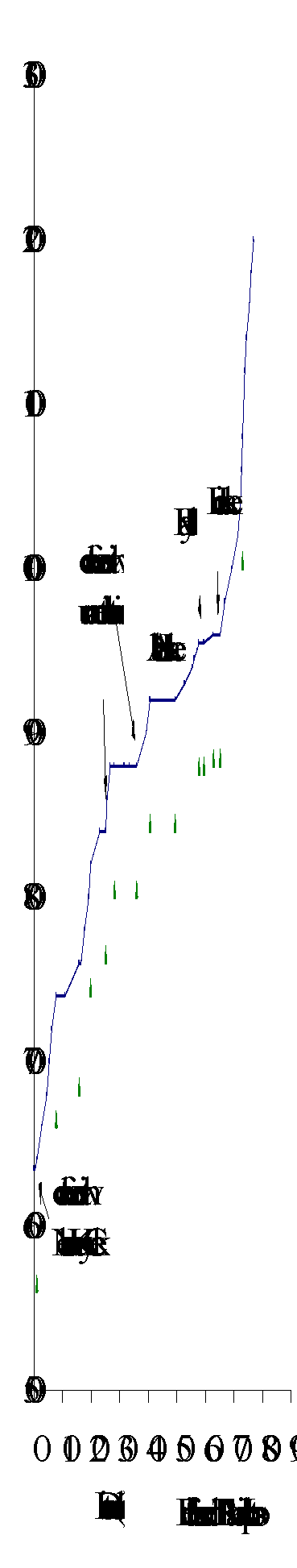
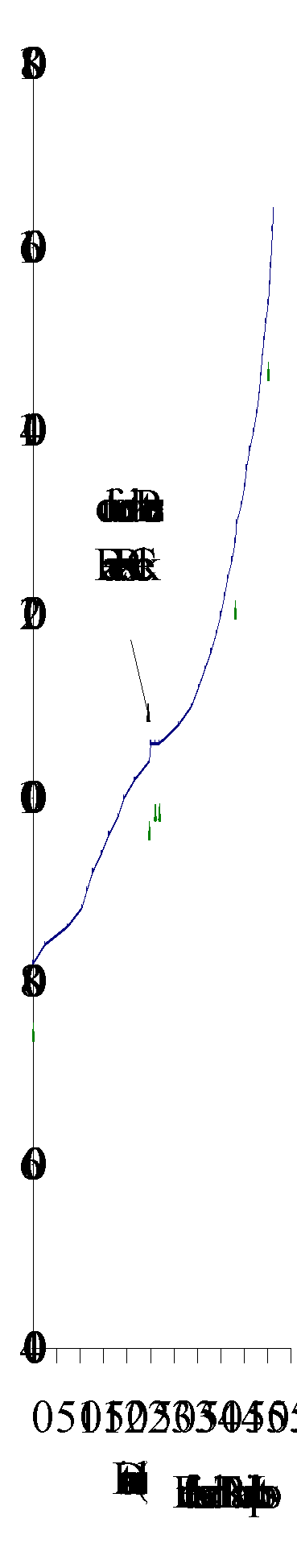
Figure 7. Gradient profile of Ahbau Creek with 15 reaches delineated by triangles.
Ahbau Creek is characterized by a large amount of forest development in the upper reaches with moderate impacts on fish habitat. Private land encompasses 6.0% of the lower reaches of Ahbau Creek (Chapman and Dobson, 1997). The Cottonwood/Swift River IWAP indicated that the ECA for Ahbau Creek was 40% (Dobson, 1996). Based on a highest rating of 1.00, the hazard index for peak flow was 0.37, surface erosion was 0.44, riparian buffer was 0.59 and landslide was 0.27. The moderate riparian buffer hazard rating indicated that numerous stream channels in Ahbau Creek sub-basin were harvested to the stream edge. The other hazard indices were low and indicated no obvious concerns or hazards in the sub-basin. Forest harvesting in Ahbau Creek sub-basin has resulted in riparian area impacts along several tributaries (AIM, 1996; Rowland and McDonald, 1996). Forest harvesting has been concentrated in the area north of Ahbau Lake and along the first unnamed tributary.
Carr et al. (1996) described 142 sediment sources in the sub-basin; 83% were man-made, with 65% associated with forest harvesting and associated roads in their sediment survey. Twenty-two of 91 forestry related sources fall into the high-risk category and are associated with forest access roads (Carr et al., 1996). Most sites are recommended for field assessment where they appear to impact fish habitat, and Carr et al. (1996) has suggested road deactivation and re-vegetation of many sites. They also identified that the natural sediment sources in the Ahbau Creek Sub-basin were associated with stream instability. Carr et al. (1996) did not specify whether this was a function of natural fluvial processes, downstream impact of the seven mine sites or forest development.
Highway 97 passes through reach 1 of Ahbau Creek. Right-of-ways of B.C. Railway, hydro lines and gas pipelines cross reach 4. Agricultural activities in the sub-basin are cattle ranching and irrigation. Chapman and Dobson (1997) stated that some bank erosion and channel disturbance in the lower sub-basin were related to cattle grazing. Placer mining and hard rock exploration has altered the landscape in several areas (Rowland and McDonald, 1996).
Habitat condition and preliminary assessment
Ahbau Creek flows over gently rolling terrain in the lower reaches, while the upper reaches flow from more dissected terrain. The creek meanders within a narrow flood plain formed of glacial drift soils. The Habitat Condition Summary form in Appendix C2 provides a general description of the stream habitat conditions based on available data. Habitat concerns include lack of riparian vegetation, isolated wetlands and road related migration barriers. Table 2 gives a brief summary of the preliminary assessment of environmental impacts, assigned priority for Level 1 assessment and potential restoration opportunities.
Table 2. Preliminary assessment of environmental impacts, priority for Level 1 assessment and restoration opportunities in Ahbau Creek.
|
Sub Basin |
Reach |
Channel |
Channel |
Habitat |
Upslope |
Potential Impacts |
Priority‡ |
Restoration |
|
Name |
Num |
Type* |
Stability† |
Value‡ |
Impact‡ |
Opportunities |
||
|
Ahbau 100-4811-073 |
1 |
RPgw |
S |
H |
M |
The bridged highway that crosses the reach should be assessed for fish habitat impacts. |
M |
Re-vegetation and bioengineering of the river bank to limit impacts on fish habitat, if necessary. |
|
2 |
RPgw |
S |
H |
H |
Logging activity has clearcut to the streamside. Natural slumping of creek banks. Rural developments may have encroached on the riverbank causing slumping of the banks. |
H |
Re-vegetation and bioengineering of the river bank to limit impacts on fish habitat if necessary. Bank stabilisation and re-vegetation of the riverbank, if necessary. |
|
|
4 |
RPgw |
S |
H |
M |
The hydrolines and B.C. railway that cross the reach should be assessed for fish habitat impacts. |
M |
Re-vegetation and bioengineering of the river bank to limit impacts on fish habitat, if necessary. |
|
|
10 |
RPgw |
S |
M |
L |
The road that crosses the creek should be assessed for fish habitat impacts. Logging activity has clearcut to the stream side |
M |
Re-vegetation and bioengineering of the river bank to limit impacts on fish habitat, if necessary. |
|
|
12 |
CPcw |
S |
M |
L |
The road that crosses the creek should be assessed for fish habitat impacts. Logging activity has clearcut to the stream side |
M |
Re-vegetation and bioengineering of the river bank to limit impacts on fish habitat, if necessary. |
|
|
First unnamed tributary |
1 |
RPgw |
S |
H |
M |
Logging activity may have impacted the riparian vegetation. |
H |
Modification of road crossing if found to be a barrier to fish migration, if necessary. |
|
2 |
RPgw |
S |
H |
M |
Historic logging activity may have impacted the riparian vegetation. The road that crosses the creek should be assessed for fish habitat impacts. |
H |
Modification of road crossing if found to be a barrier to fish migration, if necessary. |
|
The following briefly describes areas of concern on Ahbau Creek on a reach basis, based on available information. The bridge for Highway 97 spans reach 1 and has the potential to input sediment into the creek and affect fish habitat. In reach 2 of Ahbau Creek are waterfalls that Rowland and McDonald (1996) described as an obstruction to fish passage in most years. An assessment of the obstruction in reach 2 is recommended. Natural slumping of creek banks is a common occurrence in the Ahbau Creek sub-basin and along the mainstem in reaches 2 through 7. Stream crossings in reach 2 may also be contributing to the slumping and should be assessed for impacts on fish habitat. Reach 4 is spanned by the British Columbia Railway and hydroline right-of-ways that also have the potential to be impacting the fish habitat. According to AIM (1996), some slope failures can be associated with skid roads and cutblocks on gullies and tributaries. Most of the slope failures along the mainstem are associated with natural slumping of the steep riverbanks. The riparian area of Ahbau Creek has been logged in reaches 2, 10 and 12 and on the unnamed tributary. These reaches should be assessed to determine the impacts on fish habitat. Beaver dams are located below Ahbau Lake and may limit fish distribution.
Fish sampling is recommended for both of the unnamed tributaries of Ahbau Creek. The first unnamed tributary of Ahbau Creek is a low-lying marshy creek that flows north into Ahbau Creek. Reach 1 has sections with inadequate riparian vegetation and should be assessed for potential impacts on fish habitat. Reach 2 is transected by a 30-year-old clearcut area that appears to be in an advanced stage of regeneration. The stream crossing in reach 2 of the first unnamed tributary may be a barrier to fish migration and should be assessed. This stream crossing may also be deactivated.
The second unnamed tributary of Ahbau Creek is also a marshy creek, but it flows south into Ahbau Creek. No impacts were observed on this tributary.
Fish habitat restoration opportunities in Ahbau Creek include re-vegetation of the riparian areas, including roads and right-of-ways that cross the creek, and appropriate restoration of any impacted fish habitat on the tributary.
Nelson Kenny Creek (100-4811-073-010) flows southeast to Ahbau Creek, 1 km upstream of the Ahbau Creek and Cottonwood River confluence (Figure 6). The creek has a mainstem length of 14 km with six reaches delineated on the gradient profile (Figure 8). Nelson Kenny Creek drains an area of 7, 923 ha (Dobson, 1996). There are two lakes along the mainstem; Nelson Kenny Lake is located 9.5 km upstream of the Ahbau and Nelson Kenny Creek confluence; and Chubb Lake is located approximately13 km upstream of the Ahbau and Nelson Kenny Creek confluence.
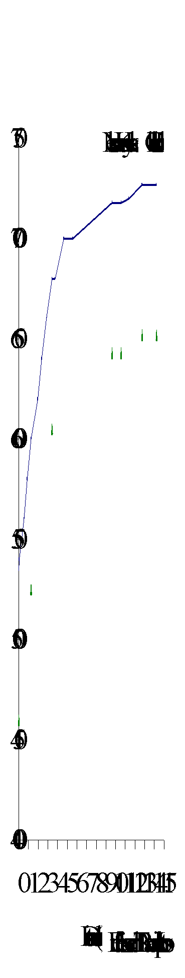
Figure 8. Gradient profile of Nelson Kenny Creek with six reaches delineated by triangles.
According to FISS (1994), chinook salmon use the lower two reaches of Nelson Kenny Creek as spawning and rearing habitat (Appendix B3; Figure 6). There is no indication, based on the gradient profile, of what limits upstream migration, so chinook are suspected of using the habitat in reach 3.
Nelson Kenny Creek is characterized by a moderate amount of forestry and agricultural activity. The Cottonwood/Swift River IWAP indicated that the ECA for Nelson Kenny Creek was 22% (Dobson, 1996). Based on a highest rating of 1.00, the hazard index for peak flow was 0.12, surface erosion was 0.54, riparian buffer was 1.00 and landslides was 0.13. The moderate surface erosion hazard index indicated that inactive roads should be deactivated to restore the natural drainage patterns (Dobson, 1996). The high hazard index for riparian buffer indicated that numerous stream channels in Nelson Kenny sub-basin have been clearcut to the stream edge, from both agricultural and forestry activities. This lack of shading may increase stream temperatures and reduce the input of organic matter, which affect fish populations.
AIM (1996) estimated that about 22% of the Nelson Kenny Creek sub-basin had been logged, while Chapman and Dobson (1997) stated that ECA was 7% for the crown land on the sub-basin. They did not state an ECA for the entire sub-basin. Private land, most of which has been cleared for agriculture, encompasses 82% of the sub-basin. Thus 15% of the ECA for Nelson Kenny Creek sub-basin appears to be private land. Many wetland areas north of Nelson Kenny Lake have inadequate riparian buffers. Clearcut logging has also left inadequate riparian vegetation along several sections of the creek.
Habitat condition and preliminary assessment
Nelson Kenny Creek is characterized by a low gradient with extensive wetlands along the mainstem. The Habitat Condition Summary form in Appendix C3 gives a general description of the stream habitat conditions based on available data. Fish habitat concerns include road related migration barriers in several reaches and lack of overhanging vegetation due to missing riparian vegetation on wetlands and along the creek. Table 3 gives a brief summary of the preliminary assessment of environmental impacts, assigned priority for Level 1 assessment and potential restoration opportunities.
The following briefly describes areas of concern on Nelson Kenny Creek on a reach basis. Reaches 1, 2, 3, 5 and 6 of Nelson Kenny Creek contain roads that cross the creek. These reaches should be assessed as potential migration barriers and for fish habitat impacts. Logging and agricultural activities have left inadequate riparian vegetation in reaches 1, 2, 4 and 5. These reaches should be assessed to quantify fish habitat impacts.
|
Sub Basin |
Reach |
Section |
Channel |
Channel |
Habitat |
Upslope |
Potential Impacts |
Priority‡ |
Restoration |
||||
|
Name |
Num |
Type* |
Stability† |
Value‡ |
Impact‡ |
Opportunities |
|||||||
|
Nelson Kenny Creek 100-4811-073-010 |
1 |
CPgw |
S |
H |
M |
The bridged road that crosses the creek should be assessed for fish habitat impacts. Historical logging activity has clearcut to the streamside. Agricultural activities have also impacted the riparian area |
H |
Re-vegetation and bioengineering of the river bank to limit impacts on fish habitat, if necessary. |
|||||
|
2 |
CPgw |
S |
H |
M |
The road that crosses the creek should be assessed for fish habitat impacts. Historical logging activity has clearcut to the streamside. Agricultural activities have also impacted the riparian area |
H |
Re-vegetation and bioengineering of the river bank to limit impacts on fish habitat, if necessary. |
||||||
|
3 |
RPgw |
S |
L |
M |
The bridged road that crosses the creek should be assessed for fish habitat impacts. |
M |
Re-vegetation and bioengineering of the river bank to limit impacts on fish habitat, if necessary. |
||||||
|
4 |
L |
S |
L |
L |
Logging activity has clearcut to the lakeshore. |
L |
Re-vegetation and bioengineering to limit impacts on fish habitat, if necessary. |
||||||
|
5 |
RPgw |
S |
L |
M |
The road that crosses the creek should be assessed for fish habitat impacts. Logging activity has clearcut to the streamside. |
L |
Re-vegetation and bioengineering of the river bank to limit impacts on fish habitat, if necessary. |
||||||
Restoration opportunities include re-vegetation or bioengineering of the creek to limit impacts of logging on fish habitat and assessment and modification of culverts found to hinder fish migration. Effects of the impacts on fish habitat caused by agricultural related activities include impacts to the riparian areas.
Umiti Creek (100-4811-287) flows from an elevation of 1850 m westward into the Cottonwood River, 43 km upstream of the Cottonwood and Fraser River confluence (Figure 9). The creek has a mainstem length of 31 km with five reaches delineated on the gradient profile (Figure 10). Umiti Creek sub-basin drains an area of 14,876 ha (Dobson, 1996), and contains one unnamed tributary that was assessed for fish and fish habitat concerns.
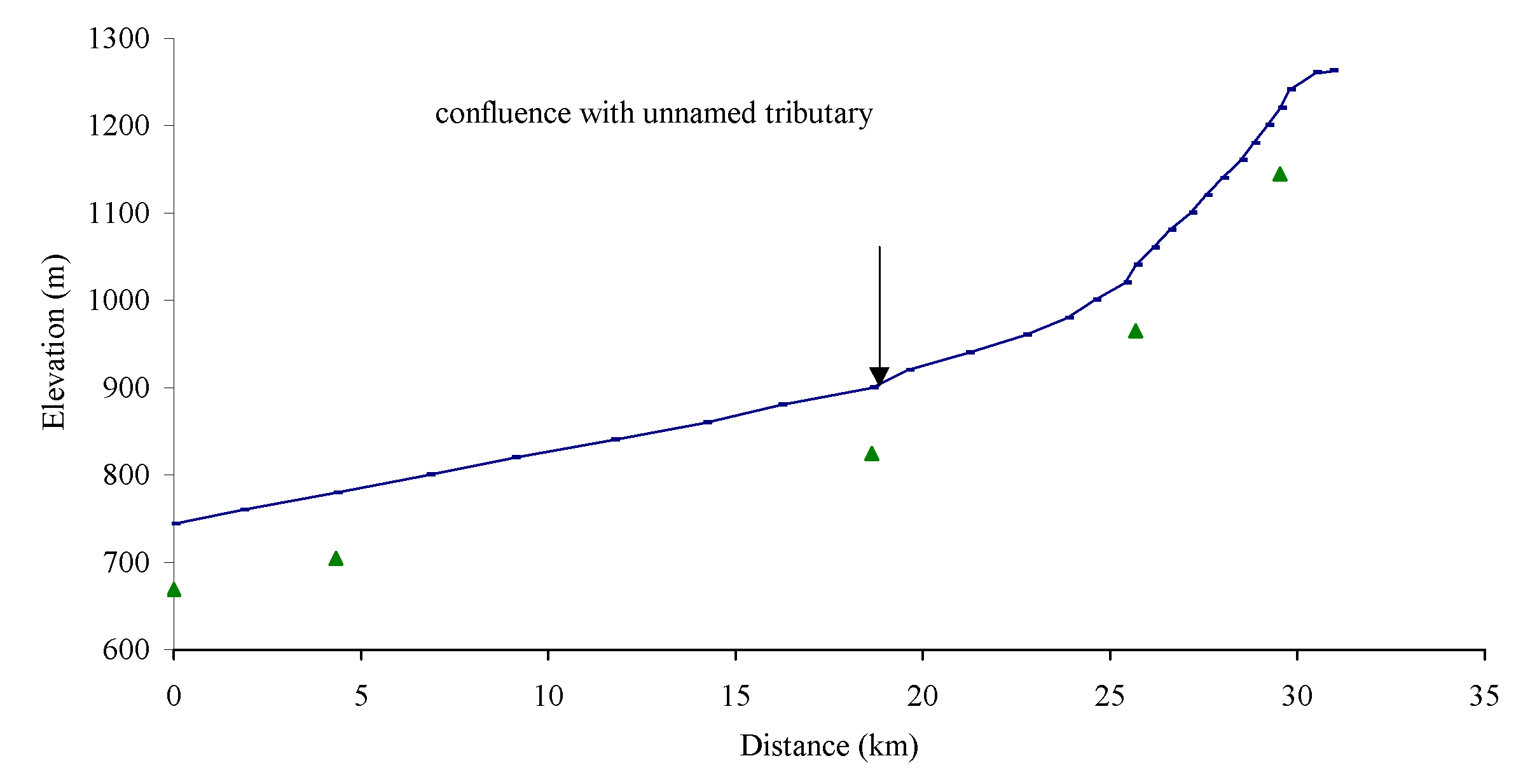
Figure 10. Gradient profile of Umiti Creek with five reaches delineated by triangles.
FISS (1994) does not document the presence of chinook salmon in Umiti Creek, but chinook salmon are suspected of using Umiti Creek as rearing habitat (Fish Habitat Inventory and Information Program, 1990; Appendix B4; Figure 9). A fish inventory is recommended to determine the presence or absence of fish and is scheduled for publication in 1998 (Carmanah, in progress).
Umiti Creek is characterized by a moderate amount of forest development and placer mining activity. The Cottonwood/Swift River IWAP indicated that the ECA for Umiti Creek was 23.3% (Dobson, 1996). Based on a highest rating of 1.00, the hazard index for peak flow was 0.53, surface erosion was 0.51, riparian buffer was 0.69 and landslide was 0.40. Dobson (1996) stated that portions of the stream channels in the Umiti Creek sub-basin were unstable due to forest development and placer mining activity. The moderate surface erosion hazard rating indicated that inactive roads should be deactivated to restore natural drainage patterns. The moderate riparian buffer hazard rating indicated that numerous stream channels in Umiti Creek sub-basin have been harvested to the stream edges. The landslide hazard index was low yet Dobson (1996) stated that the bridge crossing on the 600 Road at 23km requires field assessment. Fish habitat has been affected by the removal of riparian vegetation from several reaches and input of sediment from streamside logging activities (AIM, 1996).
Carr et al. (1996) described 58 sediment sources in the Umiti Creek sub-basin; 78% were man-made with all but one associated with forest development. Eight of 57 forestry related sources fell into the high-risk category and were caused by road development (Carr et al., 1996). Road or block deactivation was recommended to address the forestry-related problem sites.
Habitat condition and preliminary assessment
Umiti Creek is characterized by a low-gradient sinuous stream channel along its entire length. The Habitat Condition Summary form in Appendix C4 gives a general description of the stream habitat conditions. The channel of Umiti Creek is an extensive riffle, pool and bar habitat with some braiding and side channel development. The natural and man-made slumping of the creek bank has the potential to cause channel agraddation and infilling of the fish habitat (Photos 1 and 2). Habitat concerns include roads that cross the creek, inadequate riparian areas and exposed soils close to the creek side. Table 4 gives a brief summary of the preliminary assessment of environmental impacts, assigned priority for Level 1 assessment and restoration opportunities.
The following briefly describes areas of concern on Umiti Creek on a reach basis, based on available data. The road that crosses over Umiti Creek in reach 2 is adjacent to a section of the creek with inadequate riparian vegetation. This cutblock, harvested in the 1980’s, continues into reach 3. Logging activity has left inadequate riparian vegetation along approximately 7 km in reaches 3, 4 and 5 of Umiti Creek and along the length of the unnamed tributary. Access roads in the upper reaches appear to be potential sediment sources. These reaches were left with inadequate buffer zones on both sides and appear to be lacking large organic debris and shading. These upper reaches should be assessed for fish habitat impacts and as potential sediment sources impacting fish habitat.
|
Sub Basin |
Reach |
Channel |
Channel |
Habitat |
Upslope |
Potential Impacts |
Priority‡ |
Restoration |
|
Name |
Num |
Type* |
Stability† |
Value‡ |
Impact‡ |
Opportunities |
||
|
Umiti 100-4811-287 |
1 |
RPgw |
S |
H |
M |
The bridged road that crosses the creek should be assessed for fish habitat impacts |
M |
Re-vegetation and bioengineering of the river bank to limit impacts on fish habitat, if necessary. |
|
2 |
RPgw |
S |
H |
M |
The bridged road that crosses the creek should be assessed for fish habitat impacts. Historic logging activity has clearcut to the streamside. |
H |
Re-vegetation and bioengineering of the river bank to limit impacts on fish habitat, if necessary. Re-vegetation of riparian area. |
|
|
3 |
RPcw |
S |
H |
M |
The bridged road that crosses the creek should be assessed for fish habitat impacts. Historic logging activity has clearcut to the streamside. |
H |
Re-vegetation and bioengineering of the river bank to limit impacts on fish habitat, if necessary. Re-vegetation of riparian area. |
|
|
4 |
RPcw |
S |
H |
M |
The bridged road that crosses the creek should be assessed for fish habitat impacts. Historic logging activity has clearcut to the streamside. |
H |
Re-vegetation and bioengineering of the river bank to limit impacts on fish habitat, if necessary. Re-vegetation of riparian area. |
|
|
5 |
RPcw |
S |
H |
M |
The bridged road that crosses the creek should be assessed for fish habitat impacts. Historic logging activity has clearcut to the streamside. |
H |
Re-vegetation and bioengineering of the river bank to limit impacts on fish habitat, if necessary. Re-vegetation of riparian area. |
|
|
Unnamed trib. |
1 |
CPgw |
S |
H |
H |
The bridged road that crosses the creek should be assessed for fish habitat impacts. Logging activity has clearcut to the streamside along portions of reaches. |
H |
Re-vegetation and bioengineering of the river bank to limit impacts on fish habitat, if necessary. Re-vegetation of riparian area. |
Recommendations
Restoration opportunities on Umiti Creek include bioengineering and re-vegetation of riparian areas.
 John Boyd Creek
(100-4811-308) flows west into Cottonwood River, 45 km upstream of the Cottonwood
and Fraser River confluence (Figure 11). The creek has a mainstem length of
21 km with six reaches delineated on the gradient profile (Figure 12). The John
Boyd Creek sub-basin drains a watershed area of 11,046 ha (Dobson, 1996). There
are three third order tributaries on John Boyd Creek; an unnamed tributary is
located 0.5 km upstream of the John Boyd and Cottonwood confluence; and Alice
Creek is located 11 km upstream of the John Boyd and Cottonwood confluence.
Mary Creek is a tributary of Alice Creek and is located 1 km upstream of the
Alice and John Boyd Creek confluence.
John Boyd Creek
(100-4811-308) flows west into Cottonwood River, 45 km upstream of the Cottonwood
and Fraser River confluence (Figure 11). The creek has a mainstem length of
21 km with six reaches delineated on the gradient profile (Figure 12). The John
Boyd Creek sub-basin drains a watershed area of 11,046 ha (Dobson, 1996). There
are three third order tributaries on John Boyd Creek; an unnamed tributary is
located 0.5 km upstream of the John Boyd and Cottonwood confluence; and Alice
Creek is located 11 km upstream of the John Boyd and Cottonwood confluence.
Mary Creek is a tributary of Alice Creek and is located 1 km upstream of the
Alice and John Boyd Creek confluence.
Figure 12. Gradient profile of John Boyd Creek with six reaches delineated by triangles.
Chinook salmon and rainbow trout are found throughout the creek (Figure 11; FISS, 1994). The lower reaches of the tributaries are suspected to be used for chinook rearing (FISS, 1994; Appendix B5).
John Boyd sub-basin is characterized by a large amount of forest development and mining activity. The combination of development activities has resulted in about 27 km of stream with inadequate riparian vegetation. Vegetation has been re-established, although sparsely in all reaches except a section of reach 4, which has been re-vegetated (pers. comm. L. Chevrette, Carmanah, 1997). Forest harvesting has removed 48% of forest cover from the John Boyd sub-basin (AIM, 1996). The Cottonwood/Swift River IWAP indicated that the ECA for John Boyd Creek was 40% (Dobson, 1996). Based on a highest rating of 1.00, the hazard index for peak flow was 0.88, surface erosion was 0.83, riparian buffer was 1.00 and landslide was 0.09. Dobson (1996) stated that portions of the stream channels in the John Boyd Creek sub-basin were unstable due to forest development and placer mining activity. The high surface-erosion hazard rating indicated that the inactive roads should be deactivated to restore natural drainage patterns. The high riparian buffer hazard rating indicated that numerous stream channels in John Boyd Creek sub-basin have been harvested to the stream edges.
Carr et al. (1996) described 56 sediment sources in the John Boyd Creek sub-basin; 84% were man-made with 73% associated with forest development. Fourteen of 44 forestry related sources fell into the high-risk category and were caused by forest harvesting and access roads. They recommended road or block deactivation to address the forestry-related problem sites. Carr et al. (1996) also identified four sediment sources related to mine developments that had high-risk classifications for sediment generation. Any restoration program that improves fish habitat will need to take into account natural sediment loading and mining impacts.
Habitat conditions and preliminary assessment
John Boyd Creek is characterized by riffle and pool habitat throughout the six reaches. The streambed is composed of gravel and fine sediments and enhanced by woody debris. Habitat Condition Summary form in Appendix C5 gives a general description of the stream habitat conditions. Habitat concerns include aggradation of the creek, lack of riparian buffers along the streamside and roads that cross the creek. Table 5 gives a brief summary of the potential impacts, assigned priority for Level 1 assessment and potential restoration opportunities.
The following briefly describes areas of concern on John Boyd Creek and tributaries on a reach basis, based on available data. The bridge crossings over John Boyd Creek in reaches 1, 4 and 5 should be assessed for potential impacts on fish habitat. The riparian vegetation in reaches 2, 3, 4 and 5 were harvested to the streamside. Although preliminary assessment indicates that most of the riparian areas have regenerated, there may be impacts on fish habitat. In reach 4 there appears to be extra sediment, forming sediment bars, that could have been washed out of Alice Creek.
|
Sub Basin |
Reach |
Channel |
Channel |
Habitat |
Upslope |
Potential Impacts |
Priority‡ |
Restoration |
|
Name |
Num |
Type* |
Stability† |
Value‡ |
Impact‡ |
Opportunities |
||
|
John Boyd Creek 100-4811-308 |
1 |
PRgw |
D |
H |
M |
The road that crosses the reach may be impacting fish habitat. |
M |
Re-construction or modification of the crossing , if necessary |
|
2 |
PRgw |
D |
H |
H |
The riparian area has been clearcut to the streamside. |
H |
Re-vegetation of riparian area, if necessary. |
|
|
3 |
PRgw |
D |
H |
H |
The riparian area has been clearcut to the streamside. |
H |
Re-vegetation of riparian area, if necessary. |
|
|
4 |
PRgw |
D |
H |
H |
The bridged road that crosses the reach may be impacting fish habitat. The riparian area has been clearcut to the streamside. |
H |
Re-construction or modification of the bridge, if necessary. Re-vegetation of riparian area, if necessary. |
|
|
5 |
PRgw |
D |
H |
H |
The riparian area has been clearcut to the streamside. |
H |
Re-vegetation of riparian area, if necessary. |
|
|
6 |
PRgw |
S |
H |
H |
The road that crosses the reach may be impacting fish habitat. |
M |
Re-construction or modification of the crossing , if necessary |
|
|
Unnamed tributary |
2 |
RPgw |
A |
M |
H |
The riparian area has been clearcut to the streamside. |
H |
Re-vegetation of riparian area, if necessary. |
|
3 |
RPgw |
A |
L |
H |
The road that crosses the reach may be impacting fish habitat. The riparian area has been clearcut to the streamside. |
H |
Re-construction or modification of the crossing, if necessary. Re-vegetation of riparian area. |
|
|
4 |
RPgw |
A |
L |
L |
The road that crosses the reach may be impacting fish habitat. |
L |
Re-construction or modification of the crossing, if necessary. |
|
|
Alice Creek 100-4811-308-511 |
1 |
CPcw |
A |
H |
H |
The riparian area has been clearcut to the streamside. |
H |
Re-vegetation of riparian area, if necessary. |
|
2 3 |
CPcw |
A |
H |
H |
The road that crosses the reach may be impacting fish habitat. The riparian area has been clearcut to the streamside. |
H |
Re-construction or modification of the crossing, if necessary. Re-vegetation of riparian area. |
|
|
Mary Creek 100-4811-308-511-079 |
1 2 3 4 5 |
CPcw |
A |
H |
H |
The roads that cross the reach may be impacting fish habitat. The riparian area has been clearcut to the streamside. |
H |
Re-construction or modification of the culvert to allow fish passage if found to be a migration barrier. Re-vegetation of riparian area. |
The unnamed tributary has a stream channel composed of pool and riffle habitat with a gravel bed. Large organic debris enhances the habitat that lacks overhanging vegetation. Reaches 2 and 3 of the unnamed tributary were clearcut to the streamside and should be assessed for fish habitat impacts. The stream crossings in reaches 3 and 4 should be assessed for potential impacts on fish and fish habitat.
Alice Creek is a fast-flowing creek composed of cascades and pools. The creek bed is composed of cobble and larger rocks with some organic debris. Mary Creek, a tributary to Alice Creek, has a similar channel. Both creeks have inadequate riparian vegetation and may contain stream crossings that are barriers to fish migration. Impacts from forest activities in the unnamed tributary, Alice and Mary creeks have been described in Table 5, but fish sampling is recommended before restoration opportunities are undertaken. Chinook salmon are suspected to access reach 1 of all three tributaries (the unnamed tributary, Alice and Mary creeks).
Opportunities for fish habitat restoration include re-vegetation of clearcut riparian areas and modification of culverts that are migration barriers to chinook salmon and rainbow trout. Rowland and McDonald (1996) agreed that John Boyd Creek has a high level of habitat concerns.
 Lightning
Creek (100-481-389) flows from an elevation of 1640 m west to the Cottonwood
River, 61.7 km upstream of the Cottonwood and Fraser River confluence (Figure
13). Lightning Creek has a mainstem length of 50 km with six reaches delineated
on the gradient profile (Figure 14). It drains a watershed area of 24,940 ha
(Dobson, 1996). Peters and Beaver Pass creeks are third order tributaries of
Lightning Creek. They both flow into Lightning Creek approximately 27 km upstream
of the Lightning Creek and Swift River confluence. The Water Survey of Canada
guaging station 08KE004, located at Wingdam, documented the mean annual water
flow at approximately 5.0 m3 s-1 (Rowland and McDonald,
1996). Seasonal low water flows in the wintertime were 0.67 m3 s-1
and in the summertime were 1.32 m3s-1.
Lightning
Creek (100-481-389) flows from an elevation of 1640 m west to the Cottonwood
River, 61.7 km upstream of the Cottonwood and Fraser River confluence (Figure
13). Lightning Creek has a mainstem length of 50 km with six reaches delineated
on the gradient profile (Figure 14). It drains a watershed area of 24,940 ha
(Dobson, 1996). Peters and Beaver Pass creeks are third order tributaries of
Lightning Creek. They both flow into Lightning Creek approximately 27 km upstream
of the Lightning Creek and Swift River confluence. The Water Survey of Canada
guaging station 08KE004, located at Wingdam, documented the mean annual water
flow at approximately 5.0 m3 s-1 (Rowland and McDonald,
1996). Seasonal low water flows in the wintertime were 0.67 m3 s-1
and in the summertime were 1.32 m3s-1.
Figure 14. Gradient profile of Lightning Creek with six reaches delineated by triangles.
According to FISS (1994) and Imhof and Sutherland (1996), chinook salmon and rainbow trout are found throughout Lightning Creek (Appendix B6; Figure 13). Chinook spawn throughout the creek in August and September. Bull trout also reside in the creek. Fish production is limited by poor gravel quality due to siltation and low water flow which causes access problems (Imhof and Sutherland, 1996). Imhof and Sutherland (1996) found rainbow trout in Peters Creek, but only longnose suckers (Catostomus catostomus) were found in Beaver Pass Creek.
Second-order tributaries, outside the scope of this Overview, are reported to contain waterfalls as possible migration barriers, and road- related migration barriers (Imhof and Sutherland, 1996). Imhof and Sutherland (1996) described the fish distribution in the smaller tributaries that is summarized in Appendix B6.
Lightning Creek is characterized by significant amounts of forestry, mining and linear developments. The Cottonwood/Swift River IWAP indicated that the ECA for Lightning Creek was 15.6% (Dobson, 1996). Based on a highest rating of 1.00, the hazard index for peak flow was 0.50, surface erosion was 0.68, riparian buffer was 0.49 and landslide was 0.31. Dobson (1996) stated that portions of the stream channels in the Lightning Creek sub-basin were unstable due primarily to placer mining activity and secondarily to forest development. The moderate surface erosion hazard rating indicated that inactive roads should be deactivated to restore natural drainage patterns. The moderate riparian buffer hazard rating indicated that numerous stream channels in Lightning Creek sub-basin have been harvested to the stream edges.
Carr et al. (1996) described 165 sediment sources in the Lightning Creek sub-basin; 73% were man-made with 44% associated with forest development. Twenty-three of 73 forestry-related sources fell into the high-risk category and were caused by harvesting and access roads (Carr et al., 1996). Carr et al. (1996) recommended road or block deactivation to address the forestry-related problem sites. They also identified 21 of 23 mine developments that have high-risk classifications for sediment generation. Any restoration program that improves fish habitat will need to take into account natural sediment loading and mining impacts. Riverbank failures are a common source of sediment into Lightning Creek. Most slope failures that have occurred along the mainstem of the creek are due to inadequate riparian vegetation or roads. Poor leave strips in Peters Creek have introduced sediment into Lightning Creek (Rowland and McDonald, 1996). Some sediment input can also be associated with natural slumping of the riverbanks.
Extensive placer mine activity has occurred in the sub-basin, resulting in siltation of the creek bed and removal of streamside vegetation (Rowland and McDonald, 1996; Chapman and Dobson, 1997). The loss of riparian vegetation limits spawning and rearing habitats. Burns Mountain Gold mine and an intermittently operating underground placer mine have affected water quality on Lightning Creek near Wingdam.
Access into Lightning Creek sub-basin is from Highway 26 that parallels Lightning Creek for approximately 40 km, along reaches 1 through 4. Placer mining and logging roads are also found throughout the sub-basin. The highway also provides access to Troll Mountain Ski Hill, which has caused erosion and siltation of Lightning Creek in reach 2 (FISS, 1994; Chapman and Dobson, 1997).
Habitat condition and preliminary assessment
Lightning Creek has a low-gradient sinuous channel with wetland floodplains along the mainstem. There are several bank failures along the lower reaches. The lowest reaches meander extensively within the flood plain before merging with the Swift River. The Habitat Condition Summary form in Appendix C6 gives a general description of the stream habitat conditions. Habitat concerns include inadequate riparian vegetation along wetlands and stream sides and increased sediment input from road crossings and the highway that parallels the creek. Table 6 gives a brief summary of the potential impacts, potential restoration opportunities and the assigned priority for Level 1 assessment.
|
Sub Basin |
Reach |
Channel |
Channel |
Habitat |
Upslope |
Potential Impacts |
Priority‡ |
Restoration |
|
Name |
Num |
Type* |
Stability† |
Value‡ |
Impact‡ |
Opportunities |
||
|
Lightning 100-4811-389 |
1 2 3 4 |
RPgw |
D |
H |
H |
The roads that cross and parallel the reach may be causing limitations to fish habitat. |
H |
Re-construction or modification of the roads and crossing, if necessary. |
|
5 |
RPcw |
D |
H |
H |
The riparian area has been clearcut to the streamside. |
H |
Re-vegetation of riparian area, if necessary. |
|
|
Peters 100-4811-389-484 |
1 |
RPgw |
S |
H |
L |
The road that crosses the reach may be a barrier to fish migration or impact fish habitat. |
M |
Re-construction or modification of the culvert to allow fish passage if found to be a migration barrier |
|
2 |
RPgw |
S |
H |
L |
The road that crosses the reach may be a potential barrier to fish migration. The riparian area has been clearcut to the streamside. |
H |
Re-construction or modification of the culvert to allow fish passage if found to be a migration barrier. Re-vegetation of riparian area. |
|
|
Beaver Pass 100-4811-389-496 |
1 |
RPgw |
S |
H |
L |
The road that crosses the reach may be a barrier to fish migration. |
M |
Re-construction or modification of the culvert to allow fish passage if found to be a migration barrier |
|
2 |
RPgw |
S |
H |
L |
The riparian area has been harvested to the streamside. |
H |
Re-vegetation of riparian area, if necessary. |
|
|
3 |
RPgw |
S |
H |
L |
The riparian area has been clearcut to the streamside. |
H |
Re-vegetation of riparian area, if necessary. |
|
The following briefly describes areas of concern along Lightning Creek on a reach basis, based on available data. On Lightning Creek, reaches 1 through 4 are impacted by Highway 26 that parallels the creek and by roads that cross the creek. A level 1 assessment is recommended to determine the extent of the impacts on fish habitat. Potential habitat concerns include increased sediment input, poor side channel development due to channel aggradation and inadequate riparian vegetation. Development of farmland in reach 1, near the confluence with the Cottonwood River, has resulted in clearing of riparian vegetation from the streambanks. The bridge and a settling pond for a placer mine site also affected the riparian zone. The steep banks along the creek also are prone to sediment input. Imhof and Sutherland (1996) described fish habitat in reach 1 as containing high percentages of riffles and runs with few pools. The fish habitat was composed of 15-20% cover formed from mainly large organic debris. Other habitats found in reach 1 include deep pools, boulders, overhanging vegetation and cutbanks (Imhof and Sutherland, 1996). The creek bed changes slightly from a high composition of fines and gravel in the lower area of the creek to a high percentage of larger cobble in the upper area (Imhof and Sutherland, 1996).
Reaches 2 and 3 are composed of sinuous pool and riffle habitats as Lightning Creek meanders through the flood plain. Reach 2 has placer mining activity on both sides of the river. There are also three bridges that cross Lightning Creek in this reach. The reach should be assessed for sediment generation from bridge crossings, the highway and mining activity. Reaches 4 and 5 are formed from equal ratios of pools, riffles and runs that have 20% cover (Imhof and Sutherland, 1996). The fish habitats are provided mainly by over-hanging vegetation with some undercut banks, large organic debris and deep pools. Sections of reach 5 of Lightning Creek were harvested to the streambank and should be assessed to quantify habitat concerns.
The channel of Peters Creek was composed of pools, riffles and runs, and, according to Imhof and Sutherland (1996), pools made up 5% of the channel. The stream crossing of Peters Creek should be assessed as a potential migration barrier and sediment source. The culvert could be re-installed or modified to allow fish passage, if found to be migration barrier. In reach 1 the stream is left with an adequate riparian area. Peters Creek had little organic debris in reach 2 to provide secure shelter, but had areas of overhanging vegetation, cutbanks and deep pools (Imhof and Sutherland, 1996).
The channel of Beaver Pass Creek had a similar channel type throughout (Imhof and Sutherland, 1996). The upper reaches meander through a flood plain, while the lower reaches incise the plateau. Several bank failures exist. Several beaver dams in the main channel of Beaver Pass Creek create potential problems during low flow. Reach 1 of Beaver Pass Creek contains a road crossing that should be assessed as a potential barrier and for sediment input. Erosion protection (i.e. rip-rapping) has occurred along the creek where it parallels reach 1. Logging activity has removed the vegetation from reaches 2 and 3. Fish species presence should be established and habitat impacts determined.
Potential restoration opportunities on Lightning Creek and tributaries include potential riparian stabilization, channel stabilization, reclamation of placer mine sites and modify of stream crossings to allow fish passage.
The Swift River (100-4811) flows west to become the Cottonwood River when it meets Lightning Creek, 58 km upstream of Cottonwood and Fraser River confluence (Figure 15). The mainstem of Swift River has a length of 55 km and contains 12 reaches, delineated in the gradient profile (Figure 16). It drains a sub-basin area of 36,277 ha (Dobson, 1996). The entire sub-basin is 113,918 ha if all tributaries are included (Chapman and Dobson, 1997).
The third-order tributaries of Swift River are an unnamed tributary (100-4811–426), Sovereign, Victoria, Bendixon, Porter and Reddish creeks and Little Swift River. The unnamed tributary (100-4811–426), Bendixon and Porter creeks are discussed in this section; the rest are described as separate sub-basins. The unnamed tributary (100-4811-426) flows north into the Swift River, 5 km from the Swift River and Lightning Creek confluence. The unnamed tributary has a mainstem length of 8 km. Bendixon Creek has a mainstem length of 11.8 km and flows south into the Swift River 33 km upstream of the Cottonwood River. Porter Creek has a mainstem length of 13.8 km and flows north into the Swift River 48 km upstream of the Cottonwood River.
According to FISS (1994), chinook salmon spawn in the main
channel of the Swift River from mid-August to mid-September. The Fish Habitat
Inventory and Information System report (1990) described waterfalls on the Swift
River, 23 km upstream from the confluence with Cottonwood River, that are a
migration obstruction for chinook and coho salmon. Rainbow and bull trout, mountain
whitefish (Prosopium williamsoni) and suckers (Catostomus
sp.) are also found in the river. The unnamed tributary of Swift River (100-4811-426)
contains chinook salmon, mountain whitefish and longnose dace (Rhinichthys
cataractae). Imhof and Sutherland (1996) caught rainbow and bull trout in
Bendixon Creek, and captured rainbow trout in Porter Creek (Appendix B7). Figure
15 represents the fish distribution for the Swift River. A fish inventory assessment
conducted on the  Swift River
in 1997 is scheduled for publication in 1998 (Carmanah, in progress).
Swift River
in 1997 is scheduled for publication in 1998 (Carmanah, in progress).
The Cottonwood/Swift River IWAP indicated that the ECA for the Swift River was 20.8% (Dobson, 1996). Based on a highest rating of 1.00, the hazard indices were peak flow 0.36, surface erosion 0.36, riparian buffer 0.80 and mass wasting 0.10. Dobson (1996) stated that portions of the stream channels in the Swift River sub-basin did not have high percentages of erodible soils. This accounts for the low peak flow, surface erosion and mass wasting hazard ratings. The high riparian buffer hazard rating indicated that numerous stream channels in Swift River sub-basin have been harvested to the stream edges. Forest harvesting has removed 27% of the forest cover from Swift River sub-basin (AIM, 1996). Logging activity has removed the riparian vegetation from several reaches.
Carr et al. (1996) described 100 sediment sources in the Swift River sub-basin; 66% were man-made with 65% associated with forest development. Fifteen of 65 forestry-related sources fell into the high-risk category and were caused by forest harvesting and access roads (Carr et al., 1996). Carr et al. (1996) recommended road or block deactivation to address the forestry-related problem sites. They also identified two sediment sources related to mining and agriculture developments that have high-risk classifications for sediment generation. There were 22 unstable natural slopes and gullies identified in the report. Any restoration program that improves fish habitat will need to take into account natural sediment loading and mining impacts.
Habitat condition and preliminary assessment
The channel of Swift River meanders and braids through back channels and small bars. The Habitat Condition Summary form in Appendix C7 gives a general description of the stream habitat conditions. Habitat concerns include clear cutting of the riparian area along several reaches, roads that cross the tributaries and sediment input from roads. Table 7 gives a brief summary of the preliminary assessment of environmental impacts in each stream, the assigned priority for Level 1 assessment and potential restoration opportunities.
Table 7. Preliminary assessment of environmental impacts, priority for Level 1 assessment and restoration opportunities in the Swift River
|
Sub Basin |
Reach |
Channel |
Channel |
Habitat |
Upslope |
Potential Impacts |
Priority‡ |
Restoration |
|
|
Name |
Num |
Type* |
Stability† |
Value‡ |
Impact‡ |
Opportunities |
|||
|
Swift 100-4811 |
1 |
RPgw |
S |
H |
M |
Agricultural and mining impacts have removed portions of the riparian area from the streamside. Natural slumping of riverbank. |
H |
Re-vegetation of riparian area and bank stabilisation, if necessary. |
|
|
3 |
RPgw |
S |
H |
M |
Historical forestry, agricultural and mining impacts have removed portions of the riparian area from the streamside. Natural slumping of riverbank. |
H |
Re-vegetation of riparian area and bank stabilisation, if necessary. |
||
|
6 |
RPgw |
S |
H |
M |
Agricultural impacts have removed portions of the riparian area from the streamside. Natural slumping of riverbank. |
H |
Re-vegetation of riparian area and bank stabilisation, if necessary. |
||
|
8 |
RPgw |
S |
H |
M |
The riparian area has been clearcut to the streamside. |
H |
Re-vegetation of riparian area, if necessary. |
||
|
9 |
RPgw |
S |
H |
M |
The riparian area has been clearcut to the streamside. |
H |
Re-vegetation of riparian area, if necessary. |
||
|
Unnamed tributary 100-4811-426 |
1 |
RPgw |
S |
H |
M |
Historical streamside harvesting has impacted the riparian buffer. |
H |
Re-vegetation of riparian area, if necessary. |
|
|
2 |
RPgw |
S |
H |
M |
The road that crosses the reach may be a potential barrier to fish migration. Historical streamside harvesting has impacted the riparian buffer. |
H |
Re-construction or modification of the culvert to allow fish passage if found to be a migration barrier. Re-vegetation of riparian area, if necessary |
||
|
4 |
RPgw |
S |
H |
M |
Historical streamside harvesting has impacted the riparian buffer. |
H |
Re-vegetation of riparian area, if necessary |
||
|
6 |
RPgw |
S |
H |
M |
The road that crosses the reach may be a potential barrier to fish migration. Historical streamside harvesting has impacted the riparian buffer. |
H |
Re-construction or modification of the culvert to allow fish passage if found to be a migration barrier. Re-vegetation of riparian area, if necessary |
||
|
7 |
RPgw |
S |
H |
M |
Historical streamside harvesting has impacted the riparian buffer. |
H |
Re-vegetation of riparian area, if necessary. |
||
|
Bendixon 100-4811-605 |
1 |
RPgw |
S |
H |
M |
The bridge road that crosses the reach may be impacting the fish habitat. The riparian area has been historically clear-cut to the streamside. |
H |
Re-construction or modification of the crossing, if necessary. |
|
The following briefly describes areas of concern on the Swift River on a reach basis, based on available data. In the lower reaches of the Swift River, the creek bed consists of pools and riffles that are enhanced by large woody debris and boulders (Imhof and Sutherland, 1996). The waterfall at the end of reach 7 marks a change in the channel topography. The river channel in reaches 8 and 9 is composed of riffles and runs with few pools. Imhof and Sutherland (1996) explained that boulders provided fish habitat cover. Portions of reaches 1, 3, 6, 8 and 9 of Swift River have been harvested to the streamside. These reaches should be assessed to quantify habitat impacts.
The unnamed tributary (100-4811-426) has a channel characteristic of a stream that flows slowly through wetlands. The pools and riffles in the tributary are lined with gravel and some woody debris. The stream crossings in reaches 2 and 6 of the unnamed tributary should be assessed for impacts on fish habitat. Harvesting during the 1970‘s and 1980’s has left inadequate riparian vegetation along reaches 1, 2, 4, 6 and 7 of the unnamed tributary (100-4811-426). The exposed streambanks appear to be slumping.
The channel of Bendixon Creek is composed mostly of fine gravel with a few boulders (Imhof and Sutherland, 1996). Instream vegetation provides cover for rearing habitat that is correspondingly enhanced by large organic debris, pools, overhanging vegetation and cutbanks. In reach 1, forest harvesting has removed a section of the riparian vegetation; this area should be assessed to evaluate habitat impacts. An old growth riparian buffer along the channel bank in reach 3 was maintained at the time of harvesting, resulting in low impacts to fish habitat. The upslope areas were harvested in the 1960’s.
Porter Creek flows in a riffle and run channel formed by cobble and gravel in reaches 1 through 3. Imhof and Sutherland (1996) stated that the fish habitat was enhanced by large organic debris, cutbanks and, in some areas, overhanging vegetation. Reaches 4 and 5 are formed by pool and riffle habitat and have a bed of gravel with some larger cobble. Cover for fish species is provided by deep pools, large organic debris and overhanging cutbanks. There are no apparent impacts on Porter Creek.
The size and the rate of water flow in the Swift River limit restoration opportunities. Restoration that focuses on riparian area enhancement and off-channel habitat will provide the most suitable and practical opportunities.
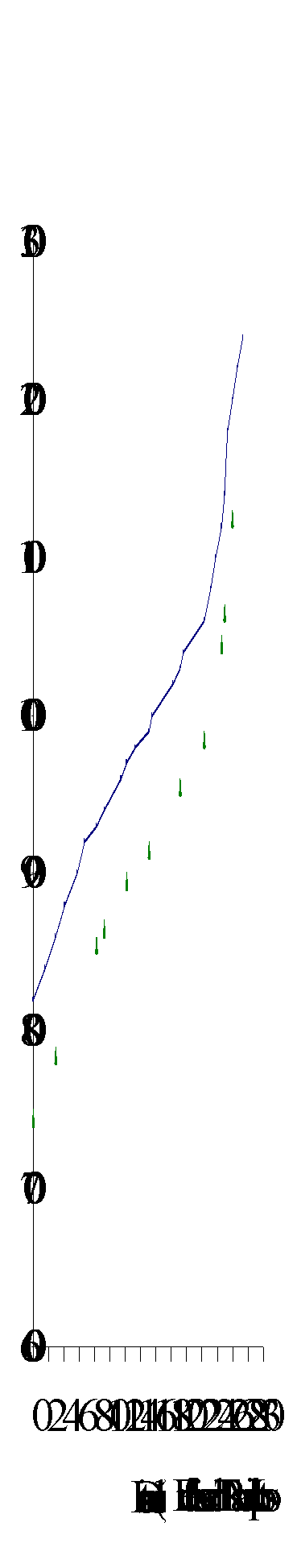 Sovereign
Creek (100-4811-434) flows west into the Swift River, 7 km upstream of the Swift
River and Lightning Creek confluence. It has a mainstem length of approximately
27km with eleven reaches delineated in the gradient profile (Figure 17). The
profile is based on reach breaks provided by the reconnaissance fish inventory
of Sovereign Creek (Carmanah, 1996b). The elevation ranges from 820 m at the
Swift River confluence to 1200 m in its headwaters. Sovereign Creek lies within
a glacial valley in the Cariboo Plateau, and drains an area of 11,249 ha (Dobson,
1996).
Sovereign
Creek (100-4811-434) flows west into the Swift River, 7 km upstream of the Swift
River and Lightning Creek confluence. It has a mainstem length of approximately
27km with eleven reaches delineated in the gradient profile (Figure 17). The
profile is based on reach breaks provided by the reconnaissance fish inventory
of Sovereign Creek (Carmanah, 1996b). The elevation ranges from 820 m at the
Swift River confluence to 1200 m in its headwaters. Sovereign Creek lies within
a glacial valley in the Cariboo Plateau, and drains an area of 11,249 ha (Dobson,
1996).
Figure 18. Gradient profile of Sovereign Creek with eleven reaches delineated by triangles.
Chinook salmon and rainbow trout are present in Sovereign Creek and its tributaries (FISS, 1994; Carmanah, 1996b; Appendix B8, Figure 17). Other non-game species known to exist in the watershed include lake chub (Mylocheilus sp.) and longnose suckers (Catostomus catostomus). FISS (1994) documents chinook salmon only in the lower part of Sovereign Creek, while Carmanah (1996) found chinook up to reach 3 with expected presence into reach 4. As juvenile chinook were also found, it is likely that the lower four reaches of Sovereign Creek are used as rearing habitat. Juvenile chinook were found in Chipp Creek (100-4811-434-107) and an unnamed tributary 100-4811-434-358. Based on this information and the distance juveniles would need to migrate from the nearest known spawning beds in the Swift River, it is likely that chinook spawn in reaches 1 through 4 of Sovereign Creek. Actual chinook spawning beds have not been confirmed in this watershed. Chinook rear in most of the accessible tributaries and any back and side channel habitats.
Rainbow trout reside throughout Sovereign Creek. Rainbow trout are also confirmed in the upper reaches of second order tributaries Lake, Chipp, Moustique, Atis and Eskridge creeks (Carmanah, 1996b). Most of the smaller tributaries also contain rainbow trout, however they are usually confined to lower reaches that are accessible from the Sovereign Creek mainstem.
The Cottonwood/Swift River IWAP indicated that the ECA for Sovereign Creek sub-basin is 35.9% (Dobson, 1996). The hazard ratings for this sub-basin are all rated as high. Based on a highest rating of 1.00, the hazard rating for peak flow was 0.86, surface erosion was 0.61 and riparian buffer was 1.00. The very high hazard rating for the riparian buffer reflects the degree of harvesting along streams in this watershed. This was calculated at 0.39km of harvested stream per square km (Dobson, 1996). The landslide hazard was low, as there were only two slope failures in the sub-basin. Road densities in this sub-basin are high, at 1.02 km/km2 (Dobson, 1996).
The Cottonwood Sediment Source Survey indicated that there were 73 sediment sources in the sub-basin; 67% are man-made with 59% associated with forest development. Thirty-seven of 43 of the forestry related sources fall in the low to moderate risk classification for sediment generation, and individually do not appear to be significantly impacting water quality (Carr et al., 1996). This report also identifies five high to extremely high-risk sediment source sites associated with mine development. These sites are situated along reach 2 of the Sovereign Creek mainstem.
AIM (1996) noted that "habitat alterations along the lower 8.7 km of Sovereign Creek has resulted in high priority ratings." There were four major areas in the sub-basin that were rated as having high to very high habitat impacts related to streamside harvesting of riparian buffers. The primary concern was in reaches 1 and 2 of the Sovereign Creek mainstem (AIM, 1996). No exact estimates were available for the number of active stream crossings. However, preliminary estimates based on Watershed Restoration Planning maps and Aquatic Biophysical maps show there to be over 38 separate fish bearing stream crossings in the sub-basin.
Habitat condition and preliminary assessment
Sovereign Creek is characterized by a low gradient and meandering stream channel. The Habitat Condition Summary Form in Appendix C8 gives a general description of the stream habitat conditions. Habitat concerns include clear cutting of the riparian area along several reaches, stream crossings for the mainstem and tributaries and sediment input from roads and placer mining activities along the streambanks. Table 8 gives a brief summary of the preliminary assessment of environmental impacts, assigned priority for Level 1 assessment and potential restoration opportunities.
Table 8. Preliminary assessment of environmental impacts, priority for Level 1 assessment and restoration opportunities in Sovereign Creek.
|
Sub Basin |
Reach |
Section |
Channel |
Channel |
Habitat |
Upslope |
Potential Impacts |
Priority‡ |
Restoration |
|
Name |
Num |
Type* |
Stability† |
Value‡ |
Impact‡ |
Opportunities |
|||
|
Sovereign Creek 100-4811-434 |
1 |
RPgw |
A |
M |
H |
Historical stream side harvesting, loss of riparian buffer, channel aggradation |
H |
Rehabilitation of fish habitat and re-vegetation of the riparian buffer, if necessary. |
|
|
2 |
RPgw |
A |
M |
H |
Historic stream side harvesting, loss of riparian buffer, channel aggradation and mining development |
H |
Rehabilitation of fish habitat and re-vegetation of the riparian buffer, if necessary. |
||
|
3 |
RPgw |
A |
M |
H |
Historic stream side harvesting, loss of riparian buffer, channel aggradation |
H |
Rehabilitation of fish habitat and re-vegetation of the riparian buffer, if necessary. |
||
|
4 |
B |
A |
M |
H |
Channel aggradation |
H |
Fish habitat rehabilitation, if necessary. |
||
|
5 |
RPgw |
S |
H |
M |
Old Mill Site adjacent road, channel aggradation |
H |
Fish habitat rehabilitation and bank stabilization, if necessary. |
||
|
8 |
L |
S |
M |
M |
Historic cutblock has been clearcut to streambank causing loss of wetland riparian buffer. |
L |
Rehabilitation of fish habitat and re-vegetation of the riparian buffer, if necessary. |
||
|
9 |
CPb |
S |
M |
M |
Historic cutblock has been clearcut to streambank causing loss of wetland riparian buffer. |
L |
Rehabilitation of fish habitat and re-vegetation of the riparian buffer, if necessary. |
||
|
Chipp Creek 100-4811-434-315 |
1 |
RPcw |
U |
M/H |
H |
Historic cutblock has been clearcut to streambank causing loss of wetland riparian buffer. |
L |
Rehabilitation of fish habitat and re-vegetation of the riparian buffer, if necessary. |
|
|
Atis Creek 100-4811-434-599 |
Upslope development activity |
L |
|||||||
|
Eskridge Creek 100-4811-434-610 |
1 |
Mining development |
M |
Sediment control and bioengineering |
|||||
|
2 |
Cutblock has been clearcut to streambank causing loss of wetland riparian buffer. |
L |
Rehabilitation of fish habitat and re-vegetation of the riparian buffer, if necessary. |
||||||
|
Unnamed tributary |
1 |
Mining development |
M |
Sediment control and bioengineering |
|||||
The following briefly decries the habitat conditions in Sovereign Creek, based on available data. Reach 1 of Sovereign Creek is approximately 2.9 km long and contains a pool riffle habitat. The reach was harvested to the streambank in the early 1980’s. Riparian buffers were heavily impacted and channel disturbance indicators such as point and mid-channel bars, channel braiding and eroding banks are evident. There is very little large woody debris in this reach. Carmanah (1996b) reported that the pool frequency and cutbank habitats were fair. Habitat limitations in this reach would most likely be associated with the channel aggradation combined with the noticeable lack of large woody debris. Habitat for rearing, shelter, holding and over wintering in this reach may be factors limiting fish production.
The lower 300 m of this reach from just above the 13A road crossing to the Swift River confluence is canyonized. This confinement forms the channel into a glide riffle complex before it empties into the Swift River. There is no large woody debris noticeable in this section of the reach. Two roads parallel the stream channel in this section where bank erosion is expected to be significant. The upper end of the reach begins to enter steep flood plain terrace slopes on the southern side of the channel valley wall. The steep flood plain banks that were logged provide a direct sediment input into the channel. Dobson (1996) identified one major bank failure associated with this section.
Reach 2 is morphologically the same as reach 1, with mainly riffle pool habitat types. Side channel habitat in this 5.3 km reach is fair, as there are a number of isolated side channels. Riparian buffers are heavily impacted and channel disturbance indicators such as point and mid-channel bars, channel braiding and eroding banks are evident throughout the reach. Large woody debris is scarce and is distributed throughout the channel in clumps. This reach has steep flood plain slopes on the south bank that terminate at the channel in several places. Air photo shadowing makes it difficult to establish slope failures that are effecting the creek. Aerial reconnaissance established several small slope failures that supply sediment to the channel (Photo 2).
The following briefly describes areas of concern on Sovereign Creek on a reach basis. The flood plains along this reach are heavily impacted by placer mining. Several open site mines are located adjacent to the channel and settling ponds on the flood plain are intermittent along the entire reach. The mining activity and its associated access network are likely to be sediment sources that directly impact the stream channel. Dobson (1996) identified road tracks that cross the creek in several sections. This claim will need to be substantiated during Level 1 assessments.
Chipp Creek (100-4811-434-315) marks the upper limit of reach 2 of Sovereign Creek. Chipp Creek is chinook salmon habitat. A riparian buffer of deciduous trees borders the lower 1.5 km of Chipp Creek. This buffer separates it from the cutblock harvested from 1981 to 1982. The effects of logging activity on chinook rearing habitat in Chipp and Sovereign creeks are uncertain and should be quantified in the field. Habitat limitations in reach 2 would most likely be associated with the loss of riparian buffer and mining development activity. Pool and side channel habitat for rearing, shelter and over wintering may be factors limiting fish production. Potential restoration opportunities include side channel access, large organic debris placement and possibly historic settling pond development as backwater rearing habitats. At the 2600 m mark of reach 2 a recently isolated oxbow side channel is evident (Site 1, Carmanah, 1996b). The channel of the creek appears to cross the oxbow but this may have been relocated for mining purposes. The oxbow channel may provide an opportunity to develop chinook rearing habitat and should be investigated during field assessments.
Reach 3 is 1.1 km in length and is a continuation of the channel morphology in reach 2 that is characterized by pool riffle habitat. Reach 3 is bordered by a cutblock harvested from 1983 to 1984 that has been harvested to the streambank on the southern side. Signs of channel disturbance in this reach include extensive areas of un-vegetated bars and sediment wedges. Bank erosion is also evident. The north side of the reach is forested with a mature coniferous riparian buffer. Large organic debris in this reach is lacking (Carmanah, 1996b). There are off channel habitats accessible to fish in this reach. Tributary 100-4811-434-358 borders the upper end of reach 3 and is used by chinook as rearing habitat (Carmanah, 1996b). Tributary 100-4811-434-358 has several logged areas in its upper reaches. The lower reach of this tributary has not been logged. Chinook habitat may be impacted by the forest harvesting along this tributary and should be quantified in the field.
Although chinook have not been identified in Reach 4 or its tributaries, the fact that chinook have been found rearing in a tributary bordering the lower end of the reach indicates that chinook are most likely spawning in this reach. Moustique Creek enters Sovereign Creek mid-way up this reach. Reach 4 has been broken into two sections based on adjacent levels of impact. Section A, the downstream 1.6 km section of the reach, flows through mature coniferous riparian forest. The channel type is riffle pool and follows a meandering route. This section is morphologically similar to reaches 1 and 2 and represents what these reaches may have looked like before streamside development (Carmanah, 1996b). Several access roads to the stream channel were noted at the upper end of the section that may be potential sediment sources. Channel disturbance indicators include extensive sediment wedges and channel braiding.
Section B, the upper section, is 1.2 km in length and adjacent to both mining and forestry related activity. Forest cover data indicate that logging occurred in the early 1960’s, with regeneration at age class 2 (21-40 years). Channel disturbance indicators for this section are channel braiding, isolated side channels and sediment wedges. At the 900 m mark of this section the channel appears to have cut across a point bar, isolating a meander bend and creating an oxbow like side channel (Site 2, Carmanah, 1996b). Once substantiated in the field, this may provide a possible rehabilitation option for side channel rearing habitat.
Tributary 100-4811-434-475 enters on the south side of the reach 4 of Sovereign Creek (Carmanah, 1996b). This tributary marks the upper boundary of reach 4. The tributary was logged in the early 1960’s. The impact this tributary is having on the mainstem should be quantified in the field. Habitat limitations in this reach are most likely related to the impacts channel aggradation has on pool depth, frequency and access to side channels and other rearing areas. The amount of large organic debris in this reach is rated as few and this may be limiting available fish habitats (Carmanah, 1996b).
Reach 5 is 2.9 km in length and consists of a pool riffle channel that meanders through low-lying floodplain. This reach has been harvested on the raised terrace slopes above it and a mature riparian buffer stands between the cutblocks and the channel along the terrace / channel slope (Carmanah, 1996b). An active access road parallels the creek across the flood plain. An old mill site is located at the lower portion of the reach below the 13 D road crossing (Site 3, Carmanah, 1996b). This site has several exposed sediment sources that have been flagged for re-vegetation by Dobson (1996) and rated as a high hazard sediment source by Carr et al. (1996). The disturbance indicator in the main channel along this reach was an extensive sediment wedge (Carmanah, 1996b). Due to the shadow effect in the air photos, large organic debris and other channel characteristics were not visible for this reach. Carmanah (1996b) described the channel as 75% riffles with few pools or large organic debris. Habitat limitations are most likely associated with channel aggradation and the lack of large organic debris. Reach 5 is probably the upper limit of migration for chinook salmon.
Reach 6 of Sovereign Creek is 4.2 km long and has a meandering channel flowing through a marshy floodplain. Riparian buffer zones are composed of shrubs associated with marshy floodplains. The slopes along this reach are mature conifer and have not been harvested. There are no immediate indications of channel disturbance. Two possible placer mining sites are located at the base of the Eskridge Creek (Site 4, Carmanah, 1996b) and another small first order tributary immediately upstream of it (Site 5, Carmanah, 1996b). A road along the base of the flood plain connects these two sites with the main 1300 Road. Dobson Engineering Ltd. (1996) noted this area as a high priority site during the 1996 Sediment Source Inspection. Sediment introduction from these sources is unconfirmed. Both tributaries contain rainbow trout.
Reach 7 is 1.7 km in length and runs through mature coniferous forest. Canopy closure is approximately 90% and stream characteristics are not visible from air photographs. The main 1300 Road crosses this reach. There is no forest development adjacent to this reach.
Streamside harvesting has occurred along upstream reaches 8 and 9 in the headwaters of Sovereign Creek. The cutblocks are on the northern and southern banks and were harvested in 1980 and 1975, respectively. Stream channels are cobble pools interspersed with wetland ponds created by beaver dams. Sovereign Creek is small, and therefore habitat condition and character are not visible from air photographs. Carmanah (1996b) described the fish habitat in these reaches as largely boulder controlled. Therefore LOD is not expected to be a factor influencing rainbow trout habitat. Riparian buffers along this reach are very thin. The buffer narrowed from a riparian buffer of less than 30m at its widest point at the lower end of reach 8, to zero buffer at the upper end of reach 9 (Carmanah, 1996b). The effects the lack of riparian buffer may have on peak flows are unknown and should be assessed as part of the fish habitat field assessment.
Restoration opportunities on Sovereign Creek include increasing the number of pools, LWD and side channel rearing habitats in lower reaches. Conversion of historic settling ponds into back water rearing habitat, bank stabilization and riparian buffer enhancement are also options.
The following tributaries of Sovereign Creek have been selected based on fish presence, amount of logging activity, hazard ratings and connectivity to the mainstem.
Chipp Creek
Chinook are present in reach 1 of this 1.5 km long tributary. The lower 1500 m of Chipp Creek (100-4811-434-315) has been harvested to the streambank. Riparian cover is limited to deciduous shrub species. Carmanah (1996b) noted a one metre waterfall located 300 m upstream of the confluence with Sovereign Creek. This waterfall is suspected to be an obstruction to chinook juveniles. The 1300 Road Branch 12 crosses this tributary. Rainbow trout occur up into reach 5. The upper end of the creek was harvested in the late 1970’s and early 1980’s, and riparian zones were not impacted. A swampy lake buffer exists between upstream cutblocks and therefore the impacts of this harvesting on lower reaches are expected to be negligible. The main impacts to the stream channel and fish habitat are occurring in reach 1 of Chipp Creek.
Moustique Creek
Moustique Creek (100-4811-434-397) is a low gradient tributary that is punctuated by wetland complexes and lakes. Rainbow trout reside throughout this tributary and chinook may be present in the lower reach of the creek. Forest harvesting has occurred in its upper reaches, however the stable channel combined with the buffer effect of swamps and ponds along it reduce habitat concerns in this sub-basin. Fish habitat concerns in this watershed are a result of inadequate culverts, in particular the 1300 road crossing (Site 6, Carmanah, 1996b), and should be addressed through a Fish Passage and Culvert Inspection.
Atis Creek
Atis Creek (100-4811-434-599) marks the upper end of reach 5 on the Sovereign Creek mainstem. The creek has steep valley walls and a riffle pool channel type. The glacial terraces above the creek valley were harvested in the early 1980’s. Good riparian buffers have been maintained along the steep valley walls and the creek itself is contained in a marshy floodplain. Carmanah (1996b) described a large amount of beaver activity, blowdown and channel braiding in Atis Creek. The influence of peak flows associated with upslope development and historical development activities such as mining is unknown.
Eskridge Creek
Eskridge Creek (100-4811-434-610) contains rainbow trout up to its upper reaches. Logging has occurred adjacent to the creek along reaches 2 and 3 in the early and late 1970. Regeneration is age class 2 and stocking is satisfactory. Riparian buffers along this creek are mature conifer along reaches 1 and the lower portion of reach 2. The upper portion of reach 2 has been cleared to the streambank and the riparian buffer has been lost for 1600 m. Channel characteristics and habitat condition is not available from air photograph interpretation due to the small size of the creek on the small scale air photos. Carmanah (1996b) indicated that large organic debris and boulder habitat is common throughout this creek. A small placer mining operation is located near the confluence of Eskridge and Sovereign creeks (Site 4, Carmanah, 1996b). There is an additional placer operation in the next unnamed tributary up from Eskridge Creek (Site 5, Carmanah, 1996b) along the same access road. These areas along with their access road stream crossings may be contributing sediment to the creeks or limiting fish passage.
Potential restoration opportunities involve rehabilitating chinook rearing habitats in Chipp Creek. Restoration opportunities may be available through bank stabilization, erosion control and riparian buffer enhancement.
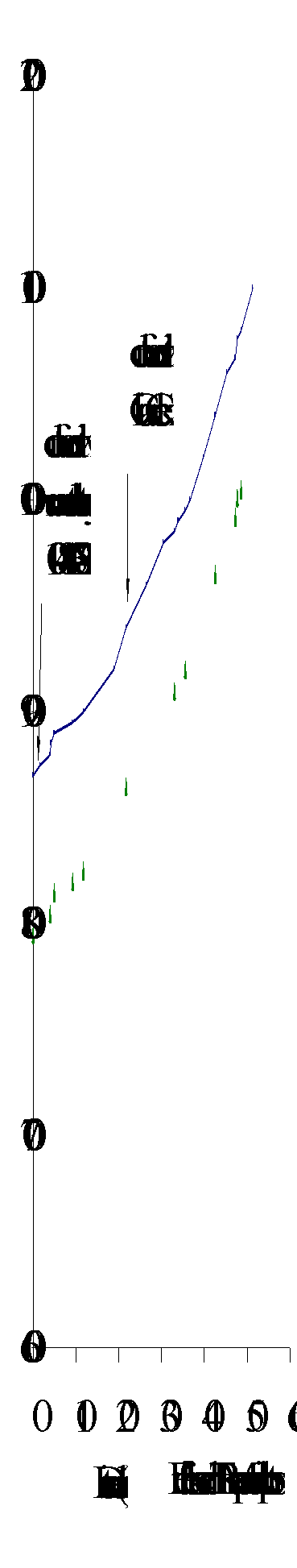 Victoria Creek
(100-4811-482) flows west into the Swift River, approximately 30 km upstream
of the Swift River and Lightning Creek confluence (Figure 19). The creek has
a mainstem length of approximately 54 km with 12 reaches delineated on the gradient
profile (Figure 20). The profile is based on reach breaks provided by the fish
inventory reconnaissance of Victoria Creek (Carmanah, 1996c). The elevation
ranges from 880 m at the Swift River confluence to 1080 m in its headwaters.
Victoria Creek meanders through a shallow valley in the Cariboo Plateau, and
drains an area of approximately 29,949 ha. Two tributaries were assessed; an
unnamed tributary (100-4811-308-173) is located 4 km upstream of the confluence
of Victoria Creek and the Swift River; Chiaz Creek is located 21 km upstream
of the confluence of Victoria Creek and the Swift River. Tributary 100-4811-308-173
has a mainstem length of 4.4 km and Chiaz Creek has a mainstem length of 15
km.
Victoria Creek
(100-4811-482) flows west into the Swift River, approximately 30 km upstream
of the Swift River and Lightning Creek confluence (Figure 19). The creek has
a mainstem length of approximately 54 km with 12 reaches delineated on the gradient
profile (Figure 20). The profile is based on reach breaks provided by the fish
inventory reconnaissance of Victoria Creek (Carmanah, 1996c). The elevation
ranges from 880 m at the Swift River confluence to 1080 m in its headwaters.
Victoria Creek meanders through a shallow valley in the Cariboo Plateau, and
drains an area of approximately 29,949 ha. Two tributaries were assessed; an
unnamed tributary (100-4811-308-173) is located 4 km upstream of the confluence
of Victoria Creek and the Swift River; Chiaz Creek is located 21 km upstream
of the confluence of Victoria Creek and the Swift River. Tributary 100-4811-308-173
has a mainstem length of 4.4 km and Chiaz Creek has a mainstem length of 15
km.
Figure 20. Gradient profile of Victoria Creek with 12 reaches delineated by triangles.
Chinook salmon, rainbow trout and bull trout are present in Victoria Creek (Figure 19). Other non-game species in the watershed are burbot, mountain whitefish, lake chub, longnose sucker and red-sided shiner. According to FISS (1994), chinook spawn in reach 5 of the Victoria Creek mainstem, however chinook fry have been located in tributaries that drain into reaches 7 and 8 (Carmanah, 1996c). It is therefore expected that chinook spawn up to reach 8. Chinook fry presence was noted in unnamed tributaries 100-4811-482-308, 100-4811-482-401, 100-4811-482-648 and 100-4811-482-642 (Carmanah, 1996c). Other tributaries that flow into reach 8 of the Victoria Creek mainstem are likely used as chinook rearing habitats. Rainbow trout occur throughout the mainstem and all wetted tributaries. While bull trout were not found during the 1996 Fish Inventory (Carmanah, 1996c), FISS (1994) data confirmed the presence bull trout in the mainstem and Chiaz Creek.
Victoria Creek is characterized by low amounts of forest harvesting and has been described as having no future developmental constraints (Carr et al., 1996). The ECA for this sub-basin is 6% (Dobson, 1996). All hazard indices for Victoria Creek that were calculated as part of the IWAP are low. The peak flow index was 0.14, the surface erosion index was 0.21, riparian buffer index was 0.20 and the landslide index was 0.10 (Dobson, 1996).
Carr et al. (1996) concluded that there are few sediment sources in the Victoria Creek sub-basin. Air photo analysis of the stream channel also showed no signs of channel disturbance. One streamside development was due to a private homestead in Reach 6. This area has been clearcut to the streambank for agricultural purposes and has erosion problems associated with livestock and human use of the stream.
Several roads that cross Chiaz Creek may be inhibiting fish passage. They have been rated as a low priority for sediment sources (Carr et al., 1996), but should be assessed as potential barriers to fish passage. AIM (1996) indicated in the Riparian, Wetland and Terrestrial Assessment that stream side impacts from adjacent logging were of low concern in the Victoria sub-basin. They found that most of the problems associated with riparian and wetland buffers were in areas with no fish present. A number of high hazard rating areas was noted in the upper reaches of the watershed that border fish-bearing streams (AIM, 1996). There are 56 active stream crossings in the Victoria Creek sub-basin (Dobson, 1996).
Habitat condition and preliminary assessment
The Habitat Condition Summary Form in Appendix C9 describes briefly the fish habitat in Victoria Creek. Habitat concerns are few. The main channel of Victoria Creek consists entirely of low gradient meandering streams (Carmanah, 1996b). Extensive marsh areas buffer the stream channel over a significant proportion of its length. No forest development related activities impact the mainstem of the creek. Table 9 summarizes the preliminary environmental impacts, priority for Level 1 assessments and restoration opportunities for Victoria Creek.
Table 9. Preliminary assessment of environmental impacts, priority for Level 1 assessment and restoration opportunities in Victoria Creek.
|
Sub Basin |
Reach |
Section |
Channel |
Channel |
Habitat |
Upslope |
Potential Impacts |
Priority‡ |
Restoration |
|||||||||
|
Name |
Num |
Type* |
Stability† |
Value‡ |
Impact‡ |
Opportunities |
||||||||||||
|
Victoria Creek |
1 |
RPgw |
S |
H |
L |
Riparian buffer removal. Logjams restricting access |
M |
Riparian Buffer rehab and erosion control / bioengineering, if necessary. Access restoration. |
||||||||||
|
2 3 |
RPgw |
S |
H |
L |
Logjams restricting access |
M |
Access restoration. |
|||||||||||
|
6 |
RPgw |
S |
H |
L |
Riparian buffer removal and eroding streambanks from agricultural development |
M |
Riparian Buffer rehab and erosion control / bioengineering, if necessary. |
|||||||||||
|
Unnamed tributary |
RPgw |
S |
H |
L |
Logging debris accumulation and fish passage and riparian buffer removal |
H |
Fish habitat and Riparian Buffer rehab., Debris removal, if necessary. |
|||||||||||
|
Unnamed tributary 100-4811-482-173 |
1 |
RPgw |
S |
H |
L |
Logging debris accumulation and fish passage and riparian buffer removal |
H |
Fish habitat and Riparian Buffer rehab., Debris removal, if necessary. |
||||||||||
|
3 4 5 |
RPgw |
S |
H |
L |
Riparian buffer removal |
L |
Riparian buffer rehabilitation, if necessary. |
|||||||||||
|
Chiaz Creek 100-4811-482-401 |
RPgw |
S |
H |
L |
Culvert passage and sedimentation from road ford |
M |
Restore access and erosion control / bioengineering, if necessary. |
|||||||||||
|
Unnamed tributary 100-4811-482-911 |
3 |
RPgw |
S |
H |
L |
Riparian Buffer removal and logging debris accumulation |
H |
Fish habitat and Riparian Buffer rehab., Debris removal, if necessary. |
||||||||||
The following briefly describes areas of concern on Victoria Creek on a reach basis. Several logjams and beaver dam complexes along the mainstem may be obstructions to fish migration. Reach 1 has two logjams, reach 2 has four and reach 3 has one. These logjams appear to be spanning the channel. There are no direct logging sources that could introduce this amount of material into the channel. However, several tributaries close to reach 1 were logged to the streambank and may be contributing to the woody debris in the mainstem. Unnamed tributary 100-4811-482-173, which drains Robertson Lake, has been logged to the streambank along its southern edge (Carmanah, 1996c). This tributary is a potential debris source that may be providing the woody debris for the logjams. This should be confirmed in the Level 1 assessment.
Sediment introduction via most tributaries where harvesting has taken place is not a habitat concern. Most of the channels of tributaries are consistent with the low gradient meandering channel of the Victoria Creek mainstem, and as such they have a low capacity for sediment transport and channel destabilization.
One small agricultural homestead located in reach 6 of the mainstem is having the only significant impact on the Victoria Creek mainstem (Site 1, Carmanah, 1996c). Clearing and active use of the streambanks is evident from air photos. Bank erosion and mid-channel bars are presented adjacent to and immediately downstream of this area. Pool habitat impacts are limited to the local area. These impacts do not seem to be affecting the lower reaches in the Victoria Creek mainstem.
Restoration opportunities on Victoria Creek include improving fish passage through logjams identified as being fish obstructions, riparian planting along cleared banks and localizing sediment control on homestead in partnership with local title holder.
The following tributaries have been selected based on fish presence, amount of logging activity, hazard ratings and connectivity to the mainstem.
Unnamed Tributary
This unnamed tributary (no watershed code) is very small and is located below the 300 road crossing reach 2 of Victoria Creek. This small stream flows through a large clearcut and across the 300 road through a culvert, dropping 0.75m onto rocks before winding its way through a patch of old growth and into Victoria Creek (Carmanah, 1996c). Carmanah (Site 2, 1996c) identified chinook rearing in this tributary below the culvert. The lower portion of this tributary was noted to be clogged with logging related debris it may be transporting to the mainstem. Channel and habitat condition and characteristics were not discernable from air photo analysis.
Unnamed tributary
The unnamed tributary 100-4811-482-173 drains Robertson Lake into the upper limit of reach 3 of Victoria Creek. It is outside of the TFL 52 operating area, and was logged along its entire length in the late 1970’s. Reach 1 is confined within steep valley walls and was logged to the streambank on the southern edge. AIM (1996) rated this reach as very high in terms of riparian habitat impacts. It appears to be clogged with debris, and the streambank is slumping. It is expected that chinook rear in this portion of the creek.
Robertson Creek flows into the tributary as it drains from Robertson Lake. Robertson Creek has also been logged to its banks in the late 1970’s. Reaches 3 through 5 of the Robertson Creek run through a large cutblock. Both tributaries contain rainbow trout and possibly bull trout. Carmanah (Site 3, 1996c) identified adequate pools and covered habitat in these tributaries. Logging related debris transported from this area into Victoria Creek might be a concern, although it is not expected to be significant.
Chiaz Creek
Chiaz Creek (100-4811-482-401), the largest tributary to Victoria Creek, has a low amount of forest harvesting. The lower reaches contain chinook salmon. Road networks traverse this creek in upper reaches and Carr et al. (1996) indicated that there are several concerns related to the roads. The first crossing of interest is approximately 5 km northwest of the 4924 marker on the 4900 road (Site 4, Carmanah, 1996c). There are two more crossings immediately after this site along the same road that have been identified as having blockage and damming concerns (Sites 5 and 6, Carmanah, 1996c). Additionally, an old road fords one of the creeks just below the 4900 road (Site 7, Carmanah, 1996c). These sites should be assessed as part of a Fish Passage and Culvert Inspection.
Unnamed tributary
The unnamed tributary 100-4811-482-911 has a low gradient channel and joins Victoria Creek at the upper limit of reach 10. A large cutblock located along reach 3 of this tributary has been logged to the streambank (Site 8, Carmanah, 1996c). AIM (1996) rated this tributary as a site with high riparian habitat impacts, as approximately 1.32 km of riparian buffer is missing. In spite of adjacent harvesting, fish habitat impacts are low due to the low gradient of the stream. However, local fish habitat impacts such as debris accumulations may be of concern. This tributary should be included in a Site Level Riparian Assessment Procedure and should be assessed for fish habitat impacts.
Restoration opportunities on tributaries of Victoria Creek include fish passage improvement in tributaries, riparian buffer rehabilitation, logjam passage and access restoration in the mainstem and debris removal. This watershed is a moderate priority for fish habitat rehabilitation based on overall fish access concerns, levels of impact and the condition of the fish habitat.
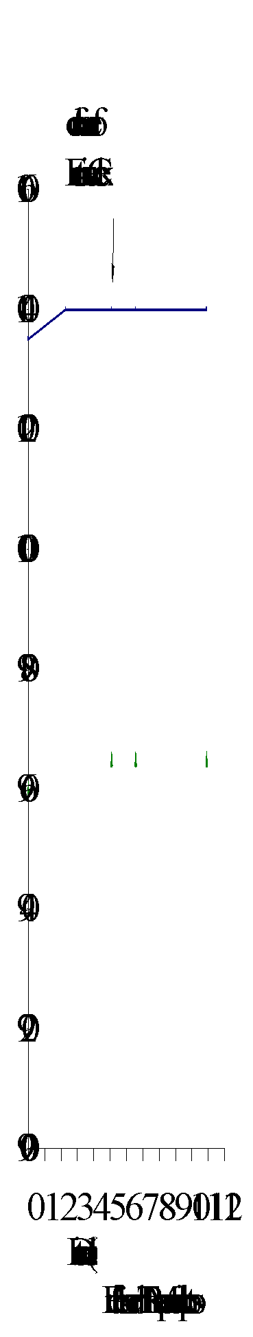 Reddish Creek
(100-4811-729) flows south into the Swift River, 52 km upstream of the
Swift River and Lightning Creek confluence (Figure 21). The mainstem has a length
of approximately 11 km with three reaches delineated by the gradient profile
(Figure 22). The profile is based on reach breaks provided by the fish inventory
reconnaissance of Reddish Creek (Carmanah, 1996a). The elevation ranges from
1035 m at the Swift River confluence to 1040 m in its headwaters, with Fontaine
Creek headwaters at an elevation of 1560 m. Reddish Creek lies within a valley
in the Cariboo Plateau, and drains an area of 7,245 ha (Dobson, 1996). Fontaine
Creek is a tributary that flows into Reddish Creek 4.5 km upstream of the Reddish
Creek and Swift River confluence.
Reddish Creek
(100-4811-729) flows south into the Swift River, 52 km upstream of the
Swift River and Lightning Creek confluence (Figure 21). The mainstem has a length
of approximately 11 km with three reaches delineated by the gradient profile
(Figure 22). The profile is based on reach breaks provided by the fish inventory
reconnaissance of Reddish Creek (Carmanah, 1996a). The elevation ranges from
1035 m at the Swift River confluence to 1040 m in its headwaters, with Fontaine
Creek headwaters at an elevation of 1560 m. Reddish Creek lies within a valley
in the Cariboo Plateau, and drains an area of 7,245 ha (Dobson, 1996). Fontaine
Creek is a tributary that flows into Reddish Creek 4.5 km upstream of the Reddish
Creek and Swift River confluence.
Figure 22. Gradient profile of Reddish Creek with three reaches delineated by triangles.
Rainbow trout reside throughout Reddish and Fontaine creeks (Carmanah, 1996c; Appendix B10; Figure 21). Non-game species include lake chub and longnose sucker. Several tributaries to Reddish and Fontaine creeks also have rainbow trout (Carmanah, 1996c). Horan Creek, a first order tributary to Fontaine Creek, has rainbow trout throughout. An unnamed tributary (100-4811-729-577) of Reddish Creek contains rainbow trout into reach 4 and in the two small lakes that feed the tributary (Carmanah, 1996c).
Reddish and Fontaine creeks are approximately the same size. Both are characterized by a large amount of forest development activity. The Cottonwood/Swift River IWAP report stated that the ECA for this sub-basin is 29.4% (Dobson, 1996). The hazard ratings for this sub-basin are high, with peak flow index at 0.73, surface erosion hazard index at 0.70 and riparian buffer index at 0.91. The landslide hazard index was rated low, as there were no slope failures in the sub-basin. Road densities in this sub-basin are high at 1.05 km per square km (Dobson, 1996). There are 45 active stream crossings in the Reddish Creek sub-basin (Dobson, 1996).
Carr et al. (1996) indicated several problems in the Reddish Creek sub-basin. Seven of 27 forestry related sources are classified as high risk for sediment generation that appears to be significantly impacting water quality (Carr et al., 1996). They also identified the Reddish Creek sub-basin as a high priority sub-basin in the Cottonwood River watershed for road and slope rehabilitation.
AIM (1996) rated seven areas in Reddish Creek sub-basin with high to very high riparian habitat impacts. The biggest impacted area was along the Fontaine Creek mainstem, where a buffer of less than one tree width on one side and no buffer on the other extends for 2.49 km. Other impacted riparian and wetland areas occurred in reach 3 of Reddish Creek, tributary 100-4811-729-577 and Horan Creek (AIM, 1996).
Habitat condition and preliminary assessment
A low gradient sinuous stream channel along its entire length characterizes Reddish Creek. The Habitat Condition Summary form in Appendix C10 describes briefly the stream habitat conditions based on available data. Extensive wetland floodplains occur along the mainstem. Fish habitat along all reaches of Reddish Creek is characterized as riffle-pool with extensive side channel and clumped woody debris habitats. There is no evidence of channel changes and habitat impacts associated with forestry activities. Impacts of forest harvesting are confined to wetland habitats. Table 10 gives a brief summary of the preliminary assessment of environmental impacts, assigned priority for Level 1 assessment and potential restoration opportunities.
|
Sub Basin |
Reach |
Section |
Channel |
Channel |
Habitat |
Upslope |
Potential Impacts |
Priority‡ |
Restoration |
|
Name |
Num |
Type* |
Stability† |
Value‡ |
Impact‡ |
Opportunities |
|||
|
Reddish Creek 100-4811-729 |
1 |
RPgw |
A |
H |
L |
The road that crosses the creek may inhibit fish passage. |
M |
Assess the culvert for fish access. |
|
|
2 |
RPgw |
S |
H |
L |
Cutblock has been clearcut to streambank causing loss of wetland riparian buffer. Placer mining point sediment sources |
H |
Re-vegetation or bioengineering or rehabilitation of the riparian area, if necessary. |
||
|
3 |
RPgw |
S |
H |
L |
Cutblock has been clearcut to streambank causing loss of wetland riparian buffer. Tributaries that have been harvested may be impacting fish habitat. |
H |
Assessment of wetland habitat and tributaries for impacts on fish habitat. |
||
|
Fontaine Creek 100-4811-729-473 |
1 |
RPgw |
U |
M |
U |
Cutblock has been clearcut to streambank causing loss of wetland riparian buffer. The road that crosses the creek may inhibit fish passage. |
H |
Re-vegetation or bioengineering or rehabilitation of the riparian area, if necessary. |
|
|
2 |
RPgw |
U |
H |
L |
Placer mining point sediment sources |
H |
|||
|
4 |
RPcw |
U |
H |
H |
Cutblock has been clearcut to streambank causing loss of wetland riparian buffer. |
H |
Re-vegetation or bioengineering or rehabilitation of the riparian area, if necessary. |
||
|
5 |
RPcw |
U |
H |
L |
Cutblock has been clearcut to streambank causing loss of wetland riparian buffer |
H |
Re-vegetation or bioengineering or rehabilitation of the riparian area, if necessary |
||
|
6 |
RPcw |
U |
H |
H |
Cutblock has been clearcut to streambank causing loss of wetland riparian buffer. |
H |
Re-vegetation or bioengineering or rehabilitation of the riparian area, if necessary. |
||
|
Horan Creek 100-4811-729-473-503 |
1 2 |
Cutblock has been clearcut to streambank and logging has occurred through the stream causing loss of wetland riparian buffer. |
H |
Re-vegetation or bioengineering or rehabilitation of the riparian area, if necessary. |
|||||
The following briefly describes areas of concern on Reddish Creek on a reach basis. The 13N main access road crossing of Reddish Creek in reach 1 shows evidence of debris damming and pooling above the bridge. Fish passage and blockage should be checked at this site. Forest cover has been removed along reach 2 as a result of forestry and mining related activities. The reach should be assessed for impacts on fish habitat. Reach 3 of Reddish Creek has a 2.6 km wetland and lacks a buffer zone along the old cutblock boundary. There is no evidence of fish habitat impacts. Wetland habitat impacts of the adjacent cutblock should be addressed. During the helicopter reconnaissance over reach 3, high turbidity was noted in the creek. The sediment source was traced to a "small business" road being upgraded on the forested hillside above the creek. Sediment from the road was being transported into the creek from small tributaries and runoff.
Restoration opportunities in the Reddish Creek sub-basin include rehabilitating the riparian buffer along 2.5 km of impacted wetlands in reach 3 and restoring fish passage throughout the sub-basin.
Fontaine Creek has a mainstem length of 12 km with six reaches delineated in the gradient profile (Figure 23). The creek is about the same size as Reddish Creek and has significant impacts due to logging activities and two small placer mining operations located along the creek. Reach 1 flows past the 13N road crossing through wetland habitats to Reddish Creek (Photo 3). In the 100 m below the bridge crossing the creek is confined and has a low amount of cover (Site 3, Carmanah, 1996a).
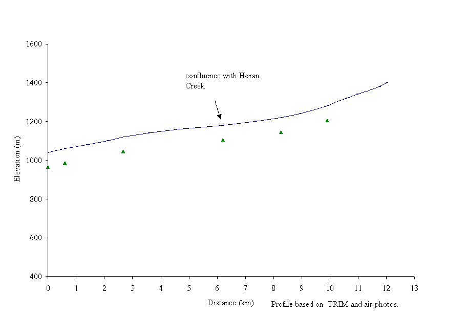 Figure 23. Gradient profile
of Fontaine Creek with six reaches delineated by triangles.
Figure 23. Gradient profile
of Fontaine Creek with six reaches delineated by triangles.
Reach 2 of Fontaine Creek is not impacted by forest development, however two small placer mining operations are located at the upper and lower end of this reach (Site 4 and 5, Carmanah, 1996a). Their impact on fish habitat and water quality is unknown and should be quantified.
Reach 4 is the priority area in this sub-basin because it has been extensively logged along the streambank. The lower portion of reach 4 has an old logging road crossing and a beaver dam. A 10 m2 section of bank was noted by inventory crews to be slumping into the creek (Site 6, Carmanah, 1996b). Some riparian areas were harvested to the streambank initially from 1964 through to 1969, and more was harvested in 1987. The forest was harvested to the streambank on the northwest side, and the stream has been left with an inadequate riparian buffer (Photo 4). This cutblock is bordered on the north by Horan Creek, a small tributary of Fontaine Creek. The lower reaches of Horan Creek are in this cutblock and have been logged to their streambanks. Approximately 2.5 km of the impacted riparian area and the associated fish bearing streams are within this particular cutblock.
Forest harvesting of riparian buffers has impacted reach 2 of Horan Creek, which contains rainbow trout. A 1991 cutblock at the upper end of reach 2 appears to impact the fish-bearing creek (Site 7, Carmanah, 1996a). This reach of Horan Creek should be assessed as part of a Riparian Site Assessment. A culvert crossing at the upper end of Horan Creek has been noted as a fish barrier (Carmanah, 1996a).
Reach 5 of Fontaine Creek has a 1.49 km section with no riparian buffer between a cutblock harvested in 1982 and the wetland next to the creek (Carmanah, 1996a). Fish habitat impacts from the cutblock and loss of riparian buffer are low due to the buffering effect of the wetland between the cutblock and stream.
Reach 6 of Fontaine Creek was logged along its southern streambank, with approximately 3 km of the riparian area removed. Rainbow trout are present in this reach. Logging activities have caused the steep creek banks to slump in places along this reach, as noted during the aerial reconnaissance.
Photo 3. A stream crossing in reach 1 that may be a sediment source to the Reddish Creek mainstem.
Photo 4. The riparian area has been clearcut along reach 4 of Fontaine Creek.
Restoration opportunities in the Reddish Creek sub-basin include fish habitat restoration and bank stabilization or bioengineering, riparian buffer rehabilitation and fish passage restoration. The Reddish Creek sub-basin is considered a high priority for fish habitat rehabilitation based on overall levels of impact and the condition of fish habitat. Priority for Level 1 assessment is high due to the overall degree of channel and riparian impacts.
The McMartin Sub-basin is the catchment area for the upper Swift River (100-4811). It contains several second order creeks including McMartin Creek, its namesake. This section of the Swift River flows west into the Swift River approximately 55 km upstream of the Swift River and Lightning Creek confluence (Figure 24). The sub-basin has a mainstem length of 37 km with nine reaches delineated by the gradient profile (Figure 25). The McMartin Sub-basin has an area of 16,080 ha (Dobson, 1996).

According to FISS (1994), rainbow and bull trout are found throughout the McMartin Sub-basin (Appendix B11; Figure 24). Bull trout are also found in McMartin Creek, Barr Creek and Aster Creek, which are second order tributaries of the upper Swift River (Imhof and Sutherland, 1996).
The McMartin Sub-basin is characterized by a moderate amount of forest development with minimal impacts on the stream. Forests in the lower reaches have been clearcut to the streambank. Logging roads have opened the upper areas of the sub-basin for forest harvesting with few impacts. The Cottonwood/Swift River IWAP indicated that the ECA for McMartin Sub-basin was low (Dobson, 1996). Based on a highest rating of 1.00, the hazard index for peak flow was 0.28, surface erosion was 0.17, riparian buffer was 0.07 and landslide was 0.00. Dobson (1996) stated that portions of the stream channels in the McMartin Sub-basin has a high percentage of exposed erodible soils.
Carr et al. (1996) described 48 sediment sources in the McMartin Sub-basin; 56% were man-made, and all were associated with forest development. Three were high risk. They recommended road or block deactivation and drainage restoration to address the forestry-related problem sites. The natural instability of the river channel identifies the need to address forestry related problems in this sub-basin.
AIM (1996) stated that there was about 12.5 km of stream that was missing riparian buffers. Riparian areas are inadequate along reaches 2 and 3 of the mainstem.
Habitat condition and preliminary assessment
The McMartin Sub-basin is characterized by a low gradient sinuous stream channel in the lower reaches. The upper reaches in the sub-basin flow from the alpine regions of the Cottonwood River watershed. The Habitat Condition Summary form in Appendix C11 gives a general description of the stream habitat conditions based on available data. Habitat concerns include sediment input from roads and inadequate riparian areas in reaches 2, 3 and 4. Table 11 gives a brief summary of the preliminary assessment of environmental impacts, assigned priority for Level 1 assessment and potential restoration opportunities.
|
Sub Basin |
Reach |
Section |
Channel |
Channel |
Habitat |
Upslope |
Potential Impacts |
Priority‡ |
Restoration |
|
Name |
Num |
Type* |
Stability† |
Value‡ |
Impact‡ |
Opportunities |
|||
|
McMartin 100-4811 |
2 |
RPcw |
S |
H |
H |
The bridged road that crosses the creek may be impacting fish habitat. Historical harvesting into the riparian area. |
H |
Assess the bridge and riparian area for potential impacts on fish habitat. |
|
|
4 |
RPcw |
S |
H |
H |
Harvesting into the riparian area. |
H |
Re-vegetated or bioengineer the riparian area, if necessary. |
The following briefly describes areas of concern in the McMartin Sub-basin on a reach basis based on available data. The channel of the Swift River retains its meandering nature as a pool and riffle habitat with gravel and woody debris in reaches 1 and 2 of the McMartin Sub-basin. Imhof and Sutherland (1996) described the channel in reach 1 as a run type habitat with deep pools throughout. The creek bed was composed of mostly fines and some gravel. Reach 2 of the McMartin Sub-basin contains a bridge crossing that is a potential sediment source and may be impacting fish habitat. Forest cover has been removed from the streambanks in 1977, resulting in an inadequate riparian buffer. The forest along this reach has a non-productive brush area. The fish habitat of pools and riffles in reaches 3 through 6 contains cobble with some large organic debris. Logging activity during 1982 and 1991 along reach 4 has removed the riparian vegetation and should be assessed to quantify fish habitat. The river channel in reaches 7 and 8 is composed of cascades and pools with some cobble and woody debris as the gradient increases.
Recommendations
Restoration opportunities in the McMartin Sub-basin include re-vegetation of riparian areas and streambank stabilization or bioengineering. The McMartin Sub-basin is considered a moderate priority for fish habitat rehabilitation based on overall levels of impact and the condition of fish habitat.
 The Little
Swift River flows west to the Swift River, 55 km upstream of the confluence
of the Swift River and Lightning Creek (Figure 26). The river has a mainstem
length of 29 km with 14 reaches delineated by the gradient profile (Figure 27).
The Little Swift River drains a watershed area of 13,118 ha (Dobson, 1996).
The Water Survey of Canada gauging station 08KE024 documented the annual flow
at 2.75 m3 s-1 (Rood and Hamilton, 1995).
The Little
Swift River flows west to the Swift River, 55 km upstream of the confluence
of the Swift River and Lightning Creek (Figure 26). The river has a mainstem
length of 29 km with 14 reaches delineated by the gradient profile (Figure 27).
The Little Swift River drains a watershed area of 13,118 ha (Dobson, 1996).
The Water Survey of Canada gauging station 08KE024 documented the annual flow
at 2.75 m3 s-1 (Rood and Hamilton, 1995).
Figure 27. Gradient profile of the Little Swift River with 14 reaches delineated by triangles.
Rainbow trout are found in the lower eight reaches of the Little Swift River (Appendix B12; FISS, 1994; Figure 26). A waterfall may act as a barrier to fish migration upstream of reach 9, but resident fish are suspected in the upper reaches. Bull trout also reside in the river (Imhof and Sutherland, 1996). There are several potential road-related barriers on second-order tributaries that contain rainbow and bull trout (Imhof and Sutherland, 1996).
A low amount of forest development and a moderate amount of natural slumping of riverbanks characterize Little Swift River. The Cottonwood/Swift River IWAP indicated that the ECA for the Little Swift River sub-basin was low (Dobson, 1996). Based on a highest rating of 1.00, the hazard index for peak flow was 0.45, surface erosion was 0.42, riparian buffer was 0.36 and mass wasting was 0.04. Dobson (1996) stated that the stream channels in the Little Swift River sub-basin did not have high percentages of exposed erodible soils. AIM (1996) stated that approximately 18% of the sub-basin had been logged and approximately 4.7 km of river had been left with inadequate riparian buffers.
Carr et al. (1996) described 62 sediment sources in the Little Swift River sub-basin; 73% are man-made with 68% associated with forest development. Thirteen of 42 sediment problems are high risk and are caused by forest harvesting. They recommended road or block deactivation and drainage restoration to address the forestry-related problem sites. The natural instability of the river channel identifies the need to address forestry-related problems in this sub-basin.
Habitat condition and preliminary assessment
The Little Swift River is characterized by extensive riffle and pool habitat in a broad flood plain in its lower reaches. The Habitat Condition Summary form in Appendix C12 gives a general description of the stream habitat conditions. Habitat concerns are related to increased sediment input into the river in reaches 2 and 3. Table 12 gives a brief summary of the preliminary assessment of environmental impacts, assigned priority for Level 1 assessment and potential restoration opportunities.
|
Sub Basin |
Reach |
Section |
Channel |
Channel |
Habitat |
Upslope |
Potential Impacts |
Priority‡ |
Restoration |
|
Name |
Num |
Type* |
Stability† |
Value‡ |
Impact‡ |
Opportunities |
|||
|
Little Swift 100-4811-746 |
2 |
RPcw |
A |
H |
H |
The bridged road that crosses the creek may be impacting fish habitat. The mine along the reach has an inadequate riparian area. |
H |
Re-vegetation and bioengineering of the river bank to limit impacts on fish habitat, if necessary. |
|
|
3 |
CPcw |
A |
H |
H |
The mine along the reach has an inadequate riparian area. |
H |
Re-vegetation or bioengineering of the riparian area, if necessary. |
||
|
6 |
RPcw |
S |
H |
L |
Logging activity has impacted the riparian area. |
H |
Assess the bridge and riparian area for potential impacts on fish habitat. |
||
|
7 |
RPcw |
S |
H |
L |
Logging activity has impacted the riparian area. |
H |
Assess the bridge and riparian area for potential impacts on fish habitat. |
The following briefly describes areas of concern on the Little Swift River on a reach basis based on available data. The channel of the Little Swift River in reaches 1 through 3 has been altered by mining activity. The fish habitat in reach 1 is composed mostly of runs and riffles that have been aggraded by gravel. Several areas within the meandering floodplain contain fish habitat associated with large organic debris, which serves to maintain channel morphology (Imhof and Sutherland, 1996). In reach 2 the river channel is characterized by riffles with a few pools. The channel contains cobble and a few pieces of woody debris. Imhof and Sutherland (1996) described that most cover is provided by cutbanks. The riverbed, in reach 2, is composed of 65% gravel. The bridged road crossing in this reach may be a potential sediment source and should be assessed. The riparian vegetation along the mine site has been removed and sediments appear to run freely into the creek. These reaches should be assessed for fish habitat impacts. In reaches 3 though 5 the channel has a gradient of 7% and is characterized by cascades and pools with some woody debris and cobble. The upper reaches of the river are characterized by riffle and pool channel morphology. The creek bed is composed mostly of large cobble and some gravel. The riparian vegetation along reaches 6 and 7 has been removed and the reaches should be assessed for impacts on fish habitat.
Restoration opportunities on the Little Swift River include re-vegetation of the river bank along cutblocks and stabilization of the river banks at mine sites.
Summary of recommendations for priority Level 1 Assessments
The following table presents a list of the high and medium priority reaches recommended for field examination in the Cottonwood River watershed. High priority reaches are those having high value fish habitat and adjacent or upstream development that has had, or is suspected of having, an impact on fish habitat. Medium priority reaches are those that met the above criteria but which have a lower fish habitat value. Since the impacted areas are identified from an office-based activity, field verification is necessary to confirm recommendations. Priority assignments may be re-evaluated upon field visitation; if the priority drops, additional sites should be evaluated as time permits.
Table 13. Summary of Level 1 FHAP recommendations
|
Sub-basin name |
Reach |
Potential impact |
Priority for level 1 |
Restoration opportunities |
Species |
|
Cottonwood Residual |
|||||
|
Cottonwood Residual 100-4811 |
1 |
Rural developments may have encroached on the riverbank causing slumping of the banks. |
H |
Bank stabilisation and re-vegetation of the riverbank, if necessary. |
CH, CO, PK, RB, MW, BT |
|
2 |
The bridged highway that crosses the reach and the right-of way for the 3-tower Hydro line should be assessed for fish habitat impacts. |
M |
Re-vegetation or bioengineering of the riverbank to limit impacts on fish habitat and assess for fish passage, if necessary. |
CH, CO, RB, MW. BT |
|
|
4 |
The bridged road that crosses the reach should be assessed for habitat impacts. Mining activity has cleared the riparian area from the streamside. |
H |
Re-vegetation or bioengineering of the crossing and riparian area, if found to impacting fish habitat, if necessary. |
CH, CO, RB, MW, BT |
|
|
5 |
The bridged road that crosses the reach should be assessed for habitat impacts. |
M |
Re-vegetation or bioengineering of the crossing, if necessary. |
CH, CO, RB, MW, BT |
|
|
6 |
Mining activity has cleared the riparian area along the south bank of the creek |
H |
Bank stabilisation and re-vegetation of the streambank, if necessary. |
CH, CO, RB, MW, BT |
|
|
7 |
Logging activity has clearcut to the streamside. Mining activity has cleared the riparian area from the streamside. |
H |
Re-vegetation or bioengineering of the riparian area to stabilise the streambanks, if found to be impacting fish habitat. |
CH, CO, RB, MW, BT |
|
|
8 |
The bridged road that crosses the reach should be assessed for habitat impacts. Logging activity has clearcut to the streamside. |
H |
Re-vegetation or bioengineering of the river bank to limit impacts on fish habitat, if necessary. |
CH, CO, RB, MW, BT |
|
|
Sub-basin name |
Reach |
Potential impact |
Priority for level 1 |
Restoration opportunities |
Species |
|
|
Ahbau Creek |
||||||
|
Ahbau Creek 100-4811-073 |
1 |
The bridged highway that crosses the reach should be assessed for fish habitat impacts. |
M |
Re-vegetation and bioengineering of the river bank to limit impacts on fish habitat, if necessary. |
CH, RB |
|
|
2 |
Logging activity has clearcut to the streamside. Natural slumping of creek banks. Rural developments may have encroached on the riverbank causing slumping of the banks. |
H |
Re-vegetation and bioengineering of the river bank to limit impacts on fish habitat if necessary. Bank stabilisation and re-vegetation of the riverbank, if necessary. |
CH, RB |
||
|
4 |
The hydrolines and B.C. railway that cross the reach should be assessed for fish habitat impacts. |
M |
Re-vegetation and bioengineering of the river bank to limit impacts on fish habitat, if necessary. |
CH, RB |
||
|
10 |
The road that crosses the creek should be assessed for fish habitat impacts. Logging activity has clearcut to the stream side |
M |
Re-vegetation and bioengineering of the river bank to limit impacts on fish habitat, if necessary. |
RB |
||
|
12 |
The road that crosses the creek should be assessed for fish habitat impacts. Logging activity has clearcut to the stream side |
M |
Re-vegetation and bioengineering of the river bank to limit impacts on fish habitat, if necessary. |
RB suspected |
||
|
Ahbau Creek first unnamed tributary |
1 |
Logging activity may have impacted the riparian vegetation. |
H |
Modification of road crossing if found to be a barrier to fish migration, if necessary. |
RB suspected |
|
|
2 |
Historic logging activity may have impacted the riparian vegetation. The road that crosses the creek should be assessed for fish habitat impacts. |
H |
Modification of road crossing if found to be a barrier to fish migration, if necessary. |
RB suspected |
||
|
Nelson Kenny Creek |
||||||
|
Nelson Kenny Creek 100-4811-073-010 |
1 |
The bridged road that crosses the creek should be assessed for fish habitat impacts. Historical logging activity has clearcut to the streamside. Agricultural activities have also impacted the riparian area |
H |
Re-vegetation and bioengineering of the river bank to limit impacts on fish habitat, if necessary. |
CH |
|
|
2 |
The road that crosses the creek should be assessed for fish habitat impacts. Historical logging activity has clearcut to the streamside. Agricultural activities have also impacted the riparian area |
H |
Re-vegetation and bioengineering of the river bank to limit impacts on fish habitat, if necessary. |
CH |
||
|
3 |
The bridged road that crosses the creek should be assessed for fish habitat impacts. |
M |
Re-vegetation and bioengineering of the river bank to limit impacts on fish habitat, if necessary. |
Suspected CH |
||
|
Sub-basin name |
Reach |
Potential impact |
Priority for level 1 |
Restoration opportunities |
Species |
||
|
Umiti Creek |
|||||||
|
Umiti Creek 100-4811-287 |
1 |
The bridged road that crosses the creek should be assessed for fish habitat impacts |
M |
Re-vegetation and bioengineering of the river bank to limit impacts on fish habitat, if necessary. |
Suspected CH |
||
|
2 |
The bridged road that crosses the creek should be assessed for fish habitat impacts. Historic logging activity has clearcut to the streamside. |
H |
Re-vegetation and bioengineering of the river bank to limit impacts on fish habitat, if necessary. Re-vegetation of riparian area. |
Suspected CH |
|||
|
3 |
The bridged road that crosses the creek should be assessed for fish habitat impacts. Historic logging activity has clearcut to the streamside. |
H |
Re-vegetation and bioengineering of the river bank to limit impacts on fish habitat, if necessary. Re-vegetation of riparian area. |
Suspected CH |
|||
|
4 |
The bridged road that crosses the creek should be assessed for fish habitat impacts. Historic logging activity has clearcut to the streamside. |
H |
Re-vegetation and bioengineering of the river bank to limit impacts on fish habitat, if necessary. Re-vegetation of riparian area. |
Suspected CH |
|||
|
5 |
The bridged road that crosses the creek should be assessed for fish habitat impacts. Historic logging activity has clearcut to the streamside. |
H |
Re-vegetation and bioengineering of the river bank to limit impacts on fish habitat, if necessary. Re-vegetation of riparian area. |
Suspected CH |
|||
|
Umiti Creek (unnamed tributary) |
1 |
The bridged road that crosses the creek should be assessed for fish habitat impacts. Logging activity has clearcut to the streamside along portions of reaches. |
H |
Re-vegetation and bioengineering of the river bank to limit impacts on fish habitat, if necessary. Re-vegetation of riparian area. |
CH suspected |
||
|
John Boyd Creek |
|||||||
|
John Boyd Creek 100-4811-308 |
1 |
The road that crosses the reach may be impacting fish habitat. |
M |
Re-construction or modification of the crossing , if necessary |
CH, RB |
||
|
2 3 |
The riparian area has been clearcut to the streamside. |
H |
Re-vegetation of riparian area, if necessary. |
CH, RB |
|||
|
4 |
The bridged road that crosses the reach may be impacting fish habitat. The riparian area has been clearcut to the streamside. |
H |
Re-construction or modification of the bridge, if necessary. Re-vegetation of riparian area, if necessary. |
CH, RB |
|||
|
5 |
The riparian area has been clearcut to the streamside. |
H |
Re-vegetation of riparian area, if necessary. |
CH, RB suspected |
|||
|
6 |
The road that crosses the reach may be impacting fish habitat. |
M |
Re-construction or modification of the crossing , if necessary |
CH, RB suspected |
|||
|
John Boyd Creek Unnamed trib. |
1 |
The riparian area has been clearcut to the streamside. |
H |
Re-vegetation of riparian area, if necessary. |
CH suspected |
||
|
2 |
The road that crosses the reach may be impacting fish habitat. The riparian area has been clearcut to the streamside. |
H |
Re-construction or modification of the crossing, if necessary. Re-vegetation of riparian area. |
CH suspected |
|||
|
Alice Creek 100-4811-308-511 |
1 |
The riparian area has been clearcut to the streamside. |
H |
Re-vegetation of riparian area, if necessary. |
CH suspected |
||
|
2 3 |
The road that crosses the reach may be impacting fish habitat. The riparian area has been clearcut to the streamside. |
H |
Re-construction or modification of the crossing, if necessary. Re-vegetation of riparian area. |
CH suspected |
|||
|
Sub-basin name |
Reach |
Potential impact |
Priority for level 1 |
Restoration opportunities |
Species |
|||
|
Mary Creek 100-4811-308-511-079 |
1 2 3 4 5 |
The road that crosses the reach may be impacting fish habitat. The riparian area has been clearcut to the streamside. |
H |
Re-construction or modification of the crossing, if necessary. Re-vegetation of riparian area. |
CH suspected |
|||
|
Lightning Creek |
||||||||
|
Lightning Creek 100-4811-389 |
1 2 3 4 |
The roads that cross and parallel the reach may be causing limitations to fish habitat. |
H |
Re-construction or modification of the roads and crossing, if necessary. |
CH, RB, BT |
|||
|
5 |
The riparian area has been clearcut to the streamside. |
H |
Re-vegetation of riparian area, if necessary. |
CH, RB, BT |
||||
|
Peters Creek 100-4811-389-605 |
1 |
The road that crosses the reach may be a barrier to fish migration or impact fish habitat. |
M |
Re-construction or modification of the culvert to allow fish passage if found to be a migration barrier |
RB |
|||
|
2 |
The road that crosses the reach may be a potential barrier to fish migration. The riparian area has been clearcut to the streamside. |
H |
Re-construction or modification of the culvert to allow fish passage if found to be a migration barrier. Re-vegetation of riparian area. |
RB |
||||
|
Beaver Pass Creek 100-4811-389-496 |
1 |
The road that crosses the reach may be a barrier to fish migration. |
M |
Re-construction or modification of the culvert to allow fish passage if found to be a migration barrier |
RB suspected |
|||
|
2 3 |
The riparian area has been clearcut to the streamside. |
H |
Re-vegetation of riparian area, if necessary. |
RB suspected |
||||
|
Swift River |
||||||||
|
Swift River 100-4811 |
1 |
Agricultural and mining impacts have removed portions of the riparian area from the streamside. Natural slumping of riverbank. |
H |
Re-vegetation of riparian area and bank stabilisation, if necessary. |
CH, RB |
|||
|
3 |
Historical forestry, agricultural and mining impacts have removed portions of the riparian area from the streamside. Natural slumping of riverbank. |
H |
Re-vegetation of riparian area and bank stabilisation, if necessary. |
CH, RB |
||||
|
6 |
Agricultural impacts have removed portions of the riparian area from the streamside. Natural slumping of riverbank. |
H |
Re-vegetation of riparian area and bank stabilisation, if necessary. |
CH, RB |
||||
|
8 9 |
The riparian area has been clearcut to the streamside. |
H |
Re-vegetation of riparian area, if necessary. |
CH, RB |
||||
|
Unnamed tributary 100-4811-426 |
1 |
Historical streamside harvesting has impacted the riparian buffer. |
H |
Re-vegetation of riparian area, if necessary. |
RB |
|||
|
2 |
The road that crosses the reach may be a potential barrier to fish migration. Historical streamside harvesting has impacted the riparian buffer. |
H |
Re-construction or modification of the culvert to allow fish passage if found to be a migration barrier. Re-vegetation of riparian area, if necessary |
CH, RB |
||||
|
4 |
Historical streamside harvesting has impacted the riparian buffer. |
H |
Re-vegetation of riparian area, if necessary |
CH, RB |
||||
|
6 |
The road that crosses the reach may be a potential barrier to fish migration. Historical streamside harvesting has impacted the riparian buffer. |
H |
Re-construction or modification of the culvert to allow fish passage if found to be a migration barrier. Re-vegetation of riparian area, if necessary |
CH, RB |
||||
|
7 |
Historical streamside harvesting has impacted the riparian buffer. |
H |
Re-vegetation of riparian area, if necessary. |
RB |
||||
|
Sub-basin name |
Reach |
Potential impact |
Priority for level 1 |
Restoration opportunities |
Species |
|
|
Bendixon 100-4811-605 |
1 |
The road that crosses the reach may be a potential barrier to fish migration. Historical streamside harvesting has impacted the riparian buffer. |
H |
Re-construction or modification of the culvert to allow fish passage if found to be a migration barrier. Re-vegetation of riparian area, if necessary |
RB |
|
|
Sovereign Creek |
||||||
|
Sovereign Creek 100-4811-434 |
1 |
Historical stream side harvesting, loss of riparian buffer, channel aggradation |
H |
Rehabilitation of fish habitat and re-vegetation of the riparian buffer, if necessary. |
CH, RB |
|
|
2 |
Historic stream side harvesting, loss of riparian buffer, channel aggradation and mining development |
H |
Rehabilitation of fish habitat and re-vegetation of the riparian buffer, if necessary |
CH, RB |
||
|
3 |
Historic stream side harvesting, loss of riparian buffer, channel aggradation |
H |
Rehabilitation of fish habitat and re-vegetation of the riparian buffer, if necessary |
CH, RB |
||
|
4 |
Channel aggradation |
H |
Fish habitat rehabilitation, if necessary |
CH, RB |
||
|
5 |
Old Mill Site adjacent road, channel aggradation |
H |
Fish habitat rehabilitation and bank stabilization, if necessary |
CH, RB |
||
|
Victoria Creek |
||||||
|
Victoria Creek 100-4811-482 |
1 |
Riparian buffer removal. Logjams restricting access |
M |
Riparian Buffer rehab and erosion control / bioengineering, if necessary. Access restoration. |
CH, RB |
|
|
2 3 |
Logjams restricting access |
M |
Access restoration. |
CH, RB |
||
|
6 |
Riparian buffer removal and eroding streambanks from agricultural development |
M |
Riparian Buffer rehab and erosion control / bioengineering, if necessary. |
CH, RB |
||
|
Unnamed tributary |
Logging debris accumulation and fish passage and riparian buffer removal |
H |
Fish habitat and Riparian Buffer rehab., Debris removal, if necessary. |
CH |
||
|
Unnamed tributary 100-4811-482-173 |
1 |
Logging debris accumulation and fish passage and riparian buffer removal |
H |
Fish habitat and Riparian Buffer rehab., Debris removal, if necessary. |
CH |
|
|
Chiaz Creek 100-4811-482-401 |
Culvert passage and sedimentation from road ford |
M |
Restore access and erosion control / bioengineering, if necessary. |
CH |
||
|
Unnamed tributary 100-4811-482-911 |
Riparian Buffer removal and logging debris accumulation |
H |
Fish habitat and Riparian Buffer rehab., Debris removal, if necessary |
CH |
||
|
Reddish Creek |
||||||
|
Reddish Creek 100-4811-729 |
1 |
The road that crosses the creek may inhibit fish passage. |
M |
Assess the culvert for fish access. |
RB |
|
|
2 |
Cutblock has been clearcut to streambank causing loss of wetland riparian buffer. Placer mining point sediment sources |
H |
Re-vegetation or bioengineering or rehabilitation of the riparian area, if necessary. |
RB |
||
|
3 |
Cutblock has been clearcut to streambank causing loss of wetland riparian buffer. Tributaries that have been harvested may be impacting fish habitat. |
H |
Assessment of wetland habitat and tributaries for impacts on fish habitat. |
RB |
||
|
Sub-basin name |
Reach |
Potential impact |
Priority for level 1 |
Restoration opportunities |
Species |
|
|
Fontaine Creek 100-4811-729-473 |
1 |
Cutblock has been clearcut to streambank causing loss of wetland riparian buffer. The road that crosses the creek may inhabit fish passage. |
H |
Re-vegetation or bioengineering or rehabilitation of the riparian area, if necessary. Modification of the culvert for fish passage, if necessary. |
RB |
|
|
2 |
Placer mining point sediment sources |
H |
RB |
|||
|
3 |
Cutblock has been clearcut to streambank causing loss of wetland riparian buffer. The road that crosses the creek may inhabit fish passage. |
H |
Re-vegetation or bioengineering or rehabilitation of the riparian area, if necessary. Assess the culvert for fish access and modify, if necessary. |
RB |
||
|
4 |
Cutblock has been clearcut to streambank causing loss of wetland riparian buffer. |
H |
Re-vegetation or bioengineering or rehabilitation of the riparian area, if necessary. |
RB |
||
|
6 |
Cutblock has been clearcut to streambank causing loss of wetland riparian buffer. |
H |
Re-vegetation or bioengineering or rehabilitation of the riparian area, if necessary. |
RB |
||
|
Horan Creek |
1 2 |
Cutblock has been clearcut to streambank and logging has occurred through the stream causing loss of wetland riparian buffer. |
H |
Re-vegetation or bioengineering or rehabilitation of the riparian area, if necessary. |
RB |
|
|
McMartin Sub-basin |
||||||
|
McMartin Sub-basin 100-4811 |
2 |
The bridged road that crosses the creek may be impacting fish habitat. Historical logging activity has impacted the riparian area. |
H |
Assess the bridge and riparian area for potential impacts on fish habitat. |
RB |
|
|
4 |
Logging activity has impacted the riparian area. |
H |
Re-vegetated or bioengineer the riparian area, if necessary |
RB |
||
|
Little Swift River |
||||||
|
Little Swift River 100-4811-746 |
2 |
The bridged road that crosses the creek may be impacting fish habitat. The mine along the reach has an inadequate riparian area. |
H |
Re-vegetation and bioengineering of the river bank to limit impacts on fish habitat, if necessary. |
RB, BT |
|
|
3 |
The mine along the reach has an inadequate riparian area. |
H |
Re-vegetation or bioengineering of the riparian area, if necessary. |
RB, BT |
||
|
6, 7 |
Logging activity has impacted the riparian area. |
H |
Assess the bridge and riparian area for potential impacts on fish habitat. |
RB, BT |
||
The following table summarizes the reaches recommended as high and moderate priority Level 1 assessments. Priority assignments may be re-evaluated upon field visitation; if the priority drops, the sites should be evaluated as time permits.
|
Sub-basin name |
Reach |
Priority for Level 1 |
Length (km) |
Estimated days to complete |
|
Cottonwood Residual |
||||
|
1, 4, 6, 7, 8 |
H |
33.9 |
17 |
|
|
Ahbau Creek |
||||
|
H |
6.8 |
3 |
||
|
First unnamed trib. |
1, 2 |
H |
2.7 |
1.5 |
|
Nelson Kenny Creek |
||||
|
1, 2 |
H |
2.3 |
1 |
|
|
Umiti Creek |
||||
|
2, 3, 4, 5 |
H |
25.1 |
12 |
|
|
Unnamed trib. |
1 |
H |
0.1 |
0.5 |
|
John Boyd Creek |
||||
|
2, 3, 4, 5 |
H |
15.7 |
7.8 |
|
|
Unnamed trib. |
1 |
H |
1.9 |
2.1 |
|
Alice Creek |
1 |
H |
9.1 |
4.5 |
|
Mary Creek |
1, 2, 3, 4, 5 |
H |
9.3 |
4.7 |
|
Lightning Creek |
||||
|
1, 2, 3, 4, 5 |
H |
25.1 |
12.5 |
|
|
Peters |
2 |
H |
0.2 |
0.5 |
|
Beaver Pass |
2,3 |
H |
4.4 |
2 |
|
Swift River |
||||
|
1, 3, 6, 8, 9 |
H |
18.1 |
9 |
|
|
Bendixon |
1 |
H |
5.3 |
2.5 |
|
Sovereign Creek |
||||
|
1, 2, 3, 4, 5 |
H |
15 |
7.5 |
|
|
Unnamed trib. |
1, 2, 4, 6, 7 |
H |
6 |
3 |
|
Victoria Creek |
||||
|
Unnamed trib. |
1 |
H |
2 |
1 |
|
Unnamed trib. (100-4811-482-173) |
1 |
H |
2 |
1 |
|
Unnamed trib. (100-4811-482-911) |
1 |
H |
2 |
1 |
|
Reddish Creek |
||||
|
2, 3 |
H |
5.7 |
2.5 |
|
|
Fontaine Creek |
1, 2, 3, 4, 5, 6 |
H |
11.6 |
5 |
Table 14. (continued) Level 1 FHAP plan
|
Sub-basin name |
Reach |
Priority for Level 1 |
Length (km) |
Estimated days to complete |
|||
|
McMartin Sub-basin |
|||||||
|
2, 4 |
H |
5.9 |
3 |
||||
|
Little Swift River |
|||||||
|
2, 3, 6, 7 |
H |
8 |
4 |
||||
|
Sub-total for high priority sites |
218.2 km |
109 days |
|||||
|
Cottonwood Residual |
|||||||
|
2, 5 |
M |
22.7 |
11 |
||||
|
Ahbau Creek |
|||||||
|
M |
15 |
7.5 |
|||||
|
Nelson Kenny Creek |
|||||||
|
3 |
M |
6.2 |
3 |
||||
|
Umiti Creek |
|||||||
|
1 |
M |
4.3 |
2 |
||||
|
John Boyd Creek |
|||||||
|
M |
10.1 |
5 |
|||||
|
Lightning Creek |
|||||||
|
Peters Creek |
1 |
M |
11.4 |
5.5 |
|||
|
Beaver Creek |
1 |
M |
1.1 |
||||
|
Victoria Creek |
|||||||
|
1, 2, 3, 6 |
M |
9.5 |
5 |
||||
|
Chiaz Creek |
M |
2 |
1 |
||||
|
Reddish Creek |
|||||||
|
1 |
M |
5.3 |
2.5 |
||||
|
Sub-total for moderate priority sites |
87.6 km |
44 days |
|||||
|
TOTAL |
305.8 km |
153 days |
|||||
Anonymous. 1995. Fish-Stream Identification Guidebook. Forest practices code of British Columbia. Co-published by the Ministry of Environment, Lands & Parks and Ministry of Forests. 39p.
AIM Ecological Consultants Ltd. 1996. Cottonwood River Watershed Riparian Wetland and Terrestrial Assessment. Prepared for the Ministry of Environment, Lands & Parks, Williams Lake, B.C. 74p plus appendices.
Carmanah Research Ltd. Brydges, K., S. Luzzi, and M. Burrell. 1996a. Draft Report of a Reconnaissance Fisheries Inventory of the Sovereign Creek Watershed. Prepared for West Fraser Mills Ltd., Quesnel, B.C., by Carmanah Research Ltd., Victoria, B.C.
Carmanah Research Ltd. Brydges, K., S. Luzzi, and M. Burrell. 1996b. Draft Report of a Reconnaissance Fisheries Inventory of the Reddish Creek Watershed. Prepared for West Fraser Mills Ltd., Quesnel, B.C., by Carmanah Research Ltd., Victoria, B.C.
Carmanah Research Ltd. Brydges, K., S. Luzzi, and M. Burrell. 1996c. Draft Report of a Reconnaissance Fisheries Inventory of the Victoria Creek Watershed. Prepared for West Fraser Mills Ltd., Quesnel, B.C., by Carmanah Research Ltd., Victoria, B.C.
Carmanah Research Ltd. In progress. A. Fisheries Inventory of the Swift River Watershed. Prepared for West Fraser Mills Ltd., Quesnel, B.C., by Carmanah Research Ltd., Victoria, B.C.
Carmanah Research Ltd. In progress. B. Fisheries Inventory of the Umiti River Watershed. Prepared for West Fraser Mills Ltd., Quesnel, B.C., by Carmanah Research Ltd., Victoria, B.C.
Carr, W.W., I.C. Wright and J.A. Beer. 1996. Cottonwood River watershed – Watershed Restoration Program – Cariboo Region – Sediment Source Inventory and Mapping. Prepared for Ministry of Environment, Lands and Parks, Williams Lake by CARR Environmental Consultants Ltd., Cloverdale, B.C. and AIM Ecological Consultants Ltd., 100 Mile House, B.C. p.
Chapman Geoscience Ltd. and Dobson Engineering Ltd. 1997. An inventory of watershed conditions affecting risks to fish habitat in the Cariboo, Cottonwood and Horsefly Watersheds. Volume II: Cottonwood River watershed (Sections 1 to 5 and 7). Prepared for Cariboo Region Interagency Management Committee, Williams Lake, B.C. by Chapman Geoscience Ltd., Nanaimo, B.C. and Dobson Engineering Ltd., Kelowna, B.C. p120.
Dobson Engineering Ltd. 1996. Cottonwood River watershed - Interior Watershed Assessment Procedure -Summary Report. Prepared for AIM Ecological Consultants, 100 Mile House, B.C. (contracted to Ministry of Environment, Lands, and Parks, Williams Lake, Cariboo Region) by Dobson Engineering Ltd., Kelowna, BC. 20p.
Fish Habitat Inventory and Information Program. 1990. Stream Summary Catalogue. Sub-district 29H Quesnel. Department of Fisheries and Oceans, Vancouver, B.C.
Meidinger, D. and J. Pojar. 1991. Ecosystems of British Columbia. Ministry of Forests. British Columbia. 330p.
Imhof, D. and D. R. Sutherland. 1996. Fish Habitat Inventory of the Swift River Watershed 1995. Prepared for British Columbia Environment Fisheries Branch. Prepared by British Columbia Conservation Foundation, Prince George, B.C. Fisheries Regional Report No CA964. 21p plus 5 appendices.
Johnston, N.T. and P.A. Slaney. 1996. Fish Habitat Assessment Procedures. Watershed Restoration Technical Circular No. 8. Watershed Restoration Program. Ministry of Environment, Lands & Parks and Ministry of Forests. 97p.
Rood, K.M. and R.E. Hamilton. 1995. Hydrology and water use for salmon streams in the Quesnel Habitat Management Area, British Columbia. Canadian Manuscript Report Fish and Aquatic Sciences. No. 2296. 138p.
Rowland, D.E., and L.B. McDonald. 1996. Salmon Watershed Planning process for the Fraser River Basin within the Cariboo Chilcotin Land Use Plan (CCLUP) area. Prepared for Department of Fisheries and Oceans, Habitat Management Unit, Prince George, B.C. and the Fraser River Action Plan, Vancouver, B.C. 375p.
Appendix A Watershed, Tenure and Fish Species of the Cottonwood River
2 Fish species documented to date in the Cottonwood River FHAP study area.
Appendix A1 Watershed and Tenure Information for Cottonwood River
|
Watershed name |
Cottonwood River |
|
Gazetteer name |
Cottonwood River |
|
Local name |
n/a |
|
Hierarchical Watershed Code (HWC) |
100-4811 |
|
Stream mouth UTM Coordinates (Zone. Easting. Northing) |
10.526002.5885261 |
|
Stream order at 1:50,000 map scale |
5 |
|
NTS 1:50,000 map sheets |
93 A/12, 93 A/13, 93 A/14, 93 B/16, |
|
93 G/1, 93 G/2, 93 G/7, 93 G/8, 93 H/3, 93 H/4, 93 H/5, 93 H/6 |
|
BCGS 1:20,000 maps sheets |
93 G.017, 93 G.027, 93 G.028, 93 G.018, 93 G.029, 93 G.019, 93 G.009, 93 G.050, 93 G.040, 93 G.030, |
|
93G.020, 93 G.010, 93 H.011, 93 H.001, 93 H.002, 93 H.003,93 B.0100, 93 B.090, 93 B.080, 93 A.091, 93 A.081, 93 A.071, 93 A.092, 93 A.082, 93 A.072, 93 A.093, 93 A.083 |
|
MoF Region and Districts |
Quesnel (61) Prince George |
|
Forest Tenure |
West Fraser Mills Ltd. Weldwood of Canada Ltd. Dunkley Forest Products |
Nearest community, approximate distance (km), type of access to Cottonwood River watershed
Cottonwood, 30 km from Quesnel along Highway 26
Quesnel, 28 km downstream of Cottonwood and Fraser River confluence, via canoe
Wells, 78 km from Quesnel along Highway 26
Barkerville, 82 km from Quesnel along Highway 26
Cinema, 37 km from Quesnel along Highway 97
Wingdam, 60 km from Quesnel along Highway 26
Watershed and Tenure Information for Cottonwood River (continued)
Named sub-basins as described by West Fraser Mills Ltd. and the creeks and rivers contained within each sub-basin with their hierarchical watershed codes and Universal Transverse Mercator coordinate (Zone. Easting. Northing).
|
Sub-basin |
System |
HWC |
UTM |
|
|
Ahbau |
Ahbau Creek |
100-4811-073 |
10.536002.5885361 |
Ahbau Lake |
|
Unnamed tributary |
100-4811-073-? |
|||
|
Nelson Kenny |
Nelson Kenny Creek |
100-4811-073-010 |
10.533526.5892403 |
Nelson Kenny Lake |
|
Umiti |
Umiti Creek |
100-4811-287 |
10.550823.5882126 |
|
|
Unnamed tributary |
100-4811-287- |
|||
|
John Boyd |
John Boyd Creek |
100-4811-308 |
10.553361.5881709 |
|
|
Unnamed tributary |
100-4811-308-? |
|||
|
Alice |
100-4811-308-511 |
10.560335.5879764 |
||
|
Mary |
100-4811-308-511-079 |
10.560829.5879961 |
||
|
Lightning |
Lightning Creek |
100-4811-389 |
10.559500.5874515 |
|
|
Peters Creek |
100-4811-389-484 |
10.575869.5879848 |
||
|
Beaver Pass |
100-4811-389-496 |
10.575928.5880332 |
||
|
Swift / McMartin |
Swift River |
100-4811 |
10.526002.5885261 |
|
|
Bendixon Creek |
100-4811-605 |
10.574797.5860008 |
Bendixon Lake |
|
|
Porter Creek |
100-4811-684 |
10.582375.5856220 |
||
|
Sovereign |
Sovereign Creek |
100-4811-434 |
10.562280.5870275 |
|
|
Victoria |
Victoria Creek |
100-4811-482 |
10.563870.5864279 |
|
|
Unnamed tributary |
100-4811-483-173 |
|||
|
Chiaz Creek |
100-4811-483-401 |
10.569532.5851711 |
||
|
Reddish |
Reddish Creek |
100-4811-789 |
10.582258.5860388 |
|
|
Fontaine Creek |
100-4811-789-473 |
10.580647.5864097 |
||
|
Little Swift |
Little Swift River |
100-4811-746 |
10.582535.5861872 |
Recreational areas in the Cottonwood River watershed
Cottonwood River Provincial Park
Cottonwood House Provincial Park
Cottonwood River Canyon
Hush Lake Cross-country Ski Trails
Troll Mountain Ski Hill
Forest Recreation Sites
Appendix A2
Fish species documented to date in the Cottonwood River FHAP study area.
|
Common name |
Scientific name |
BC Fish Codes |
|
Bull trout |
Salvelinus confluentus |
BT |
|
Burbot |
Lota lota |
BB |
|
Chinook salmon |
Oncorhynchus tshawytscha |
CH |
|
Coho salmon |
Oncorhynchus kisutch |
CO |
|
Dolly Varden |
Salvelinus malma |
DV |
|
Kokanee salmon |
Oncorhynchus nerka |
KO |
|
Lake chubb |
Couesius plumbeus |
LKC |
|
Longnose dace |
Rhinichthys cataractae |
LNC |
|
Longnose sucker |
Catostomus catostomus |
LSU |
|
Mountain whitefish |
Prosopium williamsoni |
MW |
|
Northern squawfish |
Ptycheilus oregonensis |
NSC |
|
Pink salmon |
Oncorhynchus gorbuscha |
PK |
|
Rainbow trout |
Oncorhynchus mykiss |
RB |
|
Red side shiner |
Richardsonius balteatus |
RBC |
|
Sucker, general |
Catostomus sp. |
SU |
|
Whitefish, general |
Prosopium sp. |
WG |
|
White sucker |
Catostomus commersoni |
WSU |
Appendix B Overview Assessment - Fish distribution summary forms
1 Cottonwood Residual
2 Ahbau Creek
3 Nelson Kenny Creek
4 Umiti Creek
5 John Boyd Creek
6 Lightning Creek
7 Swift River
8 Sovereign Creek
9 Victoria Creek
10 Reddish Creek
11 McMartin Sub-basin
Codes used on tables:
FISS = Fish Inventory Stream Summary ABM = Aquatic Biophysical Maps
FHIIP = Fish Habitat Inventory and Information Program
I&S is from Imhof and Sutherland, 1996.
UK = unknown EL = electroshocking
K = known K* = spawning
S = suspected presence
Appendix C Overview Assessment - Habitat condition summary forms
1 Cottonwood Residual
2 Ahbau Creek
3 Nelson Kenny Creek
4 Umiti Creek
5 John Boyd Creek
6 Lightning Creek
7 Swift River
8 Sovereign Creek
9 Victoria Creek
10 Reddish Creek
11 McMartin Sub-basin
12 Little Swift River
Refer to Johnston and Slaney (1996) for codes used on tables.