INTERIOR WATERSHED RESTORATION PROCEDURE
CARIBOO RIVER WATERSHED,
BRITISH COLUMBIA
Prepared for:
Ministry of Environment, Lands and Parks
Cariboo Region
Fisheries Branch
Suite 400
640 Borland Street
Williams Lake, B.C. V2G 4T1
Submitted by:
Carmanah Research Limited
Kevin Jardine, Mike Neal and Ze’ev Gedalof
Building 4
203 Harbour Road
Victoria, B.C. V9A 3S2
August 11, 1997
Table of Contents
1.0 INTRODUCTION *
Figure 1. The Cariboo River watershed study area *
2.0 THE CARIBOO RIVER WATERSHED *
2.1 LOCATION *
2.2 PHYSIOGRAPHY *
2.3 CLIMATE *
Table 1. Mean, maximum and minimum monthly precipitation at Likely, B.C.,
1974-1993. *
2.4 HYDROLOGY *
Figure 2. Cariboo River discharge for complete years of record in m3/sec
*
Figure 3. Mean annual hydrograph for the Cariboo River below Kangaroo Creek.
*
2.5 MINING 7
2.6 FOREST HARVESTING 8
3.0 THE CARIBOO WATERSHED ASSESSMENT PROCEDURE 8
3.1 PURPOSE OF THE ANALYSIS 8
3.2 METHODOLOGY 9
3.2.1 PROCEDURAL MODIFICATIONS 9
3.3 RESULTS OF THE ASSESSMENT 10
Table 3. Areal measurements of the study area watersheds by elevation. 11
Table 4. Road inventory and density. 12
Table 5. Peak flow index measurements and results 12
Table 6.-Roads adjacent to streams 14
Table 7.-Riparian buffer impacts 15
Table 8.-Mass wasting hazard measurements 16
Table 9. Other land uses 17
Table 10.-Watershed ownership characteristics 18
Table 11.-Physical characteristics by watershed 19
Table 12.-Watersed report card 20
4.0 INTERPRETATION OF THE RESULTS 20
4.1 CUNNINGHAM CREEK (Appendix E) 20
Table 13. Cunningham Creek watershed report card 21
4.2 HARVEYS CREEK (Appendix F) 21
Table 14. Harveys Creek watershed report card 21
4.3 KEITHLEY CREEK (Appendix G) 21
Table 15. Keithley Creek watershed report card 22
4.4 KIMBALL CREEK (Appendix H) 22
Table 16. Kimball Creek watershed report card 22
Table of Contents (Continued)
4.5 LITTLE RIVER (Appendix I) 22
Table 17. Little River watershed report card 23
4.6 MATTHEW RIVER (Appendix J) 23
Table 18. Matthew River watershed report card 23
4.7 ROLLIE CREEK (Appendix K) 23
Table 19. Rollie Creek watershed report card 23
4.8 SELLER CREEK (Appendix L) 24
Table 20. Seller Creek watershed report card 24
4.9 SPANISH CREEK (Appendix M) 24
Table 21. Spanish Creek watershed report card 24
5.0 CONCLUSIONS 25
5.1 SUMMARY OF RESULTS AND RECOMMENDATIONS 25
Table 22. Summary of Results 25
Table 23. Summary of Recommendations 26
6.0 REFERENCES 27
List of Appendices
APPENDIX A - Complete List of Cariboo River Watershed Assessment Multi-Agency Roundtable Members
APPENDIX B - Mean Monthly Discharge of the Cariboo River
APPENDIX C - Cariboo Study Area Placer Mine Site Descriptions
APPENDIX D - Blank IWAP Data Entry and Calculation Spreadsheet
APPENDIX E - Cunningham Creek Data Sheets and Map with Overlays
APPENDIX F - Harveys Creek Data Sheets and Map with Overlays
APPENDIX G - Keithley Creek Data Sheets and Map with Overlays
APPENDIX H - Kimball Creek Data Sheets and Map with Overlays
APPENDIX I - Little River Data Sheets and Map with Overlays
APPENDIX J - Matthew River Data Sheets and Map with Overlays
APPENDIX K - Rollie Creek Data Sheets and Map with Overlays
APPENDIX L - Seller Creek Data Sheets and Map with Overlays
APPENDIX M - Spanish Creek Data Sheets and Map with Overlays
-
INTRODUCTION
This document was commissioned by the Ministry of Environment, Lands and Parks, Cariboo Region. It contains the results of the application of the Level I Interior Watershed Assessment Procedure (IWAP) to 9 separate watersheds within the greater Cariboo River Watershed. The procedure was undertaken as described in the September 1995 version of the Forest Practices Code of British Columbia’s Interior Watershed Assessment Guidebook. Any deviation from the procedure and methodology outlined in this guidebook is fully detailed in the Section 3.2.
Integral to the IWAP is the formation of a multi-agency roundtable whose purpose is to inform, direct and focus the scope of the analysis. Members to the roundtable should include representatives of resource agencies or land tenure holders with legal obligations in the area undergoing analysis. Members to the Cariboo roundtable included representatives from Ministry of Forests; Ministry of Environment, Lands and Parks; timber licencees; Department of Fisheries and Oceans; and a consulting company working in the area concurrently. A complete list of roundtable members is given in Appendix A.
As described in the guidebook, the IWAP is designed to be applied to complete watersheds of an area between 5 and 500 km2 (500 to 50 000 ha). The Cariboo River study area as defined by the Ministry of Environment and described below is neither a watershed nor between the prescribed area classes. Carmanah Resources Ltd. was then directed by the multi-agency roundtable to choose representative watersheds in consultation with Pat Teti, the Regional Hydrologist for the Ministry of Forests in the Cariboo Region. Using fisheries values, timber harvesting history, and development plans as the decision criteria, the 9 watersheds were chosen for analysis.
The terms of reference for this assessment differs significantly from those presumed by the Forest Practices Code guidebook. That is, the Ministry of Forests did not initiate the IWAP as part of the forest planning process. Instead, the Cariboo River Watershed Assessment was funded as part of Forest Renewal British Columbia’s Watershed Restoration Program. The purpose of this analysis is to provide landuse information which relate to watershed restoration activities. Landuse managers may use this information to make more informed decisions regarding further forestry development, fisheries and other land-based issues. However, the project is organized such that the results would serve the purpose of an IWAP required by the Forest Practices Code at a future time.
The balance of this report contains information directly relevant to the Cariboo River Watershed Assessment. It is not intended to be, nor is it, a comprehensive hydrological analysis of the watershed. For additional information regarding the specific requirements and products of the IWAP, the reader is referred to the Forest Practices Code of British Columbia’s Interior Watershed Assessment Guidebook (September 1995).
Figure 1. The Cariboo River watershed study area
- THE CARIBOO RIVER WATERSHED
-
LOCATION
The Cariboo River Watershed is located in the Quesnel Plateau of east central British Columbia. The region is characterized by rugged topography: elevations in the area range from about 800 to almost 2 500 m. The study area (Figure 1) does not constitute the entire Cariboo Watershed. It is bordered on the northeast by Bowron Lakes Provincial Park and on the southwest by the southern watershed boundaries of Spanish Lake and Kangaroo Creek, the 2 southernmost watersheds. The study area encloses approximately 1,920 km2, which compares to a total watershed area of 3 260 km2. The geographical center of the study area is located at 52º 45’N and 121º 15’ W.
The study area is located within the Cariboo River Watershed and itself consists of at least 26 constituent watersheds. Of these, 9 were chosen for the application of the Interior Watershed Assessment Procedure. In no particular order, the 9 watersheds are; Cunningham Creek, Spanish Lake, Seller Creek, Harveys Creek, Keithley Creek, Kimball Creek, Rollie Creek and the Matthew and Little Rivers. Together, these watersheds account for about 1458 km2 (76%) of the study area.
- PHYSIOGRAPHY
The Cariboo study area lies almost entirely within the Quesnel Plateau physiographic region and is adjacent to the Cariboo Mountains in the north. With the exception of the Spanish Lake watershed, the area is underlain by the Barkerville Terraine, which is composed primarily of Precambrian and Paleozoic sedimentary rocks. The more southern Spanish Lake area is underlain by extrusive volcanics of Triassic and Jurassic age. Also present are lesser igneous intrusions, particularly in the southeastern part of the study area.
The Quesnel Plateau was glaciated repeatedly during the Pleistocene. The last major advance was the Late Wisconsinan age Fraser glaciation. During this glaciation, the Cariboo Mountains formed the center of ice accumulation, from which ice flowed radially north, northwesterly, westerly and southerly to at least the Fraser River. The entire region has been ice free for 10 000 years.
Three biogeoclimatic zones dominate the study area. These zones are the alpine tundra zone, the Engelmann spruce - subalpine fir zone, and the interior Cedar - Hemlock zone. The alpine tundra zone (AT) covers a small portion of the study area. These areas include most high elevation ridges and summits. While containing such tree species as subalpine fir (Abies lasiocarpa), whitebark pine (Pinus albicaulis), lodgepole pine (Pinus contorta var. latifolia), and Engelmann spruce (Picea engelmannii), the zone is more typically recognized for its herbaceous flora and plant communities – these are the typical alpine
meadow areas. The Engelmann spruce - subalpine fir zone (ESSFh) accounts for the majority of the study area. This zone lies between the high elevation alpine tundra zone and the valley bottom interior cedar hemlock zone (ICHb). The elevations are generally above 1200 m. Engelmann spruce and subalpine fir are the dominant tree species in this subzone. The valley bottom along the Cariboo River is the wet subzone of the interior cedar - hemlock zone. Annual precipitation in this zone exceeds 700 mm per annum, and common species include western red cedar, western hemlock, white spruce, Douglas fir, lodgepole pine, and black cottonwood (Populus balsamifera subsp. trichocarpa).
- CLIMATE
Table 1. Mean, maximum and minimum monthly precipitation at Likely, B.C., 1974-1993.
|
|
|
|
|
|
|
|
|
|
|
Precipitation (mm) |
|
|
|
Rain |
Snow |
Total |
StanDev |
Max. Total |
Min. Total |
|
|
|
|
|
|
|
|
|
|
|
January |
|
11.29 |
49.65 |
60.93 |
41.53 |
192.2 |
17.1 |
|
|
February |
|
8.21 |
33.44 |
41.65 |
25.11 |
91.4 |
3.4 |
|
|
March |
|
13.33 |
22.14 |
35.47 |
16.99 |
65.5 |
8.4 |
|
|
April |
|
33.15 |
8.61 |
41.76 |
20.46 |
80.3 |
14.8 |
|
|
May |
|
54.57 |
0.41 |
54.98 |
20.15 |
94.5 |
15.7 |
|
|
June |
|
81.78 |
0 |
81.78 |
33.49 |
144.5 |
31.1 |
|
|
July |
|
59.72 |
0 |
59.72 |
46.6 |
216.2 |
5.9 |
|
|
August |
|
68.74 |
0 |
67.16 |
32.77 |
129.7 |
18.7 |
|
|
September |
|
51.57 |
0.02 |
51.59 |
33.74 |
129.9 |
6 |
|
|
October |
|
53.66 |
5.41 |
59.36 |
36.96 |
144.6 |
15.8 |
|
|
November |
|
32.36 |
29.7 |
60.61 |
25.66 |
106.4 |
13.6 |
|
|
December |
|
11.9 |
65.49 |
77.38 |
37.4 |
147.8 |
29 |
|
|
|
|
|
|
|
|
|
|
|
Annual |
|
480.28 |
214.87 |
692.39 |
370.86 |
1543 |
179.5 |
|
|
|
|
|
|
|
|
|
|
The climatology of the Cariboo watershed is, for the most part, unknown. There are no precipitation or climate stations in the study area. However, regional trends in climate are well understood. Under the influence of topography and latitude, the annual precipitation rapidly increases in an easterly direction from Williams Lake. Barkerville, 110 km northeast, receives almost three times the precipitation of Williams Lake. The progression of biogeoclimatic zones through the elevation range of the study area indicates that the regional trend applies to this area as well. That is, in the Cariboo study area, precipitation increases with elevation.
The closest climate station is located at Likely, B.C. (53º36’N 121º32’W, 724m), which is less than 10 km from the study area. Consequently, this record provides a good indication of precipitation timing, if not actual amounts. The annual precipitation regime is shown in Table 1. The elevation increases gradually towards the northern boundary of the watershed such that the surface elevation of the Cariboo River increases by more than 300 m over its 80 km length. There is also a climate station located in Barkerville, which closely borders the study area on the northwest. The station is situated at about 1200 m above sea level. Annual precipitation at this site is 1149 mm, compared to 709 mm at Likely. These figures suggest that precipitation increases towards the northern boundary of the study area.
- HYDROLOGY
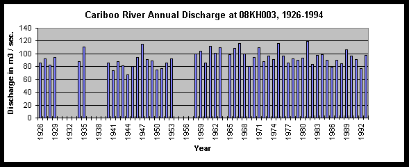
The Water Survey of Canada operates a gauging station (no. 08KH003) on the Cariboo River, just below Kangaroo Creek – located very near the downstream extent of the study area. A long period of record exists for this station and data are available from 1926 to 1994. The location of the station is indicated on Figure 1. The gauging station measures the discharge from the entire Cariboo watershed, or 3 260 km2. The mean annual runoff at station 08KH003 (Cariboo River below Kangaroo Creek) for the 56 years of record is 93.26 m3s-1 (902 mm). The annual runoff shows relative consistency, ranging from a minimum of 76.79 m3s-1 to a maximum of 119.21 m3s-1, with a standard deviation of 10.73 m3s-1.
Figure 2. Cariboo River discharge for complete years of record in m3/sec
The annual hydrograph is snowmelt dominated, with peak discharge most often occurring in June (see Figure 3). The hydrograph then descends slowly through the autumn as precipitation begins to fall as snow. Minimum flow occurs in February or March, just prior to the initiation of spring snowmelt and freshet. At peak flow in June the monthly mean is 270.66 m3s-1 as compared to the minimum mean of 19.53 m3s-1 in March. Similarly, intra-monthly flows can vary substantially from year to year. Flows in March, for instance, have a mean of 19.53 m3s-1 and a standard deviation of 8.68 m3s-1. Appendix B contains mean monthly discharge figures for the full length of the record at the hydrological station. Table 2 summarizes these data.
Figure 3. Mean annual hydrograph for the Cariboo River below Kangaroo Creek.
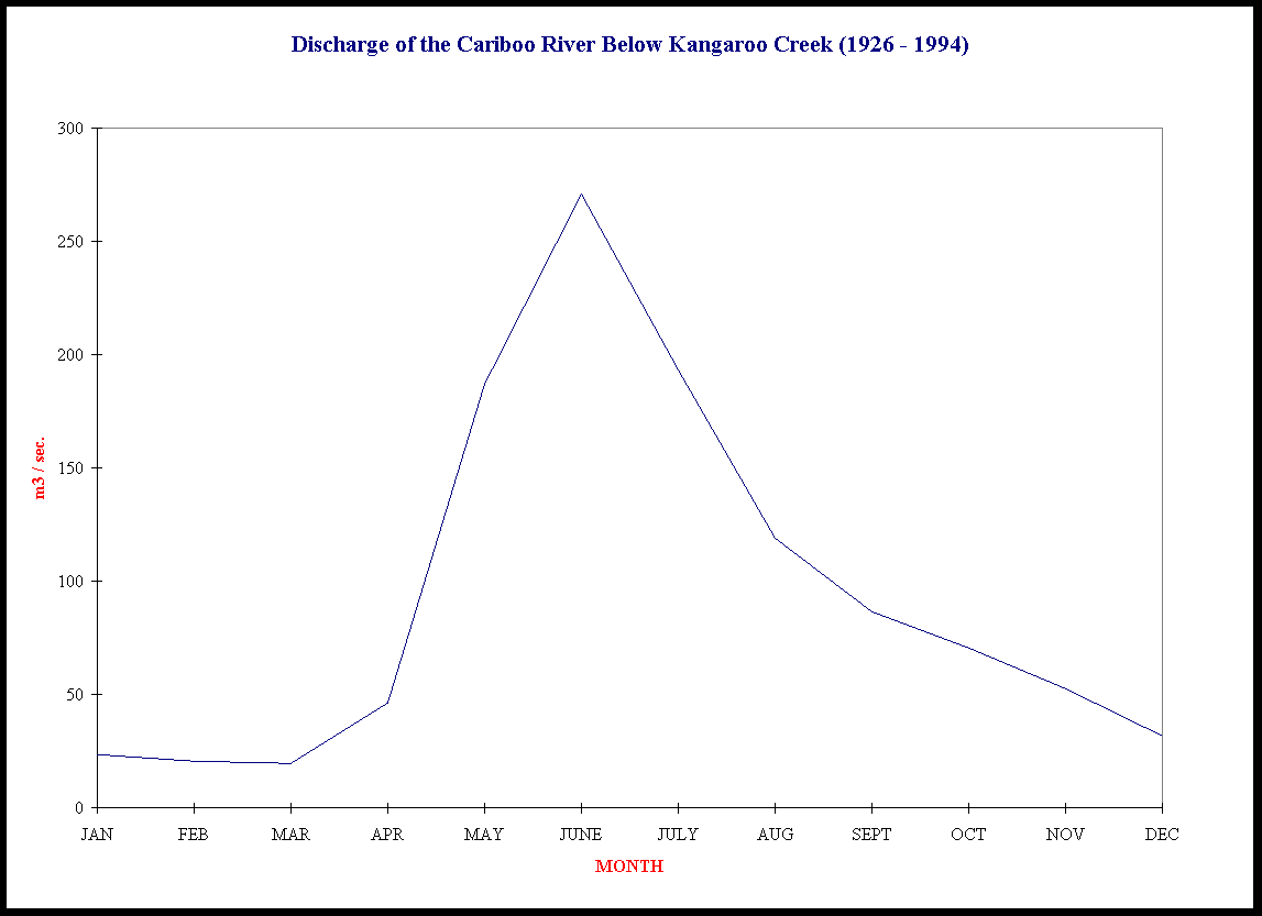
Table 2. Monthly discharge of the Cariboo River at station 08KH003 in m3s1 1926-1994.
|
|
|
|
|
|
|
|
|
Monthly Discharge |
|
|
|
Mean |
Minimum |
Maximum |
Standard Deviation |
|
|
|
|
|
|
|
|
|
January |
|
23.42 |
12.4 |
63.1 |
7.97 |
|
|
February |
|
20.22 |
8.4 |
58.6 |
8.67 |
|
|
March |
|
19.53 |
4.67 |
57.6 |
8.68 |
|
|
April |
|
45.98 |
11 |
126 |
23.34 |
|
|
May |
|
186.99 |
97.2 |
319 |
51.47 |
|
|
June |
|
270.66 |
171 |
428 |
56.9 |
|
|
July |
|
193.37 |
111 |
356 |
51.64 |
|
|
August |
|
118.97 |
74.9 |
223 |
29.7 |
|
|
September |
|
86.56 |
50.3 |
168 |
26.66 |
|
|
October |
|
70.15 |
23.9 |
137 |
25.15 |
|
|
November |
|
52.36 |
18 |
92.2 |
17.96 |
|
|
December |
|
31.66 |
16.3 |
68.4 |
10.68 |
|
|
|
|
|
|
|
|
|
Totals |
|
1119.87 |
599.07 |
2096.9 |
318.82 |
|
|
|
|
|
|
|
|
- MINING
The Cariboo River watershed has a long history of mining exploration and exploitation. Beginning with the gold rush of the 1860’s when placer-type gold deposits were discovered in the Kiethley Creek watershed, mines have had a continual presence in the Cariboo study area. The amount of gold historically produced from the Cariboo study area watersheds is considerable. Between 1874 and 1945, almost 2 million grams (64 100 ounces) of gold were produced in the Cariboo, Cunningham, Harveys, Keithley and Spanish watersheds. Kiethley Creek alone produced more than 1 millions grams (35 000 ounces) of gold. Almost all of the gold was extracted using placer mining methods.
Modern placer mines operate a "closed circuit" water system. During the freshet, water is extracted from a creek or river and directed into a headpond. In the course of the season, the water is then used in the sluice and deposited into a settling pond. From here, it is re-cycled into the sluice and back to the pond. Occasionally, the system requires recharging from the creek or river. Under the current licensing approvals, miners are restricted to a maximum withdrawal of 14Ls-1, which gives a total potential seasonal withdrawl of about 220 000 m3. There are currently 5 mines operating in the watersheds under consideration. These sites are shown on Figure 1 and described in detail in Appendix C.
- FOREST HARVESTING
Currently, forest harvesting is the primary land-use activity in the Cariboo watershed. Weldwood of Canada Ltd. is the largest licensee in the area. In the southern portion of the watershed, Ainsworth Lumber Company and Riverside Forest Products operate.
- THE CARIBOO WATERSHED ASSESSMENT PROCEDURE
- PURPOSE OF THE ANALYSIS
The purpose of the Level 1 Interior Watershed Assessment Procedure is threefold. First, it is designed to assess the sensitivity of a watershed to hydrological changes as a result of landuse change or disturbance. Second, it assists in quantifying the extent and impacts of current and historical landuse practices, and forestry in particular. Finally, it will direct future assessments for the purpose of focusing Watershed Restoration Programs.
The procedure was carried out according to its hierarchical structure, which assesses thirteen impact measurements and related anecdotal information. The data were collected from various sources. The two primary sources of relevant data were the Ministry of Forests and the Ministry of Environment. The Ministry of Environment provided the Terrain Resource Inventory Maps (TRIM) which formed the spatial and positional base for the analysis. These digital maps contained all of the landform, contour, hydrological and road information required for the analysis. They are the standard for spatial analysis in British Columbia, and are the most accurate mapping products hitherto available. The Ministry of Forests provided the digital forest cover maps which contained detailed information relating to all aspects of forestry activity. These data are used to compile watershed report cards, which assess hazard levels in four chief areas: Peak Flow, Surface Erosion, Riparian buffer, and landslide measurement. A blank data entry form is located in Appendix D.
The purpose of the Peak Flow measurements is to evaluate the potential for changes in both the timing and magnitude of maximum discharge. In a snowmelt dominated hydrological regime, such as that of the Cariboo study area, the peak flow occurs during the spring freshet as the winter snowpack melts. The H60 line, or line above which 60% of the watershed area lies, is an attempt at defining the location of the snowpack prior to the initiation of the spring freshet. Once this has been calculated, it is then possible to determine the areal extent of logging and categorize it as being either above or below the H60 line. Forest harvesting can change the shape of the natural hydrograph. When trees are removed water is no longer taken up by the vegetation, thus increasing the soil moisture content. The primary effect of this is increased peak flows, as water is no longer required by the vegetation or to recharge soil moisture. The increased soil moisture content reduced the ability of the soil to absorb water. As a result, large storm events or rapid snowmelt more often results in the overland flow of water streamward. This process is additionally facilitated by the existence of roads, which provide an additional sediment source. This process then delivers sediment to the stream. The water yield from logged areas is also increased as trees are no longer available to either intercept rain or snow, or shade the snow from direct solar radiation and wind during spring. So then, there is both more snow available for melting (ablation) and it melts faster. Taken together, the above affect the channel system by increasing sediment load and peak discharge.
Roads and especially river crossings are significant potential sources of sediment supply to the hydrological system. Roads expose soil to increased erosion by rain and snow, and can often provide pathways to streams, creeks and rivers. River crossings are of particular concern because in these cases the roads are immediately adjacent to streams, shortening the distance from the sediment source. The Surface Erosion impact indicators are consequently measures of these variables.
The third impact category is Riparian buffer. The Riparian Buffer refers to the vegetative strip which borders a waterway or body. Riparian areas often contain smaller side channels, overhanging trees and shrubs, and deliver large woody debris (LWD) to the channel. In short, they provide many of the characteristics necessary for productive fish habitat. Increased sedimentation or logging of the Riparian Buffer can destroy fish rearing and spawning sites, thus destroying a fishery value of the stream.
The increased soil moisture content sometimes associated with logging can provide additional impetus for increased occurrences of mass wasting events. The addition of relatively modest amounts of water to an already saturated slope may result in slope failure and landslides. The last impact category, Landslides, provides a measure of the number of landslides as well as an inventory of steep and therefore potentially unstable slopes (>60%).
- METHODOLOGY
- PROCEDURAL MODIFICATIONS
The Forest Practices Code Interior Watershed Assessment Procedure Guidebook defines the methodology and procedures of the Interior Watershed Assessment. Both the rationale and the hierarchy of analysis are explicitly stated. However, since its publication in 1995, data availability and the application parameters have changed. Most importantly for this assessment are the modification of the terms of reference (see section 1.0) and the delivery agency. The data from this analysis is not in any way part of the Ministry of Forests’ formal planning process. It is, rather, intended for watershed restoration purposes only. Also, the delivery agency is not the Ministry of Forests (MoF) as presumed by the guidebook. Instead, the report was commissioned by the Ministry of Environment, whose digital data delivery requirements differ significantly from those of the MoF. These two factors affected the prescribed procedure.
The Ministry of Environment’s Terrain Resource Inventory Maps (TRIM) are now available for almost the entire province. With respect to positional accuracy and landform descriptions, these maps are the highest quality available today. Consequently, rather than changing the TRIM base from the more accurate North American Datum (NAD) 1983 to NAD 27 as suggested in the guidebook, the procedure was reversed. This method has the advantages of maintaining the positional accuracy inherent in the TRIM base, while at the same time producing a series of coverages in the MELP standard form.
A related modification was the preferential use of TRIM data whenever possible. The guidebook suggests that TRIM be used to provide a base with which to augment the forest cover data (FC1). In the interest of positional accuracy and appropriate formatting, the forest cover information was selectively chosen from the FC1 data to provide information pertinent to the analysis. The positional accuracy of the TRIM base was maintained and any further data compatibility problems were minimized.
- RESULTS OF THE ASSESSMENT
This section presents the results of the application of the Interior Watershed Assessment Procedure to the Cariboo River watershed. The tabular manner in which the results are presented is intended to allow the reader to easily compare the results of individual watersheds. Of most use are the density measurements, which allow for fair comparison of individual watersheds.
An extremely useful product of the IWAP is the mapping products which are produced as an integral part of the final product. These maps facilitate intuitive comparison of watersheds and visual analysis of the many phenomena which cumulatively result in the hazard impact scores. Medium-scale maps of the study area watersheds showing roads, rivers, wetlands, lakes, slopes greater than 60%, H60 lines and the tree stand heights used in the equivalent to clearcut area (ECA) calculations are contained in Appendices F through N. With each watershed map is the completed IWAP calculation sheet. These sheets show in greater detail the measurements, indicators, scores and hazard indices in each of the four hazard analysis areas (i.e. Peak Flow, Surface Erosion, Riparian Buffer and Landslides).
The watersheds under consideration vary greatly in areal extent. Table 3 gives the area breakdown for each watershed. Of note are the relatively high elevations of the H60 lines. With the exception of Spanish Creek watershed, which is most southern, all of the lines are between 1300 and 1400 metres. Snowpack in these higher elevations is likely to be significantly higher than proximal lower elevation stations. For instance, Barkerville, which is located just outside of the northwestern boundary of the study area, receives more than 60% more precipitation than the lower elevation station at Likely.
Table 3. Areal measurements of the study area watersheds by elevation.
|
Watershed Name |
Watershed
Code |
H60 elevation (metres) |
Area below H60 line (ha) |
Area above H60 line (ha) |
Total watershed area (ha) |
|
Cunningham Crk. |
160-4661-410 |
1380 |
6 719 |
10 125 |
16 844 |
|
Harveys Creek |
160-4661-295 |
1420 |
1 567 |
2 175 |
3 742 |
|
Kiethley Creek |
160-4661-192 |
1380 |
6 147 |
8 813 |
14 960 |
|
Kimball Creek |
160-4661-432 |
1460 |
2 625 |
4 028 |
6 653 |
|
Little River |
160-4661-282 |
1420 |
13 965 |
21 396 |
35 361 |
|
Matthew River |
160-4661-492 |
1400 |
16 099 |
23 671 |
39 770 |
|
Rollie Creek |
160-4661-177 |
1340 |
2 587 |
3 794 |
6 381 |
|
Seller Creek |
160-4661-141 |
1440 |
3 498 |
5 391 |
8 889 |
|
Spanish Creek |
160-4661-107 |
1160 |
5 480 |
7 703 |
13 183 |
Table 4 summarizes the roads inventory and density calculations. These numbers are used to calculate the Peak Flow Hazard index. Road lengths for the watershed were measured digitally directly from the relevant TRIM maps. In general, these maps do not show the full extent of roads within the watershed. It is often preferred, then, to use the Forest Inventory Planning sheets. However, these maps do not have the positional accuracy of the TRIM data. Furthermore, they appear in this case to be less comprehensive than the TRIM. However, the Sediment Source Survey undertaken by Cariboo Envirotech suggested that both data sets were underestimating the length of the roads in the study area by as much as 50 percent. Consequently, the length of roads, and the resulting hazard indices, may be significantly underestimated.
The equivalent clear-cut area (ECA) is calculated to estimate the hydrological recovery of a watershed following harvesting. As such, burn areas, slides and hydro-cuts are considered clear-cuts with 0% recovery. Table 5 summarizes the ECA measurements for the Cariboo region, along with their position relative to the H60 line. Also shown are the Peak Flow Hazard indices. As well as underestimating the length of the roads, the Forest Cover data may be underestimating the extent of logging in the study area. A number of the watersheds have roads indicated on the TRIM sheets which are highly suggestive of logging activity, but which have no such activity indicated on the Forest Cover sheets (see the Northeast portion of Cunningham Creek in Appendix E, for example). This error may be a consequence of the age of the Forest Cover data (some sheets were last updated in 1992), or it may be the result of missing or inaccurate database entries.
Table 4. Road inventory and density
| |
|
|
Road above
H60 line |
Road for
entire watershed |
|
Watershed Name |
Watershed
Code |
Watershed area (ha) |
Length
(m) |
Density
(km/km2) |
Length
(m) |
Density
(km/km2) |
|
Cunningham Creek. |
160-4661-410 |
16 844 |
25 777 |
0.15 |
116556 |
0.69 |
|
Harveys Creek |
160-4661-295 |
3 742 |
3 046 |
0.08 |
22939 |
0.61 |
|
Kiethley Creek |
160-4661-192 |
14 960 |
47 722 |
0.32 |
158047 |
1.06 |
|
Kimball Creek |
160-4661-432 |
6 653 |
0 |
0.00 |
12020 |
0.18 |
|
Little River |
160-4661-282 |
35 361 |
953 |
0.00 |
117277 |
0.11 |
|
Matthew River |
160-4661-492 |
39 770 |
0 |
0.00 |
135104 |
0.34 |
|
Rollie Creek |
160-4661-177 |
6 381 |
14 354 |
0.22 |
49072 |
0.77 |
|
Seller Creek |
160-4661-141 |
8 889 |
3 838 |
0.04 |
47430 |
0.53 |
|
Spanish Creek |
160-4661-107 |
13 183 |
57 654 |
0.44 |
154097 |
1.17 |
Table 5. Peak flow index measurements and results
| |
|
Below H60 line |
Above H60 line |
Peak |
|
Watershed Name |
Watershed
Code |
Weighted ECA
(ha) |
Weighted ECA
(ha) |
flow index
|
|
Cunningham Creek. |
160-4661-410 |
497 |
51 |
0.15 |
|
Harveys Creek |
160-4661-295 |
350 |
37 |
0.18 |
|
Kiethley Creek |
160-4661-192 |
2 029 |
1 341 |
0.45 |
|
Kimball Creek |
160-4661-432 |
176 |
0 |
0.04 |
|
Little River |
160-4661-282 |
1 558 |
72 |
0.08 |
|
Matthew River |
160-4661-492 |
4 351 |
183 |
0.19 |
|
Rollie Creek |
160-4661-177 |
345 |
362 |
0.24 |
|
Seller Creek |
160-4661-141 |
815 |
70 |
0.17 |
|
Spanish Creek |
160-4661-107 |
1 440 |
1 407 |
0.45 |
The Surface Erosion index is a measure of potential sediment sources to the hydrological system, based on proximity of roads, density of road crossings and slope stability. Resource soil and landform maps were not available for the analysis, however these maps were assessed on microfiche. Except for the lowest reaches of the main channels, the soils and landforms correspond to low to medium erosion hazard classifications. Most of the textures are medium or coarse, and the landforms are generally colluvial or glaciofluvial (not of small or sand-size texture). For the purpose of the above analysis, erodible soils were considered to be all slopes of greater the 60%. This is in adherence to the guidebook (pg. 59), but given the soils and landforms it probably overestimates the erodiblity of the soils. Table 6 summarizes the Surface Erosion variables.
Impacts to the Riparian Buffer are area are assessed using several indices: the total stream length and the length of stream logged for both fish and non fish-bearing streams. As part of this current contract Carmanah is all charged with an Overview and Level I Fish Habitat Assessment of the Cariboo watershed. This assessment will estimate more accurately the extent of fish-bearing streams than the current information available. For this reason, the calculations that require this information have been excluded. The remaining Riparian Buffer variables are summarized on Table 7. Where necessary, in the absence of data on fish bearing streams, all permanent streams were considered to be fish-bearing
The Mass Wasting hazard is calculated from landslide density, the density of roads on unstable slopes, and the density of streams with banks logged on slopes greater than 60 percent. The most recent air photographs available were flown in 1992. However, Cariboo Envirotech recently undertook a Sediment Source, and reported no significant mass movement occurrences. Also, the soil and landform maps together with the drainage patterns visible on the TRIM maps point towards relatively well drained soil coverage. Given these conditions, the landslides were not inventoried as part of this study.
Finally, the Mass Wasting Hazard is given as equal to the greater of:
- the density of landslides;
- the average of the density of roads on unstable slopes and the streambanks logged on slopes greater than 60%;
- the average of the density of landslides, the density of roads on unstable slopes, and the streambanks logged on slopes greater than 60%;
Because of the relatively high density of roads on unstable soils, and streambanks logged on steep slopes, it is improbable that landslide density would affect the Mass Wasting Hazard index in any of the sub-basins. However, it should be noted that the use of the surrogate variable Slopes over 60 percent instead of the more correct unstable soils can have the effect of over-estimating the area of potentially unstable terrain. Table 8 summarizes the Mass Wasting hazard calculations.
Table 6. Roads adjacent to streams
|
Water |
Water |
Water
shed |
Roads on erodible soils |
Roads within 100m of stream |
Roads within 100m of stream on erodible soils |
Density of stream crossings |
|
shed |
shed |
area |
Length |
Density |
Length |
Density |
Length |
Density |
No. |
Density |
|
Name |
Code |
(ha) |
(m) |
(km/km2) |
(m) |
(km/km2) |
(m) |
(km/km2) |
|
(km/km2) |
|
Cunningham Creek. |
160-4661-410 |
16844 |
43218 |
0.26 |
21624 |
0.13 |
7 729 |
0.05 |
21 |
0.12 |
|
Harveys Creek |
160-4661-295 |
3 742 |
22139 |
0.59 |
3 520 |
0.09 |
3 381 |
0.09 |
3 |
0.08 |
|
Kiethley Creek |
160-4661-192 |
14960 |
73674 |
0.49 |
25320 |
0.17 |
13180 |
0.09 |
42 |
0.28 |
|
Kimball Creek |
160-4661-432 |
6 653 |
6 478 |
0.19 |
1 384 |
0.02 |
284 |
0.00 |
3 |
0.05 |
|
Little River |
160-4661-282 |
35361 |
54607 |
0.15 |
11185 |
0.03 |
4 712 |
0.01 |
19 |
0.05 |
|
Matthew River |
160-4661-492 |
39770 |
50515 |
0.13 |
10468 |
0.03 |
3 029 |
0.01 |
16 |
0.04 |
|
Rollie Creek |
160-4661-177 |
6 381 |
17032 |
0.27 |
4 631 |
0.07 |
1 976 |
0.03 |
9 |
0.14 |
|
Seller Creek |
160-4661-141 |
8 889 |
19936 |
0.45 |
2 388 |
0.03 |
1 353 |
0.02 |
6 |
0.07 |
|
Spanish Creek |
160-4661-107 |
13183 |
70193 |
0.53 |
18097 |
0.14 |
8 236 |
0.06 |
29 |
0.22 |
Table 7. Riparian buffer impacts
| |
|
|
|
Portion of |
|
Watershed |
Watershed |
Length of |
Total |
stream |
|
Name |
Code |
stream |
stream |
logged |
| |
|
logged (m) |
length (m) |
(km/km) |
| |
|
|
|
|
|
Cunningham Creek |
160-4661-410 |
3 668 |
90 192 |
0.04 |
|
Harveys Creek |
160-4661-295 |
1 615 |
20 337 |
0.08 |
|
Kiethley Creek |
160-4661-192 |
10 995 |
80 869 |
0.14 |
|
Kimball Creek |
160-4661-432 |
513 |
35 300 |
0.01 |
|
Little River |
160-4661-282 |
7 902 |
214 270 |
0.04 |
|
Matthew River |
160-4661-492 |
23 321 |
246 372 |
0.09 |
|
Rollie Creek |
160-4661-177 |
6 204 |
49 366 |
0.13 |
|
Seller Creek |
160-4661-141 |
6 759 |
93 331 |
0.07 |
|
Spanish Creek |
160-4661-107 |
7 220 |
85 517 |
0.08 |
Table 8. Mass Wasting hazard measurements
| |
|
|
Landslides |
Roads on |
Streams whose banks |
|
Watershed |
Watershed |
Watershed |
in |
Unstable |
have been logged on |
|
Name |
Code |
area |
Watershed |
Terrain |
slopes >60% |
| |
|
(ha) |
Number |
Density |
Length |
Density |
Length |
Density |
| |
|
|
|
(no./km2) |
(m) |
(km/km2) |
(m) |
(km/km2) |
|
Cunningham Creek. |
160-4661-410 |
16 844 |
0 |
0.00 |
43 218 |
0.26 |
2 784 |
0.02 |
|
Harveys Creek |
160-4661-295 |
3 742 |
0 |
0.00 |
22 139 |
0.59 |
1 615 |
0.04 |
|
Kiethley Creek |
160-4661-192 |
14 960 |
0 |
0.00 |
73 674 |
0.49 |
8 340 |
0.06 |
|
Kimball Creek |
160-4661-432 |
6 653 |
0 |
0.00 |
6 478 |
0.19 |
135 |
0.00 |
|
Little River |
160-4661-282 |
35 361 |
0 |
0.00 |
54 607 |
0.15 |
7 902 |
0.01 |
|
Matthew River |
160-4661-492 |
39 770 |
0 |
0.00 |
50 515 |
0.13 |
7 232 |
0.02 |
|
Rollie Creek |
160-4661-177 |
6 381 |
0 |
0.00 |
17 032 |
0.27 |
2 892 |
0.05 |
|
Seller Creek |
160-4661-141 |
8 889 |
0 |
0.00 |
19 936 |
0.45 |
5 173 |
0.06 |
|
Spanish Creek |
160-4661-107 |
13 183 |
0 |
0.00 |
70 193 |
0.53 |
4 193 |
0.03 |
Although forestry is the principal landuse activity in the study area, the area is also used for non-forestry related activities. Among these is mining. Mining activity in the Cariboo pre-dates the Barkerville gold rush of the late 19th century. Currently, there are five placer mines licensed in the study area. The area is also used for game hunting, and many of the roads are open to recreational use. These land uses are summarized on Table 9.
Table 10 summarizes the ownership characteristics in the Cariboo Study area. The region is almost entirely crown land. Small private holdings exist in the Cunningham, Keithley, Rollie, and Seller Creek watersheds. These holdings never exceed more than 7 percent of the watershed. Undetermined crown or private holdings are not present in the study area.
Other physical characteristics of the study area, including dominant geology, hydrologic zone, percent area with unstable slopes, DFO or MELP concerns, and glacier presence, are summarized on Table 11.
Table 9. Other land uses
|
Watershed |
Watershed |
Range use close |
Mining use
to streams? |
All-terrain vehicles |
|
Name |
Code |
to streams? |
|
close to streams? |
| |
|
(yes/no) |
(yes/no) |
(yes/no) |
|
Cunningham Creek. |
160-4661-410 |
No |
Yes |
Yes |
|
Harveys Creek |
160-4661-295 |
No |
No |
No |
|
Kiethley Creek |
160-4661-192 |
No |
Yes |
Yes |
|
Kimball Creek |
160-4661-432 |
No |
No |
No |
|
Little River |
160-4661-282 |
No |
No |
No |
|
Matthew River |
160-4661-492 |
No |
No |
No |
|
Rollie Creek |
160-4661-177 |
No |
No |
No |
|
Seller Creek |
160-4661-141 |
No |
No |
No |
|
Spanish Creek |
160-4661-107 |
No |
Yes |
Yes |
Table 10. Watershed ownership characteristics
|
Water- |
Water |
Water- |
Crown |
Private |
Indeterminate
Crown / Private |
|
shed |
shed |
shed |
land |
land |
land |
|
Name |
Code |
area (ha) |
area (ha) |
% |
area (ha) |
% |
area (ha) |
% |
|
Cunningham Creek |
160-4661-410 |
16844.0 |
16784.0 |
|
0 |
0 |
0 |
0 |
|
Harveys Creek |
160-4661-295 |
3742.3 |
3742 |
|
0 |
0 |
0 |
0 |
|
Kiethley Creek |
160-4661-192 |
14959.5 |
14872 |
|
44 |
1 |
0 |
0 |
|
Kimball Creek |
160-4661-432 |
6653.1 |
653 |
|
0 |
0 |
0 |
0 |
|
Little River |
160-4661-282 |
35361.0 |
35339 |
|
00 |
0 |
0 |
0 |
|
Matthew River |
160-4661-492 |
39769.7 |
39137 |
|
0 |
0 |
0 |
0 |
|
Rollie Creek |
160-4661-177 |
6380.8 |
6320 |
|
0 |
0 |
0 |
0 |
|
Seller Creek |
160-4661-141 |
8889.1 |
1331 |
|
0 |
0 |
0 |
0 |
|
Spanish Creek |
160-4661-107 |
13161.0 |
9956 |
|
2 |
0 |
0 |
0 |
Table 11. Physical characteristics by watershed
| |
|
|
Area with |
Do DFO |
Hydro- |
Dominant |
Are there |
|
Water- |
Watershed |
Watershed |
unstable |
and/or |
logical |
bedrock |
any |
|
shed |
Code |
area |
slope |
MELP |
zone? |
geology |
glaciers? |
|
name |
|
(ha) |
(%) |
have any |
|
|
(yes/no) |
| |
|
|
|
concerns? |
|
|
|
|
Cunningham Creek |
160-4661-410 |
16844.0 |
24.1 |
No |
West Cariboo
Mountians |
5a |
No |
|
Harveys Creek |
160-4661-295 |
3742.3 |
26.1 |
No |
West Cariboo
Mountians |
5a |
No |
|
Kiethley Creek |
160-4661-192 |
14959.5 |
12.6 |
No |
West Cariboo
Mountians |
5a |
No |
|
Kimball Creek |
160-4661-432 |
6653.1 |
35.2 |
No |
West Cariboo
Mountians |
5a |
No |
|
Little River |
160-4661-282 |
35361.0 |
28.4 |
No |
West Cariboo
Mountians |
5a |
No |
|
Matthew River |
160-4661-492 |
39769.7 |
38.6 |
No |
West Cariboo
Mountians |
5a |
Yes |
|
Rollie Creek |
160-4661-177 |
6380.8 |
9.6 |
No |
West Cariboo
Mountians |
5a |
No |
|
Seller Creek |
160-4661-141 |
8889.1 |
20.2 |
No |
West Cariboo
Mountians |
5a |
No |
|
Spanish Creek |
160-4661-107 |
13161.0 |
15.7 |
No |
West Cariboo
Mountians |
5a |
No |
The results of the Watershed Assessment Procedure are summarized on the watershed report card, shown on Table 12. The index scores represent the overall hazard rating calculated from the above measurements and calculations. These numbers can be generally interpreted as follows: hazard indices of less than 0.5 are of little concern, 0.5 to 0.7 are of moderate concern, while values greater than 0.7 are cause for significant concern. These hazard ratings are only coarse approximations by themselves, since the impact categories are inter-related. The results must be interpreted in the context of the individual watersheds, and in relation to each other.
Table 12. Watershed Report Card.
|
Watershed Name |
Watershed
Code |
Peak Flow |
Surface Erosion |
Riparian Buffer |
Mass Wasting |
|
Cunningham Creek |
160-4661-410 |
0.15 |
0.37 |
0.14 |
0.38 |
|
Harveys Creek |
160-4661-295 |
0.18 |
0.54 |
0.26 |
0.57 |
|
Kiethley Creek |
160-4661-192 |
0.45 |
0.56 |
0.45 |
0.59 |
|
Kimball Creek |
160-4661-432 |
0.04 |
0.13 |
0.05 |
0.17 |
|
Little River |
160-4661-282 |
0.08 |
0.21 |
0.12 |
0.27 |
|
Matthew River |
160-4661-492 |
0.19 |
0.18 |
0.32 |
0.24 |
|
Rollie Creek |
160-4661-177 |
0.24 |
0.39 |
0.42 |
0.44 |
|
Seller Creek |
160-4661-141 |
0.17 |
0.31 |
0.24 |
0.42 |
|
Spanish Creek |
160-4661-107 |
0.45 |
0.60 |
0.28 |
0.55 |
- INTERPRETATION OF THE RESULTS
Alone, the hazard impact scores provide a gross indication of potential hydrological impacts. The purpose of this section is to interpret the numbers within the context of data quality, the individual watersheds, and the inter-relationship of the hazard indices. Based on these interpretations, recommendations are made with the goal of watershed restoration activities in mind.
There are a few data quality concerns which should be restated at this time, since they affect a number of the hazard indices calculated. The Mass Wasting hazard is in many cases driven by the high density of roads on unstable slopes. The use of the surrogate variable slopes greater than 60 percent for unstable slopes may be exaggerating the calculated score. However, the serious underestimation of the length of roads in the watershed may cause the mass wasting to be underestimated. Similarly, the Surface Erosion and Peak Flow scores may also be underestimated. Cases where this underestimation may affect the hazard indices will be noted.
- CUNNINGHAM CREEK (Appendix E)
The calculation sheet for Cunningham Creek does not indicate any significant areas of concern. However, there are a few data quality concerns beyond those stated above: the TRIM sheets indicate significant road-building in the northwest area of the drainage basin. This development is highly suggestive of logging activity, although none is indicated in the Forest Cover sheets. Furthermore, at least a portion of this development is located above the H60 line, meaning that the ECA calculations could be seriously underestimated. To summarize, the Peak Flow index may be underestimated, but is still probably low enough to be of little concern. The Surface Erosion index may also be underestimated, but is similarly probably of little concern.
Table 13. Cunningham Creek watershed report card
|
Watershed Name |
Watershed
Code |
Peak Flow |
Surface Erosion |
Riparian Buffer |
Mass Wasting |
|
Cunningham Creek. |
160-4661-410 |
0.15 |
0.37 |
0.14 |
0.38 |
Areas of potential concern are the presence of the placer mine in the watershed, and the potential presence of roads on unstable slopes not indicated on the TRIM sheets.
- HARVEYS CREEK (Appendix F)
Both the Surface Erosion and Mass Wasting hazard scores exceed the 0.5 threshold. These scores are driven by the high density of roads, many of which are built on slopes exceeding 60 percent. Furthermore, the Forest Cover data show logging activity in the watershed in areas where no roads are indicated on the TRIM maps. It is probable, then, that the length of roads is significantly underestimated in the watershed.
Table 14. Harveys Creek watershed report card
|
Watershed Name |
Watershed
Code |
Peak Flow |
Surface Erosion |
Riparian Buffer |
Mass Wasting |
|
Harveys Creek |
160-4661-295 |
0.18 |
0.54 |
0.26 |
0.57 |
- KEITHLEY CREEK (Appendix G)
Both the Surface Erosion index and the Mass Wasting index scores are above 0.5, indicating probable impacts to the hydrological system. The Forest Cover maps indicate that a significant portion of the watershed has had trees removed, although the majority of this activity is below the H60 line.
Table 15. Keithley Creek watershed report card
|
Watershed Name |
Watershed
Code |
Peak Flow |
Surface Erosion |
Riparian Buffer |
Mass Wasting |
|
Kiethley Creek |
160-4661-192 |
0.45 |
0.56 |
0.45 |
0.59 |
The high score in the Peak Flow hazard index is a consequence of the high equivalent clearcut area (ECA). Some of this activity is likely due to logging, but there are also two placer mines in the watershed. These mines are significant potential sources of sediment, and the hazard indices may underestimate the impacts on the hydrological system. The high score in the Mass Wasting category is largely due to the density of roads on unstable slopes. For this reason, the index may be overestimating the potential impacts. However, since the hazard score is 1.0 (a ceiling value) it is difficult to estimate by how much.
- KIMBALL CREEK (Appendix H)
The hazard indices for Kimball Creek indicate little cause for concern. The scores are all low, and there is no evidence to suggest that they are misleading in any way. What little development there is in the watershed is concentrated in the lower reaches of Kimball Creek, and is nearly entirely below the H60 line.
Table 16. Kimball Creek watershed report card
|
Watershed Name |
Watershed
Code |
Peak Flow |
Surface Erosion |
Riparian Buffer |
Mass Wasting |
|
Kimball Creek |
160-4661-432 |
0.04 |
0.13 |
0.05 |
0.17 |
- LITTLE RIVER (Appendix I )
The hazard indices for the Little indicate no immediate cause for concern. However, these scores may not be representative of the impacts occurring in the watershed: despite the fact that there is significant development along the mainstem of the Little River, because of the size of the watershed and the fact that there is no development in the sub-basins, the road density and ECA scores are low. The potential for impacts to the Little River is significant, and should not be disregarded on the basis of the hazard indices.
Table 17. Little River watershed report card
|
Watershed Name |
Watershed
Code |
Peak Flow |
Surface Erosion |
Riparian Buffer |
Mass Wasting |
|
Little River |
160-4661-282 |
0.08 |
0.21 |
0.12 |
0.27 |
- MATTHEW RIVER (Appendix J)
Like the Little, the Matthew River watershed hazard scores show no immediate cause for concern. However, like the Little, the scores may misrepresent the potential impacts in the watershed. Development is concentrated along the lower reaches of the mainstem, and the upper portion of the watershed acts as a buffer, decreasing the calculated densities of roads and ECA. Despite the low hazard indices, the potential exists for significant impacts in the riparian zone.
Table 18. Matthew River watershed report card
|
Watershed Name |
Watershed
Code |
Peak Flow |
Surface Erosion |
Riparian Buffer |
Mass Wasting |
|
Matthew River |
160-4661-492 |
0.19 |
0.18 |
0.32 |
0.24 |
- ROLLIE CREEK (Appendix K)
The hazard scores in Rollie Creek show no immediate causes for concern. However, both the Surface Erosion and the Mass Wasting scores may be underestimating the potential impact. These scores are both driven by the high density of roads on unstable / steep slopes. If further road-building has occurred in the watershed, there may be reason to believe impacts have occurred.
Table 19. Rollie Creek watershed report card
|
Watershed Name |
Watershed
Code |
Peak Flow |
Surface Erosion |
Riparian Buffer |
Mass Wasting |
|
Rollie Creek |
160-4661-177 |
0.24 |
0.39 |
0.42 |
0.44 |
- SELLER CREEK (Appendix L)
The hazard indices in Seller Creek are all safely low, and short of extensive road-building or logging activity, there are no immediate impact concerns.
Table 20. Seller Creek watershed report card
|
Watershed Name |
Watershed
Code |
Peak Flow |
Surface Erosion |
Riparian Buffer |
Mass Wasting |
|
Seller Creek |
160-4661-141 |
0.17 |
0.31 |
0.24 |
0.42 |
- SPANISH CREEK (Appendix M)
The Surface Erosion score and the Mass Wasting score both indicate significant potential impacts to the hydrological system. These scores are high as a consequence of extensive logging activity, high road density, significant development above the H60 line and on unstable / steep slopes. The presence of a placer mine in the watershed is no doubt contributing to the potential for impacts. Although the Peak Flow index is technically low, if any roads exist in the watershed which are not shown on the TRIM sheets the score would likely increase to the point where concern should be registered.
Table 21. Spanish Creek watershed report card
|
Watershed Name |
Watershed
Code |
Peak Flow |
Surface Erosion |
Riparian Buffer |
Mass Wasting |
|
Spanish Creek |
160-4661-107 |
0.45 |
0.60 |
0.28 |
0.55 |
- CONCLUSIONS
-
SUMMARY OF RESULTS AND RECOMMENDATIONS
This Watershed Assessment Procedure indicates that there are potentially significant impacts in the Cariboo River study area. These impacts are a consequence of logging and mining activity, road-building, and the ruggedness of the topography. Table 22 summarizes the primary and secondary concerns in the Cariboo study area, as outlined in the previous section. Table 23 summarizes the recommendations for future actions based on these concerns.
Table 22. Summary of Results
|
Watershed Name |
Watershed
Code |
Primary
Concerns |
Secondary
Concerns |
|
Cunningham Creek |
160-4661-410 |
None |
Density of roads on steep slopes |
|
Harveys Creek |
160-4661-295 |
Density of roads on steep slopes |
Roads within 100 m of streams |
|
Kiethley Creek |
160-4661-192 |
Density of roads on steep slopes and
Roads within 100 m of streams |
Peak Flow due to logging and mining activity |
|
Kimball Creek |
160-4661-432 |
None |
None |
|
Little River |
160-4661-282 |
Possible depletion of the Riparian Buffer |
Surface Erosion along the mainstem |
|
Matthew River |
160-4661-492 |
Possible depletion of the Riparian Buffer |
Peak flow due to extensive logging along the mainstem |
|
Rollie Creek |
160-4661-177 |
Possible road density |
None |
|
Seller Creek |
160-4661-141 |
None |
None |
|
Spanish Creek |
160-4661-107 |
Density of roads on steep slopes and
High Peak Flow index |
Total Road density and road density within 100 m of streams |
Most of the watersheds assessed in this analysis proved to contain potential significant hydrological concerns. As such, six of the nine watersheds are eligible for Level 2 assessments (Channel Assessment Procedure). As a watershed assessment and inventory project, this analysis has shown that forest harvesting and associated activities, such as road building, have potentially affected the hydrological regimes of the nine watersheds included in this study.
The application of the Channel Assessment Procedure (CAP) to selected watersheds within the study area would further define the location and magnitude of the hydrological impacts. Following this, restoration prescriptions may be appropriate. The decision to apply the CAP should be dependent on both the values of the stream and its prospects for restoration.
It is recommended that Keithley Creek specifically be removed from CAP eligibility. The combination of mining and forestry impacts in the watershed are sufficiently severe as to render restoration uneconomical and, likely, unsuccessful. Table 23 summarizes the recommendations.
Table 23. Summary of Recommendations
|
Watershed Name |
Watershed
Code |
Initial
Recommendations |
|
Cunningham Creek |
160-4661-410 |
None |
|
Harveys Creek |
160-4661-295 |
Limit further road-building; Undertake Channel Assessment Procedure |
|
Kiethley Creek |
160-4661-192 |
Encourage forest cover regeneration |
|
Kimball Creek |
160-4661-432 |
None |
|
Little River |
160-4661-282 |
Riparian Assessment andCAP |
|
Matthew River |
160-4661-492 |
Riparian Assessment and CAP |
|
Rollie Creek |
160-4661-177 |
Determine extent of road-building. CAP and Riparian Assessment if road-building is extensive. |
|
Seller Creek |
160-4661-141 |
None |
|
Spanish Creek |
160-4661-107 |
CAP |
- REFERENCES
Berezay, Gordon. 1996. Personal communication. Cariboo EnviroTech, Likely, B.C.
Carmanah Research Ltd. 1997. Cariboo River Stream and Fish Habitat Assessment. Prepared for the Ministry of Environment, Lands and Parks, Cariboo Region, Williams Lake, B.C. 109pp.
Lord, T.M. 1984. Soils of the Horsefly Area, British Columbia. Land Resource Institute, Vancouver, B.C. 108pp, 2 maps.
Holland, S.S. 1986. Placer Gold Production of British Columbia. British Columbia Ministry of Energy, Mines and Petroleum Resources. Bulletin 28. 89pp. (reprinted)
Struik, L.C. 1988. Structural Geology of the Cariboo Gold Mining District, East-central British Columbia. Geological Survey of Canada, Memior 421. 100 pp, 4 maps.
Forest Practices Code of British Columbia. 1995. Interior Watershed Assessment Procedure Guidebook (IWAP). Province of British Columbia. 82pp.
Tipper, H.W. 1971a. Multiple Glaciations in Central British Columbia. Canadian Journal of Earth Sciences, 8: 743-752.
Tipper, H.W. 1971b. Glacial Geomorphology and Pleistocene History of Central British Columbia. Geological Survey of Canada, Bulletin 196.