|
Recreational Fishery
Stock Assessment
1998 Final Report
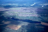
PHOTO 1. Air Photo of La Salle Lake West,
July 2000
Click image to view 72K
JPG |
|
|
|
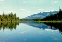
PHOTO 2. La Salle Lake West
Click image to view 40K JPG |
|
|
|
| |
TABLE 1. Physical Attributes of
La Salle Lake (West)*
| Water surface area |
120,000 sq. m |
| Area above 6 m contour |
113,000 sq. m |
| Shoreline perimeter |
2,300 m |
| Maximum depth |
7.6 m |
| Filterable residue (T.D.S.) |
109 mg/l |
| Lake drainage area |
1.4 sq. km |
| Volume |
337,000 cu. m |
| Mean depth |
2.8 m |
| Secchi disk |
2.5 m |
| Elevation |
878 m |
* from Westcott, 1987
|
|
Introduction
This report presents the results of a stock assessment
of La Salle Lake (West), completed by Ted Zimmerman and
Don Cadden on May 20, 1998. La Salle Lake (West) is a small,
oligotrophic 12 ha lake (Table 1) located just west of La
Salle Lake (East), and approximately 48 km west of McBride
(Figure 1). Both lakes are easily
accessible from Highway 16 and receive moderate use by the
angling public in the Robson Valley area. La Salle Lake
(East) was assessed in 1998, the results of this survey
can be viewed by clicking here.
The Ministry of Environment conducted a reconnaissance
survey of La Salle Lake (West) in 1987 (Westcott),
and concluded that the lake could support a viable eastern
brook trout (Salvelinus confluentus) fishery if an
annual stocking program was implemented. Based on this finding,
the lake was initially stocked with brook trout in 1988,
and then subsequently received intermittent releases of
brook trout until 1996 (Appendix
2). A follow-up stock assessment was conducted in 1992
(Van Schubert), which confirmed
that the lake was producing brook trout up to 1000g.
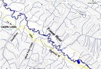
FIGURE 1. Map of La Salle Lakes
Click image to view 139K JPG |
|
|
|
To ensure that brook trout are not accidentally released
into the wild, the Ministry of Environment maintains a 'closed
system' stocking policy, which states that all lakes stocked
with brook trout must be completely isolated from the watershed
in which they are located. In 1996, occasional reports of
brook trout presence in provincial streams led fisheries
managers to conclude that some lakes were not completely
isolated. To better understand the drainage structure of
brook trout lakes in the Omineca region, each lake currently
stocked with brook trout was surveyed by Barry
in 1997.
| |
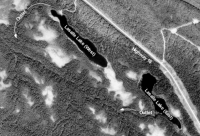
FIGURE 2. Annotated view of
La Salle Lakes
Click image to view 275K GIF |
|
|
This assessment concluded that the outlet of La Salle Lake
(West) may not be entirely closed to brook trout migration,
because its channel could become free-flowing during a high
water year (see below and Figure
2). It was recommended that the lake's outlet be examined
during the spring freshet of the following year to further
assess the risk associated with stocking brook trout into
La Salle Lake (West). Therefore, the objectives of the 1998
assessment were to :
-
Assess the current status of brook trout in La Salle
Lake (West);
-
Examine the lake's outlet to assess the risk of
brook trout escapement and;
-
Adjust or eliminate the brook trout stocking program,
if required.

| |
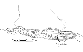
FIGURE 3. La Salle Lake (West) bathymetric map,
showing 1998 net set location
Click image to view 40K GIF |
|
Methods
An experimental, 91.2m sinking monofilament gill net was
set in La Salle Lake (West) on May 20,1998 according to
the methods described in "Fish Collection Methods and
Standards" (Resource Inventory Committee,
1997). The net was deployed May 19 at 12:20 PM and retrieved
on May 20 at 9:10 AM, for a total soak time of 20 hours,
50 minutes. The net was set in a NE-SW direction from the
west shore, approximately 670 m SSE of the Forest Recreation
Site boat launch (Figure 3).
The net was placed across depths ranging from the surface
(near shore) to approximately 6.0 m.
All trout captured were sampled for fork
length, weight,sex, and maturity. Fin rays were taken
from all brook trout, however they were not sent for age
analysis (see below).
Approximately 200m of the lake's outlet was surveyed by
foot on May 20, and the entire drainage was briefly surveyed
by helicopter on June 1, 1998, as part of a separate project.
The outlet was examined for flow and channel characteristics.
| |
TABLE 2. Mean length, weight, and condition
of brook trout sampled in La Salle Lake West,
May 20, 1998
| Attribute |
Mean |
Range |
SD |
| Length (mm) |
389 |
349-421 |
22 |
| Weight (g) |
889 |
550-1360 |
186 |
| Condition |
1.49 |
1.26-1.82 |
0.146 |
|
|
Results
CATCH SUMMARY
The net catch yielded 21 eastern brook
trout (EB) and 8 lake chub (LKC), for a catch
per unit effort of 1.0 EB per net-hour. No juvenile fish
were captured. 5 female and 11 male fish were identified,
while the remaining 5 were classified as "unknown."
The gonads of 6 of the male fish were difficult to assess
as they were rated as "immature" or "maturing,"
and their assigned gender may be in error. See Appendix
1 for individual brook trout sample data.
ANALYSIS
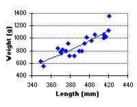 FIGURE 4. Length vs. weight of brook trout
sampled in La Salle Lake West, May 20, 1998
FIGURE 4. Length vs. weight of brook trout
sampled in La Salle Lake West, May 20, 1998
Click image to view 5K GIF |
|
|
Condition
The weight of La Salle Lake (West) brook trout increased
according the equation W = 3x10⁻⁶ x L3.2923
(R2=0.79), where W = weight in grams and L =
length in mm (Figure 4). There
were no anomolies noted amongst the fish sampled, and in
general the fish appeared healthy for their respective size.
| |
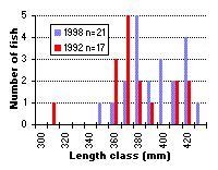 FIGURE 5. Length frequency distribution of
brook trout in La Salle Lake West, comparing 1992
and 1998 results.
FIGURE 5. Length frequency distribution of
brook trout in La Salle Lake West, comparing 1992
and 1998 results.
Click image to view
5K GIF
|
|
Size Distribution
The length-frequency distribution of brook trout captured
in 1998 was similar to that reported in 1992, with the majority
of the population falling in the 350 to 430 mm size categories
(Figure 5). The 1992 sample
appears to exhibit a bimodal distribution, with no fish
represented in the 400 mm category; these two groups may
have represented the 1987 and 1988 cohorts. In 1998 the
distributions were less distinct, and should represent the
1992, 1993 and 1995 cohorts based on the stocking history
of La Salle Lake (West) (Appendix
2).
Discussion and Management Recommendations
While the growth and condition of brook trout in La Salle
Lake (West) appears to be similar to that observed in 1992
(Figure 6), and is likely sufficient
to support a recreational fishery, our investigation of
the lake's outlet revealed that there is indeed a potential
risk of brook trout escapement.
| |
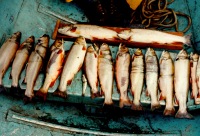 PHOTO 3. La Salle Lake (West) brook trout,
captured in 1992
PHOTO 3. La Salle Lake (West) brook trout,
captured in 1992
Click image to view 93K JPG |
|
Our examination of the lake's outlet (Figure
7) by air on June 1 revealed that the outlet channel
loses its definition within a few hundred metres of the
lake, perhaps flowing sub-surface before entering the Fraser
River (see Figure 2). However,
during a higher-than-normal spring freshet, the flow from
the lake's outlet may breach any barriers that presently
exist, resulting in brook trout escapement into the Fraser
River. This occurred in 1997 at the outlet of Barton Lake
(Barry, 1997), a finding which demonstrated
the risk of brook trout escapement in seemingly 'closed'
systems.
Given this potential risk, it was decided that the Ministry
would cease stocking the lake with brook trout, commencing
immediately. The age and growth analysis that normally accompanies
a stock assessment was not performed in this analysis, since
the cessation of stocking in La Salle Lake (West) will result
in the elimination of the remaining brook trout, either
through angling or from natural mortality. Any statistics
that would have been obtained would therefore not have been
used for the management of the fishery.
| |
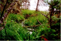 PHOTO 4. La Salle Lake (West) outlet, 1997
Click image to view 101K JPG |
|
The Robson Valley lacks a variety of recreational lake
angling opportunities due to the paucity of small lakes
in the district. Given the reasonable growth observed for
brook trout in La Salle Lake (West), it is likely that rainbow
trout will exhibit similar growth rates and should provide
a viable recreational fishing experience to anglers in the
district. The Ministry has therefore elected to replace
the brook trout stocking program with rainbow trout, commencing
in the spring of 1999. This stocking program will also provide
fisheries managers with valuable data by which to compare
stocking procedures in the adjacent La
Salle Lake (East).
Appendix 1.
Appendix 2.
Literature Cited
Barry, S. 1997. Channel assessment
of brook trout lakes, 1997. Omineca sub-Region. Ministry
of Environment, Lands and Parks. Prince George.
Resources Inventory Committee. 1997. Fish
Collection Methods and Standards, V. 4.0 Victoria.
Van Schubert, R. 1992. A stocking
assessment of La Salle Lake (West). Ministry of Environment,
Lands and Parks. Prince George.
Westcott, B. 1987. A reconnaissance
survey of La Salle Lake (West). Ministry of Environment,
Lands and Parks. Prince George.
For More Information:
Contact :Ted
Zimmerman
Sr. Fisheries Biologist, Omineca sub-Region
Prince George, B.C.
250-565-6852 |