
Land Designations that Contribute to Conservation in B.C.
Land designations that contribute to conservation are spatially-defined areas established through legislation or purchased for the protection of nature and cultural values, the conservation of biological diversity and ecosystem services and the management of natural resources. For example, conservation land designations include areas established as parks, areas identified to protect species at risk or cultural heritage, and areas that are identified to manage the balance of nature conservation and economic opportunities. This indicator reports on the status of land designations that are intended to contribute to conservation in British Columbia.
- Land designations that contribute to conservation are summarized in three categories: Protected Lands, Resource Exclusion Areas and Spatially Managed Areas. The three categories span a considerable range in contribution to conservation, with variation in purpose, scope and strength—with respect to intended conservation outcomes—and length of the term of the designations. NOTE: These categories are intended to be treated independently and the percentages of area designated should not be summed across categories.
- Protected Lands—covering 15.4% of British Columbia—includes all Parks & Protected Areas (15.0%) and Other Protected Lands (0.4%) with the primary purpose of the long-term conservation of nature and cultural values.
- Resource Exclusion Areas—covering 12.4% of B.C.—includes all designations that fully exclude one or two resource activities for the purpose of conservation.
- Spatially Managed Areas—currently covering 24.5% of B.C.— includes spatial designations managing development or a resource activity for the purpose of conservation—but where conservation is not the sole or primary objective—and resource activity is still allowed to occur. The designations within this category vary significantly in purpose and scope of management.
- More detail on the land designations that contribute to conservation and the three categories are provided below.
Protected Lands in British Columbia
15.4% of lands in B.C. are protected through legally established areas designated for the primary purpose of the long-term conservation of nature and cultural values.
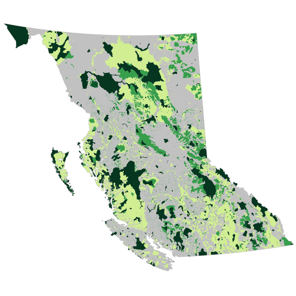
Summary of Land Designations that Contribute to Conservation in B.C. (2017)

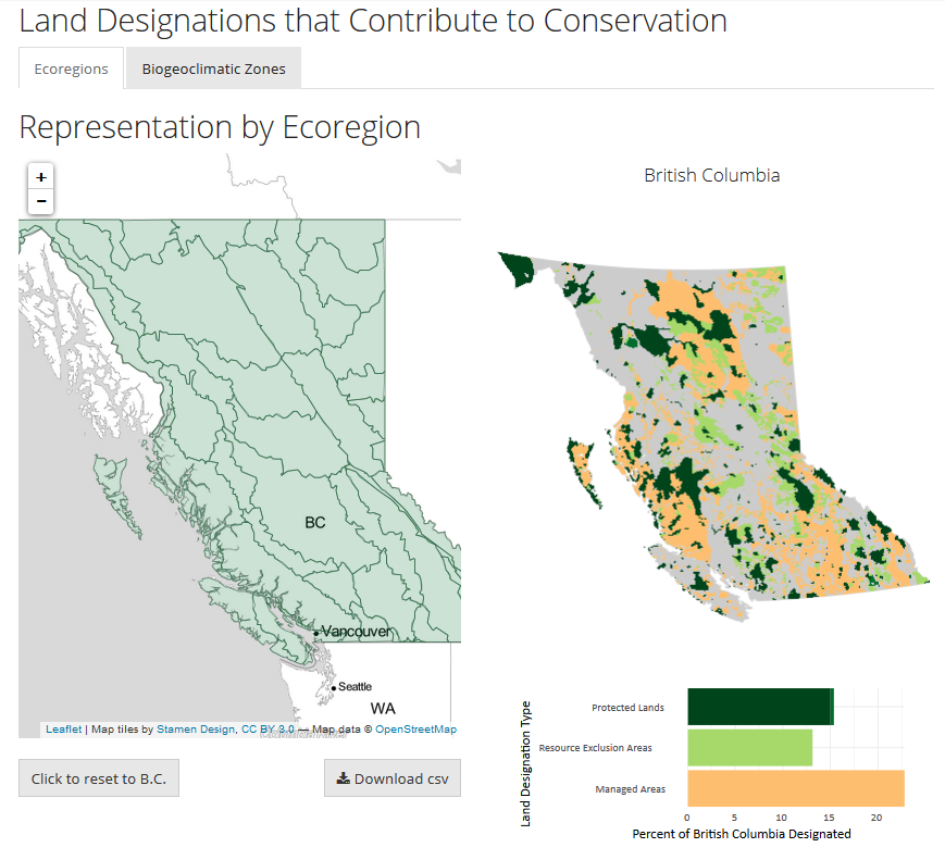
Summary of Terrestrial Ecosystem Representation within Land Designations in B.C.
- Ecosystems in British Columbia can be characterized as biogeoclimatic zones, geographic areas with similar patterns of energy flow, vegetation and soils, or as ecoregions, areas with similar climate and geologic features.
- Land designation coverage of British Columbia's 16 biogeoclimatic zones and 44 terrestrial ecoregions varies among and within the three land designation categories—Protected Lands, Resource Exclusion Areas and Spatially Managed Areas.
- Tip: Click on any ecoregion or biogeoclimatic zone below to explore land designations that contribute to conservation in that area.
 Your screen is too small to display the interactive map. Click to see the interactive visualization in full-screen.
Details of Land Designations that Contribute to Conservation
- Protected Lands (15.4%)
- Includes Parks & Protected Areas (15.0%), designations enacted in legislation with a primary purpose of the long-term conservation of nature and cultural values and that are administered by a government parks and protected areas agency (BC Parks and Parks Canada). Municipal and regional parks and water supply areas are not included in the analysis at this time.
- Includes Other Protected Lands (0.4%), such as B.C.’s non-governmental organization conservation areas or private conservation lands. These are designations and lands administered or owned by a non-governmental conservation organization and managed for the long-term conservation of wildlife habitat values.
- Other Protected Lands also includes designations enacted in legislation with a primary purpose of the long-term conservation of biodiversity and/or ecosystem services, such as National Wildlife Areas and Migratory Bird Sanctuaries, both designated by the Government of Canada, and Wildlife Management Areas designated under the provincial Wildlife Act.
- Resource Exclusion Areas (12.4%)
- Includes designations excluding one or two resource activities—such as forestry, mining or large-scale hydro-electric development—for the purpose of conservation.
- The excluded resource activity is often a primary threat to biodiversity in the established area, making the designation an important contribution to conservation.
- Some examples include designations such as no-harvest Wildlife Habitat Areas designated under the Forest and Range Practices Act, Grizzly Bear Habitat (Class 1) designated under the Land Act, and the Sea to Sky Wildland Areas designated under the Environment and Land Use Act.
- Spatially Managed Areas (24.5%)
- Includes spatial designations managing or limiting development or a resource activity—such as forestry, mining or large-scale hydro-electric development—for the purpose of conservation, or a spatially-defined management regime in place to preserve specified elements of biodiversity but where activity is still allowed to occur.
- Some examples include designations such as conditional-harvest Wildlife Habitat Areas, conditional-harvest Ungulate Winter Range, and Visual Quality Objectives—all designated under the Forest and Range Practices Act— and Important Fisheries Watersheds and other legal objectives established for the the Great Bear Rainforest under the Land Act.
The complete list of included land designations, category information, data sources, and data licence details is available in CSV format. Some designations were not included at this time due to a lack of a public, authoritative data source. These will be added to the analysis as they become available.
Methods
Overlaps among land designations have been accounted for in the analysis. While B.C. does use aspatial land management tools, this indicator only reports on legal, spatially-defined areas that contribute to conservation. The analysis presents the current status of land designations and the intended contribution to conservation—the effectiveness of land designations has not been evaluated. The Python and R code for repeating the analysis and data visualizations presented on this page is available on GitHub.
References and Other Useful Links
Data
*By accessing these datasets, you agree to the licence associated with each file, as indicated in parentheses below.
Download a printable version of this indicator (PDF, 1.3MB)
Updated November 2017
Suggested Citation: Environmental Reporting BC. 2017. Land Designations that Contribute to Conservation in B.C. State of Environment Reporting, Ministry of Environment and Climate Change Strategy, British Columbia, Canada.
