
Protected Lands & Waters in B.C.
Protected lands and waters are legally established areas set aside to conserve nature and cultural values. British Columbia's network of protected lands and waters contribute to the global and Canadian targets to set aside, by 2020, at least 17% of terrestrial areas and inland water and 10% of coastal and marine areas through networks of protected areas and other effective area-based conservation measures.1,2 This indicator reports on the trends in the establishment and status of protected lands and waters in British Columbia.
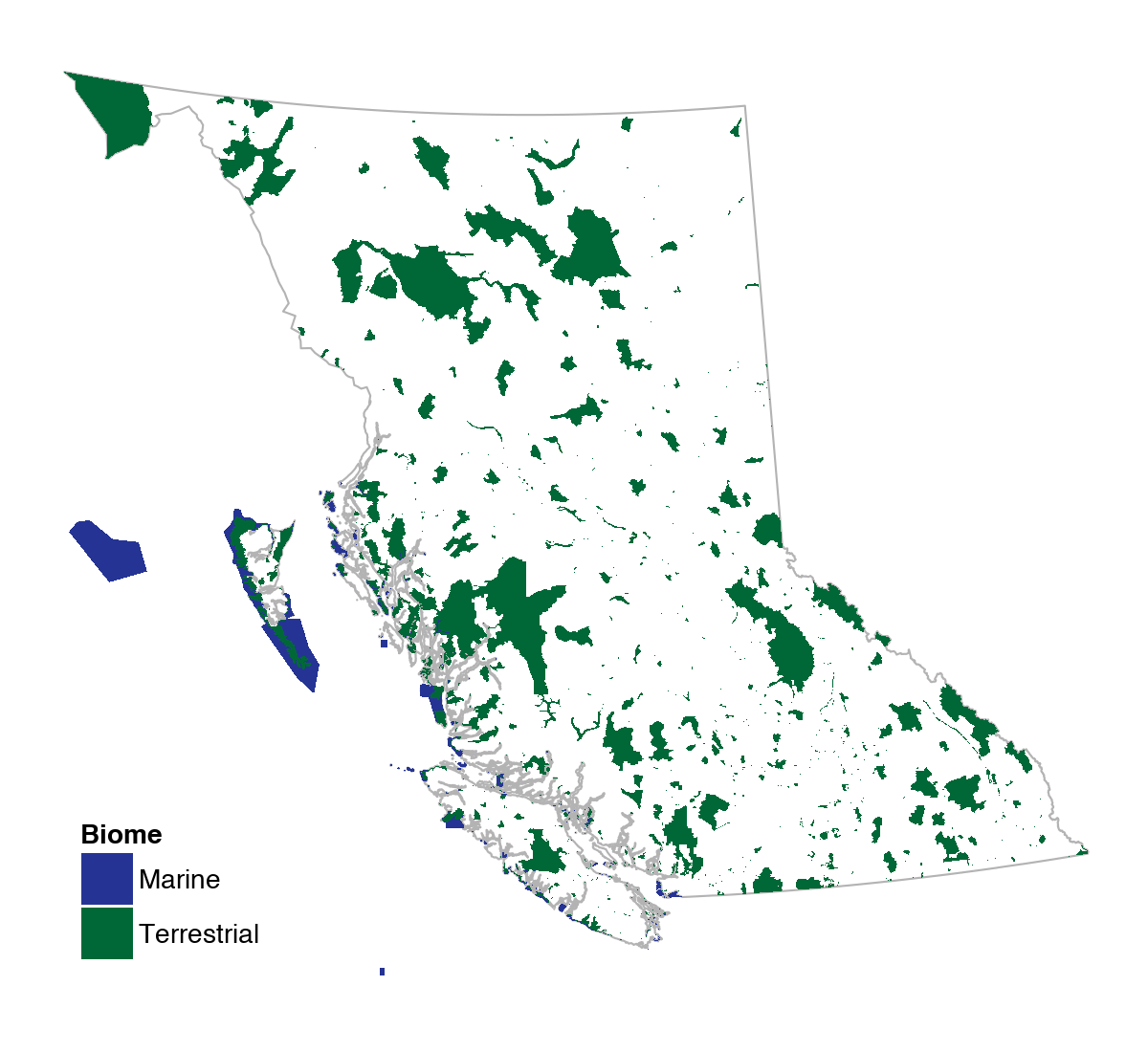
- Protected lands and waters cover 15.4% of B.C.'s land base and 3.2% of B.C.'s marine areas. In the terrestrial realm, 15.0% is in provincial and federal parks and protected areas, while the remaining 0.4% is in other provincial and federal designations such as Wildlife Management Areas and National Wildlife Areas, and private conservation lands.
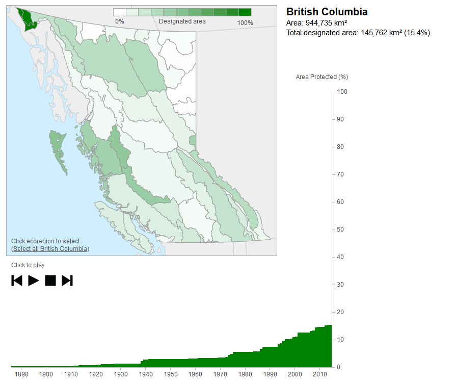
- The amount of recognized protected land in B.C. has more than doubled since the early 1990s.
- The amount of protected land and water varies across British Columbia. For example, protected areas cover over 40% of the Gwaii Haanas, Chilcotin Ranges and Eastern Hazelton Mountains regions but less than 10% of the Fraser Basin, Fraser Plateau and Thompson-Okanagan Plateau regions.
- Ecosystem representation varies within the protected areas system. For example, 30% of B.C.'s Boreal Altai Fescue Alpine habitats and 5% of Coastal Douglas-fir habitats are protected.
- Protected lands and waters, in particular BC Parks, make a major contribution to B.C.’s economy through job creation and park visitation—about 60% of British Columbians use a park every year.3,4
Map of Protected Lands & Waters in B.C. (2015)
Protected land and water designations include: all park and protected areas managed by BC Parks, all national protected area designations, such as National Parks and National Marine Conservation Areas, provincially administered conservation lands such as Wildlife Management Areas, and British Columbia's private conservation lands. Details on specific designations and legal tools are provided below.
Trends in the Protection of British Columbia's Terrestrial Ecoregions (1886-2015)
The animated map below shows how much land is protected within each of B.C.’s 44 terrestrial ecoregions, and how that has changed over time. Ecoregions are areas with similar climate and geologic features.
Tip: Press play on the animated map below to explore how the protected areas system in B.C. has changed over time. Click on any ecoregion—or tap twice on mobile devices—to see local trends and total area designated in that area.
Interpreting the Trend Information: The chart above does not reflect changes to the size of individual protected areas over time. It assumes that each protected area was it's current (2015) size when it was initally established. Only the terrestrial portion of the the Georgia-Puget Basin ecoregion is represented on this map.
 Your screen is too small to display the interactive map. Click to see the interactive visualization in full-screen.
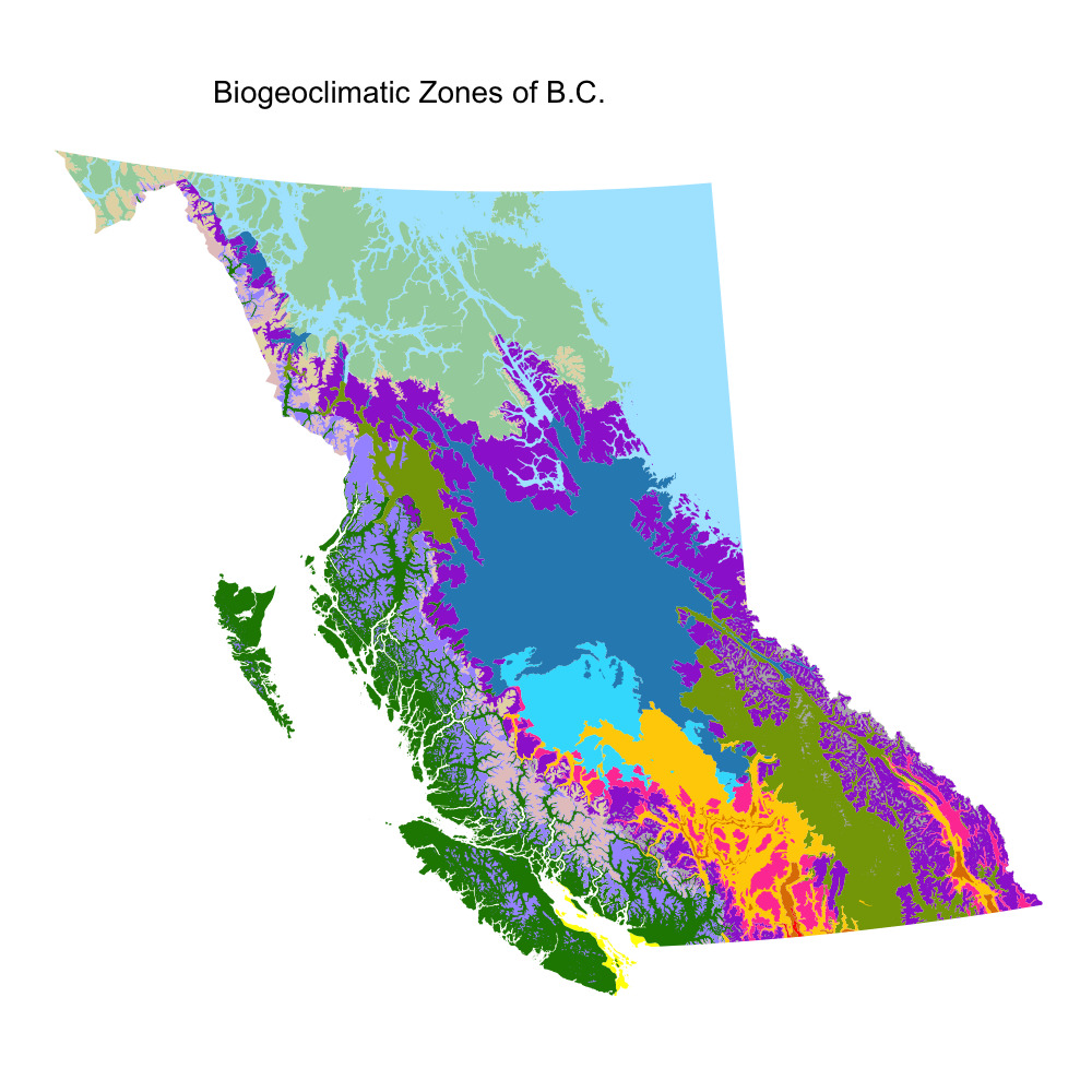
Terrestrial Ecosystem Representation within Protected Lands in B.C.
- Ecosystems in British Columbia are characterized as biogeoclimatic zones—geographic areas with similar patterns of energy flow, vegetation and soils.
- Protected lands are not evenly distributed among British Columbia's ecosystems. High elevation and mountainous areas such as the Spruce – Willow – Birch, Boreal Altai Fescue Alpine, and Interior Mountain-heather Alpine zones have more than the provincial average protected. Low elevation, warm, valley bottom areas tend to be underrepresented in the protected areas system—for example, Coastal Douglas-fir, Ponderosa Pine, and Interior Douglas-fir zones.
- There is also high spatial variation in the proportion of ecosystem protection across the province. For example, most of the 20% Coastal Western Hemlock zone that is protected occurs along the west coast of Haida Gwaii. Protected areas in the Spruce – Willow – Birch zone are more evenly distributed.

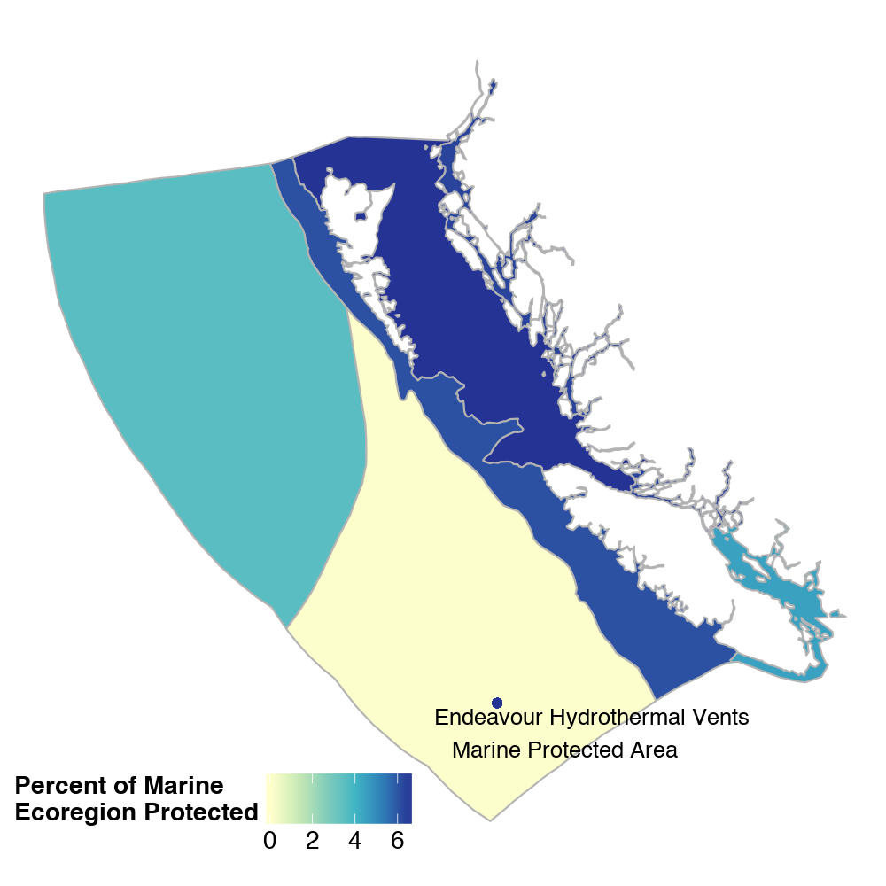
Marine Protected Areas in B.C.
- Protected areas cover 3.2% of B.C.'s coastal and marine areas.
- B.C. has 200 designated marine protected areas located in all six of the provincial marine ecoregions.
- The Endeavour Hydrothermal Vents Marine Protected Area was established in B.C. waters in 2003—the first marine protected area in Canada.

Details of Protected Land & Water Designations in B.C.
-
BC Parks (14.4% terrestrial; 0.9% marine)
- Most of the protected land and a third of the protected waters in B.C. are managed by BC Parks.
- Protected areas managed by BC Parks are governed by several pieces of legislation and fall into one of the following designations: Ecological Reserve, Provincial Park, Protected Area, Conservancy, Recreation Area.
-
National Protected Areas (0.7% terrestrial; 2.2% marine)
- The Government of Canada has established protected land and marine areas in British Columbia, for example National Parks, National Wildlife Areas, Marine Protected Areas and Migratory Bird Sanctuaries.
- These designations are governed by several pieces of federal legislation including: Canada National Parks Act, Canada National Marine Conservation Areas Act, Canada Wildlife Act, Migratory Birds Convention Act, and the Oceans Act (1996).
-
B.C. Provincial Administered Conservation Lands (0.26% terrestrial; 0.07% marine)
- Administered Conservation Lands are lands over which the Government of British Columbia has legal administrative and management authority.
- Wildlife Management Areas are Administered Conservation Lands that are designated under the provincial Wildlife Act to protect habitat for regionally, nationally or internationally significant species.
- Other types of Administered Conservation Lands are aquired by way of: Land Act section 106 Transfers of Administration, Fee Simple Acquisitions (through direct purchase, donation, or land exchange), and Lease Sites.
-
B.C. Non-Government Organization Conservation Areas (0.1% terrestrial)
- B.C. Non-Government Organization Conservation Areas, also known as private conservation lands, include Fee Simple areas, defined as ownership of the title to a legal parcel, and Registerable Interests—other conservation securements registered on title, such as conservation covenants and leases.
Note: The sum of the numbers listed above will be greater than the total provincial area reported on this page (15.4%). This is because there is some overlap among designations. For example, there are about 10,000 hectares of land that are owned by non-governmental conservation organizations, but are administered by the province. These lands are included in both categories, but the overlap is removed in the overall provincial and ecoregional analyses.
Methods
This indicator uses data from 3 sources: the 2015 Canadian Council on Ecological Areas (CCEA) shapefile database of protected areas in Canada accessed in January 2016; the provincially administered conservation lands maintained by the B.C. Ministry of Forests, Lands and Natural Resource Operations, and data for privately held conservation lands, such as those owned by land trusts, or private lands protected by conservation covenants, available from the British Columbia Non-Governmental Organization Conservation Areas Database Working Group. Municipal and regional parks are not included in the analyses. The R code for repeating the analyses presented on this page is available on GitHub. Overlaps between protected areas have been accounted for in the analyses unless otherwise stated.
References and Other Useful Links
- Canadian Environmental Sustainability Indicators: Canada's Protected Areas
- Canadian Council on Ecological Areas (CCEA)
- British Columbia Non-Governmental Organization Conservation Areas Summary Report 2015-2016
- B.C. Government Conservation Lands
- 12020 Biodiversity Goals and Targets for Canada
- 2 Convention on Biological Diversity: Aichi Biodiversity Targets
- 3BC Parks Facts and Figures
- 4Canada Parks Council. 2011. Economic Impact of Canada’s National Provincial and Territorial Parks in 2009. A Technical Report prepared by The Outspan Group Inc. Amherst Island, Stella, Ontario. Available online at: http://www.parks-parcs.ca/english/cpc/economic.php
Data
*By accessing these datasets, you agree to the licence associated with each file, as indicated in parentheses below.
- Indicator Summary Data: Protected Lands and Waters in B.C.
- Canadian Council on Ecological Areas (CCEA) shapefile database of protected areas in Canada
- B.C. Government Conservation Lands
- B.C. NGO Conservation Areas Database—Fee Simple Areas
- Ecoregions - Ecoregion Ecosystem Classification of British Columbia
- Biogeoclimatic Ecosystem Classification (BEC) Map
Download a printable version of this indicator (PDF, 2.2MB)
Updated June 2016
Suggested Citation: Environmental Reporting BC. 2016. Protected Lands & Waters in B.C. State of Environment Reporting, Ministry of Environment, British Columbia, Canada.
