Last updated February 2012
Depending on the type of research you are doing you may require access to a Water Rights map(s)--or some other available spatial data--in order to view the locations of applications and licences and their points of diversion, works, appurtenant land, etc. To obtain access to spatial data, go to http://ilmbwww.gov.bc.ca/content/e-services/geobc/imapbc.
Alternatively, if you wish to view the location of PODs, works, etc., on a licence-by-licence basis, you can access the plats for each licence from the Scanned Licences Directory.
General tips on How to Use the Water Licences Query:
-
Type in search criteria in desired field (e.g. Roy Spring under Stream Name), or click on dropdown menus where available and select search criteria from lists (e.g. Domestic from Purpose list).
- Fields are not case sensitive.
- Fields are embedded with a wild card (e.g. typing in Roy under Stream Name will find all instances of Roy, i.e. Roy Creek, Roy Spring, Roy Brook).
-
Select the type of output/export option you want by clicking on the drop down menu. For assistance with output/export options see Help on Output/Export Options.
- Click on SUBMIT.
FIELD LEVEL HELP
Stream Name - As defined in the Water Act, "a stream includes a natural watercourse or source of water supply, whether usually containing water or not, groundwater, and a lake, river, creek, spring, ravine, swamp and gulch."
- Field is not case sensitive (e.g. Mission, MISSION or mission all display the same results).
- If the exact stream name is unknown, enter the first few characters. All streams which begin with those characters will be displayed. For example, entering "Miss" displays "Mission Creek", "Missioner Creek", "Mission Ponds", "Mission Slough", "Missouri Gulch", etc.
- Duplicate stream names may occur throughout the province; note the District/Precinct field to confirm the location.
Licence No - A unique seven-character identifier, assigned for each licence to divert and use water. An Application Number is a unique number, assigned for each application for a licence to divert and use water.
Description of licence/application type:
-
Cnnnnnn - Conditional Licence ("licence that authorizes the construction of works or the diversion and use of water before the issue of a final licence" Water Act - 1996). Example: Conditional Licence - C031755.
-
Fnnnnnn - Final Licence ("licence that authorizes the diversion and use of water, and does not authorize the construction of additional works or an extension of the use of water" Water Act - 1996). Example: Final Licence - F014044.
-
Znnnnnn - Application Number with a prefix of Z followed by 6 digits. This number was assigned prior to May 2010. (An application for a licence to authorize the construction of works and diversion and use of water). Example: Application - Z014044.
-
nnnnnnn - Application Number with no alpha prefix and seven digits. This number was assigned after May 2010. (An application for a licence to authorize the construction of works and diversion and use of water). Example: Application - 1014044.
Purpose - Use of water authorized by licence. For detailed descriptions of each purpose, click here: Purpose Descriptions.
A licence can have up to three purposes, but only one purpose can be selected from the drop-down list at a time. If you choose Purpose as a search criteria, note that the licences listed in your search MAY authorize other uses, e.g. irrigation or stockwatering, etc.
Quantity - Maximum quantity of water that can be diverted for the specified purpose in the licence.
- Must be a numeric entry, e.g. 500, 5000
- Must be used with a selected Purpose
- Select from available operators (default is equal to):
- = equal to
- < less than
- > greater than
- < = less than or equal to
- > = greater than or equal to
Unit - The units of measurement for the quantity of water authorized in the licence.
- MD (meters cubic / per day)
- MS (meters cubic / per second)
- MY (meters cubic / per year)
- TF (total flow) - a unit shown against non-consumptive purposes (e.g. land improvement, conservation) for which the total flow of the stream is authorized to pass through the licensed works. No water is diverted from the stream.
Qty Flag Desc - Description of the the code displayed in the Qty Flag column.
- T - Total demand for purpose, one Point of Diversion.
- M - Maximum licensed demand for purpose, multiple PODs, quantity at each POD unknown (e.g. where an "M" flag is detected, it means that the licence authorizes a maximum amount of water that can be obtained from one or more points of diversion and/or streams)
- D - Multiple PODs for purpose, quantities at each are known, PODs on different sources
- P - Multiple PODs for purpose, quantities at each are known, PODs on same source
Rediversion - Water from one stream is diverted into another stream. The second stream is used as a natural conduit to move the water closer to the place of use. The removal of the water from the second stream is a rediversion of water which originated in the first stream.
- Displayed as a Y or N value
- Where Y value is displayed, Purpose, Quantity and Units are blank.
Licensee - "Owner of any land, mine or undertaking with respect to which a licence is issued under this or a former Act" Water Act - 1996. Also referred to as "holder of a licence."
- A licence can have more than one licensee; only the primary contact/billed client is indicated in these reports
- A licensee can hold more than one licence
- Field is not case sensitive
- Licensees are entered last name first followed by first name, with no punctuation between names
- Do not include punctuation for abbreviations (e.g., LTD not LTD., CO not CO.)
- Displays all licensees which begin with the specified characters
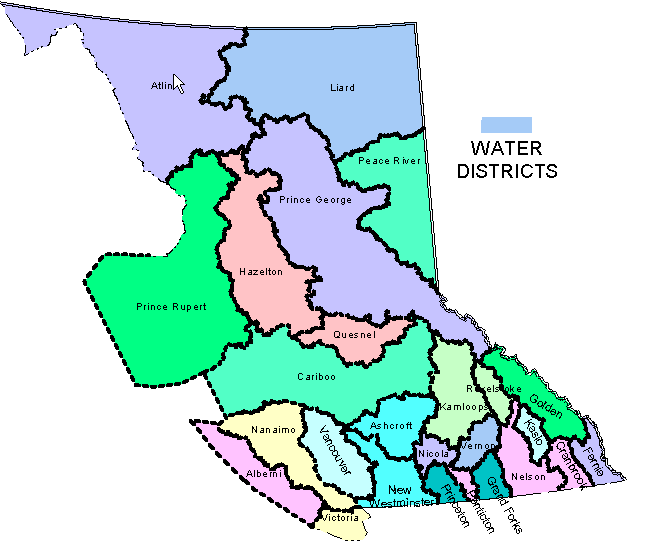
Water District/Precinct - Water District as defined under the Water Regulation "except in the definition of 'local authority', means a water district referred to in section 35 and described in Schedule C".
Precincts are jurisdictional areas within a Water District created by Water Management Branch for administrative reasons. To view a map of all Water Districts in BC, click here Map of Water Districts in BC.
- Water Districts (e.g. Alberni Water District) are displayed in the drop-down list first, in alphabetical order.
- Precincts (e.g. ALB - ALBERNI) are displayed in the drop-down list following the Water Districts. They are also listed in alphabetical order.
Points Code - Unique identifier created for Points of Diversion. This is a 5-digit code preceded by alpha characters PD (e.g., PD58512). Search results are displayed in the column Points Code. Note that Points Code is a unique identifier that is associated with digital Points of Diversion contained in the provincial TPOD_BC coverage.
- Points Code is an optional column that must be selected by typing an "X" in the box adjacent to the Points Code field before pressing the SUBMIT button.
- Licence can have one or many Points of Diversion ("the place on the natural channel of a stream where an applicant proposes, or a licensee is authorized, to divert water from the stream." Water Regulation).
- A Point of Diversion can have one or many licences (e.g., a shared intake).
- Enter PD in uppercase or lowercase, followed by 5-digit number (e.g., PD49412).
WR Map/POD - Water Rights maps are created by the Water Management Branch. These maps reconcile a Point of Diversion (POD) to a geographic location. Each Water Rights map has a unique number, located in the bottom right corner. The WR Map/POD search field is optimally used if you have in your possession a Water Rights Map.
- Licences can have one or many Points of Diversion ("the place on the natural channel of a stream where an applicant proposes, or a licensee is authorized, to divert water from the stream." Water Regulation).
- A Point of Diversion can have one or many licences (i.e. a shared intake).
Licence Status - Displays status of licence or application.
- Applications: Uncleared Appl; Active Appl.
- Licences: Current; Awaiting Sign; Pending (i.e. client does not receive a bill while licence has process status of Apportionment Pending, Cancellation Pending, Abandonment Pending, or Victoria Apportionment);
Process Status - Internal code applied to a licence or application that indicates the status of the record.
- Apportionment Pending
- Abandonment Pending
- Under Amendment
- Under Appeal
- Application-Cleared
- Cancellation Pending
- Application-Not Cleared
- Not Applicable
- Suspended
- Transfer/Appurtenancy Pending
- Victoria Amendment
- Victoria Apportionment
- Victoria Application
New licences or applications from this date forward - When selected, restricts results to Issue Date for Licences ("date on which the licence was issued") or Priority Date for Applications ("date from which the precedence of the licence is established"), starting at the date entered. Search results are displayed in the columns Priority Date or Issue Date.
- This search criteria is used for determining Priority Dates for Applications and Issue Dates for Licences, from the date entered to the present time. For example, if you enter the date 20020101 and press SUBMIT, the results page will show all applications with a priority date equal to or great than 20020101, and all licences with an Issue Date equal to or greater than 20020101.
- Only licences issued since January 1, 1992, have an Issue Date stored against them. Those licences issued prior to this date are shown simply with a zero value.
- This search criteria option was originally established for external users (e.g. Ministry of Forests) who were in possession of a Water Rights map. By using this option together with the WR map No. as search criteria, it was possible to determine whether new licences had issued or new applications had been received, on particular map, from a particular date forward.
- To use this field, enter in the format "yyyymmdd" (e.g., 19980430).
Appurtenant Land Information - Land upon which water is authorized by a licence to be used. Search results are displayed in the column Appurtenant Land.
POD Comments - Additional information relating to POD (Point of Diversion) or Rediversion.
Date Client Last Updated - Displays date that the client record was last updated. Search results are displayed in the column Last Date. Displayed in format "yyyymmdd" (e.g., 19980430).
Client No - Systems-generated number assigned for specified licensee/applicant.
- 6-digit number; first number is 0
- Leading zeroes not required (e.g., Enter 123 for Client 000123)
File No - Internal number assigned to a file that may hold one or more licences.
- 7-digit number
- Leading zeroes must be entered (e.g., Enter 0000012 not 12)
- For licences after 1982, the first digit represents the Region:
- 0 - Victoria
- 1 - Vancouver Island (Nanaimo)
- 2 - Lower Mainland (Surrey)
- 3 - Thompson (Kamloops)
- 4 - Kootenay (Nelson)
- 5 - Cariboo (Williams Lake)
- 6 - Skeena (Smithers)
- 7 - Omineca-Peace (Prince George)
- 8 - Okanagan (Penticton)
- 9 - North East
PCL No - Internal number assigned to a Permit over Crown Land (PCL) that gives "authority to, flood Crown Land or to construct, maintain or operate works on Crown Land" Water Act 1996.
- 5-digit number
- Leading zeroes not required (e.g., Enter 1234 for 01234)
|

