Overview Report
Quesnel River Study Area
Fish Habitat Assessment Procedure
Prepared for
Weldwood of Canada Ltd.
Cariboo Division, Williams Lake Operations
PO Box 4509
Williams Lake, BC, V2G 2V5
by
Roberta Pedersen, R.P. Bio., M.Sc.
Carmanah Research Ltd.
Building 4, 203 Harbour Road
Victoria, BC, V9A 3A2
Telephone: (250) 920-9900 Facsimile: (250) 920-9800
Email: fish@carmanah.com Http:\\www.carmanah.com
March 1998
Executive Summary
Carmanah Research Ltd. conducted an Overview Fish Habitat Assessment Procedure of the Quesnel River watershed. The Overview is the first step in the Fish Habitat Assessment Procedure, a process that identifies habitat restoration opportunities aimed at rejuvenating depressed fish stocks in British Columbia streams. In the Overview, streams that are third-order or larger are assessed for preliminary indications of factors limiting fish production. Fish habitat was assessed using aerial photographs, analysis of Terrain Resource Inventory Management maps, fish inventory records, and forest cover planning maps. This report describes general fish habitat conditions and provides preliminary indications of the impacts of forest harvesting on fish habitat for each sub-basin.
There is limited forest harvesting data and fish distribution, abundance and habitat utilization information for the Quesnel River watershed. Two helicopter reconnaissance flights of the study area were extremely useful in helping to assess the general condition of some of the streams and allowing better inspection of impacted areas. Several impacted areas have been identified that require further field assessment to confirm site-specific habitat rehabilitation opportunities and to assess the viability of habitat restoration work in the drainage.
The Quesnel River watershed occupies 225,751 ha in south central British Columbia. The study area is separated into nine smaller areas called buckets. The Quesnel River provides migration, rearing and spawning habitat for several salmon and non-salmon species. The mainstem has limited opportunities for fish habitat restoration activities due to the size of the river and the natural slumping of the clay walls that form the riverbanks. Possible restoration opportunities include re-vegetation of upslope areas where roads, right-of-ways and culvert installations have impacted the river. The tributaries of the Quesnel River in the lower 75 km should also be assessed for potential sediment problems.
Bucket 484 consists of five sub-basins: Dragon, Barlow, Cantin, Deacon, and Gerimi creeks. Dragon Creek, 160 m upstream of the confluence of the Quesnel and Fraser River, drains an area of 7 km2. It contains resident rainbow trout and may contain Dragon Lake whitefish, a fish species thought to be extinct. The habitat concerns in Dragon Creek include low summer flows in the lower reaches, a possible migration obstruction in reaches 1 and 2, and winter kill conditions in reach 7 due to low oxygen levels. It is recommended that Level 1 assessment work be focused on reaches 1 to 4 of Dragon Creek.
Barlow Creek, 5 km further upstream on the Quesnel River, drains an area of 70 km2 of which an estimated 90% is private land. Rainbow trout are found in several reaches including 10-Mile Lake. Fish habitat concerns on Barlow Creek include numerous roads that cross the creek and possible poor water quality in 10-Mile Lake.
Further upstream on the Quesnel River, Deacon, Cantin and Gerimi creeks require fish inventories before potential habitat concerns can be determined. These are relatively small tributaries with low flows. Fish access appears to be limited to the lower 500 m in all three tributaries. Forestry-related disturbances in these sub-basins appear to be minor.
Bucket 464a is composed of two third order sub-basins: Sardine Creek is located 39 km upstream of the Quesnel and Fraser confluence, and Towler Creek is located 11 km further upstream. Sardine Creek contains spawning areas for chinook salmon and rainbow trout. Habitat concerns include the re-channeled mainstem in Reach 1 and potential sediment and debris from roads that cross reaches 6 through 8. Towler Creek requires a fisheries inventory assessment before possible habitat concerns can be determined. A Level 1 assessment has been recommended for reach 1 of Sardine Creek.
Bucket 466 is the Morehead Creek sub-basin. It is located 85 km upstream of the Quesnel and Fraser River confluence. Chinook salmon spawn in the lower reaches of Morehead Creek and rainbow trout are found in the headwaters. Habitat concerns in the Morehead Creek sub-basin include harvested riparian areas, stream beds altered by mining activities, and possible road-related migration obstructions. A Level 1 assessment is recommended for reaches 1 through 11 of Morehead Creek.
Bucket 474 is the Maud Creek sub-basin that is located 90 km upstream of the Quesnel and Fraser River confluence. Rainbow trout reside throughout the creek and chinook salmon spawn near the Maud Creek and Quesnel River confluence. Habitat concerns on Maud Creek include road and mining related sediment generation, road related migration barriers, and harvested riparian areas. Level 1 assessment is recommended for reaches 1 and 4 of Maud Creek.
Bucket 464b is formed by three third-order sub-basins: Annette Creek is located 26 km from the outlet of Quesnel Lake; Whiffle Creek is located 32 km from the outlet; and Abbott Creek is located 36 km from the outlet. Rainbow trout reside in Annette Creek, which has no apparent fish habitat concerns related to forest harvesting. Whiffle Creek is suspected to contain rainbow trout. Harvesting to the stream bank has disturbed the stream in several reaches. Abbott Creek contains rainbow trout, burbot and bull trout. Habitat concerns on Abbott Creek include harvested riparian areas and road-related migration barriers. Level 1 assessments are recommended for reaches 4 and 7 through 11 of Whiffle Creek, and reaches 1 and 3 of Abbott Creek.
Bucket 463 is the Hazeltine Creek sub-basin that is located 14 km from the outlet of Quesnel Lake. Hazeltine Creek contains extensive spawning areas for sockeye salmon and rainbow trout. Rainbow trout are also found in the tributaries. Habitat concerns on Hazeltine Creek include seasonal low water flows, negative effects from the industrial development of Mount Polley Mine and extensive forest harvesting throughout the entire watershed. A Level 1 assessment of Hazeltine creek sub-basin is recommended.
Bucket 465 is the Spusks Creek sub-basin that is located 41 km from the outlet of Quesnel Lake. Populations of rainbow trout reside throughout Spusks Creek. Habitat concerns on Spusks Creek are road-related migration barriers, beaver-related impoundments and partially harvested riparian areas.
Bucket 469 is the Grain Creek sub-basin, located 52 km from the outlet of Quesnel Lake. Sockeye salmon spawn in the delta of Grain Creek, while rainbow trout have been found 18 km upstream from the confluence with Quesnel Lake. Habitat concerns on Grain Creek include sediment generation from forest harvesting, harvested riparian areas and bridge and road-related migration barriers. A Level 1 assessment is recommended for reaches 1 through 8.
Bucket 467 is the Wasko Creek sub-basin that is located 49 km from the outlet of Quesnel Lake. Wasko Creek has spawning grounds for sockeye and kokanee salmon. Burbot and rainbow trout also reside in the creek. Habitat concerns include low water flow in the summer, warm temperatures in lower Wasko Lake and sediment input from upslope areas on the unnamed tributary. A Level 1 assessment of reach 1 of Wasko Creek and of the unnamed tributary is recommended.
Acknowledgements
This Overview Fish Habitat Assessment Procedure report on the Quesnel River was conducted under the auspices of Forest Renewal British Columbia Watershed Restoration Program. Guidance and direction for this project was provided by Ms. K. Campbell, biologist with Weldwood of Canada Ltd., and Mr. M. Parker, Watershed Restoration Specialist, Ministry of Environment, Lands and Parks, Williams Lake.
Carmanah fisheries biologist Mr. K. Brydges and fisheries technician Ms. S. Luzzi provided constructive comments and the technical review.
Geographic Information Systems Specialists Mr. M. Neal, Mr. A. Dewey and Mr. Z. Gedalof, provided the maps for figures.
Editing and Quality Assurance: D.R. Green, Ph.D.
Table of Contents
Executive Summary *
Acknowledgements *
List of Tables *
List of Figures *
List of Photos *
Appendices *
Introduction *
Study Area *
Resource use *
Biogeoclimatic zones *
Climate *
Fish use *
Limitations of the Existing Information for the study area *
Methods *
Demarcation of the study area *
Existing information sources *
Delineation of stream reaches *
Fish use *
Overview assessment of habitat conditions *
Preliminary fish habitat assessment *
Results: Overview assessment by sub-basin *
Quesnel River Mainstem *
Sub-basin area *
Fish use *
Forestry and resource use *
Habitat condition and preliminary assessment *
Recommendations *
Bucket Number 484 *
Dragon Creek *
Barlow Creek *
Deacon Creek *
Cantin Creek *
Gerimi Creek *
Summary of recommendations *
Bucket Number 464a *
Sardine Creek *
Towler Creek *
Summary of recommendations *
Bucket Number 466 *
Morehead Creek *
Bucket Number 474 *
Maud Creek *
Bucket Number 464b *
Annette Creek *
Whiffle Creek *
Abbott Creek *
Bucket Number 463 *
Hazeltine Creek *
Bucket Number 465 *
Spusks Creek *
Bucket Number 469 *
Grain Creek *
Bucket Number 467 *
Wasko Creek *
Summary of recommendations for priority level 1 assessments
*
References *
List of Tables
Table 1. Parameters of the gauged (shaded) and estimated flow
at stations on the Quesnel River watershed (modified from Table 4, Rood and
Hamilton, 1995). *
Table 2. Preliminary assessment of environmental impacts, priority
for Level 1 work and restoration opportunities on the mainstem of the Quesnel
River. *
Table 3. Preliminary assessment of environmental impacts, priority
for Level 1 work and restoration opportunities in Dragon Creek (Bucket Area
484). *
Table 4. Preliminary assessment of environmental impacts, priority
for Level 1 work and restoration opportunities in Barlow Creek (Bucket Area
484). *
Table 5. Preliminary assessment of environmental impacts, priority
for Level 1 work and restoration opportunities in Deacon Creek (Bucket Area
484). *
Table 6. Preliminary assessment of environmental impacts, priority
for Level 1 work and restoration opportunities in Cantin Creek (Bucket Area
484). *
Table 7. Preliminary assessment of environmental impacts, priority
for Level 1 work and restoration opportunities in Gerimi Creek (Bucket Area
484). *
Table 8. Preliminary assessment of environmental impacts, priority
for Level 1 work, and restoration opportunities in Sardine Creek (Bucket Area
464a). *
Table 9. Preliminary assessment of environmental impacts, priority
for Level 1 work, and restoration opportunities in Towler Creek (Bucket Area
464a). *
Table 10. Preliminary assessment of environmental impacts, priority
for Level 1 work, and restoration opportunities in Morehead Creek (Bucket
Area 466). *
Table 11. Preliminary assessment of environmental impacts, priority
for Level 1 work and restoration opportunities on Maud Creek (Bucket Area
474). *
Table 12. Preliminary assessment of environmental impacts, priority
for Level 1 work and restoration opportunities in Whiffle Creek (Bucket Area
464b). *
Table 13. Preliminary assessment of environmental impacts, priority
for Level 1 work and restoration opportunities in Abbott Creek (Bucket Area
464b). *
Table 14. Preliminary assessment of environmental impacts, priority
for Level 1 work and restoration opportunities on Hazeltine Creek (Bucket
Area 463). *
Table 15. Preliminary assessment of environmental impacts, priority
for Level 1 work and restoration opportunities in Spusks Creek (Bucket Area
465). *
Table 16. Preliminary assessment of environmental impacts, priority
for Level 1 work and restoration opportunities in Grain Creek (Bucket Area
469). *
Table 17. Preliminary assessment of environmental impacts, priority
for Level 1 work and restoration opportunities in Wasko Creek (Bucket Area
467). *
Table 18. Summary of reaches recommended for high and moderate
priority Level 1 FHAP. *
Table 19. Level 1 FHAP Plan separated into high and moderate
priority assessments. *
List of Figures
Figure 1. The Overview Fish Habitat Assessment Procedure study
area is located in the central interior area of British Columbia (inset).
The Quesnel River watershed encompasses a drainage area of 225,750 ha. *
Figure 2. Gradient profile of the mainstem of Quesnel River
delineated into ten reaches by triangles. *
Figure 3. Fish distribution based on the Overview assessment
of Dragon, Barlow, Deacon, Cantin and Gerimi creeks (Bucket 484). *
Figure 4. Gradient profile of Dragon Creek delineated into seven
reaches by triangles. *
Figure 5. Gradient profile of Barlow Creek delineated into six
reaches by triangles. *
Figure 6. Gradient profile of Deacon Creek with six reaches
delineated by triangles. *
Figure 7. Gradient profile of Cantin Creek with five reaches
delineated by triangles. *
Figure 8. Gradient profile of Gerimi Creek with eight reaches
delineated by triangles. *
Figure 9. Fish distribution based on the Overview assessment
of Sardine and Towler creeks (Bucket 464a). *
Figure 10. Gradient profile of Sardine Creek with eight reaches
delineated by triangles. *
Figure 11. Gradient profile of Towler Creek delineating six
reaches by triangles. *
Figure 12. Fish distribution based on the Overview assessment
of Morehead Creek (Bucket 466). *
Figure 13. Gradient profile of Morehead Creek with 11 reaches
delineated by triangles. *
Figure 14. Fish distribution based on the Overview assessment
of Maud Creek (Bucket 474). *
Figure 15. Gradient profile of Maud Creek with seven reaches
delineated by triangles. *
Figure 16. Fish distribution based on the Overview assessment
of Annette and Whiffle creeks (Bucket 464b). *
Figure 17. Gradient profile of Annette Creek delineating nine
reaches by triangles. *
Figure 18. Gradient profile of Whiffle Creek with 11 reaches
delineated by triangles. *
Figure 19. Fish distribution based on the Overview assessment
of Abbott Creek (Bucket 464b). *
Figure 20. Gradient profile of Abbott Creek delineating eight
reaches by triangles. *
Figure 21. Fish distribution based on the Overview assessment
of Hazeltine Creek (Bucket 463). *
Figure 22. Gradient profile of Hazeltine Creek with eight reaches
delineated by triangles. *
Figure 23. Spusks Creek sub-basin is located on the south shore
of Quesnel Lake. Fish distribution is based on the Overview assessment. *
Figure 24. Gradient profile of Spusks Creek with eight reaches
delineated by triangles. *
Figure 25. Fish distribution based on Overview assessment of
Grain Creek (Bucket 469). *
Figure 26. Gradient profile of Grain Creek with 15 reaches delineated
by triangles. *
Figure 27. Fish distribution based on the Overview assessment
of Wasko Creek (Bucket No. 467). *
Figure 28. Gradient profile of Wasko Creek delineated into 10
reaches by triangles. *
List of Photos
Photo 1. Bank erosion caused by channeled drainage through a
poorly designed and located culvert in reach 2. *
Photo 2. Natural bank failure on Quesnel River mainstem in reach
8. Quesnel River flows from right to left in photograph. *
Photo 3. Upslope failure into Quesnel River caused by mass wasting
effluent from a first order tributary in reach 6, near the confluence with
Beaver Valley Creek. Quesnel River flows from the top to bottom of the photograph.
*
Photo 4. Dragon Creek dam is located to the left of the road,
near the outlet of Dragon Lake. Dragon Creek flows from left to right through
the photograph. *
Photo 5. Reach 1 of Morehead Creek. Historically a chinook spawning
area, this reach has been impacted by placer mining activities. The upslope
vegetation is disturbed and a truck is in the streambed. *
Photo 6. Impassable waterfalls are located immediately downstream
of a hydro dam that is under construction in reach 4 of Morehead Creek. *
Photo 7. A dam and spillway is located at the outlet of Morehead
Lake. Likely Road bisects the photograph. *
Photo 8. Chinook spawning grounds at the confluence of Maud
Creek and Quesnel River, as seen in October 1997. The Quesnel River flows
from right to left across the lower section of the photograph. *
Photo 9. Waterfalls in reach 3 of Maud Creek. Rainbow trout
are documented above and below the waterfalls. *
Photo 10. Placer mining along reach 1 of Maud Creek. The creek
flows from left to right in the photograph. *
Photo 11. A cutblock that has been designated as unsatisfactorily
restocked in reaches 1 and 3. Abbott Creek flows from left to right across
the lower section of the photograph and is also visible at the upper left
corner of the cutblock. *
Photo 12. A portion of the riparian area in reach 1 of Hazeltine
Creek has been removed. *
Photo 13. Mount Polley Mine storage and tailings area. A water
pipeline follows the roadside. The photograph shows Bootjack Lake in the distance.
*
Photo 14. A dam and clearcut riparian area in reach 2 of Bootjack
Creek near Bootjack Lake. Bootjack Creek flows from bottom to top of the photograph.
*
Photo 15. A Forest Service Recreational Site (on the lower left)
is located on the eastern end of Hen Ingram Lake. The cutblock on the southern
shoreline of the lake lacks mature trees in the riparian area. Horsefly Lake
is in the distance. *
Photo 16. Quesnel Lake joins with reach 1 of Spusks Creek forming
a basin. *
Photo 17. The cutblock in reach 5 of Grain Creek has been harvested
to the stream bank. *
Photo 18. Harvested block on lower Wasko Lake. Reach 2 is in
the foreground. *
Mylocheilus caurinus *
Appendices
Appendix A General Information on the Quesnel River Watershed Study area
Appendix B Fish Distribution Forms
Appendix C Habitat Condition Summary Forms
Appendix D Habitat Condition Summary Form codes
Introduction
At the request of Weldwood of Canada Ltd., Cariboo Division, Williams Lake Operations, Carmanah Research Ltd. conducted an Overview Fish Habitat Assessment Procedure (FHAP) of the Quesnel River watershed. This document presents the findings of the Overview FHAP for the Quesnel River watershed (Figure 1). As part of the Watershed Restoration Program, the FHAP attempts to identify opportunities and appropriate techniques to increase depressed fish stocks in streams.
This Overview used available information to provide a preliminary indication of the factors that limit fish production and fish habitat in the watershed. During this office-based activity, streams that are third order on 1:50,000 scale map sheets were reviewed. Separate reports are available for three sub-basins that were excluded from this Overview. These are the Beaver , Cariboo and Horsefly rivers, and most drainages in the North and East Arms of Quesnel Lake. The results of the Overview can be used to direct subsequent field surveys to potentially impacted areas. Level 1 habitat surveys can eventually lead to the prescription and construction of instream rehabilitation structures and restoration projects.
Study Area
The Quesnel River watershed is located in the Interior Plateau of central British Columbia (Figure 1). The Quesnel River flows west from Quesnel Lake into the Fraser River. The drainage basin area is approximately 1,173,000 ha (Rowland and MacDonald, 1996), of which approximately 225,750 ha is within the study area.
Figure 1. The Overview Fish Habitat Assessment Procedure study area is located in the central interior area of British Columbia (inset). The Quesnel River watershed encompasses a drainage area of 225,750 ha.
The Quesnel River has been divided into the lower Quesnel River and the upper Quesnel River. The division is based on the Department of Fisheries and Oceans sub-district boundary at 78 km upstream of the Quesnel and Fraser River confluence (Fish Habitat Inventory and Information Program, 1990 and 1991).
The topography of the Quesnel River watershed is made up of gentle rolling hills and relatively rugged, deeply dissected uplands with numerous lakes and wetland areas. The Quesnel River valley contains silty textured glaciofluvial sediments and fluvial soils. Active mudslides and bank failures are common on the erodible and gullied riverbanks (Lord, 1984). The bedrock geology is of volcanic origin with inclusions of sedimentary and granitic rock in some areas. In higher elevations, gravelly loamy soils developed on morainal materials and lie over areas with moderate to steep slopes (Lord, 1984).
Sixteen sub-basins in the watershed were assessed for factors that limit fish habitat. From the confluence of Quesnel and Fraser River, the sub basins are Dragon Creek, Barlow Creek, Deacon Creek, Cantin Creek, Gerimi Creek, Sardine Creek, Towler Creek, Morehead Creek, Maud Creek, Hazeltine Creek, Annette Creek, Whiffle Creek, Abbott Creek, Spusks Creek, Grain Creek, and Wasko Creek. Sub-basin information can be found in Appendix A1.
Resource use
The Quesnel River watershed has a population of approximately 20,000 based in a few communities throughout the watershed (Lamont, 1991). The city of Quesnel has the largest population base and is located at the confluence of the Quesnel River and the Fraser River. The settlement of Grenville Ferry is situated 38 km upstream on the Quesnel River. The settlements of Likely, Quesnel Forks and Hydraulic are all near the western end of Quesnel Lake. The community of Horsefly is situated on the Horsefly River about 75 km northeast of 150-Mile House. Several forest recreation sites and trails are scattered throughout the watershed. The geographical location and tenure information of the watershed can be found in Appendix A1.
Forestry, placer mining and agriculture are the main economic endeavors. The watershed lies within the boundaries of the Quesnel and Horsefly Forest Districts. The major operating timber licensees in the watershed are Weldwood of Canada Ltd. and West Fraser Mills Ltd. The provincial Small Business Forest Enterprise Program also operates in the watershed. 1.5% of the Quesnel River area and 68% of Quesnel Lake area has been logged up to 1989 (Rowland and MacDonald, 1996). Most harvesting has occurred in the upper regions of the Maud and Spusks Creek sub-basins. However, planning documents show proposed harvesting in the lower portions of these and other watersheds. There has been extensive logging and mining concentrated around Polley Lake in the Hazeltine Creek sub-basin. Many tributaries, such as Morehead and Maud creeks have been placer mined since the 1860’s. Surface and groundwater extraction for irrigation, stock watering and domestic use impact the hydrological regime of the watershed mainly in the summer.
Biogeoclimatic zones
Two biogeoclimatic zones dominate the study area. They are the Sub-Boreal Spruce (SBS), and Interior Cedar-Hemlock (ICH) zones (Meidinger and Pojar, 1991). The Quesnel River valley to the Morehead Creek sub-basin is in the warmer and drier sub-zone of the SBS (SBSmh) and is covered by Douglas fir, paper birch and hybrid white spruce. The wetter SBS sub-zone (SBSmw) includes sub-alpine Douglas fir that would be found in the Quesnel Highlands above elevations of 1000 m. The upper Quesnel River is in the wet and cool SBSwk sub-zone and is covered by sub-alpine fir and hybrid white spruce. A small portion of the eastern area of the watershed is in the Engelmann Spruce and Subalpine Fir and Alpine Tundra zones. The forest around the west arm of Quesnel Lake is characterized by western red cedar and western hemlock and classified in the wet sub-zone of the Interior Cedar Hemlock (ICHwk) zone.
Climate
The Quesnel River watershed is affected by easterly moving air masses that produce cool, wet winters and warm, dry summers. The annual temperature ranges between -40 and 16ºC. This area is one of the wettest in the Interior, with annual precipitation ranging from 500 to 1200 mm, of which 35% is snow fall (Meidinger and Pojar, 1991). The Water Survey of Canada has 5 gauging and several estimating stations on the Quesnel River (Table 1). Complete discharge records for the period of 1981 – 1990 are available for the upper and lower Quesnel River, Cariboo River, and Moffat Creek, a tributary of the Horsefly River (Rood and Hamilton, 1995). The lower Quesnel River station 08KH006, near Quesnel, has a flow record going back to 1939. Mean annual flow at station 08KH006, which is taken as the mean annual flow for the mouth of the Quesnel River from 1939 to 1994, is 237.2 m3s-1. The mean annual flow for the upper Quesnel River station 08KH001, near Likely, is 128.0 m3s-1. The flow regime indicates that more than half of the water flow in Quesnel River is from Quesnel Lake. Annual maximum discharge of the lower river occurs between mid-May and mid-June, with a flow rate of 118.67 m3s-1, while minimum discharge typically occurs from December to January with a flow rate of 62.37 m3s-1 (Rood and Hamilton, 1995).
Table 1. Parameters of the gauged (shaded) and estimated flow at stations on the Quesnel River watershed (modified from Table 4, Rood and Hamilton, 1995).
| |
Mean Annual Flow
m3 s-1 |
7 day low flow¶
summer winter
m3 s-1 |
Drainage Basin Area
km2 |
Gauging Station
Code |
|
Lower Quesnel |
237.2 |
118.67 |
62.37 |
11 730 |
08KH006 |
|
Barlow Creek |
N/A |
0.02 |
0.03 |
69.9 |
08KH018 |
|
Dragon Creek |
N/A |
N/A |
N/A |
N/A |
08KH016 |
|
Dragon Creek |
N/A |
0.001 |
0.004 |
7.3 |
08KH023 |
|
Gerimi Creek |
N/A |
N/A |
N/A |
N/A |
08KH026 |
|
Upper Quesnel |
130.3 |
60.67 |
32.57 |
5 950 |
08KH001 |
|
Beaver Creek |
4.9 |
0.60 |
0.50 |
1 561 |
08KH019* |
|
Cariboo River |
94.5 |
44.20 |
17.30 |
3 253 |
08KH003 |
|
Hazeltine Creek |
0.2 |
0.01 |
0.03 |
124 |
08KH018 |
|
Edney Creek |
0.5 |
0.04 |
0.08 |
86 |
08KH018 |
|
Moffat Creek on Horsefly River |
33.2 |
11.52 |
6.88 |
2 860 |
08KH007 |
|
North Arm of Quesnel Lake |
|
Mitchell River |
18.5 |
8.09 |
2.92 |
245 |
08KH014 |
* - Flow regime was estimated for Beaver Creek using the gauged flows at station 08KH019 Moffat Creek, Horsefly River.
Fish use
The Quesnel River watershed provides spawning, incubating and rearing habitat for a variety of salmon and non-salmon species. Salmon species using the Quesnel River are sockeye (Oncorhynchus nerka), chinook (O. tshawytscha), kokanee (O. nerka), pink (O. gorbuscha) and coho (O. kisutch). Resident rainbow trout (O. mykiss) and Dolly Varden (Salvelinus malma) are also found in main channel and tributary (FISS, 1994). The distribution of salmon and game fish, or target species, in the watershed is described by sub-basin in the results section and in Appendix B. The complete list of the fish species documented in the Quesnel River watershed is provided in Appendix A2.
The status of Dragon Lake whitefish (Coregonus sp1), bull trout (Salvelinus confluentus), chiselmouth (Acrocheilus alutaceus), and white sturgeon (Acipenser transmontanus) is not known in the watershed. The British Columbia Conservation Data Center lists these species as rare or extinct in the watershed (Anon, 1997). They also classify bull trout and chiselmouth as blue listed for the province and white sturgeon as red listed.
Limitations of the Existing Information for the study area
In an effort to document land use and forest harvesting activities in each sub-basin, visual estimates of the number of cutblocks are included in this Overview assessment. These are rough estimates and must be verified by a thorough and appropriate assessment. The author strongly recommends that an Interior Watershed Assessment Procedure (IWAP) be conducted for all bucket areas to correct these estimates.
There is also limited fish distribution, abundance and habitat utilization information for the study area. Although fish inventories are in progress for Grain and Abbott creeks (Cariboo Envirotech Ltd., in progress), they were not available for a complete review for this report. G3 Consulting Ltd. (1997) completed a Level 1 Fish Habitat Assessment of tributaries of Quesnel Lake, which included only the Spusks Creek sub-basin. The general conditions for sub-basins in the Quesnel River study area are poorly documented in existing literature. Knowledge of fish habitat issues would be improved by future Watershed Restoration Program (WRP) and inventory assessments, including riparian, wetland and terrestrial assessments, fish inventories, sediment source surveys, and hydrological surveys. These assessments have not been completed to date for the study area.
Methods
The methods used in the Overview FHAP comply with those outlined in pages 14 to 32 of Watershed Restoration Technical Circular No. 8 (Johnston and Slaney, 1996). The synopsis below presents a summary of the steps in the Overview assessment. Base resources including aerial photographs, Terrain Resource Inventory Management maps and files were provided by Weldwood of Canada Ltd., Williams Lake, and the Ministry of Environment, Lands and Parks (MELP), Cariboo Region, Williams Lake, BC.
Demarcation of the study area
The Quesnel River mainstem and the 16 third-order sub-basins, based on 1:50,000 map scale, within the watershed were analyzed using knowledge of target fish distribution, forest harvesting activity and previous identification as an area of fish habitat concern. The sub-basin borders are based on watershed boundaries and natural topographical features of the landscape. These areas are called buckets and are described using the bucket numbers provided by Weldwood of Canada Ltd. and MELP, Williams Lake, BC.
Gradient profiles of the Quesnel River, sub-basin mainstems, and selected tributaries were generated from 1:20,000 hard copy British Columbia Geographic Series (BCGS) maps. The 1:50,000 National Topographical Series (NTS) maps are suggested in Johnston and Slaney (1996), but the former provided a more accurate reflection of the true stream lengths and elevations.
Existing information sources
- 1996 and 1995 1:15,000 air photos.
- Weldwood of Canada Ltd. Consolidation Forest Development Planning maps.
The following individuals were contacted for further information on fish abundance and distribution, forestry, water use, and parks and protected areas:
- Karen Campbell, Wildlife Biologist, Weldwood of Canada Ltd., Williams Lake.
- Sean Cheesman, Information Data Systems, MELP, Victoria.
- Tom Wilkinson, Fisheries Branch, MELP, Williams Lake.
- Don Lawrence, Habitat Technologist, Department of Fisheries and Oceans (DFO), Williams Lake.
- Jason Quigley, DFO, Northern Fraser River, Habitat Management Unit, Prince George.
- Maurice Lauret, Fisheries Branch, MELP, Williams Lake.
- Connie Haeussler, Land and Water officer, MELP, Williams Lake.
Delineation of stream reaches
Preliminary stream reach boundaries, or breaks, were determined based on the following equally weighted criteria:
- where changes in gradient exceeded 2% over 100 m,
- obvious changes in channel form and confinement as determined where possible from air photos,
- the confluence of a third order tributary, and
- a minimum reach length of 100 meters.
Waterfalls were considered to be reach breaks.
Fish use
Fish distribution is tabulated in Appendix B (Form 1 of the Overview FHAP). The information is presented on the sub-basin maps and is discussed in the Overview assessment by sub-basin. The distribution is subdivided into fish-bearing reaches, potential fish-bearing reaches (undetermined) and non-fish-bearing reaches. Potential fish-bearing reaches were defined based on their proximity to fish-bearing reaches where no barriers, including gradient barriers, to fish access were apparent. Reaches noted as non-fish-bearing were derived from Forest Practices Code inventory data and, where unavailable, fish distribution was deducted based on the presence of a barrier to fish migration or habitat quality (poor fish production potential). Where inventory data was unavailable the reach was also labeled undetermined.
Overview assessment of habitat conditions
The 1:15,000 scale air photo coverage used was from 1996. With the exception of larger streams, instream habitat conditions were often obscured due to the small scale of the air photos. Habitat conditions which were observable at the scale of photography are tabulated in Appendix C and discussed in the Overview section (Forms 2 and 3 of the Overview FHAP). Two half-day reconnaissance helicopter flights of the study area were conducted on August 27 and October 10, 1997. The surveys supplemented the office-based overview work. Still and video photo-documentation was compiled during these flights.
In an effort to document land use and forest harvesting activities in each sub-basin, visual estimates of the number of cutblocks are counted from the airphotos and forest planning maps. There were difficulties assessing the number of cutblocks due to differences between the airphotos and maps. Thus, the number of cutblocks in each sub-basin is a rough estimate and must be verified by an appropriate and more thorough assessment, such as an IWAP.
Preliminary fish habitat assessment
We recommended that fish sampling or a fish inventory be performed where data is currently unavailable. If air photo analysis revealed areas of concern, we suggested potential fish habitat restoration strategies. Reaches were prioritized for assessment based on the following criteria:
If no impacts were observed during the Overview assessment, the reaches were not prioritized. Level 1 assessments are recommended for all reaches that are impacted, but high and medium priority reaches should be assessed before those reaches that are identified as low priority. Since the areas of concern are identified from office-based activities, field verification is necessary to confirm recommendations. Priority assignments may be re-evaluated upon field visitation. If the priority drops additional sites should be evaluated as time permits.
Results: Overview assessment by sub-basin
Quesnel River Mainstem
Sub-basin area
 Quesnel River
(160-0000) is a fifth order stream, at the 1:50,000 map scale, with a drainage
area of 11,500 km2 (Figure 1). The mainstem is approximately 105
km long and is comprised of ten reaches as determined from the gradient profile
(Figure 2). Quesnel Lake encompasses the last reach and has an area of 271 km2.
The end of the mainstem and the outlet of Quesnel Lake are at Likely. The lower
river extends from the Fraser River upstream a distance of 78 km and encompasses
the first seven reaches. The upper river, reaches 8 and 9, is from Morehead
Creek to the outlet of Quesnel Lake.
Quesnel River
(160-0000) is a fifth order stream, at the 1:50,000 map scale, with a drainage
area of 11,500 km2 (Figure 1). The mainstem is approximately 105
km long and is comprised of ten reaches as determined from the gradient profile
(Figure 2). Quesnel Lake encompasses the last reach and has an area of 271 km2.
The end of the mainstem and the outlet of Quesnel Lake are at Likely. The lower
river extends from the Fraser River upstream a distance of 78 km and encompasses
the first seven reaches. The upper river, reaches 8 and 9, is from Morehead
Creek to the outlet of Quesnel Lake.
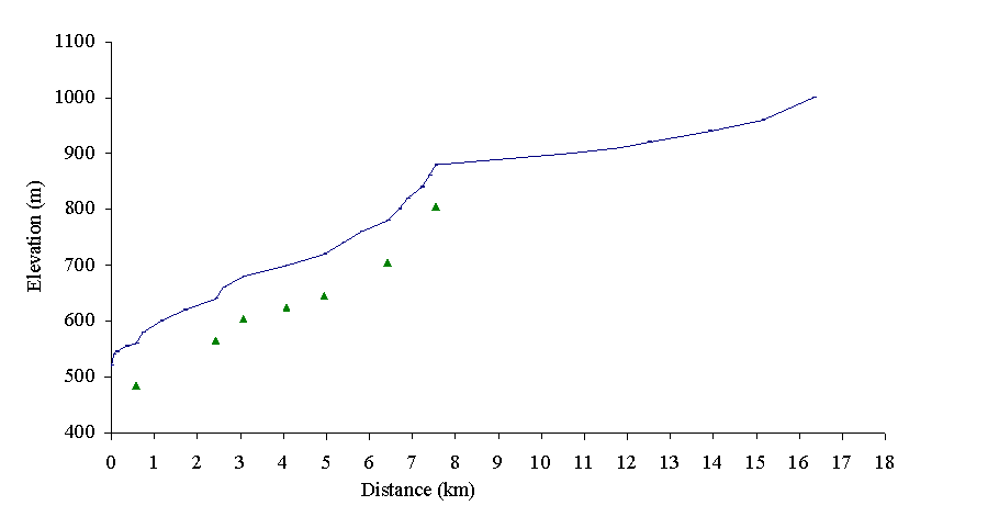
Figure 2. Gradient profile of the mainstem of Quesnel River delineated into ten reaches by triangles.
Water survey of Canada has two gauging stations on the river: station 08KH006 is located near Quesnel, and station 08KH001 is located in reach 9 at the outlet of Quesnel Lake (Table 1). The water flow regime was discussed in the Introduction. Quesnel Lake supplies half of the water volume of Quesnel River.
Fish use
The Quesnel River mainstem provides valuable habitat for numerous life stages of many salmon and non-salmon species. Chinook (Oncorhynchus tshawytscha), sockeye (O. nerka), kokanee (O. nerka), coho (O. kisutch) and pink salmon (O. gorbuscha) spawn in Quesnel River and Lake. Rainbow trout (O. mykiss), burbot (Lota lota), Dolly Varden (Salvelinus malma), sucker (Catostomus sp.), sculpin (Cottus sp.), and dace (Rhinichthys sp.) reside in the mainstem and Quesnel Lake. In addition, lake trout (Salvelinus namaycush), bull trout (S. confluentus), chiselmouth (Acrocheilus alutaceus), mountain whitefish (Prosopium williamsoni), and American shad (Alosa sapidissima) reside in Quesnel Lake (FISS, 1994; Appendix B1).
Sockeye salmon use the system as a migration corridor to their spawning beds off Quesnel Lake and in Mitchell and Horsefly rivers (Fish Habitat Inventory And Information Program, 1991). Coho salmon and rainbow trout spawn downstream of Quesnel Lake to Likely Fish Hatchery. Chinook salmon spawn in Cariboo River, in the narrows of Quesnel River and at the bridge near Likely. Dolly Varden spawn from the Likely bridge downstream to the hatchery and kokanee salmon spawn at the narrows. The canyon upstream of the Barlow Creek and Quesnel River confluence is a gradient barrier to pink salmon (Lamont, 1991).
Habitat enhancement activities on the Quesnel River include the salmon enhancement hatchery and spawning channel at Likely and on the Horsefly River. Artificial enhancement projects on the Quesnel River mainstem are not recommended as the spawning grounds near Likely are well used and have stable escapements. Salmon escapements, tallied by the Department of Fisheries and Oceans, are 150 sockeye salmon, 100 coho, 4000 pink and 9000 chinook over a ten year period (Fish Habitat Inventory and Information Program, 1990).
Forestry and resource use
Along the lower mainstem of Quesnel River, 12 km2 have been logged since 1990 while 22 km2 were logged earlier (Rood and Hamilton, 1995). Approximately 127 km2 of the upper Quesnel River has been logged since 1990, while about 18 km2 was logged prior to that (Rood and Hamilton, 1995). Log drives were discontinued in 1980 (Fish Habitat Inventory and Information Program, 1991). Harvesting has taken place in many of the sub-basins, however mainstem channel disturbances visible on the air photographs and from the helicopter reconnaissance appeared to be from natural slides.
Approximately 155 km2 of the lower Quesnel River and 56 km2 of the upper river are used as farmland. High intensity irrigation along the lower river has resulted in water shortages in several tributaries, but flow in the main channel has not been seriously affected (Rood and Hamilton, 1995). Changes in the drainage patterns have caused bank erosion on the Quesnel River (Photo 1). Natural slumping of the clay banks in numerous locations has caused considerable siltation. Both hydraulic and placer mining have caused extensive sediment disturbances along fish-bearing creek beds throughout the watershed. The frequency of natural slides and old mining activity, for example the Bullion Mine, have resulted in sediment build up in the reach between Morehead Creek and Quesnel Forks on the upper Quesnel River. Several natural slides are apparent along the mainstem (Photo 2), but some slides are triggered by upslope activities (Photo 3). Wells Grey Park and several smaller provincial parks are found along Quesnel Lake. Ten British Columbia Forest Service Recreation sites are found near Quesnel Forks and around Quesnel Lake.
Photo 1. Bank erosion caused by channeled drainage through a poorly designed and located culvert in reach 2.
Photo 2. Natural bank failure on Quesnel River mainstem in reach 8. Quesnel River flows from right to left in photograph.
Photo 3. Upslope failure into Quesnel River caused by mass wasting effluent from a first order tributary in reach 6, near the confluence with Beaver Valley Creek. Quesnel River flows from the top to bottom of the photograph.
Habitat condition and preliminary assessment
Ten stream reaches were delineated on the Quesnel River (Figure 2). The Habitat Condition Summary Form in Appendix C1 provides a general description of the stream habitat conditions. Table 2 provides a brief summary of the environmental impacts, assigned priority for Level 1 assessment, and preliminary restoration opportunities.
Table 2. Preliminary assessment of environmental impacts, priority for Level 1 work and restoration opportunities on the mainstem of the Quesnel River.
|
Reach |
Channel |
Channel |
Habitat |
Upslope |
Potential Impacts |
Priority‡ |
Restoration |
|
Num. |
Type* |
Stability† |
Value‡ |
Impact‡ |
|
|
Opportunities |
|
1 |
RPgw |
S |
H |
H |
Railway and highway related sedimentation. |
H |
Re-vegetation if necessary. |
|
2 |
RPgw |
S |
H |
H |
Pipeline and hydroline related sedimentation. |
H |
Re-vegetation if necessary. |
|
3 |
RP |
S |
H |
H |
Agricultural activities and road-related sedimentation. |
H |
Re-vegetation if necessary. |
|
4 |
RP |
S |
H |
H |
Road-related sedimentation and hindrance of development of back channels. Natural slides occur along riverbanks. |
H |
Re-vegetation if necessary. Establish back channels if required |
| |
RP |
S |
H |
H |
Historical and current mining activity related sedimentation. |
H |
Re-vegetation if necessary. Establish settling ponds for isolating sediment. |
|
9 |
RP |
S |
H |
H |
Road-related sedimentation. |
H |
Re-vegetation if necessary. |
The following briefly describes areas of concern on Quesnel River on a reach basis. Reach 1 flows through the city of Quesnel and has two highway bridge crossings, as well as riverside pathways and residential and commercial developments along the banks. The river channel is broad in reaches 1 and 2 with a few exposed gravel bars amongst the boulders and cobble. There are a few cascades and some pool areas.
In reach 2 there are several right-of-ways (ROW’s) associated with hydro lines, railway and pipeline crossings affecting the river. The sparse vegetation that is maintained within the ROW’s makes the riverbank vulnerable to erosion. The road crossings and urban development have impacted reaches 1 and 2 of the Quesnel River. Re-vegetation of riparian areas that are vulnerable to erosion should be considered.
A short canyon, called Big Canyon, separates reaches 2 and 3 and forms a velocity barrier to pink salmon (Lamont, 1991). Reaches 3 and 4 are less confined than reaches 1 and 2, as the river channel has a few back channels with the water flowing through pool habitats with cascades and boulders. Agricultural development and logging roads along the north side of the river in reach 3 need to be assessed for landslide potential. The riparian area should also be re-vegetated, if possible. Sardine Creek drains into reach 4 and was re-channeled to accommodate farmland on the banks of the Quesnel River. The Quesnel-Hydraulic Forest Service Road, which crosses the Quesnel River at Grenville Ferry in reach 4, should be assessed for potential sediment input. The farmland on Sardine Flats, in reach 4, may be hindering the development of back channels on the Quesnel River.
Reaches 5 through 7 consist of a channel that is stable but contains more sediment than the other reaches, due to natural landslides. The boulders, cascades and pools in the river channel appear to be aggraded by sediment that has slumped from the riverbanks or has been transported from the tributaries. Creeks draining into these reaches typically have steep gradients where they meet with Quesnel River.
Historical and modern-day mining activities have increased the sediment input into the Quesnel River near Quesnel Flats in reach 8. This has aggraded the channel, which contains several exposed gravel bars and back channels. Woody debris is obvious in this reach.
Reach 9 contains a natural narrowing of the river, called Quesnel Narrows, that broadens toward Quesnel Lake. The bridge crossing into Likely, in reach 9, as well as the connecting road, may be potential sediment sources.
Recommendations
Fish habitat restoration opportunities on the Quesnel River are limited due to its size and flow rate, which make the river a hazardous place to work. Despite the large size of the river, the riverbank and riparian area should be re-vegetated or bioengineered to limit the impacts on the fish habitat. Bank stabilization is suggested as a possible means to limit the slumping caused by rural and urban development. Restoration opportunities at Sardine Flats are discussed in the section on Sardine Creek.
Bucket Number 484
Bucket 484 contains five third order creeks at the 1:50,000 map scale. The sub-basins are Dragon Creek, Barlow Creek, Deacon Creek, Cantin Creek and Gerimi Creek.
Dragon Creek
Sub-basin area
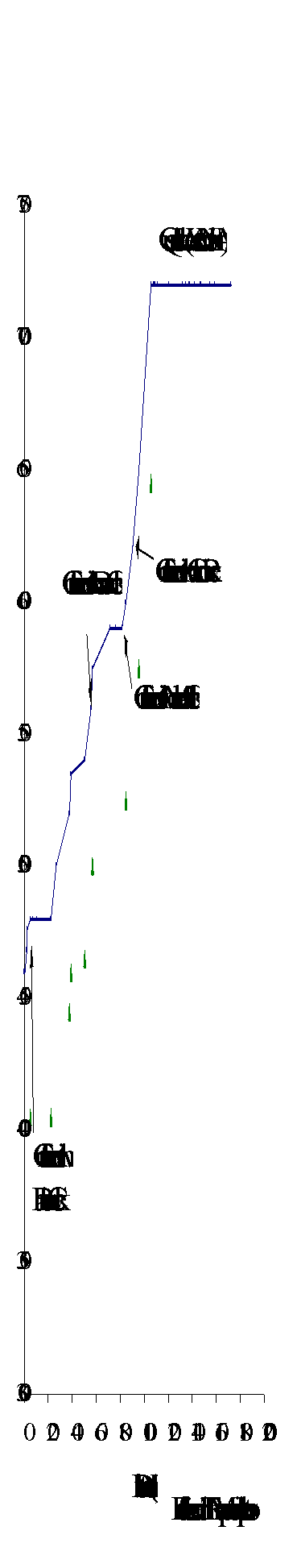
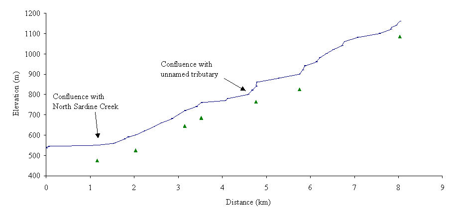
Dragon Creek (160-0017) flows southeast into the Quesnel River 160 m upstream of the Quesnel and Fraser River confluence. The creek drains an area of 7 km2 and has a mainstem length of 16 km (Figure 3). There are two major lakes along the mainstem drainage: Dragon Lake, located 5 km upstream of the confluence, and Hallis Lake, located 9 km upstream of Dragon Lake (Figure 4).
Water Survey of Canada has two gauging stations on the creek. Station 08KH016 is located in the lower section of reach 2 approximately 2 km upstream of the Quesnel River confluence, and station 08KH023, located in reach 4 approximately 3.5 km upstream of Dragon Lake (Table 1). The 7-day low flow for summer and winter varies between 0.001 and 0.004 m3 s-1 respectively; the mean annual flow for the sub-basin was not available (Table 1; Rood and Hamilton, 1995). Water flow is regulated by dams in two locations: at the outlet of Dragon Lake and the outlet of a small lake in Reach 5.
Fish use
According to FISS (1994), Dragon Creek and Dragon Lake provide rearing and spawning habitat for rainbow trout and Dragon Lake whitefish (Appendix B2a). The Conservation Data Center indicated that Dragon Lake supported Dragon Lake whitefish which are considered to be extinct (Anon., 1997). Rainbow trout have been stocked in reach 4 where spawning channels were developed immediately upstream of Dragon Lake (FISS, 1994).
Figure 3. Fish distribution based on the Overview assessment of Dragon, Barlow, Deacon, Cantin and Gerimi creeks (Bucket 484).
Resource use
The Quesnel-Hydraulic Forest Service Road passes over reach 4 and follows along the upper reaches of the creek. An estimated 90% of the sub-basin is private property, of which approximately 80% has been deforested for urban and rural developments (personal observation (pers. obs.), 1998). These developments are causing most of the impacts on the Dragon Creek sub-basin. For example, farmland on the eastern side of Dragon Lake is being converted into sub-division developments.

Figure 4. Gradient profile of Dragon Creek delineated into seven reaches by triangles.
Photo 4. Dragon Creek dam is located to the left of the road, near the outlet of Dragon Lake. Dragon Creek flows from left to right through the photograph.
Habitat condition and preliminary habitat assessment
Seven stream reaches were delineated on Dragon Creek. The Habitat Condition Summary Form in Appendix C2a provides a general description of the stream habitat conditions. Habitat concerns on Dragon Creek include low summer flow volumes in the lower reaches of the system, a potential migration obstruction in reaches 1 and 2 and winter kill conditions in Hallis Lake due to low dissolved oxygen levels. Table 3 provides a brief summary of habitat impacts, assigned priority for Level 1 assessment and preliminary habitat restoration opportunities.
The following briefly describes areas of concern on Dragon Creek on a reach basis. Reaches 1 and 2 of Dragon Creek dissect residential and commercial areas of Quesnel. In the first 130 m from the confluence of the Quesnel River and Dragon Creek, 15% gradients and low flows may act as potential barriers for fish access into this sub-basin. In reach 1, a trail and several road crossings have impacted the creek bed and riparian area. A Level 1 assessment should be undertaken to verify the extent of impacted habitat.
Reach 2 of Dragon Creek is within a gully that has been obscured by blowdown. It is suspected that the large woody debris (LWD) may decrease water flow. There is a road crossing and a water storage dam at the end of reach 2. Flow regulation at the dam may be affecting downstream fish habitat, as well as upstream fish passage. A more detailed assessment of the dam is recommended.
Table 3. Preliminary assessment of environmental impacts, priority for Level 1 work and restoration opportunities in Dragon Creek (Bucket Area 484).
|
Sub-basin |
Reach |
Channel |
Channel |
Habitat |
Upslope |
Potential Impacts |
Priority‡ |
Restoration |
|
Name |
Num. |
Type* |
Stability† |
Value‡ |
Impact‡ |
|
|
Opportunities |
|
Dragon Creek
160-0017 |
1 |
SPbw |
U |
H |
M |
Road-related migration barriers; eroding banks adjacent to access road |
M |
Crossing modification if required; |
| |
2 |
SPbw |
U |
H |
M |
Road-related migration barriers; log jam affecting fish access; dam at lake outlet |
M |
Crossing and dam modification, logjam removal or stream cleaning if required. |
| |
3 |
L |
S |
H |
L |
Water quality related effects; dam at lake outlet |
H |
Modify flow regulation; restore upstream access for fish; water treatment modification if required |
| |
4
|
RPgw |
U |
H |
M |
Road-related migration barriers; harvested riparian areas. |
H |
Crossing modification if required; re-vegetation if required |
| |
6
|
RPgw |
U |
H |
M |
Road-related migration barriers. |
L |
Crossing modification if required |
Along the shoreline of Dragon Lake, in reach 3, there are many residential homes and recreation facilities. According to FISS (1994), Dragon Lake has documented water quality concerns that may stem from nutrient overloading and shoreline alteration caused by the extensive urban development. Both of these habitat alterations would degrade the rearing habitats for rainbow trout and whitefish. This area should be assessed for habitat alteration, water quality and restoration opportunities.
Reach 4 is divided into two sections. Section A extends through a low lying wetland area and contains a rainbow trout spawning channel. Despite the habitat enhancement activity, an extensive housing sub-division is being developed in reach 4, section A, with a road crossing (pers. obs., 1998). Section B, which is characterized by a boulder cobble habitat, has three roads that may hinder fish access. All stream crossings in reach 4 should be assessed for fish passage.
Reach 5 contains low relief wetlands and a small dammed lake whose shoreline is paralleled by the Quesnel-Hydraulic Forest Service Road on the south side and has homestead on the north side. Reach 6 contains two stream crossings that should be assessed for fish passage. Hallis Lake, in reach 7, suffers from natural low oxygen levels resulting in winter kill of resident fish species (FISS, 1994).
Possible habitat restoration opportunities in Dragon Creek include the modification of culvert installations and removal of excessive amounts of woody debris.
Barlow Creek
Sub-basin area
 Barlow Creek
(160-0244) flows south into the Quesnel River approximately 5100 m upstream
of the Quesnel and Fraser River confluence (Figure 3). The creek drains an area
of 70 km2 and has a mainstem length of 17 km with six reaches delineated
on the gradient profile (Figure 5). The major body of water in the sub-basin
is 10-Mile Lake. Water Survey of Canada has a gauging station 08KH018 located
in reach 4 approximately 1 km downstream of 10–Mile Lake. The 7-day low
flow rates are 0.02 and 0.03 m3s-1 for the summer and
winter respectively (Table 1; Rood and Hamilton, 1995).
Barlow Creek
(160-0244) flows south into the Quesnel River approximately 5100 m upstream
of the Quesnel and Fraser River confluence (Figure 3). The creek drains an area
of 70 km2 and has a mainstem length of 17 km with six reaches delineated
on the gradient profile (Figure 5). The major body of water in the sub-basin
is 10-Mile Lake. Water Survey of Canada has a gauging station 08KH018 located
in reach 4 approximately 1 km downstream of 10–Mile Lake. The 7-day low
flow rates are 0.02 and 0.03 m3s-1 for the summer and
winter respectively (Table 1; Rood and Hamilton, 1995).
Figure 5. Gradient profile of Barlow Creek delineated into six reaches by triangles.
Fish use
Rainbow trout reside in Barlow Creek and 10-Mile Lake (FISS, 1994; Appendix B2b; Figure 3). 10-Mile Lake supports a recreational fishery for rainbow trout. Fish habitat enhancement activities include stream cleaning in reach 4. Concerns regarding water quality in 10-Mile Lake are related to residential developments along the lakeshore (FISS, 1994).
Forestry use
An estimated 90% of the sub-basin is private property, with several private and commercial developments along the creek (pers. obs., 1998). Recent forest harvesting appears to be minimal in this sub-basin and the historical forestry activities appear to have left riparian vegetation intact.
Habitat condition and preliminary habitat assessment
Six stream reaches were delineated on the mainstem of Barlow Creek. Habitat concerns include the numerous stream crossings, which should be assessed to determine if they are barriers to fish passage. The Habitat Condition Summary Form in Appendix C2b provides a general description of the stream habitat conditions. Table 4 provides a brief summary of the potential impacts, assigned priority for Level 1 assessment and preliminary restoration opportunities.
Table 4. Preliminary assessment of environmental impacts, priority for Level 1 work and restoration opportunities in Barlow Creek (Bucket Area 484).
|
Sub-basin |
Reach |
Channel |
Channel |
Habitat |
Upslope |
Potential Impacts |
Priority‡ |
Restoration |
|
Name |
Num. |
Type* |
Stability† |
Value‡ |
Impact‡ |
|
|
Opportunities |
|
Barrow
160-0024 |
1
2
3 |
U |
U |
H |
U |
Road-related migration barriers |
L |
Crossing modifications if required. |
| |
4 |
U |
U |
H |
U |
Road-related migration barriers Hydro line R.O.W. related impacts on the riparian vegetation |
H |
Crossing modifications if required; re-vegetation of riparian areas. |
| |
5 |
L |
S |
H |
L |
Water quality related effects |
L |
Water treatment modifications if required. |
| |
6 |
U |
U |
H |
U |
Three road-related migration barriers |
L |
Crossing modifications if required. |
The following briefly describes areas of concern on Barlow Creek on a reach basis. Residential and commercial developments occur along the first four reaches. Highway 97 crosses Barlow Creek in reach 1, as does the gas pipeline. A three line hydro-electric right-of-way crosses through reach 3, while the British Columbia Railway track parallels the creek in reaches 1, 2 and 3 and along East Barlow Creek. All stream crossings should be assessed for fish passage in a culvert inspection. 10-Mile Lake Provincial Park and Mouse Heights Provincial Park lie along the southwestern and northeastern shores of the lake, respectively. 10-Mile Lake, in reach 5, should be assessed for water quality and its effect on surrounding fish habitat.
Possible habitat restoration opportunities in Barlow Creek include the modification of stream crossings, if barriers to fish passage.
Deacon Creek
Sub-basin area
Deacon Creek (160-1089) flows into Quesnel River 22 km upstream of the Quesnel and Fraser River confluence (Figure 3). The creek has a mainstem length of 9 km with six reaches delineated in the gradient profile (Figure 6). Waterfalls, less than 20m in height, are found on Deacon Creek 100 m upstream of the confluence of Quesnel River and Deacon Creek (FISS, 1994). This feature is suspected to be a barrier to upstream migration and should be assessed.
Figure 6. Gradient profile of Deacon Creek with six reaches delineated by triangles.
Fish use
No fish species are documented in Deacon Creek (FISS, 1994; Appendix B2c). Fisheries inventory work is recommended to confirm the presence or absence of fish species and has been proposed for 1998 (Carmanah, in progress).
Forestry use
Forest activities have taken place in the upper reaches of Deacon Creek with minimal disturbance on fish habitat. The four cutblocks in the upper reaches of the sub-basin are away from the creek. The 500 Road and another road cross reach 6 may be causing sedimentation of the creek. A forestry reserve area protects part of reach 6.
Habitat condition and preliminary assessment
The Habitat Condition Summary Form in Appendix C2c provides a general description of the stream habitat conditions. Table 5 provides a brief summary of the environmental impacts, assigned priority for Level 1 assessment and preliminary restoration opportunities.
Table 5. Preliminary assessment of environmental impacts, priority for Level 1 work and restoration opportunities in Deacon Creek (Bucket Area 484).
|
Sub-basin |
Reach |
Channel |
Channel |
Habitat |
Upslope |
Potential Impacts |
Priority‡ |
Restoration |
|
Name |
Num. |
Type* |
Stability† |
Value‡ |
Impact‡ |
|
|
Opportunities |
|
Deacon
160-1089 |
1
|
SPr |
S |
U |
L |
Road-related sedimentation, natural slumping of river banks. |
L |
Crossing modification if required. |
| |
6 |
SPr |
S |
U |
L |
Road-related sedimentation |
L |
Crossing modification if required. |
The following briefly describes areas of concern on Deacon Creek on a reach basis. The channel in reach 1 is characterized by step pool habitat with a 20% gradient. In reach 1 the sediment input from the upslope areas naturally aggrades the lower section. Consequently, the water flow is altered by the creek bed changes and may become subterranean. The channel in reach 2 is composed of a boulder bed with cascades and pools. Reaches 3 through 5 are in the flood plain of the creek and are characterized by cascade pool habitat. A 1960’s harvested cutblock in reach 4 appears to be regenerating successfully. Reach 6 is a wetland area and the creek channel meanders extensively throughout the floodplain. In reaches 1 and 6, the stream crossings may be causing channel constriction and are potential sources of bank erosion. They should be assessed for fish access and sedimentation.
Possible habitat restoration opportunities in Deacon Creek include the modification of stream crossing installations. It is recommended that a fish inventory be conducted before any restoration opportunities are considered and that the suspected waterfall in reach 1 be assessed.
Cantin Creek
Sub-basin area
Cantin Creek (160-1282) flows south into the Quesnel River, 26 km upstream of the Quesnel and Fraser River confluence (Figure 3). The creek has a mainstem length of about 10 km with five reaches delineated in the gradient profile (Figure 7).
Figure 7. Gradient profile of Cantin Creek with five reaches delineated by triangles.
Fish use
According to FISS (1994), there are no data on fish or fish distribution within Cantin Creek (Appendix B2d). Fisheries inventory work is recommended to confirm the presence or absence of fish.
Forestry use
There are approximately 17 cutblocks in the headwaters of Cantin Creek (pers. obs., 1998). The cutblocks were harvested in the 1980’s and have caused no obvious disturbances to fish habitat as observed in air photos. The stream crossing in reach 5 provides access into other sub-basins.
Habitat condition and preliminary habitat assessment
The Habitat Condition Summary Form in Appendix C2d provides a general description of the stream habitat conditions. Table 6 provides a brief summary of the potential impacts, assigned priority for Level 1 assessment and preliminary restoration opportunities.
Table 6. Preliminary assessment of environmental impacts, priority for Level 1 work and restoration opportunities in Cantin Creek (Bucket Area 484).
|
Sub-basin |
Reach |
Channel |
Channel |
Habitat |
Upslope |
Potential Impacts |
Priority‡ |
Restoration |
|
Name |
Num. |
Type* |
Stability† |
Value‡ |
Impact‡ |
|
|
Opportunities |
|
Cantin
160-1282 |
5 |
RPcw |
S |
U |
L |
Road-related sedimentation and migration barriers. |
L |
Re-vegetation of upslope if required; crossing modification if required. |
The following briefly describes Cantin Creek on a reach basis. The creek channel in reach 1 is composed of cascade pool habitat with a 14% gradient. In reach 1, the sediment from upslope areas naturally aggrades the lower section. Consequently, the water flow is altered as the creek bed changes and may become subterranean. Increased water flow may stimulate further erosion. The channel in reach 2 meanders within a confined floodplain and is composed of a riffle pool habitat. Reaches 3 and 4 are characterized by gradients greater than 10% within cascade pool habitat. The channel in reach 5 has a 3% gradient, and is characterized by riffle pool habitat. In reach 5, the stream crossing may be causing channel constriction. The crossing should be assessed for fish access and sedimentation.
A possible habitat restoration opportunity in Cantin Creek includes the modification of culvert installations. It is recommended that a fish inventory be conducted before any restoration opportunities are considered.
Gerimi Creek
Sub-basin area
 Gerimi Creek
(160-1808) flows into the north side of the Quesnel River approximately 37 km
upstream of the Quesnel and Fraser River confluence (Figure 3). Gerimi Creek
has a length of 17 km with eight reaches delineated in the gradient profile
(Figure 8). Water Survey of Canada gauging station 08KH026 is located about
500 m upstream of the confluence with the Quesnel River (Table 1).
Gerimi Creek
(160-1808) flows into the north side of the Quesnel River approximately 37 km
upstream of the Quesnel and Fraser River confluence (Figure 3). Gerimi Creek
has a length of 17 km with eight reaches delineated in the gradient profile
(Figure 8). Water Survey of Canada gauging station 08KH026 is located about
500 m upstream of the confluence with the Quesnel River (Table 1).
Figure 8. Gradient profile of Gerimi Creek with eight reaches delineated by triangles.
Fish use
Rainbow trout reside in Gerimi Creek near the confluence of Gerimi Creek and the Quesnel River (FISS, 1994; Appendix B2e). Additional fisheries inventory work upstream of reach 1 is recommended to confirm the absence or presence of fish.
Forestry and Resource use
A cutblock harvested in 1995 lies in a low relief area of the sub-basin. Two historical cutblocks were noted to have adequate regeneration in the lower area of the sub-basin, with no observable negative effects on fish habitat. The community of Grenville Ferry is situated near the mouth of Gerimi Creek and is accessed by the Quesnel-Hydraulic Forest Service Road.
Habitat condition and preliminary assessment
The Habitat Condition Summary Form in Appendix C2e provides a general description of the stream habitat conditions. Table 7 provides a brief summary of the potential impacts, assigned priority for Level 1 assessment and preliminary restoration opportunities.
Table 7. Preliminary assessment of environmental impacts, priority for Level 1 work and restoration opportunities in Gerimi Creek (Bucket Area 484).
|
Sub-basin |
Reach |
Channel |
Channel |
Habitat |
Upslope |
Potential Impacts |
Priority‡ |
Restoration |
|
Name |
Num. |
Type* |
Stability† |
Value‡ |
Impact‡ |
|
|
Opportunities |
|
Gerimi
160-1808 |
1 |
SPr |
S |
H |
M |
Road-related migration barrier and sedimentation; natural slumping of creek banks. |
L |
Crossing modifications if required; re-vegetation if necessary. |
The following briefly describes areas of concern on Gerimi Creek on a reach basis. In reach 1, the upslope areas continually aggrade the channel. Reach 1 is characterized by step pool habitat. Approximately 100 m upstream of the mouth there is a high gradient (40%) section which likely limits upstream fish passage. A branch of the Quesnel-Hydraulic Forest Service Road crosses Gerimi Creek 110 m upstream of the mouth. This crossing should be assessed for fish access. The cutblocks in reach 8 have not disturbed fish habitat as seen in air photos.
Possible habitat restoration opportunities in Gerimi Creek include the re-vegetation of upslope areas around the bridge in reach 1. It is recommended that a fish inventory be conducted before any restoration opportunities are considered.
Summary of recommendations
This Overview identifies reaches in streams that have been potentially disturbed by forest harvesting, and focuses Level 1 field assessment on these specific reaches. In Bucket 484, only a few reaches were recommended for field assessment. Limitations encountered include the lack of fisheries distribution and limited forest harvesting and development information.
Dragon Creek
- Conduct a Level 1 assessment of reaches 1 through 4;
- Conduct a Fish Passage and Culvert Inspection in reaches 1, 2, and 4;
- Assess the water quality in Dragon Lake.
Barlow Creek
- Conduct a Fish Passage and Culvert Inspection in reaches 1, 2, 3, 4 and 6;
- Assess the water quality in 10-Mile Lake.
Deacon Creek
- Conduct a fish inventory to determine presence or absence of fish in the creek;
- Assess the stream crossing in reaches 1 and 6 of Deacon Creek for fish access and sediment generation.
Cantin Creek
- Conduct a fish inventory to determine presence or absence of fish in the creek;
- Assess the stream crossings in reach 5 of Cantin Creek for fish access or sediment generation.
Gerimi Creek
- Conduct a fish inventory to determine presence or absence of fish in the creek;
- Assess the stream crossings in reach 1 of Gerimi Creek for fish access and sediment generation.
Bucket Number 464a
Bucket 464a consists of two third order creeks, Sardine and Towler creeks, at the 1:50,000 map scale.
Sardine Creek
Sub-basin area
Sardine Creek (160-1829) flows northwest into the Quesnel River, 39 km upstream of the Quesnel and Fraser River confluence (Figure 9). The creek has a mainstem length of nine km with eight reaches delineated in the gradient profile (Figure 10). Sardine Creek drains from elevations of 1380 m through a series of cascades and falls into a wetland area. It flows through a second series of cascades and pools to the agricultural area called Sardine Flats. This area has a few homesteads on it. The Quesnel-Hydraulic Forest Service Road connects Sardine Flats with the Grenville Ferry area across the Quesnel River.
North Sardine Creek (160-1829-105) and unnamed tributary (160-1829-528) drain into Sardine Creek. North Sardine Creek leaves Sardine Creek at the edge of Sardine Flats near a small pond. The unnamed tributary branches off Sardine Creek in reach 6.
Fish use
Chinook salmon migrate to reach 6 of Sardine Creek and into the unnamed tributary and lake (FISS, 1994; Appendix B3a). Chinook spawn and rear in the unnamed tributary (FISS, 1994). Rainbow trout are in Sardine Creek and in the unnamed tributary and lake.
Figure 9. Fish distribution based on the Overview assessment of Sardine and Towler creeks (Bucket 464a).
Forestry and Resource use
 Forestry activity
has developed several roads with crossings in reaches 6 through 8 of Sardine
Creek and in the unnamed tributary. An estimated 20 cutblocks along reaches
6 through 8, harvested in the 1960’s, appear to have appropriate forest
regeneration (pers. obs., 1998). The Quesnel-Hydraulic Forest Service Road crosses
Sardine Creek in reach 1 and appears to block the development of back channels
of the Quesnel River. Agricultural activities in reach 1, Sardine Flats, have
caused re-channeling of Sardine Creek.
Forestry activity
has developed several roads with crossings in reaches 6 through 8 of Sardine
Creek and in the unnamed tributary. An estimated 20 cutblocks along reaches
6 through 8, harvested in the 1960’s, appear to have appropriate forest
regeneration (pers. obs., 1998). The Quesnel-Hydraulic Forest Service Road crosses
Sardine Creek in reach 1 and appears to block the development of back channels
of the Quesnel River. Agricultural activities in reach 1, Sardine Flats, have
caused re-channeling of Sardine Creek.
Figure 10. Gradient profile of Sardine Creek with eight reaches delineated by triangles.
Habitat condition and preliminary assessment
The Habitat Condition Summary Form in Appendix C3a provides a general description of the stream habitat conditions. Habitat concerns on Sardine Creek include a re-channeled mainstem in reach 1 and potential sediment and debris generation from roads that cross reaches 6 through 8. Table 8 provides a brief summary of the environmental impacts, assigned priority for Level 1 assessment and preliminary restoration opportunities.
Table 8. Preliminary assessment of environmental impacts, priority for Level 1 work, and restoration opportunities in Sardine Creek (Bucket Area 464a).
|
Sub-basin |
Reach |
Channel |
Channel |
Habitat |
Upslope |
Potential Impacts |
Priority‡ |
Restoration |
|
Name |
Num. |
Type* |
Stability† |
Value‡ |
Impact‡ |
|
|
Opportunities |
|
Sardine
160-1824 |
1 |
RPgw |
S |
H |
H |
Road-related migration barriers or sediment sources and restricted side channel development. |
H |
Crossing modifications if required |
| |
6
7
8 |
CPb
CPb
SPr |
S |
M |
L |
Road-related sediment generation. |
L |
Re-vegetation if necessary. |
The following briefly describes areas of concern on Sardine Creek on a reach basis. An artificially confined channel with riffle pool habitat forms the creek in reach 1. In reach 1, the all stream crossings should be assessed for fish passage and causing potential fish habitat degradation. The creek channel is confined in reaches 2 through 6 and is characterized by a cascade pool habitat. Reaches 7 and 8 have gradients of 100% and are composed of block step pool habitat. Potential debris and sediment accumulation in pools downstream of the stream crossings in reaches 6 through 8 should be assessed. In the unnamed tributary, the stream crossing should be assessed for fish passage.
A possible habitat restoration opportunity in Sardine Creek includes the rehabilitation of the stream channel in reach 1.
Towler Creek
Sub-basin area
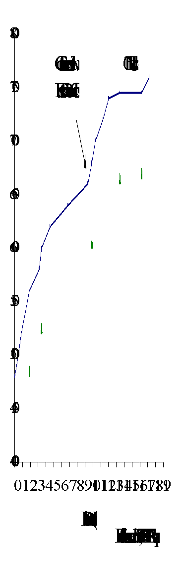
Towler Creek (160-2418) flows north into the Quesnel River approximately 50 km upstream of the Quesnel and Fraser River confluence (Figure 9). The creek has a mainstem length of 11 km with six reaches delineated in the gradient profile (Figure 11). Towler Creek flows from low-lying marshlands through steep cascades or waterfalls (gradient 18%) to low-lying flatlands near its mouth.
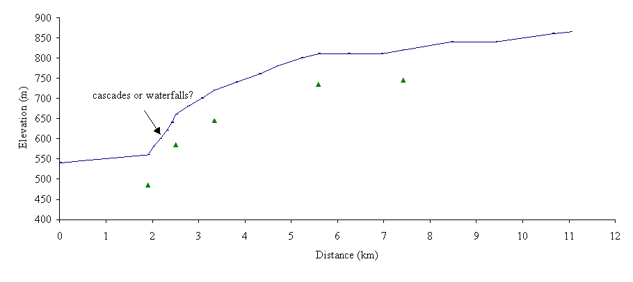
Figure 11. Gradient profile of Towler Creek delineating six reaches by triangles.
Fish use
According to FISS (1994), no fish species are documented in Towler Creek (Appendix B3b). However, the low channel gradient (1%) in reach 1 suggests that there may be fish habitat in this reach. Fisheries inventory work or fish sampling is recommended to confirm the presence or absence of fish.
Forestry use
No forestry related disturbances of fish habitat were observed other than road crossings in reaches 1 and 4 (pers. obs., 1998). Historical forest harvesting has removed timber from the upper area of the sub-basin with appropriate regeneration.
Habitat condition and preliminary assessment
The Habitat Condition Summary Form in Appendix C3b provides a general description of the stream habitat conditions. Habitat concerns on Towler Creek are mostly related to road-related migration barriers and sediment generation. Table 9 provides a brief summary of the potential impacts, assigned priority for Level 1 assessment and preliminary restoration opportunities for Towler Creek.
Table 9. Preliminary assessment of environmental impacts, priority for Level 1 work, and restoration opportunities in Towler Creek (Bucket Area 464a).
|
Sub-basin |
Reach |
Channel |
Channel |
Habitat |
Upslope |
Potential Impacts |
Priority‡ |
Restoration |
|
Name |
Num. |
Type* |
Stability† |
Value‡ |
Impact‡ |
|
|
Opportunities |
|
Towler
160-2418 |
1
|
RPcw |
S |
H |
L |
Road-related migration barrier or sediment generation. |
L |
Crossing modification if required. |
| |
4 |
RPcw |
S |
L |
L |
Road-related migration barrier or sediment generation. |
L |
Crossing modification if required. |
The following briefly describes areas of concern on Towler Creek on a reach basis. In reach 1, the creek channel is characterized by riffle pool habitat, which may contain cobble and some LWD. The mainline road crosses Towler Creek 400 m upstream of its mouth and the road crossing should be assessed for fish access. The channel in reaches 2 through 4 is confined and characterized by gradients less than 18%. The habitat in these reaches is composed of cascades and pools with some woody debris. The stream crossing in reach 4 may be impacting fish habitat. Reaches 5 and 6 are composed of a winding channel with riffle pool habitat.
A possible habitat restoration opportunity in Towler Creek includes the modification of crossings. A fish inventory assessment is recommended before any habitat restoration measures are considered.
Summary of recommendations
Sardine Creek
- Conduct a Level 1 assessment of reach 1 of Sardine Creek;
- Assess the stream crossings in reaches 6, 7, and 8 of Sardine Creek and in the unnamed tributary.
Towler Creek
- Determine the presence or absence of fish in Towler Creek;
- Assess the stream crossings in the sub-basin for fish passage.
Bucket Number 466
Morehead Creek
Sub-basin area
The Morehead Creek sub-basin (160-4155) forms Bucket 466. Morehead Creek flows west-northwest into Quesnel River about 85 km upstream of the Quesnel and Fraser River confluence (Figure 12). The creek has a mainstem length of 18 km with 11 reaches delineated in the gradient profile (Figure 13). Morehead Creek contains three tributaries; Little Lake (160-4155-127) and Warren creeks (160-4155-294) are located in the lower reaches of Morehead Creek, and Trio Creek (160-4155-689) is located in the headwaters of the sub-basin. Morehead Lake is the major lake in the system. Little, Prior Trio and Bootjack lakes are also part of the Morehead sub-basin. Prior Lake, in reach 5 of Little Lake Creek, has water quality concerns that may be associated with the sawmill located near its outlet (FISS, 1994).
Fish use
Chinook salmon spawn in reach 1 of Morehead Creek (FISS, 1994; Appendix B4). Rainbow trout reside in Morehead Creek, Morehead Lake Trio and Bootjack Lake. Reach 1 of Little Lake Creek contains non-game fish: cyprinid minnows, longnose suckers and redside shiners. Habitat enhancements in the sub-basin included the removal of a logjam in reach 2 on Little Lake Creek and stream cleaning in reach 3 of Trio Creek (FISS, 1994). The dam and spillway at the outlet of Morehead Lake are barrier to fish passages (C. Haeussler, pers. comm., 1998).
Figure 12. Fish distribution based on the Overview assessment of Morehead Creek (Bucket 466).
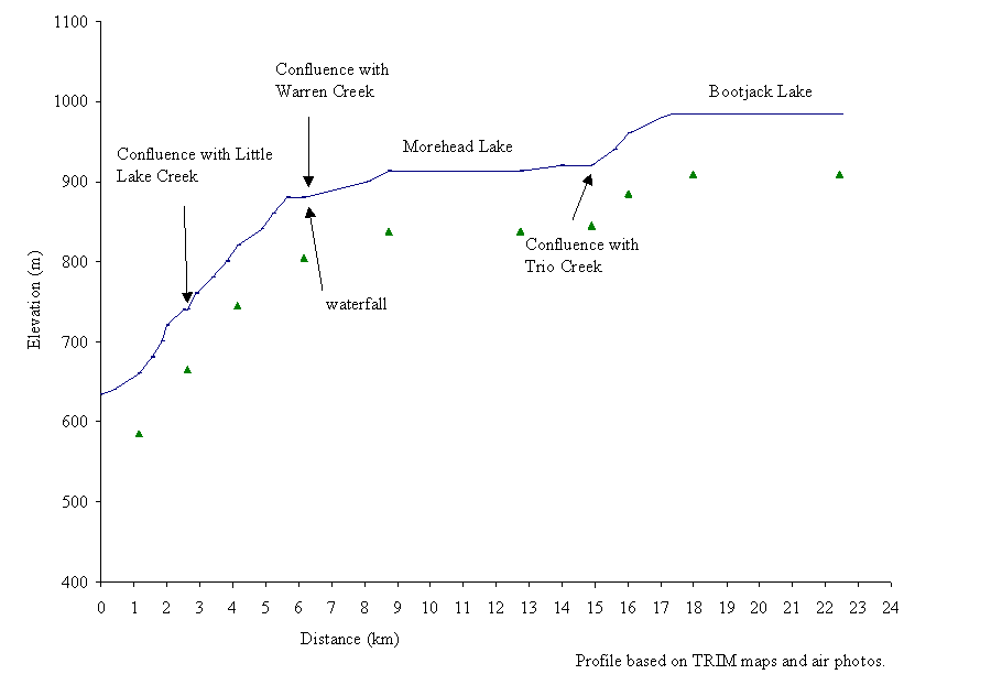
Figure 13. Gradient profile of Morehead Creek with 11 reaches delineated by triangles.
Forestry and resource use
Forest harvesting has occurred during the 1970’s and 1990’s in the upper reaches of Morehead Creek and tributaries, resulting in approximately 30 cutblocks (pers. obs., 1998). Most of the cutblocks are located along the upper reaches of the sub-basin from Morehead Lake to Bootjack Lake. Logging roads and cutblocks parallel and cross reaches 7 through 10. Portions of the riparian vegetation along the these reaches have been clearcut.
Placer and hydraulic mining activities in the Morehead Creek sub-basin have caused channel aggradation. This is noticeable in reaches 1 and 2 of Morehead Creek. Little Lake Creek has been similarly impacted by hydraulic mining activities. Morehead Lake and Bootjack Lake were dammed over 90 years ago to form water reservoirs for mining activities (M. Lauret, pers. comm., 1998).
Likely Road provides access into the Morehead Creek sub-basin and passes over Morehead and Little Lake creeks. The community of Hydraulic is located on the shoreline of Little Lake. Homesteads are also located along reaches 4 and 5 of Morehead Creek and on the shoreline of Morehead Lake.
Habitat condition and preliminary assessment
Nine reaches were delineated on the mainstem of Morehead Creek. A general description of the stream habitat conditions is provided on the Habitat Condition Summary Form in Appendix C4. Habitat concerns in Morehead Creek sub-basin include altered streambeds due to mining activities and possible road-related migration barriers. Table 10 provides a brief summary of the potential impacts, assigned priority for Level 1 assessment, and preliminary restoration opportunities.
The following briefly describes areas of concern on Morehead Creek on a reach basis. In reaches 1 and 2 of Morehead Creek the cobble and gravel substrate of the creek bed provides a spawning area for chinook salmon. Reach 1 of Morehead Creek has been impacted by mining activity (Photo 5). A truck was noted in the creek and the stream crossing was washed out. The reach should be assessed for fish habitat impacts. Recent natural slumping of the steep upslope area in reach 2 has caused siltation of the creek water and pool areas. The gradient of Morehead Creek is 7% in reach 3, where the channel is characterized by boulders and pools. Historical upstream hydraulic mining on Little Lake Creek has aggraded the channel in reaches 2 and 3.
Reach 4 of Morehead Creek has a steep gradient that forms a natural barrier to fish migration (Photo 6). In reach 4 a newly constructed hydro dam and associated road may impact the downstream habitat and should be assessed. In reach 5, Morehead Creek meanders through a low-lying wetland and is isolated from Morehead Lake by an armored culvert that supports Likely Road (Photo 7). The dam and spillway at the outlet of Morehead Lake restricts the water flow out of the lake and limits fish passage (C. Haeussler, pers. comm., 1998). Several cabins are located along Morehead Lake. Morehead Lake, in reach 6, appears to have an impacted riparian area resulting from a cutblock and the highway right-of-way.
Table 10. Preliminary assessment of environmental impacts, priority for Level 1 work, and restoration opportunities in Morehead Creek (Bucket Area 466).
|
Sub-basin |
Reach |
Channel |
Channel |
Habitat |
Upslope |
Potential Impacts |
Priority‡ |
Restoration |
|
Name |
Num. |
Type* |
Stability† |
Value‡ |
Impact‡ |
|
|
Opportunities |
|
Morehead
160-4155 |
1 |
CPcw |
S |
H |
H |
Road and mining related disturbances |
H |
Re-vegetation if possible |
| |
2 |
CPb |
S |
H |
M |
Mining related disturbances |
H |
Re-vegetation if possible |
| |
4 |
SPr |
S |
M |
H |
Road and hydro dam construction related sedimentation |
H |
Assess construction activities and road access. |
| |
5 |
RPgw |
S |
H |
M |
Road-related migration barrier |
M |
Culvert modification if required |
| |
7
8 |
RPgw |
S |
H |
H |
Road-related migration barrier harvesting into the riparian area |
H |
Culvert modification if required; re-vegetation if possible. |
| |
9
10 |
RPgw |
S |
H |
L |
Road-related migration barrier harvesting into the riparian area |
H |
Culvert modification if required Re-vegetation if possible. |
| |
11 |
L |
S |
H |
L |
Harvesting into the riparian area |
L |
Re-vegetation if possible. |
| |
|
Little Lake
160-4155-127 |
2 |
SPb |
S |
M |
L |
Road-related migration barrier |
L |
Culvert modification if required |
| |
3 |
L |
S |
M |
L |
Water quality related |
L |
Water treatment modification if possible |
| |
4 |
CPcw |
S |
M |
L |
Road-related migration barriers. |
L |
Culvert modification if required |
| |
|
Warren
160-4155-294 |
1
4
5 |
RPgw |
S |
L |
L |
Road-related migration barriers. |
L |
Culvert modification if required |
| |
|
Trio
160-4155-294 |
1
2
5 |
RPgw |
S |
M |
M |
Road-related migration barriers. |
L |
Culvert modification if required |
Reaches 7 through 10 are located above Morehead Lake and are characterized by low-lying wetlands. These reaches contain stream crossings that should be assessed for fish passage. The riparian vegetation in reaches 7 and 9 was harvested in 1986 and 1972, respectively. Forest cover in both areas appears to have regenerated. Reach 10 was dredged approximately 90 years ago to alter the water flow from Bootjack Lake (M. Lauret, per. com., 1998). Reach 11 is composed of Bootjack Lake and contains a dam at the southeastern end. Some of the riparian vegetation along the south side of the lake was harvested.
Photo 5. Reach 1 of Morehead Creek. Historically a chinook spawning area, this reach has been impacted by placer mining activities. The upslope vegetation is disturbed and a truck is in the streambed.
Photo 6. Impassable waterfalls are located immediately downstream of a hydro dam that is under construction in reach 4 of Morehead Creek.
Photo 7. A dam and spillway is located at the outlet of Morehead Lake. Likely Road bisects the photograph.
Little Lake Creek (160-4155-127) flows into Morehead Creek approximately 2.5 km upstream of the Morehead Creek and Quesnel River confluence. Historical upstream mining activity has severely aggraded reach 1 of Little Lake Creek. Reach 2 has three stream crossings that may be barriers to fish passage. Several residences that are part of the community of Hydraulic are located on the shore of Little Lake, in reach 3. The sawmill and septic tanks of the residences may affect the water quality and fish habitat of Little Lake. Likely Road and another road pass across the wetlands of reach 4 of Little Lake Creek. These stream crossings may be hindering fish passage and should be assessed.
Reaches 2, 3 and 4 of Trio Creek (160-4155-689) contain stream crossings that should be assessed for potential downstream effects on water quality and fish access.
Possible habitat restoration opportunities in Morehead Creek include the removal of the truck in reach 1 and the modification of stream crossings in the sub-basin. These activities may improve fish passage and decrease sedimentation of the creek.
Recommendations
- Conduct a Level 1 assessment of reaches 1 through 8 of Morehead Creek;
- Assess the stream crossing and remove the truck in reach 1;
- Conduct a Fish Passage Culvert Inspection of the Morehead Creek sub-basin.
Bucket Number 474
Maud Creek
Sub-basin area
The Maud Creek (160-4401) sub-basin forms Bucket 474. Maud Creek flows southeast into the Quesnel River about 90 km upstream of the Quesnel and Fraser River confluence (Figure 14). Maud Creek has a mainstem length of 18 km with seven reaches delineated by the longitudinal profile (Figure 15). Le Bourdais Creek (160-4401-245) flows into Maud Creek from the northeast 5 km upstream of the Maud Creek and Quesnel River confluence. This creek drains Le Bourdais Lake. Maud Lake is the major lake in the sub-basin and forms the headwaters of Maud Creek.
Fish use
According to FISS (1994), chinook salmon spawn at the confluence of Maud Creek and the Quesnel River (Photo 8; Appendix B5). Rainbow trout reside throughout the stream, despite the steep cascades in reach 3 (Photo 9). Dolighan and Lirette (1991) surveyed rainbow trout spawning sites in a section of upper Maud Creek. They stated that rainbow trout juveniles in tributaries are important for producing adult sport fish in Maud Lake and require adequate protection. Non-game fish in the system are longnose suckers, sucker species and redside shiners.
Figure 14. Fish distribution based on the Overview assessment of Maud Creek (Bucket 474).
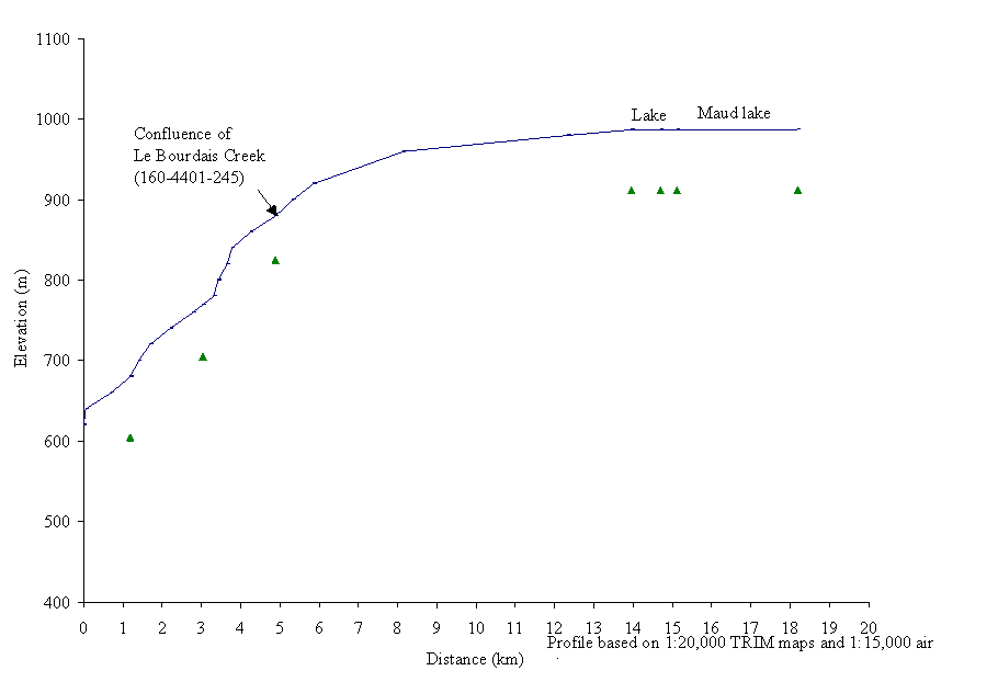
Figure 15. Gradient profile of Maud Creek with seven reaches delineated by triangles.
Photo 8. Chinook spawning grounds at the confluence of Maud Creek and Quesnel River, as seen in October 1997. The Quesnel River flows from right to left across the lower section of the photograph.
forestry and Resource use
Approximately 35 cutblocks, harvested in the 1990’s, were observed in air photos of the upper areas of the Maud Creek sub-basin (pers. obs., 1998). Portions of Maud Creek and Le Bourdais Creek appear to have narrow riparian areas. Forest access roads and stream crossings may be disturbing fish habitat on Maud and Le Bourdais creeks. Placer mining activity has changed the lower creek area by increasing bank erosion and sedimentation (Photo 10). A Forest Service Site is located on Maud Lake.
Habitat condition and preliminary assessment
Seven reaches are delineated on the gradient profile of Maud Creek. The Habitat Condition Summary Form in Appendix C5 provides a general description of the stream habitat conditions. Habitat concerns on Maud Creek include riparian areas impacted by forestry and mining activities and culvert installations that may hinder fish passage. Table 11 provides a brief summary of the potential impacts, assigned priority for Level 1 assessment and preliminary restoration opportunities.
Table 11. Preliminary assessment of environmental impacts, priority for Level 1 work and restoration opportunities on Maud Creek (Bucket Area 474).
|
Sub-basin |
Reach |
Channel |
Channel |
Habitat |
Upslope |
Potential Impacts |
Priority‡ |
Restoration |
|
Name |
Num. |
Type* |
Stability† |
Value‡ |
Impact‡ |
|
|
Opportunities |
|
Maud |
1 |
CPb |
A |
H |
H |
Mining related impacts |
H |
Re-vegetation riparian area |
|
160-4401 |
4 |
RPcw |
S |
H |
H |
Harvesting into the riparian area; road-related migration barrier |
H |
Re-vegetation riparian area. Crossing modification if required |
|
|
Le Bourdais |
2 |
CPb |
S |
H |
L |
Road-related migration barrier |
L |
Crossing modification if required |
|
160-4401-245 |
4 |
RPcw |
S |
H |
L |
Road-related migration barrier |
L |
Crossing modification if required |
Photo 9. Waterfalls in reach 3 of Maud Creek. Rainbow trout are documented above and below the waterfalls.
Photo 10. Placer mining along reach 1 of Maud Creek. The creek flows from left to right in the photograph.
The following briefly describes areas of concern on Maud Creek on a reach basis. In reach 1 gradients of approximately 36% may be natural barriers to upstream migration. Placer mining activity has aggraded reach 1 of Maud Creek. Reach 2 has 10% gradients that may limit fish passage or movement although the creek bed is composed of boulders with some pools. Waterfalls (height less than 20 m) in reach 3 may also act as barriers to fish passage or movement. Maud Creek begins to meander, in reach 4, above the confluence with Le Bourdais Creek, and the channel contains more pools, riffles and woody debris. Stream crossings in reach 4 may inhibit fish migration and cause sediment input. The riparian vegetation in part of reach 4 has been harvested in the 1990’s and should be assessed to quantify habitat impacts. Reaches 5 through 7 are composed of lakes and wetlands.
The roads that cross reaches 2 and 4 of Le Bourdais Creek should be assessed as potential fish barriers and sediment sources.
Possible habitat restoration opportunities in the Maud Creek sub-basin include bioengineering of exposed and poorly vegetated creek banks.
Recommendations
- Conduct a Level 1 assessment in reach 4 of Maud Creek;
- Conduct site checks of stream crossings in the sub-basin.
Bucket Number 464b
Bucket 464a contains three creeks, which are third-order at the 1:50,000 map scale, Annette, Whiffle and Abbott creeks. The bucket area lies along the West and East arms of Quesnel Lake (Figure 16 inset).
Annette Creek
Sub-basin area
Annette Creek (160-6416) drains into Quesnel Lake, in Hobson Arm, 26 km from the outlet (Figure 16). The creek has a mainstem length of 6 km with nine reaches delineated in the gradient profile (Figure 17). There are two major lakes along the mainstem drainage; Annette Lake is located 1 km upstream of the confluence with Quesnel Lake, and Freshette Lake is located 3 km upstream of the confluence with Quesnel Lake.
From its headwaters at an elevation of 1240 m, Annette Creek cascades into the wetlands of Freshette Lake. Freshette Lake also receives water from Benny Lake. Annette Creek flows from Freshette Lake through wetlands into Annette Lake. A final series of cascades lets the water flow from Annette Creek into Quesnel Lake.
Fish use
Rainbow trout have been found in reaches 1, 4, 5 and 6 of this creek (FISS, 1994, Appendix B6a). Steep gradients (50%) in reach 2 may limit the upstream migration of fish.
Figure 16. Fish distribution based on the Overview assessment of Annette and Whiffle creeks (Bucket 464b).
Habitat condition and preliminary assessment
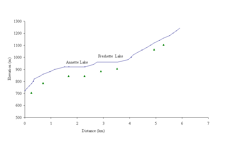 Our
helicopter reconnaissance on October 8, 1997, found only one cutblock, a recent
one, on the hillside west of Annette Lake. The air photo review confirmed that
this is the only cutblock in the sub-basin. The Habitat Condition Summary Form
in Appendix C6a provides a general description of the stream habitat conditions.
Although overhanging vegetation obscures the channel of Annette Creek, it is
highly unlikely that the single cutblock, which is located well away from the
stream, has had any negative impacts on fish habitat.
Our
helicopter reconnaissance on October 8, 1997, found only one cutblock, a recent
one, on the hillside west of Annette Lake. The air photo review confirmed that
this is the only cutblock in the sub-basin. The Habitat Condition Summary Form
in Appendix C6a provides a general description of the stream habitat conditions.
Although overhanging vegetation obscures the channel of Annette Creek, it is
highly unlikely that the single cutblock, which is located well away from the
stream, has had any negative impacts on fish habitat.
Figure 17. Gradient profile of Annette Creek delineating nine reaches by triangles.
Whiffle Creek
Sub-basin area
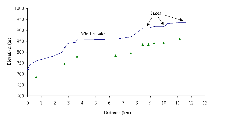 Whiffle Creek
(160-6724) flows into Quesnel Lake southwest of Plato Island, 32 km from the
outlet of Quesnel Lake (Figure 16). The creek has a mainstem length of 12 km
with 11 reaches delineated by the gradient profile (Figure 18). Whiffle Lake
is the largest lake in the sub-basin. There is a chain of three smaller lakes
in the headwaters of the creek.
Whiffle Creek
(160-6724) flows into Quesnel Lake southwest of Plato Island, 32 km from the
outlet of Quesnel Lake (Figure 16). The creek has a mainstem length of 12 km
with 11 reaches delineated by the gradient profile (Figure 18). Whiffle Lake
is the largest lake in the sub-basin. There is a chain of three smaller lakes
in the headwaters of the creek.
Figure 18. Gradient profile of Whiffle Creek with 11 reaches delineated by triangles.
Fish use
No target fish species are documented in Whiffle Creek (FISS, 1994; Appendix B6b). A fish inventory is recommended to determine the presence or absence of target species. Non-game fish, such as longnose suckers (Catostomus catostomus), northern squawfish (Ptychocheilus oregonensis), peamouth chub (Mylocheilus caurinus), and redside shiners (Richardsonius balteatus) have been collected up to Whiffle Lake (FISS, 1994). There is no gradient barrier that would limit the upstream migration of target fish, so fish are suspected to access the lakes in the headwaters of Whiffle Creek.
Forestry use
Approximately 23 cutblocks have been harvested in the Whiffle Creek sub-basin (pers. obs., 1998). Forest harvesting in 1984 has removed the riparian vegetation along a portion of Whiffle Lake. The headwaters of the creek, which flow through low gradient wetlands, have poor riparian vegetation.
Habitat condition and preliminary assessment
The Habitat Condition Summary Form in Appendix C6b provides a general description of the stream habitat conditions. Habitat concerns include harvesting-related sediment generation in upper reaches. Table 12 provides a brief summary of the potential impacts in each reach, assigned priority for Level 1 assessment and preliminary restoration opportunities.
Table 12. Preliminary assessment of environmental impacts, priority for Level 1 work and restoration opportunities in Whiffle Creek (Bucket Area 464b).
|
Sub-basin |
Reach |
Channel |
Channel |
Habitat |
Upslope |
Potential Impacts |
Priority‡ |
Restoration |
|
Name |
Num. |
Type* |
Stability† |
Value‡ |
Impact‡ |
|
|
Opportunities |
|
Whiffle
160-6724 |
3 |
CPcw |
S |
M |
M |
Road-related migration barrier |
M |
Crossing modification if required |
|
4 |
L |
S |
M |
L |
Harvesting into the riparian area |
L |
Re-vegetation of riparian area. |
|
7 |
L |
S |
L |
M |
Harvesting into the riparian area roads ford the creek |
M |
Re-vegetation of riparian area; crossing modification if required |
|
8 |
RPgw |
S |
L |
M |
M |
|
9 |
L |
S |
L |
M |
M |
|
10 |
RPgw |
S |
L |
M |
M |
|
11 |
L |
S |
L |
M |
M |
The following briefly describes areas of concern on Whiffle Creek on a reach basis. Gradients of 10-15% in reaches 1 and 3 may limit the upstream passage and movement of fish into Whiffle Creek. The stream crossing in reach 3 is a possible sediment source and fish migration barrier. Portions of the riparian area along reach 4 were harvested. The riparian vegetation was harvested along reaches 7, 8, 9, 10 and 11. These areas may be causing negative effects on fish habitat and should be assessed.
A possible habitat restoration opportunity in the Whiffle Creek includes the modification of stream crossings. Re-vegetation of the upper reaches of Whiffle Creek should be considered if a fish inventory confirms the presence of fish.
Abbott Creek
Sub-basin area
Abbott Creek (160-7068) flows southward into Quesnel Lake at Shoals Bay, 36 km from the outlet of Quesnel Lake (Figure 19). The creek has a mainstem length of 14 km with eight reaches delineated by the gradient profile (Figure 20). These reaches are similar to those delineated by Cariboo Envirotech Ltd. (1997a). Abbott Creek cascades from an elevation of 1680 m to wetlands and pools before dropping through another steep series of falls and cascades. Near the confluence of Abbott Creek with Quesnel Lake, Abbott Creek flows into a meandering, branching wetland area.
Fish use
FISS (1994) has no record of fish in this sub-basin. Cariboo Envirotech Ltd. (1997a) surveyed the creek and found rainbow trout, burbot and bull trout in the lower reaches (Appendix C6c; Figure 19). A waterfall, height less than 20 m, limits the upstream migration of fish.
Figure 19. Fish distribution based on the Overview assessment of Abbott Creek (Bucket 464b).
Forestry use
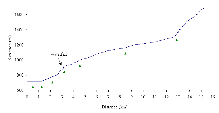 Forestry
activity in the 1990’s has harvested approximately 10 cutblocks in the
Abbott Creek sub-basin (pers. obs., 1998). There are several stream crossings
in the sub-basin including an access road across reach 3 of Abbott Creek (Photo
11). This road provides access to a cutblock that borders reach 1, which has
been designated as unsatisfactorily restocked. A Forest Service Recreational
Site is located on an unnamed tributary of Abbott Creek.
Forestry
activity in the 1990’s has harvested approximately 10 cutblocks in the
Abbott Creek sub-basin (pers. obs., 1998). There are several stream crossings
in the sub-basin including an access road across reach 3 of Abbott Creek (Photo
11). This road provides access to a cutblock that borders reach 1, which has
been designated as unsatisfactorily restocked. A Forest Service Recreational
Site is located on an unnamed tributary of Abbott Creek.
Figure 20. Gradient profile of Abbott Creek delineating eight reaches by triangles.
Habitat condition and preliminary assessment
The Habitat Condition Summary Form in Appendix C6c provides a general description of the stream habitat conditions. Habitat concerns on Abbott Creek include harvested riparian vegetation and road-related migration barriers. Table 13 provides a brief summary of the potential impacts, assigned priority for Level 1 assessment and preliminary restoration opportunities.
Table 13. Preliminary assessment of environmental impacts, priority for Level 1 work and restoration opportunities in Abbott Creek (Bucket Area 464b).
|
Sub-basin |
Reach |
Channel |
Channel |
Habitat |
Upslope |
Potential Impacts |
Priority‡ |
Restoration |
|
Name |
Num. |
Type* |
Stability† |
Value‡ |
Impact‡ |
|
|
Opportunities |
|
Abbott
160-7068 |
1 |
RPgw |
S |
H |
M |
Harvesting into the riparian areas. |
H |
Re-vegetation, if necessary |
|
3 |
RPgw |
S |
H |
H |
Road-related migration barrier; harvesting into the riparian area. |
H |
Crossing modification, if necessary.; re-vegetation, if necessary |
|
5 |
CPcw |
S |
L |
H |
Harvesting into the riparian area. |
L |
Re-vegetation, if necessary. |
|
6 |
RPgw |
S |
L |
L |
Road-related migration barrier. |
L |
Crossing modification, if necessary. |
|
7 |
RPgw |
S |
L |
H |
Road-related migration barrier; harvesting into the riparian area. |
L |
Crossing modification, if necessary; re-vegetation if necessary |
The following briefly describes areas of concern on Abbott Creek on a reach basis. A road crossing in reach 3, which connects to a cutblock in reaches 1 and 3 of Abbott Creek, may be impacting fish habitat. The riparian area in reaches 1 and 3 should be assessed for potential negative effects on fish habitat. The fish habitat in reach 3 should be assessed for potential sedimentation, status of the riparian area and for fish access. The stream crossings in reaches 6 and 7 should be assessed for potential sediment input. The cutblock in reaches 5 and 7 may have sediment impacts on Abbott Creek.
A possible habitat restoration opportunity in Abbott Creek includes the modification of the stream crossings.
Photo 11. A cutblock that has been designated as unsatisfactorily restocked in reaches 1 and 3. Abbott Creek flows from left to right across the lower section of the photograph and is also visible at the upper left corner of the cutblock.
Summary of recommendations
Whiffle Creek
- Conduct a fish inventory to determine the distribution of fish;
- Assess the stream crossings in reaches 3, 4, 8, and 10;
- Conduct a Level 1 assessment in reaches 4, 7 through 11 of Whiffle Creek.
Abbott Creek
- Assess the stream crossings in reaches 3, 6 and 7;
- Conduct a Level 1 assessment of reaches 1 and 3;
- Conduct a riparian assessment of reaches 1 and 3 of Abbott Creek.
Bucket Number 463
Hazeltine Creek
Sub-basin area
The Hazeltine Creek (160-5857) sub-basin forms Bucket 463. Hazeltine Creek flows southeast into Quesnel Lake at Hazeltine Point approximately 14.8 km from the outlet of Quesnel Lake (Figure 21). The creek has a drainage area of 124 km2 and mainstem length of 17.4 km. Eight reaches are delineated on the gradient profile (Figure 22). Polley Lake in reach 6 is the major body of water in the sub-basin and covers an area of 3.8 km2. Frypan Lake is a small lake that forms the headwaters of Hazeltine Creek. There are two third-order tributaries on Hazeltine Creek; Edney Creek (160-5857-038) is located 1 km upstream of the confluence of Hazeltine Creek and Quesnel Lake, and Bootjack Creek (160-5857-487) is located 8.5 km upstream of the confluence of Hazeltine Creek and Quesnel Lake. Both Hazeltine Creek and Edney Creek are sensitive to low flows in the summertime (Rood and Hamilton, 1995).
Fish use
Sockeye salmon spawn throughout Hazeltine Creek and Polley Lake (FISS, 1994). Rainbow trout are found throughout the drainage system, except above the falls on Edney Creek at reach 4 (Appendix B7). Non-game fish such as suckers and redside shiners have been collected in this sub-basin (FISS, 1994).
Figure 21. Fish distribution based on the Overview assessment of Hazeltine Creek (Bucket 463).
Forestry and Resource use
Forest harvesting has occurred in the Hazeltine sub-basin since the 1960’s, making this area sensitive to future logging (Rood and Hamilton, 1995). Eighty-eight percent of the basin is forest area, of which 42% had been logged up to 1989 (Rowland and MacDonald, 1996). At the 1:15,000 scale of the air photographs, few negative effects from forest harvesting on fish habitat were visible. Harvesting has removed timber from the riparian area of Hazeltine Creek in reach 1 (Photo 12) and along the headwaters of Edney Creek. Despite the lack of observable impacts, Rowland and MacDonald (1996) noted that the high percentage of recently logged areas contributed to fluctuations in stream sediments and temperatures.
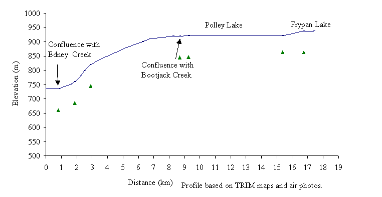
Figure 22. Gradient profile of Hazeltine Creek with eight reaches delineated by triangles.
Photo 12. A portion of the riparian area in reach 1 of Hazeltine Creek has been removed.
Forest Service Recreation sites lie on the southeastern end of Polley Lake and along Edney Creek. An extensive road network exists in the Hazeltine Creek sub-basin, with roads along both sides of Polley Lake and Bootjack Lake. Mount Polley Mine is located between Polley Lake and Bootjack Lake and has improved the access into the sub-basin. A water storage and tailings pond near Polley Lake was developed for the Mount Polley Mine in 1996 (Photo 13; pers. comm. M. Lauret, 1998).
Habitat condition and preliminary assessment
Eight reaches are delineated by the gradient profile of Hazeltine Creek. The Habitat Condition Summary Form in Appendix C7 provides a general description of the stream habitat conditions. Habitat concerns on Hazeltine Creek include seasonal low water flows, industrial development from Mount Polley Mine and extensive forest harvesting to the creek banks. Table 14 provides a brief summary of the potential impacts in each stream, assigned priority for Level 1 assessment, and preliminary restoration opportunities.
Table 14. Preliminary assessment of environmental impacts, priority for Level 1 work and restoration opportunities on Hazeltine Creek (Bucket Area 463).
|
Sub-basin |
Reach |
Channel |
Channel |
Habitat |
Upslope |
Potential Impacts |
Priority‡ |
Restoration |
|
Name |
Num. |
Type* |
Stability† |
Value‡ |
Impact‡ |
|
|
Opportunities |
|
Hazeltine
160-5857 |
1 |
RPgw |
D |
H |
M |
Harvesting in to the riparian area. |
H |
Re-vegetation of riparian area. |
| |
2 |
RPgw |
D |
H |
M |
Road-related migration barriers. |
M |
Crossing modifications if required. |
| |
5 |
RPgw |
S |
H |
M |
Road-related migration barriers. |
M |
Crossing modifications if required. |
| |
7 |
RPgw |
S |
H |
M |
Road-related migration barriers. |
M |
Crossing modifications if required. |
| |
|
Edney
|
1 |
CPcw |
D |
H |
M |
Harvesting into the riparian area. |
H |
Re-vegetation of riparian area, if necessary. |
|
160-5857-038 |
2 |
CPcw |
S |
H |
M |
Road-related migration barriers. |
H |
Crossing modifications if required. |
| |
4 |
RPgw |
S |
M |
M |
Road-related migration barriers. |
M |
Crossing modifications if required. |
| |
6
|
RPgw |
S |
M |
M |
Road-related migration barriers, harvesting into the riparian area |
M |
Crossing modifications if required; re-vegetation of riparian area, if necessary. |
| |
|
Bootjack
160-5857-487 |
1 |
RPgw |
S |
H |
M |
Road-related migration barriers, harvesting into riparian areas. |
M |
Crossing modifications if required; re-vegetation of riparian area, if necessary. |
| |
2 |
CPb |
D |
H |
H |
Eroding banks due to R.O.W. clearing; dam at end of reach. |
H |
Re-vegetation riparian area. |
The following briefly describes areas of concern on Hazeltine Creek on a reach basis. The first two reaches of Hazeltine Creek meander through a narrow floodplain characterized by riffle pool habitat containing some debris and cobble. Edney Creek joins Hazeltine Creek 1 km upstream at the end of reach 1. The riparian area of reach 1 of Hazeltine Creek should be assessed, as it appears to lack a management zone. Reach 2 has a stream crossing that may impede fish migration. The gradient of Hazeltine Creek increases in reaches 3 and 4 and the channel becomes a boulder-step-pool habitat type. Bootjack Creek joins Hazeltine Creek at the end of reach 4 approximately 8.5 km from the confluence of Hazeltine Creek and Quesnel Lake. In reach 5 the creek flows through a shallow, channeled area that extends from Polley Lake (pers. comm., M. Parker, 1998). The stream crossing in reach 5 should be assessed for impacts on fish habitat. Reaches 6 and 8 are composed of Polley Lake and Frypan Lake, respectively. The meandering channel that forms reach 7 contains a few beaver dams along its length.
Photo 13. Mount Polley Mine storage and tailings area. A water pipeline follows the roadside. The photograph shows Bootjack Lake in the distance.
The first reach of Edney Creek is impacted by the cutblock that extends from the first reach of Hazeltine Creek. From the 1:15,000 air photos, it appears that timber in the riparian area has been harvested to the edge of the creek. A road crossing the creek in reach 1 should be assessed for fish accessibility. Stream crossings in reaches 3, and 6 should be assessed for fish passage. Cutblocks in the headwaters of Edney Creek, in reach 6, have been harvested to the stream banks.
The channel of Bootjack Creek is characterized by riffles and pools with some gravel and cobble. A stream crossing in reach 1 of Bootjack Creek is located near the junction with Hazeltine Creek. It should be assessed to determine if it is affecting fish habitat. In reach 2, there appears to be a right-of-way or removal of the riparian vegetation along Bootjack Creek. The lack of riparian vegetation has encouraged the bare upslope areas to erode and aggrade the creek bed (Photo 14). This site should be assessed to determine if the upslope areas could be stabilized. Photo 14 also shows an artificial barrier that maintains the water flow from Bootjack Lake toward the Morehead Creek drainage. Drainage patterns in Bootjack Creek have been altered by development activities about 90 years ago (M. Lauret, pers. comm. 1998). The dam was constructed to provide water for mining activity in the Morehead Creek drainage. Water flow from Bootjack Lake drains toward Morehead Creek sub-basin via a dredged channel. Bootjack Lake now forms the headwaters of Morehead Creek, while spring waters form Bootjack Creek. Both systems support rainbow trout.
Possible habitat restoration opportunities in the Hazeltine Creek include modification of the culverts and re-vegetation of riparian areas along Hazeltine, Edney, and Bootjack creeks.
Recommendations
- Conduct a Level 1 assessment in Hazeltine Creek in reaches 1 and 2, Edney Creek in reach 1 and Bootjack Creek in reaches 1 and 2;
- Conduct a fisheries inventory of Edney Creek upstream of reach 4;
- Assess all stream crossings in the Hazeltine Creek sub-basin.
Photo 14. A dam and clearcut riparian area in reach 2 of Bootjack Creek near Bootjack Lake. Bootjack Creek flows from bottom to top of the photograph.
Bucket Number 465
Spusks Creek
Sub-basin area
The Spusks Creek (160-7212) sub-basin forms Bucket 465. Spusk Creek flows northwest into Quesnel Lake on the southern shore, 41 km from the outlet of Quesnel Lake (Figure 23). The creek has a mainstem length of 16 km with eight reaches delineated in the gradient profile (Figure 24). The data for the profile and delineation produced by G3 Consulting Ltd. (September 1997) was unavailable for incorporation into this report. They delineated 10 reaches from ground truthing during the Level 1 field survey of Spusks Creek. Spusks Creek sub-basin drains an area of approximately 88 km2. Spusks Creek flows through a series of low gradient wetlands, lakes and low rolling hills. Keno, Hen Ingram and Jacques lakes are the major water bodies in the watershed. Hen Ingram Lake and Jacques Lake drain into Keno Lake via Hen Ingram Creek (160-7212-545). Jacques Creek (160-7212-545-010) flows into Hen Ingram Creek a few meters upstream of the confluence of Hen Ingram Creek and Keno Lake.
Fish use
Rainbow trout, largescale suckers and redside shiners reside throughout Spusks Creek and the major lakes (FISS, 1994; G3 Consulting Ltd., 1997; Appendix B8). The wetlands and streams offer potential rearing habitat for fish. Stream cleaning has historically taken place on Hen Ingram Creek and Jacques Creek. Beaver dam removal has occurred in the upper reaches of Jacques Creek. Wetlands and ponds formed by beaver activity may limit access by certain species of fish to the upper reaches of this stream, although access may be possible at higher water flows. However, the off-channel habitats in the wetland areas and ponds associated with beaver dams offer rearing habitat for fish.
Figure 23. Spusks Creek sub-basin is located on the south shore of Quesnel Lake. Fish distribution is based on the Overview assessment.
Forestry and Resource use
Forestry-related activities have taken place throughout the watershed in the 1970’s and 1980’s, resulting in approximately 13 cutblocks (pers. obs., 1998). No logging activities occurred adjacent to stream banks (G3 Consulting Ltd., 1997). G3 Consulting Ltd. (1997) assessed the fish habitat conditions and concluded that restoration or rehabilitation of fish habitat was not necessary. They felt that logging and road building were not causing any negative disturbances to fish habitat.
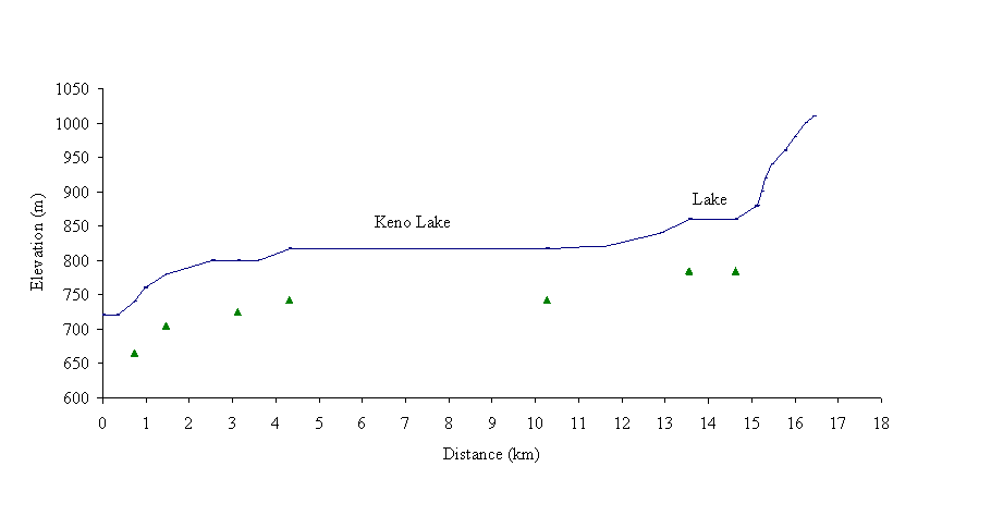 Figure
24. Gradient profile of Spusks Creek with eight reaches delineated by triangles.
Figure
24. Gradient profile of Spusks Creek with eight reaches delineated by triangles.
The road network and an airstrip in this watershed were developed for industrial, public and recreational access from the town of Horsefly. A barge-landing site, near the confluence of Spusks Creek and Quesnel Lake, provides access to the other areas of Quesnel Lake. An airstrip is located near the mouth of Spusks Creek. Roads to each major lake of the watershed and to the shores of Quesnel Lake offer access for standard cars into Forest Services Recreational Sites and several lodging facilities. The B.C. Ministry of Forests has also constructed a recreational area and campsite on the eastern end of Hen Ingram Lake (Photo 15). The recreational developments in reach 1 of Spusks Creek have influenced the streamside vegetation and canopy cover.
Photo 15. A Forest Service Recreational Site (on the lower left) is located on the eastern end of Hen Ingram Lake. The cutblock on the southern shoreline of the lake lacks mature trees in the riparian area. Horsefly Lake is in the distance.
Habitat condition and preliminary assessment
Eight reaches were delineated from the gradient profile of Spusks Creek (Figure 24). The Habitat Condition Summary Form in Appendix C8 provides a general description of the stream habitat conditions. Habitat concerns on Spusks Creek include culverts, beaver-related constructions and removal of riparian timber. The low relief of this sub-basin limits the impacts of forest harvesting. Table 15 provides a brief summary of the potential impacts, assigned priority for Level 1 assessment and preliminary restoration opportunities.
Table 15. Preliminary assessment of environmental impacts, priority for Level 1 work and restoration opportunities in Spusks Creek (Bucket Area 465).
|
Sub-basin |
Reach |
Channel |
Channel |
Habitat |
Upslope |
Potential Impacts |
Priority‡ |
Restoration |
|
Name |
Num. |
Type* |
Stability† |
Value‡ |
Impact‡ |
|
|
Opportunities |
|
Spusks
|
1 |
L/RPgw |
S |
H |
L |
Road-related migration barrier. |
L |
Crossing modification if required. |
|
160-7212 |
4
6 |
RPcw |
S |
H |
L |
Road-related migration barrier and sediment generation. |
L |
Crossing modification if required. |
| |
|
Hen Ingram Creek
|
1
|
RPgw |
S |
M |
L |
Road-related migration barrier. |
L |
Crossing modification if required. |
|
160-7212-545 |
2
3
4 |
RPgw |
S |
M |
L |
Beaver dams and road related migration barrier |
L |
Crossing modification if required |
| |
5 |
RPgw |
S |
M |
L |
Harvesting in the riparian area. |
L |
Re-vegetation if required. |
| |
|
Jacques Creek
160-7212-545-010 |
2
4 |
U |
S |
M |
L |
Road-related migration barrier. |
L |
Crossing modification if required. |
The following briefly describes areas of concern on Spusks Creek on a reach basis. A broad channel forms reach 1 of Spusks Creek where it enters Quesnel Lake. The upper section of reach 1 has a meandering channel with cobble substrate and large woody debris. Sediment and debris from the bridge crossing in reach 1 may be impacting the creek (Photo 16). The channel morphology in reach 2 could not be determined due to overhanging vegetation, although a gradient barrier in reach 2 may prevent upstream migration of fish species from Quesnel Lake. Spusks Creek flows over cascades in reach 3 and contains some large woody debris. In reach 4, the creek is characterized by meandering pool and riffle habitat. The road crossing over Spusks Creek near Keno Lake in reach 4 may be a migration barrier and introduce debris and sediment into the creek. The stream crossing should be assessed as a migration barrier and for sediment generation. The channel meanders in reaches 6 as flows from a small lake. In reach 8 the gradient of the creek increases to approximately 25% and may limit fish access.
In reach 1 of Hen Ingram Creek, a mainline road that crosses the creek should be assessed for fish passage. Beaver dams may block fish migration in reaches 2 to 4 (G3 Consulting Ltd., 1997). In reach 5, Hen Ingram Lake, extensive historic and more recent logging activities combined with an elaborate road system have impacted the riparian vegetation along the lakeshore. Culverts on roads that cross over Jacques Creek in reaches 2 and 4 may restrict fish migration, if water flow is limited, and should be assessed.
Photo 16. Quesnel Lake joins with reach 1 of Spusks Creek forming a basin.
Possible habitat restoration opportunities in the Spusks Creek sub-basin include the modification of the culverts and the re-vegetation of the stream banks.
RecommendAtions
- Conduct a Fish Passage Culvert Inspection on the Spusks Creek sub-basin;
- Conduct a riparian assessment of the southern shoreline of Hen Ingram Lake.
Bucket Number 469
Grain Creek
Sub-basin area
The Grain Creek (160-7327) sub-basin forms Bucket 469. Grain Creek flows east into the North Arm of Quesnel Lake, 52 km from the Quesnel Lake outlet (Figure 25). The creek has a mainstem length of 24 km with 15 reaches delineated by the gradient profile (Figure 26). This is similar to the reaches delineated by Cariboo Envirotech Ltd. (1997b). Since fish cannot access above the falls in reach 9; this fish habitat assessment discusses the first nine reaches. Grain Creek cascades from elevations of 1800 m to Quesnel Lake. At the confluence with Quesnel Lake, Grain Creek forms a delta that is approximately 2 km in length.
Fish use
Sockeye salmon spawn in reach 1 of Grain Creek (FISS, 1994; Appendix B9). Rainbow and bull trout use the lowest 18 km of the creek (Cariboo Envirotech Ltd., 1997b). Waterfalls above reach 9 impede upstream access; the height of the waterfall is less than 20 m.
Forestry use
Forest harvesting in the Grain Creek sub-basin has occurred in the 1990’s. Three of the 10 cutblocks in the sub-basin appear to impact the creek bed either through harvesting in riparian areas (Photo 17) or road building (pers. obs., 1998).
Figure 25. Fish distribution based on Overview assessment of Grain Creek (Bucket 469).
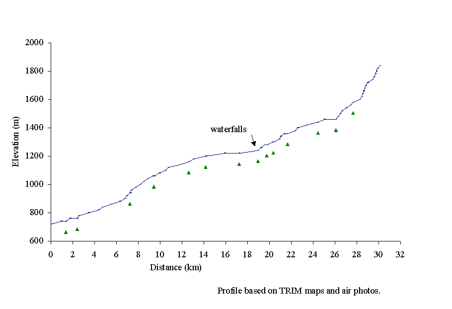
Figure 26. Gradient profile of Grain Creek with 15 reaches delineated by triangles.
Habitat condition and preliminary assessment
Fifteen reaches were delineated in the gradient profile of Grain Creek, based on data from Cariboo Envirotech Ltd. (1997b). The Habitat Condition Summary Form in Appendix C9 provides a general description of the stream habitat conditions. Habitat concerns on Grain Creek include sediment generation from forest harvesting and access roads. Table 16 provides a brief summary of the potential impacts, assigned priority for Level 1 assessment and preliminary restoration opportunities.
The following briefly describes areas of concern in Grain Creek on a reach basis. A meandering channel with riffles and pools characterizes reach 1 of the creek. The abundance of gravel indicates that reach 1 contains spawning habitat for sockeye salmon. The delta fan seen in this reach also indicates increased sediment storage, likely from upstream sediment generation. The gradient of Grain Creek increases throughout reaches 2 and 3, with the channel composed of cascade and pool habitat with a few pieces of woody debris.
Table 16. Preliminary assessment of environmental impacts, priority for Level 1 work and restoration opportunities in Grain Creek (Bucket Area 469).
|
Reach |
Channel |
Channel |
Habitat |
Upslope |
Potential Impacts |
Priority‡ |
Restoration |
|
Num. |
Type* |
Stability† |
Value‡ |
Impact‡ |
|
|
Opportunities |
|
1
2
3
4
6 |
RPgw |
A |
H |
M |
Upstream sources of sedimentation |
H |
Assess upstream areas. |
|
5 |
CPcw |
S |
H |
H |
Harvesting in the riparian area; road-related migration barrier |
H |
Crossing modification if necessary; re-vegetation, if necessary. |
|
7 |
CPcw |
S |
H |
H |
Harvesting in the riparian area; road-related migration barrier |
H |
Crossing modification if necessary; re-vegetation if required. |
|
8 |
CPb |
S |
H |
H |
Harvesting in the riparian area. |
H |
Re-vegetation, if necessary. |
Boulders and some woody debris characterize reaches 4 through 6. In reaches 5, 7 and 8, harvesting has occurred in the riparian area (Photo 17). Potential sediment and debris input from the cutblock areas should be investigated. Road access to the north side of Grain Creek occurs in reaches 5 and 7. The two crossings should be assessed for potential impacts on fish habitat. In reach 7 the gradient of the creek decreases, with the channel composed of pool and riffle habitat. Reach 8 consists of a series of cascades that flow from reach 9 where a waterfall exists. The waterfall in reach 9, height less than 20 m, prevents upstream fish passage (Cariboo Envirotech Ltd., 1997b).
Photo 17. The cutblock in reach 5 of Grain Creek has been harvested to the stream bank.
Possible habitat restoration opportunities in Grain Creek include the re-vegetation of riparian areas.
Recommendations
- Conduct a Fish Passage Culvert Inspection;
- Conduct a Level 1 assessment in reaches 1 through 8;
- Conduct a riparian assessment in reaches 5, 7, and 8 of Grain Creek.
Bucket Number 467
Wasko Creek
Sub-basin area
The Wasko Creek (160-7451) sub-basin forms Bucket 467. Wasko Creek flows westward into Quesnel Lake on its eastern shore, 49 km from the outlet of Quesnel Lake (Figure 27). The creek has a mainstem length of 20 km with 10 reaches delineated in the gradient profile (Figure 28). The lower, middle and upper Wasko Lakes form a nearly continuous sub-basin, which is surrounded by steep slopes. An unnamed secondary tributary (160-7451-031) connects on the north side of Wasko Creek about 1 km upstream of the Quesnel Lake confluence. Wasko Creek has relatively severe winter low flows (Rood and Hamilton, 1990), as lower Wasko Lake is relatively shallow (pers. comm., J. Quigley, 1997).
Fish Use
According to FISS (1994), sockeye salmon spawn in reaches 1, 2 and 3 of Wasko Creek. Kokanee salmon also spawn in reaches 1 and 2 (Appendix B10). Burbot are documented in the Wasko sub-basin up to the junction with the unnamed tributary. Rainbow trout reside throughout middle and lower Wasko Lakes. Non-game fish such as northern squawfish, suckers and whitefish are also documented reaches 1 and 2 of Wasko Creek.
Figure 27. Fish distribution based on the Overview assessment of Wasko Creek (Bucket No. 467).
Forestry and Resource use
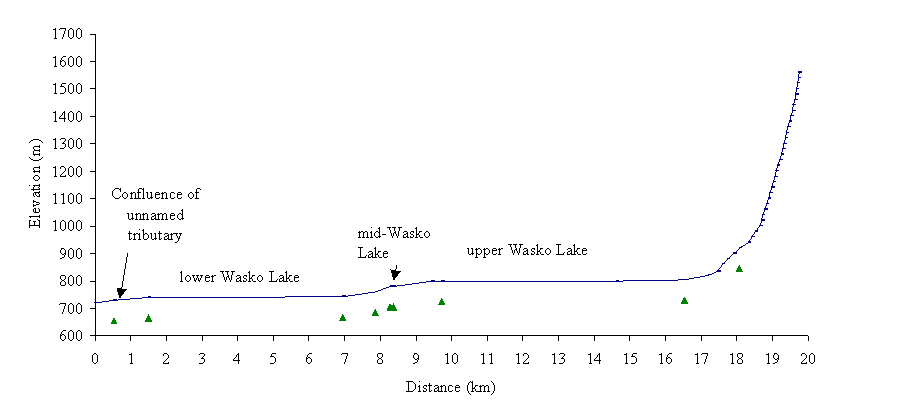 Logging
during the 1960’s occurred along the south banks and upslope areas of reaches
1 through 5, resulting in approximately 30 cutblocks (pers. obs., 1998). There
appears to be few impacts on fish habitat from this activity. Logging in the
1990’s clearcut an area along the northern shore of lower Wasko Lake (Photo
18) and maintained a buffer of riparian vegetation along the shoreline. Recent
logging has also cleared three cutblocks along the unnamed tributary of Wasko
Creek. Historical mining activity has occurred along the unnamed second-order
tributary that flows into the first reach of Wasko Creek.
Logging
during the 1960’s occurred along the south banks and upslope areas of reaches
1 through 5, resulting in approximately 30 cutblocks (pers. obs., 1998). There
appears to be few impacts on fish habitat from this activity. Logging in the
1990’s clearcut an area along the northern shore of lower Wasko Lake (Photo
18) and maintained a buffer of riparian vegetation along the shoreline. Recent
logging has also cleared three cutblocks along the unnamed tributary of Wasko
Creek. Historical mining activity has occurred along the unnamed second-order
tributary that flows into the first reach of Wasko Creek.
Figure 28. Gradient profile of Wasko Creek delineated into 10 reaches by triangles.
Habitat condition and preliminary assessment
Ten reaches were delineated in the gradient profile (Figure 28). Habitat concerns on Wasko Creek include seasonal low flows, warm lake temperatures in the summer and sediment generation from upslope areas on the unnamed tributary. The Habitat Condition Summary Form in Appendix C10 provides a general description of the stream habitat conditions. Table 17 provides a brief summary of the potential impacts, assigned priority for Level 1 assessment and preliminary restoration opportunities.
Table 17. Preliminary assessment of environmental impacts, priority for Level 1 work and restoration opportunities in Wasko Creek (Bucket Area 467).
|
Sub-basin |
Reach |
Channel |
Channel |
Habitat |
Upslope |
Potential Impacts |
Priority‡ |
Restoration |
|
Name |
Num. |
Type* |
Stability† |
Value‡ |
Impact‡ |
|
|
Opportunities |
|
Wasko |
1 |
CPcw |
S |
H |
H |
Road-related migration barrier on tributary; mining related sediment generation. |
H |
Crossing modification if required; re-vegetation if necessary. |
|
Unnamed tributary |
|
|
A |
H |
H |
Road and mining related sediment generation and migration barrier. |
H |
Crossing modification if required |
The following briefly describes areas of concern on Wasko Creek on a reach basis. The channel in reaches 1 and 2 meanders within a broad flood plain and contains some LWD with cobble substrate. The confluence of an unnamed tributary divides reaches 1 and 2. Reach 1 of Wasko Creek is vulnerable to sediment and debris transported from the unnamed tributary. The western slope of the unnamed tributary has an unstable, historical mining area and roads. There are two road crossings in its upper sections.
Photo 18. Harvested block on lower Wasko Lake. Reach 2 is in the foreground.
Habitat restoration opportunities on Wasko Creek area include rehabilitation activities on the unnamed tributary.
Recommendations
- Conduct a fisheries inventory upstream of reach 3 of Wasko Creek;
- Conduct a Level 1 assessment of reach 1 of Wasko Creek and the unnamed tributary.
Summary of recommendations for priority level 1 assessments
The width and depth of the mainstem of the Quesnel River makes it unsuitable for Level 1 survey work. However, the river provides important habitat for several fish species and should be considered a vulnerable area. The sub-basins assessed are presented in the following table with reaches recommended for high and medium priority field examination. High priority reaches are those having high value fish habitat and adjacent or upstream development that has potential affected fish habitat. Medium priority reaches are those that met the above criteria but which have a lower fish habitat value. Since the impacted areas are identified from this office-based Overview, field verification is necessary to confirm recommendations. Priority assignments may be re-evaluated upon field visitation. If the priority drops additional (low priority) sites should be evaluated as time permits.
Table 18. Summary of reaches recommended for high and moderate priority Level 1 FHAP.
|
Sub-basin |
Reach |
Potential Impacts |
Restoration Opportunities |
Species |
Priority |
|
Bucket 484 |
|
|
|
|
|
|
Dragon Creek
160-0017 |
1 |
Road-related migration barriers; eroding banks adjacent to access road. |
Crossing modifications if required; bank stabilisation and road/trail decommissioning. |
RB |
M |
| |
2 |
Road-related migration barrier; log jam affecting fish access; dam at lake outlet |
Crossing modification if required; removal of logjam. |
RB
suspected |
M |
| |
3 |
Dam at lake outlet; water quality related effects. |
Modify flow regulation; restore upstream access for fish. |
RB
|
M |
| |
4 |
Road-related migration barrier; harvested riparian areas. |
Crossing modification if required. |
RB |
H |
|
Barlow
160-0244 |
4 |
Road and railway related migration barrier; hydroline related impacts on riparian vegetation. |
Crossing modification if required. |
RB
suspected |
H |
|
Bucket 464a |
|
|
|
|
|
|
Sardine Creek
160-1829 |
1 |
Road-related migration barrier; restricted side channel development. |
Crossing modification if required; assess potential for side channel development. |
CH, RB |
H |
|
Bucket 466 |
|
|
|
|
|
|
Morehead Creek
160-4155 |
1 |
Road-related migration barrier; truck in creek bed. |
Crossing modification if required; remove truck. |
CH, RB |
H |
| |
2 |
Historical mining related disturbances |
Re-vegetate if necessary. |
U |
H |
| |
4 |
Road and hydro dam construction related sedimentation. |
Assess construction activities and road access to the creek. |
U |
H |
| |
5 |
The concrete armoured culvert migration barrier. |
Crossing modification if required. |
RB |
H |
| |
7
8
9
10 |
Road-related migration barriers; harvesting into riparian areas |
Crossing modification if required; re-vegetation if necessary. |
RB |
H |
|
Bucket 474 |
|
|
|
|
|
|
Maud Creek
160-4401 |
1 |
Harvesting to stream bank |
Re-vegetate riparian area. |
RB |
H |
| |
4 |
Harvesting to stream bank; road-related migration barrier |
Re-vegetate riparian area;crossing modification if required |
RB |
H |
|
Bucket 464b |
|
|
|
|
|
|
Whiffle Creek
160-6724 |
3 |
Harvesting to stream bank; road-related migration barrier |
Re-vegetate riparian area; crossing modification if required. |
RB |
M |
| |
7
8
9
10
11 |
Harvesting to stream bank; road-related migration barrier. |
Re-vegetate riparian area; crossing modification if required. |
RB
suspected |
M |
|
Abbott Creek
160-7068 |
1 |
Harvesting into the riparian area. |
Re-vegetation of riparian area. |
RB |
H |
| |
3 |
Harvesting to stream bank; road-related migration barrier. |
Re-vegetate riparian area; crossing modification if required |
RB |
H |
|
Bootjack Creek
160-5857-487 |
1 |
Road-related migration barriers. |
Crossing modification if required. |
RB |
M |
| |
2 |
Eroding bank due to R.O.W. clearing. |
Re-vegetation of stream bank and riparian area. |
RB |
M |
|
Bucket 463 |
|
|
|
|
|
|
Hazeltine Creek |
1 |
Harvesting into the riparian area. |
Re-vegetation of riparian area. |
RB,SK |
H |
|
160-5857 |
2
5
7 |
Road-related migration barriers. |
Crossing modification if required. |
RB |
M |
|
Edney Creek
160-5857-038 |
1 |
Harvesting in to the riparian area. |
Re-vegetation of riparian area. |
RB, SK |
H |
| |
2 |
Road-related migration barriers. |
Crossing modification if required. |
RB, SK |
H |
| |
4 |
Road-related migration barriers. |
Crossing modification if required. |
RB |
M |
| |
6 |
Harvesting to stream bank; road-related migration barrier. |
Re-vegetate riparian area; crossing modification if required. |
RB suspected |
M |
|
Bucket 469 |
|
|
|
|
|
|
Grain Creek
160-7327 |
1
2
3
4
6 |
Upstream source of sediment. |
Appropriate restoration techniques, as necessary. |
SK, RB |
H |
| |
5
7 |
Harvesting to stream bank; road-related migration barrier. |
Re-vegetate riparian area; crossing modification if required. |
RB |
H |
| |
8 |
Harvesting into the riparian area. |
Re-vegetate riparian area. |
RB |
H |
|
Bucket 467 |
|
|
|
|
|
|
Wasko Creek
160-7451 |
1
|
Road-related migration barriers sediment generation from tributary. |
Crossing modification if required. |
RB, SK |
H |
|
Unnamed tributary
160-7450-031 |
|
Road-related migration barriers; historical mining related sedimentation. |
Crossing modification if required; re-vegetation if necessary. |
RB
suspected |
H |
The following table summarizes the time estimated to assess the reaches recommended as high and moderate priority for Level 1 assessment. Priority assignments may be re-evaluated upon field visitation; if the priority drops other sites should be evaluated as time permits. The time necessary for travel into each sub-basin has not been included and must be taken into account.
Table 19. Level 1 FHAP Plan separated into high and moderate priority assessments.
|
Sub-basin name |
Reach |
Length (km) |
Estimated days
to complete |
|
Bucket 484 |
|
|
|
|
Dragon Creek |
4 |
6.2 |
3 |
|
Barlow Creek |
4 |
3.6 |
2 |
|
Bucket 464a |
|
|
|
|
Sardine Creek |
1 |
1.2 |
0.5 |
|
Bucket 466 |
|
|
|
|
Morehead Creek |
1, 2, 3, 4, 5, 7, 8, 9, 10 |
18 |
9 |
|
Bucket 474 |
|
|
|
|
Maud Creek |
1, 4 |
9.8 |
5 |
|
Bucket 464b |
|
|
|
|
Abbott Creek |
1, 3 |
1.4 |
1 |
|
Bucket 463 |
|
|
|
|
Hazeltine Creek |
1 |
0.8 |
0.5 |
|
Edney Creek |
1, 2 |
7.6 |
4 |
|
Bucket 469 |
|
|
|
|
Grain Creek |
1, 2, 3, 4, 5, 6, 7,8 |
18 |
9 |
|
Bucket 467 |
|
|
|
|
Wasko Creek |
1 |
0.5 |
0.5 |
| |
|
|
|
|
Total for high priority assessments |
66 km |
33 days |
Table 19 (continued).
|
Sub-basin name |
Reach |
Length (km) |
Estimated days
to complete |
|
Bucket 484 |
|
|
|
|
Dragon Creek |
1, 2, 3 |
7.0 |
3.5 |
|
Bucket 466 |
|
|
|
|
Morehead Creek |
11 |
4.0 |
2 |
|
Bucket 464b |
|
|
|
|
Whiffle Creek |
3 |
3.0 |
1.5 |
|
Whiffle Creek |
7, 8, 9, 10, 11 |
3.0 |
1.5 |
|
Bucket 463 |
|
|
|
|
Hazeltine Creek |
2, 5, 7 |
7.6 |
4 |
|
Edney Creek |
4, 6 |
1.1 |
0.5 |
|
Bootjack Creek |
1, 2 |
2.8 |
1.5 |
| |
|
|
|
|
Total for medium priority assessments |
53 km |
27 days |
| |
|
|
|
|
Total |
118 km |
60 days |
References
Anonymous. 1997. British Columbia Conservation Data Center Species List from http://www.env.gov.bc.ca/cdc/
Anonymous. 1995. Fish-Stream Identification Guidebook. Co-published by B.C. Environment and Ministry of Forests. 39p.
Cariboo Envirotech Ltd. 1997a. A draft report of the fish stream inventory and preliminary riparian classification (Forest Practices Code of British Columbia) for Abbott Creek. Prepared for Ministry of Environment Land and Parks by Cariboo Envirotech Ltd. – Integrated Natural Resource Consultants, Likely, BC, under Cariboo Stream Inventory CC6151-IN.
Cariboo Envirotech Ltd. 1997b. A draft report of the fish stream inventory and preliminary riparian classification (Forest Practices Code of British Columbia) for Grain Creek. Prepared for Ministry of Environment Land and Parks by Cariboo Envirotech Ltd. – Integrated Natural Resource Consultants, Likely, BC, under Cariboo Stream Inventory CC6151-IN.
Carmanah Research Ltd. in progress. TFL 52 Fish Inventory. Prepared for West Fraser Mills Ltd. Quesnel Division by Carmanah Research Ltd., Victoria, B.C.
Dolighan, R.B. and M.G. Lirette. 1991. Fisheries assessment of upper Maud Creek, British Columbia. Ministry of Environment, Parks and Lands, Williams Lake, B.C. Regional Fisheries Report. No CA 912. 12 p.
Fish Habitat Inventory and Information Program. 1991. Stream Summary Catalogue. Sub-district 29G Williams Lake. Vancouver, B.C.
Fish Habitat Inventory and Information Program. 1990. Stream Summary Catalogue. Sub-district 29H Quesnel. Vancouver, B.C.
G3 Consulting Ltd. 1997. Quesnel Lake Forest Management Project Watershed Restoration Program – Level 1 Fish habitat assessment draft report. Prepared for West Fraser Mills, Williams Lake Division. March 1997.
Johnston, N.T. and P.A. Slaney. 1996. Fish Habitat Assessment Procedure. Watershed Restoration Technical Circular No.8. Co-published by the Ministry of Environment, Lands and Parks and the Ministry of Forests. p97.
Lamont, C.A. 1991. A review of enhancement opportunities for the Thompson River and Quesnel River drainage basin. Prepared for the Fraser River Environmental Sustainable Development Task Force. 59 p.
Lauret, M. Ministry of Environment, Lands and Parks, Williams Lake. Personal Communication. February 1998.
Lord, T.M. 1984. Soils of the Horsefly Area, British Columbia. Soil Survey Unit, Land Resource Research Institute. Report No. 32. Contribution No. 84-11. p.108 plus maps.
Meidinger, D. and J. Pojar. 1991. Ecosystems of British Columbia. Special Report Series No. 6. Research Branch. Ministry of Forest. Province of British Columbia. p. 330.
Quigley, J. Department of Fisheries and Oceans, Prince George, B.C. Personal Communication. 1997.
Rood, K.M. and R.E. Hamilton. 1995. Hydrology and water use for salmon streams in the Quesnel Habitat Management Area, British Columbia. Can. Manuscr. Rep. Fish. Aquat. Sci. 2296. 138 p.
Rowland D.E. and L.B. MacDonald. 1996. Salmon Watershed Planning Profiles for the Fraser River Basin within the Cariboo-Chilcotin Land Use Plan (CCLUP) area. Prepared for Department of Fisheries and Oceans, Fraser River Action Plan, Vancouver, B.C. and the Habitat Management Unit, Prince George, B.C.
Appendix A General Information on the Quesnel River Watershed Study area
1 Watershed location and tenure information for the Quesnel River
2 Fish species documented to date in the Quesnel River FHAP Study Area
Appendix A1
Watershed location and tenure information for the Quesnel River
|
Watershed name: |
Quesnel River watershed |
|
Gazetteer name: |
Quesnel River |
|
Local names: |
N/A |
NTS 1:50,000 map sheets 93 A/5, A/6, A/11,A/12,A/13, A/14
93 B/8, B/9, B/16
BCGS 1:20,000 map sheets
93 G 008 009
93 G 098 93 B 099 100
93 B 089 090
93 B 079 080 93 A 071 072 074 075
93 B 070 - 93 A 061 062 063 064 065 066
93 A 051 052 053 054 055 056 057
93 A - 042 043 044 045 046 047
|
Hierarchical Watershed Code (HWC): |
160-000 |
|
Stream Mouth UTM Coordinates (zone, easting, northing): |
10. 533879. 5868942 |
|
Stream Order at 1:50,000 map scale |
5 |
|
MOF Region and Districts |
Cariboo Forest Region East |
Quesnel Forest District (#61) |
| |
Williams Lake TSA |
Horsefly Forest District (#63) |
| |
Eastern Williams Lake TSA |
|
Forest Tenure Weldwood of Canada
Riverside Forest Products
West Fraser Mills Ltd.
Nearest community, distance (km), type of access:
City of Quesnel, near the confluence of the Quesnel River and the Fraser River
Granville Ferry, 38 km upstream in Quesnel River, via the Quesnel Hydraulic Road
Quesnel Forks, at junction of the Cariboo and Quesnel Rivers
Likely, at western end of Quesnel Lake, via Likely Road from 150 mile House
Hydraulic, 14 km west of Likely
Horsefly, 75 km northeast of 150 mile House, via Horsefly Road
Several wildlife viewpoints
Mitchell Lake/Niagara Provincial Park (tip of North Arm)
22 British Columbia Forest Service Recreational Sites and 3 BCFS Trails
10 mile Lake and Mouse Heights Provincial Parks
Watershed location (continued)
Bucket no. (area) separation, Named sub-basins, Hierarchical Watershed Codes and Universal Mercator co-ordinates.
|
Bucket no. |
Sub-basin |
HWC |
UTM |
|
|
484 |
Dragon Creek |
160-0017 |
10.538594.5868910 |
Dragon Lake
Hallis Lake |
|
Barlow Creek |
160-0244 |
10.534349.5872678 |
10-Mile Lake |
|
Deacon Creek |
160-1089 |
10.546239.5866374 |
|
|
Cantin Creek |
160-1282 |
10.547301.5862846 |
|
|
Gerimi Creek |
160-1808 |
10.552026.5855104 |
|
|
464a |
Sardine Creek |
160-1829 |
10.552303.5854776 |
|
| |
Towler Creek |
160-2418 |
10.557289.5846566 |
|
|
466 |
Morehead Creek |
160-4155 |
10.580791.5834323 |
Morehead Lake, Bootjack Lake |
| |
Little Lake Creek |
160-4155-127 |
10.581835.5832230 |
Little Lake, Clear Lake |
| |
Warren Creek |
160-4155-294 |
10.580680.5829576 |
|
| |
Trio Creek |
160-4155-689 |
10.588029.5825473 |
Trio Lake |
|
474 |
Maud Creek |
160-4401 |
10.585082.5834367 |
Maud Lake |
| |
Le Bourdais |
160-4401-245 |
10.582954.5841605 |
|
|
464b |
Annette Creek |
160-6416 |
10.613993.5821116 |
Annette Lake, Freshette Lake, Benny Lake |
| |
Whiffle Creek |
160-6724 |
10.618653.5821999 |
Whiffle Lake |
| |
Abbott Creek |
160-7068 |
10.625235.5820679 |
|
|
463 |
Hazeltine Creek |
160-5857 |
10.602023.5817946 |
Polley Lake, Frypan Lake |
| |
Edney Creek |
160-5857-038 |
10.601562.5816999 |
Edney Lake |
| |
Bootjack Creek |
160-5857-487 |
10.595862.5820189 |
|
|
465 |
Spusks Creek |
160-7212 |
10.628090.5821456 |
Keno Lake |
| |
Hen Ingram Creek |
160-7212-545 |
10.632083.5814959 |
Hen Ingram Lake |
| |
Jacques Creek |
160-7212-545-010 |
10.627975.5814730 |
Jacques Lake |
|
469 |
Grain Creek |
160-7327 |
10.634702.5829389 |
|
|
467 |
Wasko Creek |
160-7451 |
10.644213.5823516 |
lower, mid and upper Wasko Lakes |
Appendix A2
Fish species documented to date in the Quesnel River FHAP study area.
|
Common Name |
Scientific Name |
BC Fish Codes |
|
American shad |
Alosa sapidissima |
SH |
|
Bull trout* |
Salvelinus confluentus |
BT |
|
Burbot |
Lota lota |
BB |
|
Chiselmouth* |
Acrocheilus alutaceus |
CM |
|
Chinook salmon |
Oncorhynchus tshawytscha |
CH |
|
Coho salmon |
Oncorhynchus kisutch |
CO |
|
Dace, general |
Rhinichthys sp. |
DC |
|
Dolly Varden |
Salvelinus malma |
DV |
|
Dragon Lake Whitefish* |
Coregonus sp. |
DLW |
|
Kokanee |
Oncorhynchus nerka |
KO |
|
Lake Trout |
Salvelinus namaycush |
LT |
|
Lamprey, general |
Lampetra sp. |
L |
|
Longnose dace |
Rhinichthys cataractae |
LNC |
|
Longnose sucker |
Catostomus catostomus |
LSU |
|
Mountain whitefish |
Prosopium williamsoni |
MW |
|
Northern squawfish |
Ptychocheilus oregonensis |
NSC |
|
Peamouth chub |
Mylocheilus caurinus |
PCC |
|
Pink salmon |
Oncorhynchus gorbuscha |
PK |
|
Rainbow Trout |
Oncorhynchus mykiss |
RB |
|
Redside shiner |
Richardsonius balteatus |
RSC |
|
Sculpin, general |
Cottus sp. |
CC |
|
Sockeye salmon |
Oncorynchus nerka |
SK |
|
Sucker, general |
Catostomus sp. |
SU |
|
White sturgeon* |
Acipenser transmontanus |
WS |
|
Whitefish, general |
Prosopium sp. |
WG |
*Rare species according to British Columbia Data Center (Anon., 1997)
Appendix B Fish Distribution Forms
1 Quesnel River Mainstem
2 Bucket No. 484 a Dragon Creek
b Barlow Creek
c Deacon Creek
d Cantin Creek
e Gerimi Creek
3 Bucket 464a a Sardine Creek
b Towler Creek
4 Bucket No. 466 Morehead Creek
5 Bucket No. 474 Maud Creek
6 Bucket No. 464b a Annette Creek
b Whiffle Creek
c Abbott Creek
7 Bucket No. 463 Hazeltine Creek
8 Bucket No. 465 Spusks Creek
9 Bucket No. 469 Grain Creek
10 Bucket No.467 Wasko Creek
Codes used on tables:
K = known U=unknown or undetermined
K* = spawning
FISS refers to the Fish Information Stream Summary map sheets
UN = unknown
Appendix C Habitat Condition Summary Forms
1 Quesnel River Mainstem
2 Bucket No. 484 a Dragon Creek
b Barlow Creek
c Deacon Creek
d Cantin Creek
e Gerimi Creek
3 Bucket 464a a Sardine Creek
b Towler Creek
4 Bucket No. 466 Morehead Creek
5 Bucket No. 474 Maud Creek
6 Bucket No. 464b a Annette Creek
b Whiffle Creek
c Abbott Creek
7 Bucket No. 463 Hazeltine Creek
8 Bucket No. 465 Spusks Creek
9 Bucket No. 469 Grain Creek
10 Bucket No.467 Wasko Creek
Codes used on tables are provided in Appendix D and in Johnston and Slaney (1996).
Appendix D Habitat Condition Summary Form codes
Wb (m): Mean Bankfull Channel Width in meters.
Channel Type: a generalized descriptor of the overall morphology of the stream channel.
|
Channel Type |
Channel Type Code |
|
Block-Step-Pool |
SPr |
|
Boulder-Step-Pool |
SPb |
|
Debris-Boulder-Step-Pool |
SPbw |
|
Boulder-Cascade-Pool |
CPb |
|
Debris-Cobble-Cascade-Pool |
CPcw |
|
Riffle-Pool |
RPcw |
|
Riffle-Bar-Pool |
RPgw |
|
Pond or small lake |
L |
|
Unknown |
U |
Disturbance Indicators
|
Code |
Indicator Feature |
|
SC |
Bed 1. Extensive areas of scour |
|
DW |
Bed 2. Extensive areas of (unvegetated) bar |
|
WG |
Bed 3. Large, extensive sediment wedges |
|
MB |
Bed 4. Elevated mid-channel bars |
|
LR |
Bed 5. Extensive riffle zones |
|
FP |
Bed 6. Limited pool frequency and extent |
|
MC |
Channel 1. Multiple channels (braiding) |
|
EB |
Banks1. Eroding banks |
|
BC |
Banks 2. Isolated sidechannels or backchannels |
|
PD |
LWD 1. Most LWD parallel to banks |
|
JM |
LWD 2. Recently formed LWD jams |
Barriers
|
BD |
Beaver dams - identified as pools behind a channel-spanning structure of mud and interleaved trees and rocks, usually in low to moderate gradient areas. |
|
BR |
Bridges - road crossings that constrict the channel can be barriers to fish movement |
|
C |
Cascades or chutes - appear as white water in steep channels. |
|
CV |
Culvert - Check the road condition assessment to judge the status of culverts, or examine them directly. |
|
F |
Falls - vertical drops greater than about 2 m. |
|
G |
Gradient barriers - gradients greater than about 20% are often barriers to fish movement. |
|
LS |
Landslides or bank sloughing - unvegetated actively eroding banks or slopes that produce large fans of sediment or abrupt changes in stream course. |
|
N |
No barriers |
|
U |
Unknown. |
|
X |
Log jams - substantial accumulations of logs that completely cover the stream channel. |
Percent Pools
|
0 |
no pools in the section |
|
1 |
1-25% pool by area |
|
2 |
26-50% pool by area |
|
3 |
51-75% pool by area |
|
4 |
76-100% pool by area |
|
9 |
unable to estimate pool area (e.g., because of canopy closure). |
Large Woody Debris (LWD) Amount and Distribution
|
AC |
abundant LWD - clumped distribution of LWD pieces |
|
AE |
abundant LWD - LWD is evenly-distributed along the channel |
|
FC |
few LWD pieces - clumped distribution of LWD pieces |
|
FE |
few LWD pieces - LWD is evenly-distributed along the channel |
|
N |
no LWD |
|
U |
unknown. |
Riparian Type: the composition of the dominant vegetation type immediately adjacent the stream channel (i.e., in the FPC riparian management area, RMA)
|
C |
conifer-dominated riparian forest |
|
D |
deciduous-dominated riparian forest |
|
G |
non-forested grassland or bog (<10% tree cover) |
|
M |
mixed conifer-deciduous riparian forest (>25% conifer and deciduous) |
|
N |
unvegetated. Much bare mineral soil is visible, |
|
S |
shrub/herb. Herbaceous or shrubby vegetation dominate. |
Stand Structure: the structural stage of the dominant vegetation in the RMA
|
INIT |
- the non-vegetated or initial stage following disturbance, with less than 5% cover. |
|
MF |
- mature forest with well-developed understory. Conifer-dominated mature forests (MFc) have greater than 50% conifers in the sub-canopy layers while mixed forests (MFm) have greater than 25% component of both coniferous and deciduous trees in all canopy layers. |
|
PS |
- pole-sapling stage, with trees overtopping the shrub layer, usually less than 15-20 years old. |
|
SHR |
- shrub/herb stage. Less than 10% tree cover. |
|
YF |
- young forest. Self-thinning is evident and the forest canopy is differentiating into distinct layers. Stand age is 30-80 years. |
Canopy Closure (shading): The proportion of the surface area of the stream covered by the riparian canopy
|
1 |
stream surface and banks visible (0-20% shade) |
|
2 |
stream surface and banks visible at times (20-40%) |
|
3 |
stream surface visible but banks are not visible (40-70%) |
|
4 |
stream surface slightly visible or visible in patches (70-90%) |
|
5 |
stream surface not visible (>90% shade) |
Off-channel Fish Habitat: The extent of and access to off-channel fish habitat
|
F |
fair. Little off-channel habitat or poor access for fish. |
|
G |
good. Abundant off-channel habitat with good access for fish. |
|
M |
moderate. Some off-channel habitat with good access for fish. |
|
P |
poor. No off-channel habitat or no access for fish. |
|
U |
unknown. |