Woodjam Creek
Overview Fish Habitat Assessment
(WRP PROJECT #: 102265-A)
Prepared for:
Weldwood of Canada Ltd.
Box 4509
Williams Lake, BC
V2G 2V5
Prepared by:
Westroad Resource Consultants Ltd.
164 Front St.
Quesnel, B.C.
V2J 2K1
Tel: (250) 992-2987
Submitted:
September 1999
With funding provided by Forest Renewal British Columbia (FRBC), Weldwood of Canada Ltd. (Williams Lake Operations) retained Westroad Resource Consultants Ltd. to conduct an Overview Fish Habitat Assessment Procedure (FHAP) of the Woodjam Creek Basin. The primary objective of the assessment was to develop a list of high priority areas that may require rehabilitation activities.
Woodjam Creek is a relatively small 4th-order basin (8,900 ha) of the Horsefly River Watershed. The basin is predominantly forested (96%) with significant agricultural development concentrated on private land along the lower three reaches of the mainstem. These lower reaches are among the highest value fish habitats within the entire basin. Soils in the basin are typically fine-textured and are the basis for much concern over bank erosion and fish habitat degradation.
Historical fish distribution and habitat data exists for the basin although not in abundance. The most recent intensive data collections have occurred as FRBC fish and fish habitat inventories conducted by Bioterra Consulting Ltd. (1998a, b). These inventories have documented the abundance of juvenile chinook (Oncorhyncus tshawytscha) and coho (O. kisutch) salmon and rainbow trout (O. mykiss) in the lower watershed. Rainbow trout have been found in most of the lower reaches of the major tributaries as well as in the mainstem as far up as reach twelve. An older study (Sebastian, 1990) also documented an abundance of juvenile chinook, coho and rainbow in the lower mainstem. Limits to distribution of any species have only been confirmed for the two 3rd-order tributaries draining into the lower Woodjam Creek. Barriers to migration (2.5-metre falls and 2.0-metre cascade) have been confirmed on both these tributaries (Maclean and Cold creeks); no fish were captured upstream of these barriers. Barriers to migration have not been documented elsewhere in the drainage.
Reach break analysis and review of existing literature showed that streams are generally of low gradient; over 85% of stream reaches average less than 10% gradient. Reach break analysis also indicated that channels are dominated by riffle-pool habitats and gravel substrates with over-vegetation and undercut banks providing most cover where it is available. Headwater reaches and small drainages with limited catchment areas are predicted to be non-classifiable drainages.
Although target species for this assessment, as indicated by historical data, are chinook and coho salmon and rainbow trout, general assessments of some of the mid-mainstem reaches (six to twelve) may help to direct rehabilitation efforts at a specific species if barriers to migration can be identified.
Review of forest, road and agriculture-activities/features within the basin identified seventeen sites which warrant further assessment. Five agriculture-related sites are identified in the lower basin. All are situated within the boundaries of the private lots concentrated along the lower reaches of the mainstem. Most noticeable of the impacts was the significant reduction in riparian vegetation lining the mainstem’s lower three reaches. Upslope soil erosion was also identified as a potential concern at two sites. Opportunities exist to stabilize eroding stream banks and re-seed exposed upland soils contributing sediment to the stream network.
Three road-related sites are identified. Concerns stem from the potential for significant sediment delivery as road or ditch run-off directly into Woodjam Creek or one if its small tributaries. The sites should be assessed to determine whether concerns exist and to propose remediation actions.
Six crossing-related sites are identified; all are situated on private land. The crossings are variously used by farm machinery and cattle and may not pose much concern to fish and fish habitat, however, they should be assessed to confirm this. Sites C1, C3 and C4 are crossings of the mainstem and a tributary of Maclean Creek at which crossing structures have not been confirmed. Sites C2, C5 and C6 appear to be ford crossings and may be sources of sediment either as a result of active crossings or because of eroded banks adjacent to the crossings.
Three harvest-related sites are identified. Sites H1 and H2 are sections of creek adjacent to recently logged (post-code) cutblocks. The sites should be examined to confirm that the riparian zones are continuing to function in protecting against stream bank erosion and sediment delivery to lower Woodjam Creek. Site H2 should be checked regularly to monitor the integrity of the steep slope adjacent to the cutblock and creek.
Site H3 encompasses the north and east banks of Woodjam Creek adjacent to a cutblock that was harvested in 1995/96 to pre-Code standards. Potential impacts to the creek may exist where harvesting has occurred to the stream edge. An assessment should examine whether recruitment of large woody debris and vegetation cover have been lost or reduced and whether the integrity of stream banks and instream habitats has been compromised.
Fisheries assessments within the basin should attempt to understand the nature of the rainbow trout population (i.e. resident vs migratory), and whether barriers to migration exist within the mainstem. Rehabilitation priorities should be given to agriculture- and road-related sites as they have the most potential to significantly alter fish habitat or access to it.
EXECUTIVE SUMMARY *
Table of Contents *
1.0 Introduction *
1.1. Study Area *
General *
Access *
Resource Use *
1.2. Existing Fish Presence Information *
2.0 Methods *
2.1. Information Resources *
2.2. Map Features and General Basin Information *
2.3. Basin Delineation and Reach Breaking *
2.4. Identifying Prescription sites *
3.0 Results *
3.1. Fish Species Presence *
3.2. Fish Habitat *
3.3. Reach Break Analysis *
3.4. Prescription Sites *
4.0 Discussion *
4.1. General basin assessments and opportunities *
4.2. Prescription Sites *
Agriculture-Related Sites *
Road-Related Sites *
Crossing-Related Sites *
Harvest-Related sites *
5.0 Conclusions *
6.0 References: *
APPENDIX A: Longitudinal Profiles
APPENDIX B: List of Aerial Photos Used
APPENDIX C: Data Forms
APPENDIX D: Prescription Site Summary Form
APPENDIX E: Project Map
The Watershed Restoration Program’s Fish Habitat Assessment Procedure (FHAP) is a set of three iterative procedures whose ultimate purpose is to develop site-specific prescriptions for degraded or sensitive fish habitats. The Overview FHAP is the broadest of these procedures deriving most results from existing literature, local knowledge and interpretation of air photos and topographic maps.
Weldwood of Canada Ltd. (Williams Lake Operations), with funding provided by Forest Renewal British Columbia (FRBC), retained Westroad Resource Consultants Ltd. (Westroad) to conduct an Overview FHAP of the Woodjam Creek Basin in the Horsefly Forest District. The primary objective of the assessment was to develop a list of high priority areas that may require rehabilitation. Specific objectives of the assessment were:
Woodjam Creek is a relatively small 4th-order tributary of the Horsefly River. It drains 8,900 hectares (ha) of forested and agricultural land ranging in elevation between 825 and 1,505 metres (Figure 1). Nearly 60 percent of the basin is situated at lower elevations within the SBSdw1 and SBPSmk subzones. The remainder is situated within the SBSwk1 and ESSFwk1 subzones at mid and upper elevations. Topography is characterized by level and rolling terrain with slope gradients typically less than 20 percent.
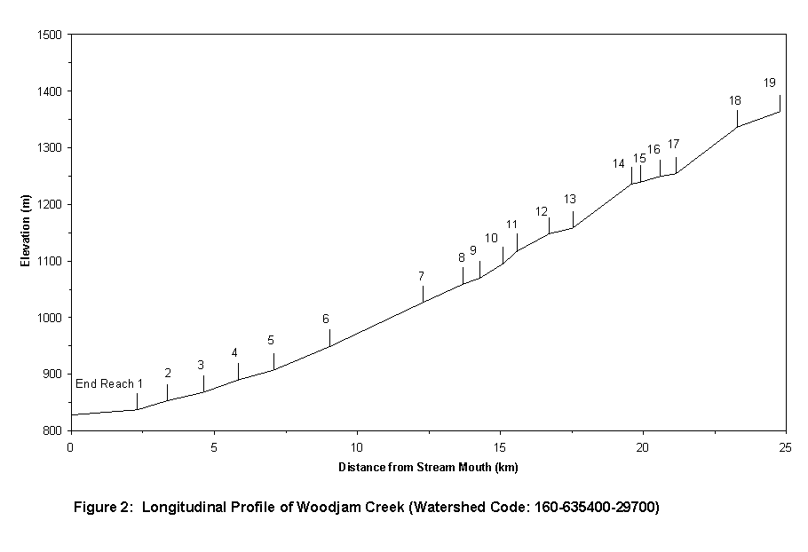
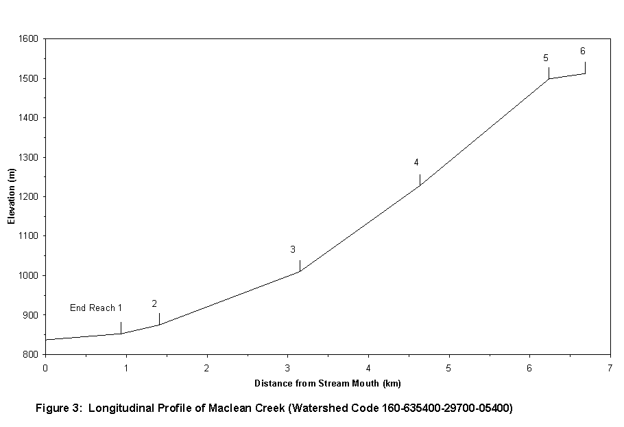
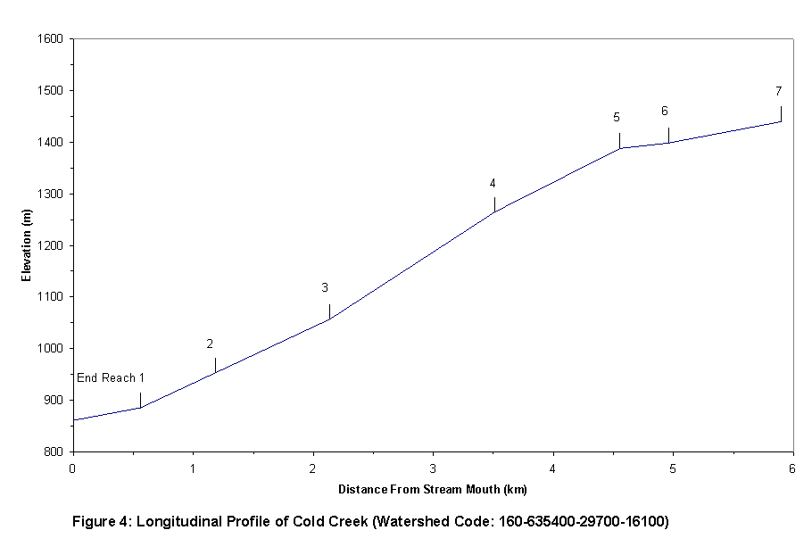
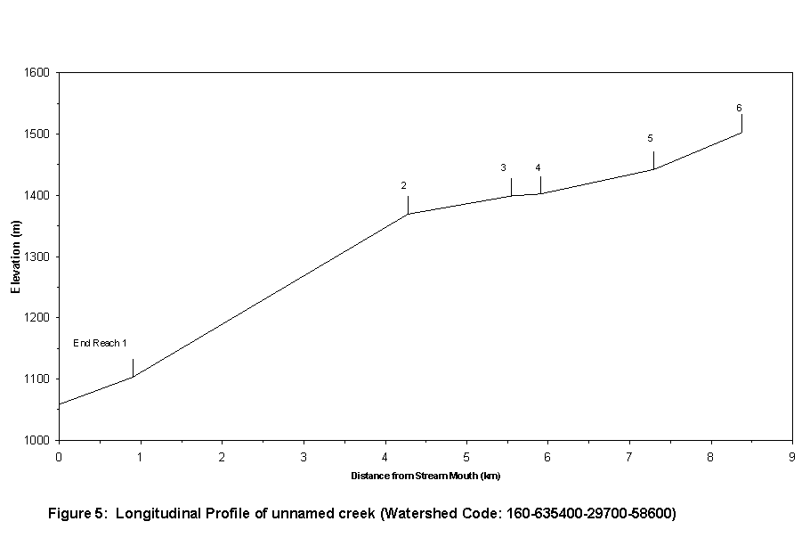
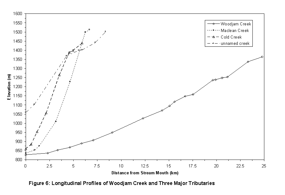
The Woodjam system has three major 3rd-order tributaries. Draining into lower Woodjam Creek are the locally named Maclean (WSC: 160-635400-29700-05400) and Cold (WSC: 160-635400-29700-16100) creeks. The third tributary is unnamed (WSC: 160-635400-29700-58600) and drains into Woodjam at reach eight. At the confluence with this unnamed creek, Woodjam Creek changes from 3rd-order to 4th-order. Longitudinal profiles of each of these tributaries and the mainstem Woodjam are presented in Appendix A (Figures 2-6).
Located east of the town of Horsefly, access to the basin is by two- and four-wheel drive via the Horsefly, Moffat Creek (2300), or Deerhorn roads.
The Woodjam Creek basin is composed of forested crown land (96 percent) and cleared private land (4 percent) used primarily for agriculture (Chapman and Dobson, 1997). The private land is centred on the mainstem channel from the mouth at Horsefly River upstream to reach break 5 (see map -Appendix E). Most of this land has been cleared. Sparse riparian vegetation cover characterizes significant portions of the creek channels within the private lot boundaries.
Current forest conditions within the basin are a result of ongoing harvesting and a historical fire (ca. 1979) that burned much of the area. Licensees operating in the basin include; Weldwood of Canada Ltd. (upper basin), Riverside Forest Products Ltd., Lignum Ltd. (central basin), Ainsworth Lumber Co. Ltd. (lower watershed) and various small business enterprises scattered throughout.
Recently, approvals to harvest numerous blocks in the Woodjam basin have been deferred over concerns the projected rate of cut could potentially create increased peak flows (Lawrence, pers. comm.) and result in degraded fish habitat through stream bank erosion and sediment deposition. This concern is largely based on two factors: the dominance of fine soils throughout the basin, and the general lack of riparian vegetation in the lower reaches (Chapman and Dobson, 1997). Degradation of fish habitat is also of concern where livestock presence can reduce stream bank integrity and trample instream substrates.
Chinook (Oncorhyncus tshawytscha) and coho (O. kisutch) salmon, rainbow trout (O. mykiss), and longnose dace (Rhinichthys cataractae) are known to utilize the Woodjam basin. Historical fish capture sites are documented in Bioterra’s fish inventory reports (1998a, 1998b) and on Fisheries Information Summary System (FISS) map 93A06 (DFO, 1996?). These sites have been annotated onto the accompanying Overview FHAP project map (Appendix E). More specific species distribution information is presented in Section 3.2.
Figure 1: Woodjam Creek Study Area
Several sources of information were utilized for this assessment:
1:15,000 - 1996/95, 1992, 1989, 1969,
1:50,000 - 1998
Weldwood of Canada Ltd.
Riverside Forest Products Ltd.
Ministry of Forests (MOF)
Ernie Schmid (Operations Superintendent - Weldwood of Canada Ltd.)
Frank Kaempf (Area Supervisor - Riverside Forest Products Ltd.)
John Liscomb(Lignum Ltd.)
Don Lawrence (Department of Fisheries and Oceans Habitat Biologist)
Brian Chapman and Rob Dolighan (Fisheries Officers - Min. of Environment)
Wayne Johnson (Range Officer -Horsefly Forest District)
Pat Teti (Research Hydrologist - MOF)
Information relevant to fish distribution and fish habitat conditions was mapped as features on the accompanying project map. Fish distributions were recorded by hand on standard summary forms (Form 1) and then entered into a database using the Ministry of Environment Lands and Parks (MELP) FHAP data entry tool. Computer printouts of the form are presented in Appendix C. The computer-generated form has been modified from the standard format by deleting most of the fish species which are not found in the area.
Forest development plan (FDP) maps and the most recent (1998) series of photos (1:50:000) were used to identify the location of cutblocks and roads. Harvest dates were taken from FDP and TRIM maps and confirmed with licensee representatives. General basin conditions and statistics were taken from the various Horsefly and Woodjam Creek reports, specifically G3 Consulting (1998a, b), Bioterra (1997), Chapman and Dobson (1996, Dobson (1996), NHC (1996), and NHC and CRES (1996).
Fish capture locations from FISS map 93A06 and Bioterra’s fish inventories (1998a, b) were annotated onto the accompanying project map.
Each stream has been uniquely identified with either a watershed code (WSC) (if available) or an interim locational point (ILP). WSCs were taken from the current B.C. Watershed Atlas.
The Woodjam basin boundary was delineated on hardcopy TRIM maps (093A 024, 014). Only the stream network and associated wetlands were included within this study; isolated wetlands were not. Headwater wetlands were also generally excluded unless evidence of a channel or standing water connected to the stream network were visible on air photos.
Reach breaking was carried out using the 1996/95 and 1992 series of aerial photos. Reach breaks were established where significant changes in the following characteristics were observed or predicted:
Stream widths, riparian vegetation, percentage of pools, channel morphology, and LWD class were confirmed with, or modified to correspond with, ground measurements presented in the Bioterra inventory reports (1998a, b). Known fish-passage barriers (falls, chutes) identified by Bioterra have been annotated onto the accompanying FHAP project map.
The Bioterra reports also identify several occurrences of confirmed non-classifiable drainages (NCDs). These occurrences were used as indicators to predict additional occurrences in the drainage during reach break analysis.
Reach characteristics were recorded by hand on the standard FHAP Habitat Condition Summary Form (Form 2) and then entered into an Access database using MELP’s FHAP Data Entry Tool. The Data Entry Tool, generates slightly different form formats, incorporating a unique identifier (detail number) for each entry, UTM coordinates (if entered), channel stability (if entered), and adjacent land use (if entered). Computer printouts of this form are presented in APPENDIX C.
Potential prescription sites were grouped according to adjacent land-use impacts or activities. Agriculture- and harvest-related prescription sites were two such groups. They were identified in aerial photos by locating visibly degraded or potentially degraded stream and riparian conditions. Photos dating back to 1969 were examined. Potential road-impacted sites were located through conversations with licensee representatives and through aerial photo identification of road sections associated with steep terrain directly adjacent to stream channels. Crossing-related sites were identified from air photos as well as by comparison of Bioterra’s fish-passage culvert inspection results (1997) with features visible in the photos.
Three principle sources of fish sampling data were referenced to identify known fish presence within the Woodjam basin. In addition, the locations of two rainbow trout capture sites were provided by Weldwood. These sites were sampled in association with proposed stream crossing installations. The first site is located in Reach 1 of WSC 160-635400-29700-52900. The second is located in Reach 4 of WSC 160-635400-29700-58600-1000.
Bioterra (1998a, b) captured five species of fish - chinook and coho salmon, rainbow trout, longnose dace and an unidentified species. A total of 263 fish were captured at 16 sample sites spread throughout the drainage; mostly within the mainstem and major tributaries. One hundred and fifty-five (155) of these were rainbow trout, 81 were coho, and 20 were chinook. All fish except for one rainbow trout (~140 mm) which was captured in reach three of Maclean Creek, were classed as juveniles.
FISS map 93A06 identifies coho, chinook, rainbow trout, and an unknown sp. as being present within the lower reaches of Woodjam and at the mouth of Maclean Creek. Only one of the six references associated with these occurrences (Sebastian, 1990) could be located.
Sebastian (1990) captured 47 rainbow trout, 130 coho and 36 chinook in a site measuring 62.5-m2. The site is described as being situated in reach 1, approximately half way up its 12-km length. In relation to reach-breaks delineated for this assessment, the site is situated at the upstream end of reach 5 (see project map).
Sebastian (1990) noted that Woodjam Creek had higher combined densities of chinook, coho, and rainbow fry than Moffat and McKinley creeks - two larger tributaries of the Horsefly River. He concluded that Woodjam is "an excellent nursery stream for rainbow and coho" but that "hydraulic suitability for larger fish (e.g. age 2+ and older) is limited by [the creek’s size] (i.e. depth)." The history of fish capture records certainly indicates that the stream is heavily utilized by juveniles of all three salmonid species and that minor occurrences of adult use (possibly including rainbow spawners) are likely.
At the time of survey (22 September, 1987), Sebastian’s (1990) sample site in the lower Woodjam (Reach 5) was characterized by high cover (80% - predominantly over-vegetation), instream substrates dominated by fines and small gravels, and low water velocity (0.07 m/s) and stream discharge (0.02 m2/s). Aerial photo interpretation of current habitat features indicates that riparian conditions have changed little at this site since 1969. Reach breaking analysis predicts channels to be dominated by riffle-pool habitats and gravel substrates.
Bioterra (1998a, b) provided site-specific information for each of its sample sites. Some generalizations about stream and riparian conditions within the Woodjam basin can be made based on these results. Channel morphology is generally characterized by riffle-pool habitats. Gravels tend to dominate in lower gentle reaches, cobbles on slightly steeper reaches (e.g. mainstem reaches 7, 8, 10, 11), and fines in those upper reaches where gradients diminish again. Dominant cover type is typically over-vegetation or undercut banks. In general, total cover is less than 50 percent; at times less than 10 percent. Habitat complexity seems to increase in association with a transition from gravels to cobbles as the dominant substrate. Functional large woody debris tends to be most abundant in these reaches as well. Confirmed barriers to migration on the mainstem were not observed during the Bioterra inventory; however, small falls of 1-metre and less were noted as potential barriers, particularly during low flows. Confirmed barriers were identified on Cold Creek (WSC: 160-635400-29700-161000) at reach break 2 and on Maclean Creek (WSC: 160-635400-29700-05400) within reach 4 (see project map).
A total of 158 reaches were delineated in the Woodjam basin. Seventy-six of these are predicted to be non-classifiable drainages (NCD) based on the minimal catchment areas upslope and as indicated by Bioterra’s (1998b) NCD designations. Most NCDs are situated at headwaters. Where small watercourses drain very small catchments, their entire lengths have been deemed NCDs (e.g. ILPs 011 and 019). NCDs were not subdivided to the scale comparable to stream reaches even if non-homogeneous reach criteria were noted.
Average stream reach length (excluding NCDs) is 1.05-km. Average gradient is 5.6%. Over 85% of stream reaches have gradients less than 10%; only two reaches have average gradients steeper than 20%. Within stream reaches characterized by average gradients of 10% or greater, fish habitat, or access to it, is predicted to be greatly limited by low water levels, occurrences of small falls (up to 1 metre in height), and unsuitable channel morphology. Bioterra (1998a) fish inventory results demonstrate that small falls of 1-m or less may even limit fish distribution in gentle reaches, perhaps due to low water levels during dry periods. Overwintering habitats in upper reaches of tributaries appears to be limited by low water levels in all but the mainstem (perhaps as high as the wetland reach 17) and the lower reaches of the major 3rd-order tributaries.
Sites identified as potential prescription sites have been grouped into four categories:
Road- and crossing-related sites are point locations that are suspected of contributing sediment to the adjacent creek systems. Harvest- and agriculture-related sites generally identify linear sections of stream potentially impacted upon by the respective activity types.
In total, seventeen sites were identified;
|
Category |
Potential Prescription Sites |
|
|
Agriculture-related sites |
A1-5 |
|
|
Road-related sites |
R1-3 |
|
|
Crossing-related sites |
C1-6 |
|
|
Harvest-related sites |
H1-3 |
|
|
Total Sites |
17 |
|
Details for each site, including location, predicted impacts, and potential actions to be taken, are summarized in Appendix D.
Results of this overview assessment indicate that the most common, and economically and culturally important fish species in the Woodjam basin are chinook and coho salmon and rainbow trout. Rehabilitation initiatives should, therefore, target these species. It should be noted however, that the distribution limits for anadramous salmonids and rainbow trout within the Woodjam system have not been definitively identified. Consequently, as chinook or coho have not been captured above reach 6, rehabilitation measures considered for upstream of this point may only benefit rainbow trout.
Reach seven is the first confined reach which fish encounter on moving upstream from the Horsefly River. A falls or major cascade may pose a barrier to upstream migration. In order to prescribe appropriate upstream rehabilitation measures (i.e. in relation to target fish species) it would be useful to first determine whether a barrier(s) exists. Chinook and coho are not likely to seek out rearing habitats upstream of reach six during spring run-off but if suitable spawning habitat exists upstream then adult migration may occur. The likelihood is limited however by the hydraulic conditions of the drainage as noted by Sebastian (1990) and reiterated here in Section 3.2.
Reaches eight, ten, eleven, and twelve are among the steepest reaches on the mainstem with gradients ranging from 2.8% to 4.5%. These reaches may also contain barriers to migration, particularly during periods of low flow. In addition, these steeper, occasionally confined reaches may be contributing fine sediment during peak flows to downstream reaches. Assessing upstream reaches (e.g. Site H3) for rehabilitation opportunities should also include walking these reaches to identify barriers. Additional opportunities to mitigate against bank scour may be found during these walks. No evidence of bank scour was seen in air photos or reported in Bioterra’s fish inventory (1998a) and so no such areas were identified as potential prescription sites.
Highest fish habitat values are concentrated in the Woodjam Creek mainstem (up to Reach 17) and the lower reaches of the three major 3rd-order tributaries (locally named Maclean and Cold creeks and the unnamed 160-635400-29700-52900).
Among the highest value habitats are those within reaches one to five of the mainstem. These low gradient reaches flow through private land and are characterized by gravel-dominated riffle-pool habitats. A comparison of 1969 and 1995/96 photos revealed that the first three reaches have undergone significant changes in morphology over the past thirty years. The change most prominent in the photos is the extensive reduction in the width of the riparian vegetation community. This has presumably occurred because of encroaching agricultural clearing and cattle grazing. In conjunction with the reduction in riparian vegetation, the stream channel and banks become increasingly prone to the effects of cattle trampling and peak stream flows. The ultimate effects of these agriculture-related activities are several:
Five agriculture-related sites have been identified as potential prescription sites. Sites A1 and A2 are point locations at which upslope sediment sources may exist. Narrow riparian vegetation strips are present and potential cattle trampling of banks and instream substrates are also of concern. Sites A3, 4, and 5 are associated with the entire lengths of reaches 1, 2 and 3 respectively. The reaches exhibit significant historical reductions in riparian vegetation, potentially aggraded sections resulting from channel widening and bank erosion, and trampling of instream substrates where cattle have unobstructed access to the stream channel.
These agriculture-related sites should be visited and assessments conducted to determine the following:
Three road-related sites have been identified as potential areas of concern. The concerns are each related to the effects of suspended sediments in road and ditch run-off, particularly during periods of heavy rain and rapid snowmelt. The sites should therefore be assessed at the time when run-off is expected to be highest (perhaps mid-May).
Site R1 was identified in discussion with Frank Kaempf of Riverside Forest Products Ltd. A sump has been excavated to collect water and sediment chronically flowing into Woodjam Creek. The sump is regularly emptied and although no other options for dealing with this chronic sediment source have been proposed, none may be available. This condition apparently existed prior to Riverside moving into the area and as such would likely be a candidate for funding by FRBC.
Site R2 is situated upslope of Site R1 and may be a chronic source of sediment to Woodjam Creek through one of its smaller tributaries (WSC: 160-635400-29700-27400). Any potential sediment delivery concerns are likely to be most pronounced during spring run-off. There may be an opportunity to divert run-off away from the natural drainage system to allow suspended sediments to be filtered out by overland flow.
Site R3 is situated on the west side of Woodjam Creek just north of Reach Break 8. The concern at this site, which is actually three adjacent sites, relates to delivery of sediment-laden run-off to Woodjam Creek via the steep sideslopes. The highest potential for run-off is from the west spur road accessing the cutblock to the north. The drainage-way draining the wetland south of the spur road may also be contributing sediment to Woodjam Creek.
Each of the sites composing Site R3 should be checked to confirm the existence of sediment delivery concerns. Waterbars and/or an improved ditch-line (i.e. road deactivation) may be an option for the spur road while installing a culvert, or larger culvert if one is already in place, may be suitable for the wetland drainage channel. As the road system was built recently, in preparation for 1997 harvest of the blocks north and south, funding for any road maintenance at this site would likely be the licensee’s responsibility.
Six crossing-related sites have been identified as potential points of concern. All six are located on private lands in the lower Woodjam basin and may be delivering sediment to the stream network due to a lack of proper crossing structures in place.
The crossing structure at Site C1 should be confirmed and a determination made as to whether a sediment delivery problem exists. If a culvert is currently in place, it should most likely be replaced with a bridge. Bridge installation should be accompanied with appropriate bank stabilization measures including riparian planting and/or placement of riprap.
Site C2 appears to be a ford crossing of ILP 001 directly downstream of the mouth of ILP 002. The nature of ILP 001 drainage should be assessed to determine whether flow is significant enough to warrant installation of a crossing structure. The landowner should be consulted to determine degree, timing and nature of crossing activities. Upslope of the stream channel on the south side is an area of exposed soil. This area should be examined to assess its potential contribution of sediment to ILP 001. If deemed to be a problem, the exposed soil should be fenced and/or grass seeded to speed recovery and mitigate erosion problems.
Site C3 is a potentially chronic sediment source directly downstream of reach break 3 on Woodjam Creek. The crossing structure is unknown and impacts may be incurred each time the stream is crossed. Erosion from exposed soils directly upstream may also be contributing sediment to Woodjam Creek. An assessment should be made at this site, perhaps in consultation with the landowner, to determine the extent of sediment delivery to Woodjam Creek, how often this stream crossing is used, and at what time of year. If heavy use is indicated, either by the landowner or as evidenced by cumulative impacts, a crossing structure should be installed.
Site C4 has been identified because the crossing structure is unknown. The Bioterra fish passage culvert inspection (1997) did not identify a structure at this site, however the creek is a major tributary of Maclean Creek and should be assessed to determine the adequateness of the existing structure, if one is in place. Responsibility for funding work at this site is uncertain.
Site C5 is likely a ford crossing of a tributary of Woodjam Creek (upstream of reach break 4). The crossing is likely used by cattle and by lot owner to collect cattle. The crossing may be a source of sediment and should be assessed to determine whether a chronic bank erosion problem exists. In addition to installing a crossing structure, bank stabilization measures can concentrate on planting willow wattles or spiles.
Site C6 is a potential sediment source at the mouth of ILP 001 on Maclean Creek. This ford crossing appears to provide agricultural vehicles and cattle access to either side of the creek. The site should be assessed to determine whether a crossing structure is warranted and whether fill and bank stabilization is required. Potential stabilization actions may include riparian planting and/or riprap placement.
Three harvest-related sites were identified as potential prescription sites. Sites H1 and H3 identify linear sections of creek adjacent to cutblocks while Site H2 is a point location. Site H1 is situated adjacent to a cutblock harvested in by Lignum Ltd. It includes; the Woodjam riparian reserve zone, the unnamed creek (WSC 160-635400-29700-35400) management zone and the non-classifiable drainage (ILP 025) riparian area. Harvesting was conducted in 1997 with the required riparian management areas and machine free zones applied (pers. comm John Liscomb). Due to the fine-textured nature of the soils in the drainage, potential impacts along these watercourses relate to erosion, stream bank instability and sediment delivery to lower Woodjam Creek. The site should be assessed to determine whether any of these concerns exist. Opportunities for rehabilitation depend on whether impacts have occurred.
Site H2 is a steep section of stream bank located adjacent to a cutblock harvested by Weldwood in 1997. This point site, located on the west bank of Woodjam Creek in Reach 9, may be of concern as a potential source of sediment and bank instability because of its steep grade and proximity to Woodjam Creek. Although harvesting appears to be in compliance with the Code (with the requisite reserve zone in tact), the site should be visited to determine whether blowdown is of potential concern and whether it would lead to significant sediment input to the stream. If no existing concerns are found, it may be appropriate to regularly monitor the site to ensure that blowdown does not disrupt the channel and initiate chronic bank erosion events.
Site H3 is a section of Woodjam Creek adjacent to a pre-code cutblock harvested by Weldwood in 1995/96. The block is situated on the north and east banks of Woodjam Creek in reach twelve and adjacent portions of reaches eleven and thirteen. Although harvesting was in compliance with regulations of the day, no riparian reserve zone was maintained along Woodjam Creek. This site provides an opportunity to conduct riparian planting in order to increase the cover component of the stream and potentially improve stream bank stability.
The value and nature of fish habitats should be assessed. Stream gradients are likely steepest at the downstream end of this impacted site so any instream works to increase habitat complexity would likely be most suited for the upstream end of the site. Stream gradient averages approximately 2.5-3.0 percent with gravels dominating. Functional large woody debris (LWD) is likely remnant from the former mature forest but there may be an opportunity to place additional LWD as cover or for bank stabilization, or improving habitat complexity. The site should be assessed to determine the extent of lost riparian cover and whether bank stability concerns exist. Riparian planting (including alder seeding and willow wattling), should be concentrated adjacent to high value rearing habitats such as pools, undercut banks, and side-channels if any are present.
Woodjam Creek is a relatively small but very productive stream system for chinook and coho salmon and rainbow trout. All but one documented captures indicate that principle use of the system is by juveniles. Adult use may be limited by low summer flows and potential barriers within the mainstem preventing adult salmon migrations to potential spawning areas.
Although rainbow trout are found throughout the basin, the nature of their population is uncertain. As a priority, future fisheries assessments should investigate whether barriers to migration exist and whether rainbow populations are resident or migratory.
Rehabilitation priorities should be given to the agriculture- and road-related sites identified in this report. Agriculture-related sites require immediate attention in order to abate stream bank erosion. Such erosion will eventually lead to channel widening and dewatering, thereby precluding all fish access to the entire drainage. Road-related sites should be investigated in short order to assess their potential as sediment sources. Chronic sediment delivery can lead to downstream aggradation and exacerbate channel widening and dewatering.
Bioterra Consulting Ltd. 1997. Fish Passage Culvert Inspection: Woodjam Creek Watershed. Unpublished report prepared for Riverside Forest Products Ltd., Soda Creek Division. 12 pp + appendices and map-set.
Bioterra Consulting Ltd. 1998a. Woodjam Creek Fish Stream Inventory: Final Report (Project Number CC 96063-IN). Unpublished Forest Renewal B.C. report prepared for Riverside Forest Products Ltd., Soda Creek Division. 147 pp.
Bioterra Consulting Ltd. 1998b. Follow-Up Sampling Fish Inventory (1:5,000) of Maclean Creek (160-6354-297-054) & Cold Creek (160-6354-297-161). Unpublished Forest Renewal B.C. report prepared for Riverside Forest Products Ltd., Soda Creek Division. 19 pp. + appendices.
Chapman Geoscience Ltd. and Dobson Engineering Ltd. 1997. An Inventory of Watershed Conditions Affecting Risks to Fish Habitat in the Cariboo, Cottonwood, and Horsefly Watersheds (Volume III). Prepared for Cariboo Region Interagency Management Committee, Williams Lake, B.C. 121 pp. + appendices.
DFO. 1996?. Fisheries Information Summary System. (FISS) map 93A06. Prepared jointly by Canada Department of Fisheries and Oceans and B.C. Ministry of Environment, Lands, and Parks.
Dobson Engineering Ltd. 1996. Horsefly River Watershed: Results of Interior Watershed Assessment Procedure Summary Report. Unpublished report prepared for B.C. Environment.. 33 pp. + appendices.
G3 Consulting Ltd. 1998a. Horsefly River Watershed Sediment Source Survey: Final Report. Prepared for Riverside Forest Products Limited, Williams Lake Operations, Williams Lake, B.C. 72 pp.
G3 Consulting Ltd. 1998b. Horsefly River Watershed Effectiveness Monitoring System: Final Report. Prepared for Riverside Forest Products Limited, Williams Lake Operations, Williams Lake, B.C. 89 pp.
Johnston, N.T. and P.A. Slaney. 1996. Fish Habitat Assessment Procedures: Watershed Restoration Technical Circular No.8. Co-published by the Ministry of Environment, Lands and Parks and the Ministry of Forests. 97 pp.
6.0 REFERENCES cont’d.
Kaempf, Frank. March 23, 1999. Personal communication regarding chronic sediment problem on west side of Woodjam Creek mainstem (11 km post at Woodjam Creek bridge on Deerhorn Rd.). Area Supervisor, Riverside Forest Products Ltd., Soda Creek Division.
Lawrence, Don. March 26, 1999. Personal communication regarding the Federal Department of Fisheries concerns about the harvest rate in the Woodjam Creek drainage. Fisheries Biologist, DFO.
Liscomb, John. September 24, 1999. Pesonal communication regarding stream classification and respective riparian management zones adjacent to cutblock. Lignum Ltd., Williams Lake, B.C.
NHC and CRES. 1996. Applying CCLUP Salmon Fisheries Targets and Strategies: A Hydrologic and Channel Analysis, Black Creek Assessment Unit (Draft Landscape), British Columbia. Prepared for Dept. Fish. Oceans Fraser River Action Plan. 39 pp. + appendices.
Sebastian, Dale C. 1990. Juvenile rainbow trout production in the Horsefly River, the largest tributary to Quesnel Lake, B.C. Fisheries Assessment and Improvement Unit, Recreational Fisheries Branch, Ministry of Environment. 62 pp.
APPENDIX A: Longitudinal Profiles
APPENDIX B: List of Aerial Photos Used
APPENDIX B: List of Aerial Photos Used
1998 Series (1:50,000)
15BCB98020 No’s 102-105
15BCB98020 No’s 149-152
1996/95 Series (1:15,000)
BCC96074 No’s 168-170
BCC96076 No’s 42-49
BCC96076 No’s 112-118
BCC96077 No’s 163-165
BCC96065 No’s 31-38
BCC96065 No’s 133-139
1992 Series (1:15,000)
BCC92130 No’s 191-196
BCC92131 No’s 53-59
BCC92131 No’s 150-157
BCC92132 No’s 73-79
BCC92132 No’s 178, 180
BCC92134 No’s 56-60
1989 Series (1:15,000)
476 No’s 19, 20
446 No’s 59-65
446 No’s 98, 99, 104-108
446 No’s 138-142, 144
1969 Series (1:15,000)
BC7134 No’s 40-47
BC7134 No’s 81-86
BC7134 No’s 117-125
BC7134 No’s 162-169
BC7134 No’s 245-249
Appendix C-1: Fish Distribution Summary Form
Appendix C-2: Habitat Condition Summary Form