|
(published
1998)
Habitat Atlas for Wildlife at Risk
Integrate Wildlife Concerns Into Community Planning
 Developing
a successful conservation program for the South Okanagan
will not be an easy task. Fortunately, there are many
tools available, although some of them are only applicable
to certain levels of government or citizens groups. Developing
a successful conservation program for the South Okanagan
will not be an easy task. Fortunately, there are many
tools available, although some of them are only applicable
to certain levels of government or citizens groups.
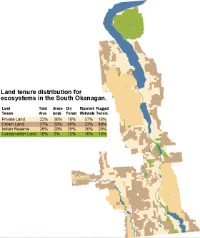
Land Tenure Distribution for Ecosystems
in the South Okanagan
The strategy must take into account the
lack of natural land left at lower elevations in the
valley, and the division of land into Crown Land, private
land, and Indian Reserves. We must use all the available
tools in a coordinated way, and the community and all
levels of government must be committed to a conservation
strategy.
Although there may be adequate opportunities for protecting
rugged terrain and forest ecosystems within conservation
and Crown lands, very little of the endangered grasslands
and riparian/wetland ecosystems are protected. Conservation
initiatives for these ecosystems will depend on land
conservation initiatives on land controlled by local
governments and First Nations.
The Role of Local Governments
Local governments and First Nations control development
of private lands and Indian Reserves and are thus key
players in a conservation strategy for the South Okanagan.
Municipalities and Regional Districts can contribute
to conservation strategies through three main avenues:
regulatory bylaws, planning and development controls
in Official Community Plans, and park designation.
The goal should be to include wildlife and habitat
conservation concerns in land use planning, thus reducing
the amount of time spent on assessing and monitoring
the negative environmental effects of individual development
proposals.
Community Planning
Under the Municipal Act, municipal governments and
regional districts regulate private land use through
Official Community Plans (OCPs). Community plans may
include, "policies of the local government relating
to the preservation, protection, restoration, and enhancement
of the natural environment, its ecosystems and biological
diversity [Section 878(1)]." The Municipal Act
also provides tax relief for owners protecting riparian
lands adjacent to streams, marshes and lakes or who
are not developing land due to wildlife concerns.
Official Community Plans can set environmental policies
that all subsequent actions such as zoning bylaws must
be consistent with. These policies can include land
designated for parks and greenway buffers, erosion control
and stormwater management.
In some rural areas, Rural Land Use Bylaws can be developed.
These combine the broad goals and policy statements
usually seen in OCPs with more specific zoning bylaws.
However, Rural Land Use bylaws are less effective at
controlling leave strips and land uses than zoning bylaws.
Local governments can also purchase covenants or obtain
long-term leases from land owners to ensure habitat
preservation or right-of-way agreements to allow for
the development of trails and greenway systems. These
tools may be effective ways to develop the buffers around
core conservation areas and the corridors linking them
that are essential to a conservation strategy.
Local governments can acquire park land for conservation
and recreation by direct purchase (e.g. using development
cost charges), land trades, donations (from individuals
or provincial government), dedication during subdivision
development plans, or by expropriation. When undeveloped
land or areas with high wildlife potential are being
considered for a subdivision, municipalities and regional
districts have an opportunity to set aside critical
habitat. For example, municipalities can ask developers
to contribute up to 5 percent of the land in a proposed
subdivision for parks purposes, or they can request
cash value for that land to purchase parks land elsewhere
in the municipality.
Proposed Guidelines Within Development Permit
Areas
People wishing to rezone, subdivide or build on land
located within a Development Permit Area that has been
established to conserve wildlife habitat can be required
to submit information on the impact of the proposed
development on the environment -- an Environmental
Impact Assessment. The information will assist
in minimizing negative impact on wildlife habitat. If
wildlife concerns outlined in the OCP are identified
and addressed at the planning stages of the development,
applicants will likely spend less time and money in
the review process than if environmental impact assessments
are done after plans have been drawn up by engineers
and architects.
The Impact Assessments
are submitted to either the municipality or regional
district and are reviewed by the Ministry of Environment,
Lands, and Parks. The assessment should determine how
the proposed development will affect wildlife habitat
and should recommend measures to reduce negative impacts
and recommend compensation for residual impacts.
The Role of the B.C. Ministry of Water, Land
and Air Protection,
Lands and Parks working with local governments
 Provincial
government staff work to protect biodiversity and species
at risk by providing information to help local governments
and private land owners make land use decisions. Provincial
government staff work to protect biodiversity and species
at risk by providing information to help local governments
and private land owners make land use decisions.
Habitat Protection Program
- Habitat staff review Impact Assessments needed
for Development Permits and make recommendations to
the approving officer, if necessary. Approval is normally
recommended, subject to the conditions and recommendations
of biologists working with the developer.
- Habitat Program Staff also review Official Community
Plans and Stewardship Bylaws and attend OCP public
meetings. They review subdivision developments and
make recommendations on Preliminary Layout Approval
(PLA) for Ministry of Highways approving officers.
They may also review First Nations development proposals
on Indian Reserves for the Department of Indian and
Northern Affairs.
Wildlife Program
Wildlife Program staff identify wildlife habitat, inventory
wildlife, and assess species vulnerability. The Program
can provide specific resources on wildlife habitat needs
for Red
and Blue-listed
species, including additional detailed maps of important
wildlife habitat. The program can also provide expertise
on management guidelines for specific wildlife issues
and priority wildlife species.
|