|
(published
1998)
Habitat Atlas for Wildlife at Risk
Preserve Ecosystem Corridors
Link Core Reserves
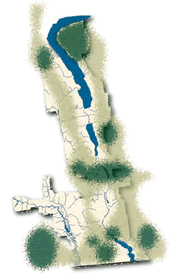 Create
buffer areas and corridors linking parks and protected
areas. Green shaded areas
represent hypothetical core protected areas (e.g. Provincial
parks, Nature Trust properties, or wildlife areas),
some of which already exist (Okanagan Mountain Provincial
Park in the northeast, Vaseux Lake holdings of Canadian
Wildlife Service and The Nature Trust, and Cathedral
Provincial Park in the southwest). Create
buffer areas and corridors linking parks and protected
areas. Green shaded areas
represent hypothetical core protected areas (e.g. Provincial
parks, Nature Trust properties, or wildlife areas),
some of which already exist (Okanagan Mountain Provincial
Park in the northeast, Vaseux Lake holdings of Canadian
Wildlife Service and The Nature Trust, and Cathedral
Provincial Park in the southwest).
The light
green shading represents desirable landscape
linkages surrounding and connecting the core areas.
These areas would have a lower level of protection,
provided by local government zoning bylaws, provincial
special management zones, and volunteer landowner stewardship
and covenants.
Landscape Linkages
For a functional biodiversity strategy, areas of similar
terrain should link the core reserves. Landscape linkages
should permit movement up and down the Okanagan Valley
on both the eastern and western sides. We must also
maintain intact elevational landscape connections from
low-elevation grasslands, lakes and wetlands up to forests,
rugged terrain and subalpine areas.
Preserve Grassland Corridors
The Okanagan is a critical biological highway to the
British Columbia central interior. Originally, the whole
of the valley could serve this purpose but the corridor
is difficult to maintain with current urban and agricultural
land use patterns divided between private, Crown and
Indian Reserve ownership.
The Okanagan Valley has been a vital landscape corridor
and linkage between the grasslands of the intermontane
areas and the Great Basin to the south, and the Thompson
Valley and Cariboo-Chilcotin grasslands to the north.
It still serves as a channel for the movement of plants
and animals. It will become even more important as a
corridor and landscape linkage with future climate change
caused by global warming.
|