Ground Water Conditions on Saltspring Island
W.S. Hodge, P. Geo.
Ground Water Hydrologist
Ground Water Section
March 1995
TABLE OF CONTENTS
Executive Summary
List of Figures
List of Tables
List of Appendices
1. Introduction
2. Location, Size and Climate
3. Bedrock and Structural Geology
4. Surficial Geology
5. Hydrogeology
6. Recharge to Local and Regional Ground Water Flow Systems
6.1 Interaction of Surface Water and Ground Water
7. Water Well Record Information
8. Ground Water Conditions within Ground Water Regions
8.1 Musgrave Region
8.2 West Fulford Harbour Region
8.3 Burgoyne Bay Region
8.4 Fulford Harbour Region
8.5 Stowell and Weston Lakes Region
8.6 King Road Region
8.7 Eleanor Point Region
8.8 Cusheon Cove Region
8.9 Beaver Point Region
8.10 Lake Maxwell Region
8.11 Cusheon Lake Region
8.12 Booth Bay Region
8.13 Ganges Harbour Region
9. Licensed Surface Water Usage and Unlicensed Ground Water Usage
10. Conclusions
11. Recommendations
12. Acknowledgements
13. References
Executive Summary
The primary objective of this assessment has been to update and compare ground water conditions on Saltspring Island between 1977 and 1992. The same approach used in 1977 (Hodge, 1977) was used in this assessment where ground water region boundaries generally represent topographic divides between natural basins. The Ground Water Section has 1535 well records for Saltspring Island up to December 1992 reflecting an increase of 134 percent in the well database since 1977. The median depth of all reported drilled wells is 47 metres (154 feet) while the median reported yield of all drilled wells is 0.15 litres/second (2 gallons/minute). The deepest drilled well is 251 metres (825 feet) and the greatest reported well yield is 7.6 litres/second (100 gallons/minute). Approximately 30 percent of the population of 8018 residents (1992 census) are serviced by ground water.
An absence of new recharge data has necessitated using the same approach used in 1977 where estimates of ground water availability in the bedrock aquifer system are based on the storativity of the aquifer to hold recharge. The hydrograph method for estimating ground water recharge was also applied on a site specific basis. Based on an average domestic usage of 2273 litres/day (500 Igpd) per well, regions presently having elevated demand/storage percentages are Scott Point region at 203 percent, Ganges Harbour region at 68 percent, Trincomali Channel region at 66 percent and Long Harbour region at 62 percent. Using a demand/storage figure of 75 percent as a benchmark to identify ground water regions where ground water demand may be exceeding ground water in storage, only Scott Point Peninsula region at 203 percent presently exceeds this benchmark. Based on the increased number of wells between 1977 and 1992, it has been predicted that Ganges Harbour region, Trincomali Channel region, Long Harbour region, and Eleanor Point region may exceed demand/storage percentages of 75 percent by the year 2010. This assessment also recognizes that surface water and ground water are two components that are interdependent and changes in one component may affect the other.
The bedrock aquifer system on Saltspring Island has been classified as IIB with a ranking value of 14 (out of a maximum 21) based on the present level of development and vulnerability to contamination. Three surficial aquifers have been identified and classified as IIB aquifers with ranking values of 8, generally reflecting the small size of the aquifers, and undocumented quantity and quality issues. There are at least 40 drilled wells constructed within these surficial aquifers.
Although present water quality data suggests the island has favourable ground water quality, most of the water quality database is older field (Hach) analysis data and may not accurately reflect current ground water quality on Saltspring Island.
Existing water quality data suggest ground water quality problems primarily exist in areas of high well density near the coast and inland in the northern part of the island where saline springs discharge salty water south and southeast of St. Mary lake and inland from Fernwood Point.
Recommendations are made for improved well record collection and database storage and retrieval, to conduct a water quality sampling program to update and better understand ground water quality on the island and the integral relationship between surface water and ground water, to better define the hydraulic characteristics of the bedrock aquifer system, to establish community water supply wells in areas inland, to implement a wellhead protection program to protect these wells from potential contaminant sources and to encourage the use of enclosed cisterns for storage of rainfall to supplement ground water supplies.
List of Figures
Figure 1: Saltspring Island — Location Map
Figure 2: Saltspring Island — Average Mean Air Temperature vs Average Monthly Precipitation — St. Mary Lake Station 1984 - 1993
Figure 3: Bedrock Geology of Saltspring Island
Figure 4: Schematic of the Hydrologic Cycle — Saltspring Island
Figure 5: Map showing Areas of Known Overburden Thickness greater than15 Metres
Figure 6: Regional Ground Water Level Elevation Contour Map
Figure 7:Saltspring Island — Ground Water Level vs Ground Elevation
Figure 8: Saltspring Island — Contour Map of Total Dissolved Solids (TDS) greater than 400 mg./L
Figure 9: Saltspring Island — Hydrograph Data vs Precipitation — St. Mary Lake Station 1984 - 1993
Figure 10: Saltspring Island — Observation Well 281 Water Level vs Precipitation
Figure 11: Estimated Recharge Values determined by the Hydrograph Method
Figure 12: Fulford Creek — Monthly Mean Discharge 1992
Figure 13: Saltspring Island — Distribution of Reported Well Depths
Figure 14: Saltspring Island — Distribution of Reported Well Yields
Figure 15: Map showing location of Wells Reporting Yield of 1.5 L/s or greater
Figure 16: Yield Frequency Probability — Saltspring Island
Figure 17: Map showing Number of Reported Wells Located within Ground Water Regions
Figure 18: Saltspring Island — Well Record Tabulation 1977 vs 1992
Figure 19: Saltspring Island — Ground Water Demand vs Ground Water in Storage 1977 vs 1992
Figure 20: Saltspring Island — Ground Water Demand vs Ground Water in Storage Percentages 1992
Figure 21: Ground Water Demand vs Ground Water in Storage 1977 and 1992 and Predictions to 2010
Figure 22: Map showing Median Well Depth and Median Well Yield within Regions
Figure 23: Saltspring Island Waterworks Districts
Figure 24: Saltspring Island — 1992 Population Served by Surface Water and Ground Water = 8018
Figure 25: Saltspring Island — Total Estimated Daily Water Usage
List of Tables
Table 1: Quantitative Estimates of Ground Water Demand vs Ground Water in Storage
Table 2: Ground Water Demand vs Ground Water in Storage to 2010
Table 3: Saltspring Island Ground Water Region Information Summary
Table 4: Saltspring Island Community Water Systems
List of Appendices
Appendix A Aquifer Classification Summary
Aquifer Classification Work Sheets
Glossary of Terms
1. Introduction
As requested by Islands Trust, an assessment of ground water conditions on Saltspring Island has been carried out. The primary objective of this assessment has been to update the report entitled "A Preliminary Geohydrological Study of Saltspring Island" (Hodge, 1977). This assessment has examined present ground water conditions within each ground water region on the island, and has attempted to better understand the integral relationship between surface water and ground water on Saltspring Island.
Between 1976 and 1992, the population of Saltspring Island increased from 3169 to 8018 permanent residents. The number of water well records in the Water Management Program database increased from 657 to 1535. Although expanded community surface water systems has reduced ground water use in some areas (e.g., Southey Point and Scott Point peninsula), ground water use in areas located outside water system boundaries appears to have increased. Increased development and ground water use is apparent within many coastal and inland areas resulting in the likelihood of increased water quality problems and local drawdown interference between wells located in areas of high well density.
This assessment has included a review of all available water well records up to December 1992, memorandum and hydrogeologic reports, observation well data, water quality data, surficial and bedrock geology maps, soils maps, aerial photographs, and field visits to the island.
2. Location, Size and Climate
Saltspring Island is located off the east coast of Vancouver Island in the Strait of Georgia (Figure 1). Ganges Harbour on Saltspring Island is located approximately 80.5 kilometres (50 miles) north of Victoria, B.C. The island is 18,555 hectares (45,849 acres) in size, 27.3 kilometres (17 miles) in length and 14.5 kilometres (9 miles) wide at it's widest point. Saltspring Island is heavily forested with primarily second growth fir, cedar, and alder. Many active farms are also located on the island. The highest elevation is Bruce Peak at 704 metres (2310 feet).
The climate of the island is characterized by cool dry summers and humid mild winters. The average annual precipitation at Vesuvius Bay for the period 1951 to 1975 is 908.8 mm or 35.8 inches and the average annual precipitation at Ganges for the period 1951 to 1977 is 1065 mm or 41.9 inches (Environment Canada, 1980). The average annual temperature at Ganges is 9.8 degrees C (49.6 degrees F) and 10.2 degrees C (50.2 degrees F) at Vesuvius Bay for the period 1951 to 1977. The AES climate stations at Vesuvius Bay and Ganges were discontinued in 1975 and 1977 respectively and AES climate stations were established near Cusheon lake in 1976 and near St. Mary lake in 1975.
The average annual precipitation near Cusheon lake for the period 1984 to 1993 is 932.2 mm (36.7 inches) and near St. Mary lake is 856 mm (33.7 inches).
July, August and September are the warmest and driest months on Saltspring Island. The average air temperature between July and September is 17 degrees C with less than 8 percent of the annual precipitation occurring over these months (Figure 2). The wettest period is between November and January when almost 50 percent of the annual precipitation occurs. Between October and April, 80 to 85 percent of the annual precipitation occurs on Saltspring Island (Van Vliet et al, 1987).
3. Bedrock and Structural Geology
The bedrock geology of Saltspring Island is both varied and complex. Saltspring Island is underlain by sedimentary rocks of upper Cretaceous age belonging to the Nanaimo Group (Figure 3). The Nanaimo Group is a conformable sequence of marine and non-marine sediments for which five major depositional periods have been recognized (Muller and Jeletzky, 1970). Sandstone, shale, siltstone, conglomerate, and very rarely coal, occupy the northern half of the island.
Older more resistant metamorphosed igneous and sedimentary rocks occupy the southern more mountainous half of the island (Figure 3). Metamorphosed igneous rocks occur north of Fulford valley, south of Cusheon lake, and along the westerly slopes of Mount Maxwell. South of Fulford valley the bedrock type is Palaeozoic metamorphosed sedimentary rock belonging to the greywacke-argillite formation of the Sicker Group (Van Vliet et al, 1987). The highlands are comprised of more resistant and less fractured sandstones, shales, and conglomerates (Van Vliet et al, 1987).
Three main northwest-southeast trending folds account for the segmented structure of Saltspring Island (Halstead, 1967). These folds are characterized by three highland areas separated by low-lying parallel channels which slope gently towards the ocean (Figure 4). Each of the three highland areas on Saltspring Island is characterized by moderately sloping north faces with steep cliffs of 60 to 200 metres (197 to 656 feet) on the southern faces (Halstead, 1967).
The valley regions, particularly the Ganges Harbour-Booth Bay areas are underlain by less resistant, more fractured shale beds. The shales are mainly dark grey fine sandy shales with thin interbeds of brownish grey fine-grained sandstones (Halstead, 1967).
Baynes Peak, which is underlain by shale and sandstone of the Nanaimo Group has an elevation of 595 metres (1955 feet). Mount Tuam has an elevation of 630 metres (2067 feet) while Bruce Peak, the highest elevation on Saltspring Island occurs at 704 metres (2310 feet). Mount Tuam and Bruce Peak are both underlain by rocks of the Sicker Group (Van Vliet et al, 1987).
4. Surficial Geology
Most of the surficial deposits present today were once transported and deposited by glaciers, rivers, lakes, and the sea since the last glaciation. During and after the last glaciation, marine waters entered the depressional areas and covered a large part of the present lowlands of the Gulf Islands, including Saltspring Island (Halstead, 1967). Consequently, thick unconsolidated deposits are present in the lower valley regions. Soils maps show soil cover less than 100 cm (40 inches), however, is common throughout Saltspring Island. Well records show the median depth of overburden on Saltspring Island is 2.4 metres (8 feet). Unconsolidated deposits on Saltspring Island consist of till, glaciofluvial gravel and sand, and glaciomarine clay deposits as well as recent colluvial and bog deposits (Wei, 1981). The greatest recorded thickness of overburden is 69 metres (226 feet) based on lithology of a well located in a topographically low area northeast of Burgoyne Bay. Surficial deposits over 30.5 metres (greater than100 feet) deep are apparent at lower elevations along the Beddis road/Ganges Harbour area and around Fulford Harbour and Walker Hook. There are 13 wells on the island reporting unconsolidated deposits of greater than 30.5 metres (greater than100 feet) thick. Locally, thick unconsolidated deposits up to 30.5 metres (100 feet) have been observed inland within the central area of Saltspring Island. In general, however, unconsolidated deposits in most upland areas have been eroded down to the underlying bedrock, except for small pockets or on protected side slopes. Areas of known overburden thickness of greater than 15 metres (greater than 50 feet) based on well record lithology have been shown in Figure 5. Successful wells have been constructed in some of these deposits where local aquifers occur between finer grained deposits. There are approximately 40 drilled wells with reported yields between 0.06 litres/second (0.75 gallons/minute) and 1.1 litres/second (15 gallons /minute) located within these local surficial aquifers.
Thick unconsolidated deposits may also provide storage for recharge to bedrock aquifers.
5. Hydrogeology
The availability of ground water depends upon the storage facilities available at ground surface for the intake of the balance of precipitation after losses due to overland runoff, evaporation, transpiration and surface storage (lakes, ponds, and streams etc.).
Ground water occurrence and movement in bedrock on Saltspring Island is governed by local geology, availability of openings (pores and fractures) in the bedrock, recharge, and movement of water from areas of recharge towards points or areas of discharge. Rock types can vary significantly in their ability to store and transmit water. The openings can be intergrain pores in the sandstone or shales or more likely movement of water can occur through bedrock and be mainly confined to bedding planes, faults and joints.
Regional ground water level elevations in bedrock have been estimated from land surface elevations and historical water level measurements in bedrock wells and have been manually contoured (Figure 6).
Topography varies from level to gently rolling in low-lying valley areas to very steep in the more mountainous areas. Ground water levels reflect the water table surface in bedrock on Saltspring Island assuming steady-state flow conditions and essentially horizontal flow. The relationship between topography and ground water level elevations from bedrock wells (Figures 6 and 7) suggest the highest ground water level elevations occur inland at higher elevation while lower ground water level elevations occur in the valleys and coastal areas. Negative ground water elevations or unusually low ground water elevations may reflect water levels under pumping conditions in wells located near coastal areas, slow recovery of the water level in low permeability bedrock immediately after the well was drilled or possible inexact well location. Ground water flow directions in bedrock (Figure 6) were inferred from the ground water elevations assuming the bedrock permeability is isotropic or uniform throughout.
While complex geologic and hydrologic conditions and well record information suggests there could be several distinct bedrock aquifers on the island, limited geologic and hydrologic data do not allow specific delineation of bedrock aquifer boundaries at this time. Until further data become available, the bedrock on Saltspring Island has been classified as one aquifer system. Three unconsolidated confined aquifers as shown in Figure 5 and exceeding 1 km2 (0.62 mi2) in size have also been identified and classified.
The map-based aquifer classification system developed by Kreye et al, (1994) was used to classify the aquifers on Saltspring Island. The system classifies aquifers on the basis of their level of development (use) and vulnerability to contamination and provides ranking values for aquifers using hydrogeologic and water use criteria. The ranking component indicates the relative importance of an aquifer and is determined by summing the point values for aquifer productivity, size, vulnerability, demand, type of use, quality concerns and quantity concerns. According to Kreye et al, (1994) possible ranking scores range from a low of 5 to a high of 21. The higher the ranking score the greater the aquifer's priority.
The bedrock aquifer system on Saltspring Island has been classified as IIB with a ranking value of 14. The IIB classification indicates that the aquifer is moderately developed and moderately vulnerable to contamination from surface sources. Bedrock aquifers generally have relatively lower ranking values (between 6 and 9), reflecting lower productivity, lower demand and fewer documented quality /quantity issues (Kreye et al, 1994). A ranking of 14 may reflect how unique bedrock aquifers of the Gulf Islands are where generally high ground water demand and water quality and quantity issues are evident.
The three identified surficial aquifers have been classified as IIB indicating the aquifers are moderately developed and moderately vulnerable to contamination from surface sources. Each surficial aquifer has a ranking value of 8 which reflects the size of the aquifer, domestic use, and lack of any documented quantity and quality concerns. The aquifer classification summary and aquifer classification work sheets are shown in Appendix A.
Most of the wells are completed into the bedrock aquifer system. Approximately 70 percent of the wells on the island have been completed within the northern half of the island in sandstones and/or shale deposits of the Nanaimo Group. Successful wells have also been completed in the southern portion of the island in granodiorite or granite of the Upper Jurassic and Lower Cretaceous Coast Intrusions (eg. Cusheon Cove region and Eleanor Point region).
Sea water intrusion is evident within the northern part of the island at Scott Point, Southey Point, Booth Bay and Erskine Point and within the southern part of the island inland of Fulford Harbour. Total dissolved solids have been contoured and shown in Figure 8. Water quality data have been adapted from Hodge (1977) and supplemented by recent field water quality data (Gallo, 1992 and Yakelashek, 1993). Unfortunately very limited water quality data have been obtained on the island since 1973. Poor water quality in some locations throughout the northern portion of the island can be attributed in part to the marine origin of the sedimentary rocks. The Fernwood springs (Figure 8) are located inland about 1.6 km (1 mile) west of Fernwood Point and discharge salty water through near vertical dipping shaley sandstone (Halstead, 1967). Highly saline ground water is also evident south and southeast of St. Mary lake.
6. Recharge to Local and Regional Ground Water Flow Systems
Most recharge to the bedrock flow regime on Saltspring Island is likely from direct infiltration of precipitation at ground surface and is controlled by a number of factors including the intensity and duration of precipitation, thickness and porosity of the overburden, and the shape and hydraulic conductivity of the bedrock surface.
Most of the water that percolates to the saturated zone moves through shallow local flow systems until discharging into streams as base flow or discharging as small springs. Some of the water moves downward to the deeper regional ground water flow system (Figure 4).
Estimates of ground water availability in the bedrock aquifer system are based on the storativity of the aquifer to hold recharge (Table 1). Aquifer storativity and bedrock fracture permeability are the more limiting factors for ground water recharge and not total precipitation (Foweraker, 1974). Although it is recognized that bedrock characteristics can change readily and locally, and the bedrock geology of Saltspring Island is complex, absence of detailed hydrogeological data (i.e. geophysical data, test drilling, pumping test data), has necessitated a simplified approach. An average storage coefficient of 10-4 has therefore been used in the determination of ground water in storage. Typical storage coefficients for a bedrock aquifer range from 10-3 to 10-5 (Driscoll, 1986).
Foweraker (1974) considered the annual available recharge to the bedrock aquifer(s) on Mayne Island from precipitation as 25.4 mm (1-inch) or about 3 percent, based on an average annual precipitation of 838 mm (33 inches). As a similar climate and bedrock environment exists for Saltspring Island, the same recharge rate of 25.4 mm (1-inch) was utilized on a regional scale in the 1977 report and in this report. This was compared to estimated recharge rates determined on a site specific basis for observation well 281 using the hydrograph method. The hydrograph method and results obtained are discussed below.
Water levels in a low capacity (0.04 litres/second or 0.5 gallons/minute) bedrock observation well have been monitored near Scott Point peninsula since 1983 (Figure 6). Figure 9 shows the relationship between water levels in observation well 281 and precipitation between the period 1984 and 1993. Although some effect from ocean tides is evident, the hydrograph does show good response to precipitation. The lowest water levels occur in the late summer and early fall corresponding to the periods of little or no precipitation. It is also important to note that the cycle of minimum precipitation coincides with the period of heaviest ground water use. Figure 10 shows clearer the relationship between a specific rainfall event and water level response in the observation well.
This relationship has allowed estimation of aquifer recharge rates for specific precipitation/water level response events and seasonal responses using the hydrograph method for estimating recharge (Kohut, 1987). The hydrograph method involves determining the annual net rise in water level in an observation well accounting for probable discharge during the recharge period and converting this to an equivalent quantity of water necessary to produce the observed water level rise (Figure 11). Short-term recharge rates determined for water level response to a specific rainfall event ranged between 0.00049 and 0.0034 metres/month while recharge rates ranged between 0.00009 and 0.00015 metres/month for extended seasonal monitoring periods (Figure 11). For reasons given earlier, an unconfined storativity of 10-4 was used in estimating recharge. In terms of precipitation, 25.4 mm (1-inch) of precipitation available for recharge to the bedrock aquifer represents a recharge rate of 0.0021 metres/month. On this basis, the range of recharge rates between 0.00009 and 0.0034 metres/month determined by the hydrograph method represents precipitation infiltration of between 1.0 mm (0.045 inches) and 43.2 mm (1.7 inches). These figures suggest that Foweraker's (1974) estimate of 25.4 mm (1-inch) of precipitation available for annual recharge to the bedrock aquifer(s) is reasonable when applied on a regional scale.
It is clear, however, that a change in one order of magnitude of storativity can also change available recharge by one order of magnitude. For example, if an unconfined storativity of 10-3 was used in estimating recharge, infiltration values given above would change to between 0.45 inches and 17 inches of precipitation available for annual recharge. The hydraulic properties of the bedrock should therefore be better defined in future studies in order to predict and evaluate the consequences of future island development with respect to ground water storage and demand. Due to lack of data, recharge rates to surficial aquifers cannot be estimated at this time.
6.1 Interaction of Surface Water and Ground Water
An important hydraulic relationship may also exist between many of the numerous creeks, streams, lakes, wetlands and the ground water system on Saltspring Island. Surface water and ground water are two components of the total water budget that are interdependent and changes in one component may effect the other.
In the past, ground water and surface water have been studied independently, however, it must be acknowledged that these components are interdependent. Coordinated development and management of the combined resource is vital.
Two hydrometric stations are located on Saltspring Island (Barnett et al., 1993). The locations of these hydrometric stations are located in Figure 6. Flows are monitored at Cusheon creek year round, and seasonally from April to September at Duck creek and Fulford creek. All streams on the island experience mean monthly low flow during the June to October period (Barnett et al., 1993).
Fulford creek flow records for 1992 were plotted (Figure 12) to show the surface water/ground water relationship because it is the only monitored creek that maintains flow year round. Unfortunately Fulford creek is only monitored seasonally during the low flow period and a complete hydrograph is not available for analyses. Although Cusheon creek is monitored year round, zero base flow is evident during the June to October period.
As shown in Figure 12, during the period June to September it is likely that ground water contributes significantly to Fulford creek discharge. Fulford creek discharges between 0.015 m3/s (198 Igpm) and 0.023 m3/s (303 Igpm) at this time of year and it is roughly estimated that the total flow between June and September exceeds 136380 m3 (30 x 106 Imperial gallons). Much of this flow is likely sustained by ground water flow. The Fulford Creek station appears to be in a regional ground water discharge area. Ground water discharge of this volume at this time of year may impact on local wells.
It is apparent that further knowledge on watersheds and drainage basins is required for evidence of how one component effects the other. Design and construction of piezometers to obtain rate and direction of ground water flow, lag time and infiltration characteristics and water quality sampling of surface water / ground water are also necessary to better understand surface water / ground water interaction. The possibility of seepage meters installed in lake bottoms to monitor seepage through lake beds should also be investigated.
When the Water Allocation Plan is revised in 1999 (Barnett et al., 1993) the Plan should consider the interaction between surface water and ground water.
7. Water Well Record Information
As of December 1992, the Ground Water Section had 1535 water well records on file for Saltspring Island. This figure includes 1280 records of water wells plotted on 1: 5000 scale maps and 255 records of unplotted water wells. Of this number, approximately 90 percent of wells are drilled while the remaining 10 percent are dug wells. The median well depth of all drilled wells is 47 metres (154 feet) and the deepest well recorded is 251.5 metres (825 feet) located on the west side of Long Harbour. Drilled wells constructed prior to the 1970's are generally similar depth; less than 38 metres (125 feet), and many of these wells are constructed on or near waterfront properties. Well depth distribution vs number of wells has been shown in Figure 13.
There may, however, be a greater number of wells on the island, as submission of water well records is not mandatory. It is also not known if all wells are used. Some wells may be unused or abandoned because of inadequate quality or quantity and some residents may now be on a community surface water system. Well frequency versus reported well yield is shown in Figure 14. The median reported well yield for all wells is 0.15 litres/second (2 gallons/minute). Forty-eight wells have reported yields of 1.5 litres/second (20 gallons/minute) or higher and the highest reported well yield is 7.6 litres/second (100 gallons/minute) for two wells. Wells with reported capacities of greater than 1.5 litres/second (20 gallons/minute) are shown in Figure 15. Based on 962 drilled wells with reported yields, the percent probability of obtaining a particular yield with one well has been calculated and shown in Figure 16. For example, the probability of drilling a well with a yield of 1 L/s (13 gallons/minute) would be 5 percent, based on Figure 16. Wells completed into surficial and bedrock aquifers have not been differentiated. The yield frequency probability plot may be partially biased as it does not include those drill holes reported as "dry".
Reported well yields are estimated by drilling contractors from bail tests or during development at the time of well construction and may not be as accurate as yields estimated from pumping tests.
8. Ground Water Conditions within Ground Water Regions
In order to update and compare ground water conditions between 1977 and 1992, the same approach used in 1977 where Saltspring Island was divided into 18 ground water regions has been used in this report. As in the 1977 report, boundaries between these regions represent the topographic divides between natural basins and in most instances the regions correspond with surface drainage watersheds. Figure 17 shows the number of well records on file within each ground water region and Figure 18 shows well record tabulation in 1977 compared to 1992.
As in the 1977 report, total potable ground water in storage was determined by multiplying the region area by an average potable aquifer thickness of 60 metres (200 feet) and storage coefficient of 10-4.
GWstorage = A x b x S
where: GWstorage = volume of ground water in storage (m3)
A = area of ground water region (m2)
b = average potable aquifer thickness (60 metres)
S = storage coefficient (10-4).
Estimates of ground water demand were determined by multiplying the number of wells located within the region by the average domestic daily usage of 2273 litres/day or 500 Igpd and the normal 100 day period of little or no recharge from precipitation during which ground water in storage is used to supply demand.
GWdemand = N x Q x t
where: GW demand = annual volume of ground water demand (m3) which may come from storage
N = number of wells in ground water region
Q = daily domestic requirement ( 0.05 m3/day)
t = period of little or no recharge from precipitation (100 days)
Although not all wells may be used and residents previously dependent on well water may now utilize surface water, it is not possible under this study to establish whether wells on file are in use or are abandoned on a region-by-region basis, as well owners are not required to report this information. As noted previously, there may be many wells on Saltspring Island that may be active and unreported so this simplified approach seems reasonable as a general indicator of the relative amount of ground water use in each region.
The demand/storage percentage is calculated as shown below:
Demand/Storage Percentage = GW demand x 100 % GW storage
The demand/storage ratio is a useful, general indicator of overall ground water use and whether demand is approaching or exceeding supply. As in the 1977 report, demand/storage percentages approaching 75 percent identify regions where ground water usage may be exceeding ground water in storage (Figure 19 and 20).
Based on 1977 and 1992 demand/storage percentages, extrapolations have been made up to the year 2010. As shown in Figure 21 and Table 2, Ganges Harbour region, Long Harbour region, Trincomali Channel region, and Eleanor Point region may exceed demand/storage percentages of 75 percent by the year 2010 if present growth trends continue. The assumption that all wells in a given region are in use may not be as valid as the number of wells increase.
Because of data limitations, these figures must be viewed with considerable reservation. Demand/storage percentages should be used only as a framework for regional planning and not for making detailed management decisions.
Following is a brief discussion on the known hydrogeological and hydrochemical changes between 1977 and 1992 within each ground water region. For ease of reference, important statistical information on each ground water region has been shown in Table 3. Discussions also focus on factors which can affect the rate at which infiltration of precipitation to recharge bedrock aquifers can occur. Some of the factors discussed are type and extent of vegetal cover, description and thickness of overburden, description of bedrock surface, and topographic features of the region. Where applicable, surface water sources have been noted and discussed.
8.1 Musgrave Region
The Musgrave region, largest on Saltspring Island encompasses 3227 hectares (7975 acres) or 17.4 percent of Saltspring Island and is characterized by rugged, steep slopes and mountainous terrain. The highest mountain within this region is Bruce Peak at 704 metres (2310 feet) above sea level. The region is heavily forested with primarily second growth fir and cedar. Much of the Musgrave region may be restrictive for development because of the steep and mountainous terrain.
The number of drilled wells at 22 has increased moderately (1977 - 4 drilled wells). Drilled well depths range from 30.5 metres (100 feet) to 146 metres (480 feet) while reported well yields range from 0.07 litres/second (1 gallon/minute) to 3.8 litres/second (50 gallons/minute). The median well depth is 35 metres (115 feet) while the median well yield is 0.15 litres/second or 2 gallons/minute (Figure 22).
Most wells are located near the coast near Musgrave Landing and to the southeast along Maxham road and Isabella Point road. Near Maxwell Landing, well records show clay overburden ranges in thickness from 1.5 metres to 5.5 metres (5 feet to 18 feet) and overlies shale and sandstone bedrock. At least 25 percent of the Musgrave region is covered by exposed or moss or soil (less than 10 cm thick) over metamorphosed sedimentary bedrock (Van Vliet et al, 1987). Although many factors influence the rate at which surface water infiltration can occur and recharge aquifers, the type and thickness of vegetal cover can be one important factor. Areas of exposed bedrock obviously can not benefit from this factor.
Water levels measured at the time of drilling in wells near Musgrave Landing range from 1.4 metres to 16.8 metres (4.5 feet to 55 feet) below ground surface. Mount Tuam and the surrounding mountainous terrain likely provide ground water recharge to the wells within this region, with ground water flow direction likely occurring from inland in a southwesterly direction towards the coast. The steep terrain likely promotes considerable surface water runoff. Although most wells are located near the ocean and completed below sea level, steep terrain may provide sufficient hydraulic head in wells to prevent sea water intruding inland. As no recognized surface water systems exist within this region, except possibly some intermittent creeks or streams associated with small drainages, ground water is likely the sole source of water supply for residents located within the Musgrave region.
Ground water quality data are not available. Actual ground water demand versus ground water in storage ratio (Table 1) based on 2273 litres/day (500 Igpd) average domestic demand per household remains insignificant at 3 percent (1977 - 0.5 percent). Because of rugged and steeply sloping terrain, development within this region is generally restricted to a few low-lying coastal areas.
8.2 West Fulford Harbour Region
West Fulford Harbour region is located east of Musgrave region and encompasses 788 hectares (1948 acres). It is bounded by rugged, steeply sloping topography inland which then slopes moderately (about 12 to 17 percent slope) towards Fulford Harbour. The region is heavily forested with primarily second growth fir and cedar.
Considerable well construction has occurred since 1977, where records of 67 drilled wells, 8 dug wells, and 9 springs are now on file (1977 - 14 drilled wells).
Except where intermittent creeks or streams associated with small drainages are evident, ground water is likely the sole source of water supply for residents located within the West Fulford Harbour region. The Cedars of Tuam waterworks district is a ground water system that also provides domestic water to residents (15 dwellings) in this region (Figure 23).
Most wells are located at a ground elevation of less than 122 metres (400 feet) above sea level in the vicinity of Roland road or along Isabella Point road. Many of the wells located within this region are completed below sea level. Thick overburden is evident at lower elevations along Roland road where overburden thickness to 31.4 metres (103 feet) has been reported and also near the coast off Isabella Point road where thickness to 34.4 metres (113 feet) has been reported. Although some successful drilled wells have been completed in the sand and gravel aquifer along (Fulford Harbour sand and gravel aquifer) Roland road, most wells in this region are completed in bedrock described as either shale or granite.
Ground water flow from higher mountainous areas inland likely occurs in an easterly direction towards Fulford Harbour. Shallow water levels are evident in some wells located inland along Isabella Point road, where ground water may be discharging locally. Considerable spring activity is also evident along Isabella Point road. The deepest drilled well located within this region is 153 metres (502 feet) while the median well depth is 52 metres or 170 feet (Figure 22). The highest reported well yield is 3.8 litres/second or 50 gallons/minute, while the median well yield is 0.15 litres/second or 2 gallons/minute (Figure 22). There are three wells located within this region with reported yields of 1.5 litres/second (20 gallons /minute) or greater (Figure 15).
Water quality data are limited to only one well tested for laboratory analysis which indicates the ground water was alkaline (pH 8.1), moderately hard (hardness 115 mg/L), and moderately mineralized (specific conductance 316 micromhos/cm). In August 1993, four wells were tested for field (Hach) analysis. Results obtained suggest ground water is alkaline (pH 7.5 - 8.5), hard (hardness 189 - 233 mg/L), and moderately mineralized (specific conductance 340 - 420 micromhos/cm). Three of these wells were located inland and one was located near the coast off Roland road. Deeper drilled wells located along Fulford-Ganges road and along Isabella Point road near the coast have not been tested for water quality analysis.
Ground water demand versus ground water in storage ratio has increased from 11.8 percent (1977) to 40 percent (1992). Although a 40 percent ratio suggests that, while there is no immediate cause for concern regionally, water quality and pumping interference problems may occur locally where deeper drilled wells completed below sea level are clustered on small lots located adjacent to Fulford Harbour.
8.3 Burgoyne Bay Region
Burgoyne Bay region is situated along the central west coast of Saltspring Island and encompasses 1086 hectares (2684 acres). Mount Maxwell's (elevation 579 metres or 1900 feet ) near vertical south face with slopes reaching 60 percent, bounds the northeast boundary while Bruce Peak (elevation 704 metres or 2310 feet) bounds the south slopes.
The region is heavily forested and remains relatively undeveloped. Except for a few shallow dug wells, local springs and creeks are the only reported source of domestic and irrigation water supply. No drilled well records are on Ground Water Section files. Water quality data are not available.
Ground water demand versus ground water in storage ratio remains insignificant at 2.0 percent (1977 - 0.85 percent).
8.4 Fulford Harbour Region
Fulford Harbour region is situated within south central Saltspring Island and encompasses 2496 hectares (6168 acres). Since 1977, considerable drilled well construction has occurred both inland and along coastal areas with 105 drilled wells reported (1977 - 5 drilled wells).
Numerous older dug wells exist, inland where local shallow ground water flow systems are intercepted and which supply residents with domestic and irrigation water supply. Other older dug wells exist at lower elevation adjacent to Fulford creek where Fulford creek may be a local source of recharge and near the mouth of Fulford Harbour. Dug wells located in this area are completed in silty clay loam to silty clay marine deposits.
Extreme to very steep topography slopes toward Fulford Creek which exists along the gently sloping to level low-lying valley floor.
Water levels measured at the time of well construction in wells range from 0.61 metres (2 feet) to 81 metres (265 feet) below ground level. The deepest water levels are evident inland at higher elevation in areas of high well density. Soil cover on the steep slopes is generally shallow at less than 100 cm (40 inches) and can be described as colluvial and glacial drift over metamorphosed sedimentary bedrock. Marine deposits greater than 100 cm (40 inches) exist along Fulford creek and the valley floor. Well records show overburden as deep as 55.2 metres (181 feet) in a well located between Fulford-Ganges road and Cusheon lake.
The deepest drilled well located within this region is 213 metres (700 feet) located at lower elevation between Fulford creek and Fulford-Ganges road. Many drilled wells located at lower elevation adjacent to Fulford-Ganges road and near the mouth of Fulford Harbour are completed below sea level and may be susceptible to sea water intrusion during the late summer or early fall when ground water demand is greatest and ground water recharge is minimal.
The median depth of all drilled wells within this region is 61 metres or 200 feet (Figure 22). The highest reported well yield is 3.0 litres/second or 40 gallons /minute (Figure 15) while the median well yield is 0.23 litres/second or 3 gallons /minute (Figure 22). There are 10 wells located within this region reporting yields of 1.5 litres/second (20 gallons/minute) or greater (Figure 15).
Water quality data are limited and available only for shallow dug wells.
Deeper drilled wells within this region have not been tested for water quality analysis.
Ground water demand versus ground water in storage ratio has increased from 5.8 percent (1977) to 22 percent (1992).
Although a 22 percent ratio suggests that, while there is no immediate cause for concern regionally, water quality and pumping interference problems may occur locally where deeper drilled wells located adjacent to Fulford creek and near the mouth of Fulford Harbour may be susceptible to pumping interference and sea water intrusion problems. Because of proximity of wells to Fulford Creek, surface water/ground water conflicts are possible.
8.5 Stowell and Weston Lakes Region
The Stowell and Weston lakes region is bounded by Fulford Harbour to the south and encompasses 1220 hectares (3014 acres). Topography generally slopes moderately to strongly (10-30 percent) from higher elevation towards Weston lake (elevation 71.6 metres or 235 feet) and Stowell lake (elevation 64 metres or 210 feet). Since 1977, well construction has increased from 45 to 108 drilled and dug wells (including 6 springs). The increase since 1977 has been all drilled wells. Most drilled wells are located inland and are completed in metamorphosed sedimentary bedrock. Soil cover in this region is generally shallow (less than 100 cm or 40 inches ) and can be described as colluvial and glacial drift over metamorphosed sedimentary bedrock. Exposed bedrock or bedrock covered by moss or soil less than 10 cm (4 inches) thick is common in this region. Minor deposits of marine and/or fluvial deposits greater than 100 cm or 40 inches) thick occur in pockets or along creek channels (i.e. Weston creek). Well records show the deepest overburden thickness is 33.5 metres (110 feet) in a well located off Isabella Point road.
Water levels measured at the time of well construction in wells are generally shallow ranging from 0.61 metres (2 feet) to 12.2 metres (40 feet) below ground surface.
The deepest drilled well located within this region is 140 metres (460 feet) while the median depth of drilled wells is 45.7 metres or 150 feet (Figure 22). The median well yield is 0.23 litres/second or 3 gallons/minute (Figure 22). There are 2 wells located within this region reporting yields of 1.5 litres/second or 20 gallons /minute (Figure 15).
Weston lake, Weston creek and Stowell lake are licensed water sources. Weston lake is also a community waterworks district and supplies domestic water to Fulford Harbour residents. Fulford waterworks district has 96 connections (1991 Census).
Ten ground water sources (5 drilled wells and 5 springs) were sampled for field analysis in 1973 and specific conductivity ranged from 140 to 380 micromhos/cm and pH ranged from 6.2 to 7.7 at the time of sampling.
Ground water demand versus ground water in storage ratio has increased from 11.4 percent (1977) to 33 percent (1992). Although a 33 percent ratio suggests that, while there is no immediate cause for concern regionally, water quality and pumping interference problems may occur locally where drilled wells are clustered inland.
8.6 King Road Region
King Road region is situated east of Stowell & Weston lake region and encompasses 363 hectares (897 acres). Since 1977, well construction has increased from 22 to 52 drilled and dug wells (including 5 springs). The increase since 1977 has been drilled wells and well construction has occurred both inland and along coastal areas. Drilled wells are completed in metamorphosed sedimentary bedrock.
Soil cover in this region is generally shallow (less than 100 cm or 40 inches) and can be described as colluvial and glacial drift over metamorphosed sedimentary bedrock. Exposed bedrock or bedrock covered by moss or soil less than 10 cm (4 inches) thick is common in this region. Minor deposits of marine and/or fluvial deposits greater than 100 cm (40 inches) thick occur in pockets or thin layers. Topography is variable ranging from moderate to gentle slopes (15-6 percent) near coastal areas to extreme slopes inland (46-70 percent). Water levels measured at the time of well construction in wells are generally shallow ranging from 1.5 metres (5 feet) to 13.7 metres (45 feet) below ground surface.
Well records show the deepest overburden thickness as 6.7 metres (22 feet). The deepest drilled well located within this region is 145 metres (475 feet) while the median depth of drilled wells within this region is 50.3 metres or 165 feet and the median well yield is 0.15 litres/second or 2 gallons/minute (Figure 22). There are two wells located within this region reporting yields of 2.3 litres/second or 30 gallons/minute (Figure 15) .
Five ground water sources (3 drilled wells, 1 dug well and 1 spring) were sampled for field analysis in 1973 and specific conductivity ranged from 190 to 360 micromhos/cm and pH ranged from 6.2 to 7.2 at the time of sampling.
Ground water demand versus ground water in storage ratio has increased from 17 percent (1977) to 42 percent (1992). Although a 42 percent ratio suggests that, while there is no immediate cause for concern regionally, water quality and pumping interference problems may occur locally where drilled wells are clustered inland. Drilled wells clustered along the coast may be susceptible to pumping interference and sea water intrusion.
8.7 Eleanor Point Region
Eleanor Point region is situated east of King Road region and encompasses 329 hectares (812 acres). Topography is variable ranging from gentle to strong slopes (6-30 percent) sloping in a south and southeasterly direction towards the ocean. Since 1977, well construction has increased from 14 to 47 drilled and dug wells (including 1 spring ). A significant part of this region includes Ruckle Provincial Park and most of the ground water development exists in the central and coastal areas.
Soil cover in this region is generally shallow at 100 cm (40 inches) and can be described as colluvial and glacial drift over metamorphosed sedimentary bedrock interspersed by pockets of marine or fluvial deposits over marine deposits greater than 100 cm deep (40 inches). Colluvial and glacial drift materials less than 100 cm (40 inches) deep over sandstone bedrock is evident within the eastern part of this region.
Well records show overburden as deep as 15.2 metres (50 feet) inland near Stevens road. The deepest drilled well located within this region is 129 metres (425 feet) while the median depth of all drilled wells is 61 metres or 200 feet (Figure 22). The highest reported well yield is 7.6 litres/second or 100 gallons/minute (Figure 15) for a well located inland off Eagle Way road while the median well yield is 0.23 litres /second or 3 gallons/minute (Figure 22).
Six ground water sources (5 drilled wells and 1 spring) were sampled for field analysis in 1973 and specific conductivity ranged from 150 to 425 micromhos/cm and pH ranged from 6.2 to 7.5 at the time of sampling.
Ground water demand versus ground water in storage ratio has increased from 13.2 percent (1977) to 53 percent (1992). Although a 53 percent ratio suggests that, while there is no immediate cause for concern regionally, water quality and pumping interference problems may occur locally where drilled wells are clustered inland and near the coast.
8.8 Cusheon Cove Region
Cusheon Cove region is situated north of King Road region and encompasses 344 hectares (849 acres). Topography is variable, ranging from strong to steep slopes along the coast to gentle to strong slopes (6-30 percent) inland, sloping in a northerly direction towards the ocean.
Since 1977, well construction has increased from 9 to 35 drilled and dug wells (including 2 springs). The increase since 1977 has been drilled wells completed inland in metamorphosed sedimentary bedrock.
Soil cover in this region is generally shallow (less than 100 cm or 40 inches) and can be described as colluvial and glacial drift over metamorphosed sedimentary bedrock interspersed by pockets of marine or fluvial deposits over marine deposits greater than 100 cm deep or 40 inches.
Well records show overburden as deep as 5.2 metres (17 feet). The deepest drilled well located within this region is 134 metres (440 feet) while the median depth of drilled wells is 61 metres or 200 feet (Figure 22). The highest reported well yield is 3.4 litres/second or 45 gallons/minute (Figure 15) while the median well yield is 0.19 litres/second or 2.5 gallons/minute (Figure 22).
Ground water quality data are not presently available.
Ground water demand versus ground water in storage ratio has increased from 8.1 percent (1977) to 38 percent (1992). Although a 38 percent ratio suggests that, while there is no immediate cause for concern regionally, water quality and pumping interference problems could occur locally where drilled wells may be clustered.
8.9 Beaver Point Region
Beaver Point region is bounded by Cusheon Cove region on the west and Swanson Channel on the east and encompasses 311 hectares (768 acres). Topography slopes moderately to gently in an easterly direction towards Swanson Channel. No well construction is reported to have taken place in this region since 1977.
Part of Ruckle Provincial Park which includes the historic Ruckle farm is included within this region.
Well records show overburden as deep as 7.6 metres (25 feet). The deepest drilled well located within this region is 100.6 metres (330 feet) while the median depth of drilled wells is 69 metres or 225 feet (Figure 22). The highest reported well yield is 0.23 litres/second or 3 gallons/minute (Figure 15) while the median well yield is 0.15 litres/second or 2 gallons/minute (Figure 22).
In August 1993, the Ruckle Provincial Park well was tested for field analysis (specific conductivity 350 micromhos/cm and pH 7.7)
Ground water demand versus ground water in storage ratio remains low at 6 percent (1977 - 5 percent).
8.10 Lake Maxwell Region
Lake Maxwell region is situated within the central part of Saltspring Island south of Booth Bay region and encompasses 1088 hectares (2688 acres). The region is characterized by rugged mountainous terrain and very limited development. Lake Maxwell which provides community water supply for the area is located within this region at an elevation of about 325 metres (1065 feet) above sea level.
Well records show overburden as deep as 19.8 metres (65 feet) at an elevation of about 213 metres (700 feet). Most drilled wells in this region are completed in fractured shale. Some spring activity is evident along Toynbee road at an elevation of about 244 metres (800 feet). The deepest drilled well located within this region is 201 metres (660 feet). This well is also located off Toynbee road and was flowing at the time of construction. Maxwell lake may be a source of local recharge to wells and springs in this area. The median depth of drilled wells is 46 metres or 150 feet (Figure 22). The highest reported well yield is 2.3 litres/second or 30 gallons/minute (Figure 15) while the median well yield is 0.15 litres/second or 2 gallons/minute (Figure 22).
Three ground water sources (2 dug wells and 1 spring) were sampled for field analysis in 1973 and specific conductivity ranged from 125 to 200 micromhos/cm and pH ranged from 6.5 to 7.0 at the time of sampling.
Actual ground water demand versus ground water in storage ratio remains low at 8 percent (1977 - 2.3 percent).
8.11 Cusheon Lake Region
Cusheon Lake Region is located within the central part of the island encompassing 1130 hectares (2793 acres). Topography slopes moderately to strongly along the north and south ridges of the region and moderately gentle to gentle at lower elevation. Blackburn lake drains southeast to Cusheon lake with Cusheon creek draining from Cusheon lake southeast to the ocean. Surface water and ground water community water supply systems and individual wells service local residents within the Cusheon Lake region. Blackburn and Cusheon lakes supply surface water to many local residents.
Since 1977, well construction has increased from 14 to 62 drilled and dug wells. The increase since 1977 has been drilled wells and well construction has occurred throughout the region. High local well density does not appear to exist in this region. The majority of drilled wells have been constructed in fractured shales and sandstones.
Soil conditions are variable, ranging from exposed conglomerate bedrock at higher elevations to marine deposits greater than 100 cm (40 inches) deep around Blackburn and Cusheon lakes. Deep overburden is evident at lower elevation north of Blackburn lake where well records have shown unconsolidated deposits as deep as 30 metres (100 feet). Some successful wells have been constructed in unconsolidated deposits in this area. A principal source of recharge to bedrock and surficial wells located at lower elevation may be Blackburn and Cusheon lakes and associated creeks.
The deepest drilled located within this region is 172 metres (565 feet) while the median depth of drilled wells is 45.7 metres or 150 feet (Figure 22).
The highest reported well yield is 7.6 litres/second or 100 gallons/minute (Figure 15) for a well located near the northwest boundary of the region at an elevation of about 245 metres (800 feet) asl. The median well yield within the region is 0.15 litres/second or 2 gallons/minute (Figure 22).
Water quality data are older (1973) and limited to a few analyses for wells located north of Cusheon lake. Total dissolved solids ranges between 174 and 360 mg/L.
Ground water demand versus ground water in storage ratio remains low at 20 percent (1977 - 3.8 percent).
8.12 Booth Bay Region
Booth Bay region encompasses 888 hectares (2195 acres) and is defined by Mount Erskine to the south and to the north, a linear ridge extending southeast from Vesuvius Bay. Topography slopes moderately to strongly from Mount Erskine to the south and moderately from the north ridge towards Booth Inlet. Booth Inlet is a topographically low channel which helps to define the segmented structure of Saltspring Island.
Soil conditions can be described generally as glacial drift less than 100 cm (40 inches) thick over shale and sandstone bedrock along the side slopes to gravelly morainal deposits less than 100 cm (40 inches) thick over unweathered till at lower elevations around Booth Inlet. The North Saltspring waterworks district supplies domestic water from St. Mary lake to many residents within Booth Bay region. Individual wells and Duck creek also service many residents.
Since 1977, well construction has increased from 45 to 92 drilled and dug wells. Most recent well construction has occurred inland at lower elevation around Booth Inlet and to the south along the side slopes.
The deepest drilled well located within this region is 113 metres (370 feet) while the median well depth is 38 metres or 125 feet (Figure 22). The highest reported well yield is 5.7 litres/second or 75 gallons/minute (Figure 15) and the median well yield is 0.11 litres/second or 1.5 gallons/minute (Figure 22).
Water quality data are older (1973), and consist of about 15 laboratory and field analysis results. Total dissolved solids range between 220 and 450 micromhos/cm for shallow dug wells located at lower elevation around Booth Inlet. A well drilled to a depth of 30 metres or 97 feet located near Booth Inlet encountered salt and was subsequently sealed. Another well located at higher elevation inland and south of Booth Bay, drilled to a depth of 46 metres (150 feet), also reported elevated TDS and chloride levels of 3190 mg/L and 1433 mg/L respectively. As indicated in the 1977 report, this could be due to possible extension of saline ground waters that occur south of St. Mary Lake.
Ground water demand versus ground water in storage ratio has increased from 15.7 percent (1977) to 41 percent (1992). Although a 41 percent ratio suggests that, while there is no immediate cause for concern regionally, pumping interference could occur locally where drilled wells are clustered. Construction of drilled wells around Booth Inlet and inland south of St. Mary lake may be risky due to sea water intrusion and the presence of highly saline ground water.
8.13 Ganges Harbour Region
Ganges Harbour region encompasses 640 hectares (1581 acres). Topography is variable and generally slopes moderately to very strongly (10-45 percent) along the southern and northern entrances to Ganges Harbour with gentle to moderate slopes more evident around Ganges and inland. Surface water and ground water community water supply systems and individual wells service residents within the Ganges Harbour region. North Saltspring waterworks district obtains water from St. Mary lake and Maxwell lake and supplies many of the residents and commercial establishments in and around the town of Ganges while Beddis waterworks district obtains water from Cusheon lake and supplies water to many residents within the southern boundaries of Ganges Harbour region. The smaller ground water systems of Harbour view and Mount Belcher supply domestic and irrigation water to 20 and 43 connections respectively within Ganges Harbour region. Figure 23 shows the boundaries of both surface water and ground water community water supply systems.
Since 1977, well construction has increased from 203 to 340 drilled and dug wells (including 8 springs). The increase since 1977 has been drilled wells and the most recent well construction has occurred inland. The majority of drilled wells have been constructed in fractured shales and sandstones.
Deep overburden is evident between Lower Beddis road and Ganges Harbour where well records have shown unconsolidated deposits as deep as 41 metres (135 feet). Some successful wells have been constructed in the surficial sand and gravel aquifer in this area (Ganges Harbour sand and gravel aquifer).
The deepest drilled well located within this region, and the deepest well on Saltspring Island, is 251.5 metres (825 feet) while the median depth of drilled wells is 38 metres or 125 feet (Figure 22). The highest reported well yield is 4.5 litres/second or 60 gallons/minute (Figure 15) while the median well yield is 0.15 litres/second or 2 gallons/minute (Figure 22).
Thirty-two ground water sources (17 drilled wells, 11 dug wells and 4 springs) were sampled for field analysis in 1973. Many sample sources were dug and drilled wells located on waterfront lots. Specific conductivity as high as 8000 micromhos/cm has been detected in a well located near Welbury Point off Old Scott road. High well density is also very evident in this area. Highly mineralized ground water is evident in a well located near the coast off Beddis road where sodium chloride levels as elevated as 2600 mg/L have been detected. Highly mineralized ground water is also evident inland off Upper Ganges road south of Bullock lake where specific conductivity as high as 8000 micromhos/cm have been detected from spring activity in the area. These springs may be an extension of old saline water or seawater that locally discharge salty water through near vertical dipping shaley sandstone. No recent water quality data are available.
Ground water demand versus ground water in storage ratio has increased from 34.1 percent (1977) to 68 percent (1992). Although a 68 percent ratio percent ratio does not indicate the necessity for restricting future well development, this figure coupled with the present water quality concerns both inland and near the coast does suggest that caution be exercised in future well location and construction. Many wells are located on waterfront lots which could be subject to sea water intrusion, particularly during the late summer and early fall when demand is greatest and water levels are low. Deeper wells completed inland on lots off Upper Ganges road south of Bullocks lake may also be subject to poor water quality where highly saline springs are located.
8.14 Scott Point Peninsula Region
Scott Point Peninsula region is a narrow, forested, heavily subdivided, peninsula of very limited catchment area surrounded by ocean and encompassing 31 hectares (77 acres). Scott Point peninsula was formed when glacial erosion and other types of erosion removed less resistant beds on both sides (Livingston, 1979).
Scott Point peninsula is underlain by sedimentary rocks (sandstone and conglomerate) of Upper Cretaceous age belonging to the Nanaimo Group. The sandstones and conglomerates strike along Scott Point and dip northeasterly.
Sea water intrusion is evident in the Scott Point peninsula. Although the bedrock of Scott Point peninsula is fractured, the fractures are quite narrow and the amount of water stored in the rock is small (Livingston, 1979). Water in the fractured rock comes almost entirely from precipitation which falls on the peninsula (Livingston, 1979). The fresh water in the fractured rock forms a lens which floats on top of sea water which is heavier. Intensive pumping depletes this fresh water lens resulting in wells yielding brackish water particularly during the late summer or early fall when ground water recharge is minimal and demand is highest.
Although construction of additional wells was not recommended (Hodge, 1977; Livingston, 1979), well construction has increased from 8 drilled wells to 17 drilled wells since 1977.
Most of the 60 residences on Scott Point peninsula do not use their wells for domestic purpose, however, because of experiencing water quality and well interference problems and are now connected to the Scott Point waterworks district. Many residents, however, continue to use their wells for garden use only. Scott Point waterworks district has 5 production wells located on the peninsula. The most recent production well was constructed in December 1991 and was rated at 0.75 litres/second (10 gallons/minute).
Well records show overburden as deep as 6.4 metres ( 21 feet) while the median depth of overburden is 0.61 metres (2 feet). The deepest drilled well is 74.7 metres (245 feet) while the median depth of drilled wells is 51.8 metres or 170 feet (Figure 22)). The highest reported well yield is 1.5 litres/second or 20 gallons/ minute (Figure 15) while the median well yield is 0.11 litres/second or 1.5 gallons /minute (Figure 22).
Four wells were analyzed for field (Hach) analysis in April, 1992 with specific conductivity ranging from 550 to 900 micromhos/cm and chloride ranging from 68 to 300 mg/L.
In 1978, a 152 mm (6-inch) diameter test production well was constructed inland from Scott Point peninsula in an effort to locate a high capacity, potable water supply for local residents. The well was completed to a depth of 107 metres (350 feet) with a total estimated capacity of only 0.07 litres/second (1.0 gallon/minute) from two water bearing zones located at 84 metres (275 feet) and 107 metres (350 feet). The well was established as an observation well in 1983 and an automatic water level recorder was installed to monitor water levels on a continuous basis. Water quality is monitored every two years and based on a pumped water sample collected in August 1993, the ground water can be classified as alkaline (pH 8.0), hard (hardness 212 mg/L), and moderately to highly mineralized (specific conductance 834 micromhos /cm). The chloride dissolved level was 167 mg/L.
Because of the increase in well construction, ground water demand versus ground water in storage ratio (Figure 20) has increased from 79.7 percent (1977) to 203 percent (1992). This figure may be inflated because, as stated above, most residences are now connected to Scott Point waterworks district and many residents now use their wells for garden use only. This figure does identify the area as a problem area with respect to overwithdrawal of ground water.
8.15 St. Mary Lake Region
St. Mary lake region is located within north central Saltspring Island and encompasses 1150 hectares (2842 acres). Topography generally slopes moderately to extreme along the west and eastern shores of St. Mary lake while the north and southern shores slope gently to moderately. St. Mary lake, the largest lake on Saltspring Island having a surface area of 181 hectares (447 acres), and at an elevation of 44.8 metres (147 feet) above sea level, is centrally located within this region. North Saltspring waterworks district supplies domestic and irrigation water to residences north and west of St. Mary lake while Fernwood waterworks district supplies residences northeast of St. Mary lake. The boundaries of these waterworks districts are shown in Figure 22. Both waterworks districts obtain water from St. Mary lake. The North Saltspring waterworks district has 1512 connections while the Fernwood waterworks district has 69 connections (1991 Census).
Marine or fluvial deposits over compact, unweathered till is evident within the south and north shores of St. Mary lake. Well records show overburden near the northern shore of St. Mary lake as deep as 11.3 metres (37 feet) while records show overburden as deep as 6.4 metres (77 feet) further north of St. Mary lake. Most active wells are located along the eastern shore and inland of St. Mary lake. Since 1977, well construction has increased from 41 to 116 drilled and dug wells (including 4 springs ). The increase since 1977 has been drilled wells and the most recent well construction has occurred southeast of St. Mary lake. Drilled wells have been constructed in fractured shales and sandstones and the majority of wells appear to be low capacity (less than 0.07 litres/second or 1 gallon/minute).
The deepest drilled well located within this region is 250 metres (820 feet) while the median depth of drilled wells is 53.3 metres or 175 feet (Figure 22). The highest reported well yield is 1.1 litres/second or 15 gallons/minute (Figure 15) while the median well yield is 0.11 litres/second or 1.5 gallons/minute (Figure 22).
Water quality data (1973) are available for fourteen ground water sources (10 drilled wells, 3 dug wells and 1 spring). Specific conductivity ranged from 180 to 1070 micromhos/cm and pH ranged from 6.0 to 9.2 at the time of sampling. One well located east of St. Mary lake off North End road, however, reported "salty water" when drilled in 1970. This could be due to possible extension of saline ground waters that occur south of St. Mary lake. Only one well has been sampled for complete chemical analysis. This well is observation well 276 which was abandoned in May 1991. The well was returned to it's owner for domestic use.
Ground water demand versus ground water in storage ratio has increased from 11.3 percent (1977) to 38 percent (1992). Although a 38 percent ratio suggests that, while there is no immediate cause for concern regionally, pumping interference could occur locally where drilled wells are clustered. Construction of wells south of St. Mary lake within this region may be risky due to the presence of highly saline ground water.
8.16 Long Harbour Region
Long Harbour region encompasses 640 hectares (1581 acres) and is bounded by Trincomali Channel region to the north and Ganges Harbour region to the south. Topography generally slopes moderately to very strongly towards Long Harbour. Cedar Lane waterworks district supplies domestic and irrigation water inland to 30 connections (1991 Census) from production wells. The majority of domestic wells are located along the Long Harbour coast. Many wells are located near the coast at low ground elevation and completed below sea level. Much of the region inland exists at an elevation at less than 31 metres (100 feet) above sea level. Well records show overburden is generally shallow with the deepest overburden recorded as 7.6 metres (25 feet). Bedrock at surface is common within this region.
Since 1977, well construction has increased from 24 to 108 drilled and dug wells (including 2 springs). The increase since 1977 has been drilled wells and the most recent well construction has occurred on lots both inland and along the coast. Drilled wells have been constructed in fractured shales and sandstones and the majority of wells appear to be low capacity (0.07 litres/second or 1 gallon/minute or less). The deepest well on Saltspring Island, at 251.5 metres (825 feet), is located off Harbourside Place at low elevation near the coast. The median depth of drilled wells is 53.3 metres or 175 feet (Figure 22). The highest reported well yield is 1.9 litres/second or 25 gallons/minute (Figure 15) while the median well yield is 0.15 litres/second or 2 gallons/minute (Figure 22). There are 5 wells reporting yields of 1.5 litres/second (20 gallons/minute) or greater located within this region (Figure 15).
Seventeen ground water sources (12 drilled wells and 5 dug wells) were sampled for field analysis in 1973. Most sample sources are dug and drilled wells located on waterfront lots adjacent to Long Harbour and specific conductivity ranged from 230 to 600 micromhos/cm and pH ranged from 6.0 to 8.7 at the time of sampling. One well located inland near the boundary of Long Harbour region and Ganges Harbour region and owned by the Cedarlane waterworks district had a chloride level of 77,760 mg/L (August 1973) indicating highly saline ground waters were encountered at this location, a probable extension of the saline springs. Other wells in this area report "brackish" water. No recent water quality data, however, are available.
Ground water demand versus ground water in storage ratio has increased from 12.1 percent (1977) to 62 percent (1992). Although a 62 percent ratio does not indicate the necessity for restricting future well development, this figure coupled with the present water quality concerns both inland and near the coast does suggest that caution be exercised in future well location and construction. Many wells are located on waterfront lots which could be subject to sea water intrusion, particularly during the late summer and early fall when demand is greatest and water levels are low.
8.17 Trincomali Channel Region
Trincomali Channel region encompasses 1295 hectares (3200 acres) and extends from Long Harbour to near Southey Point along the northeast coast of Saltspring Island. Topography slopes moderately to very gently north of Walker Hook while south of Walker Hook, topography slopes strongly to very steep. The Highlands waterworks district and North Saltspring waterworks district supply domestic and irrigation water from St. Mary lake to many residents within this region. The majority of wells in this region are located near Walker Hook and north of Fernwood Point in the vicinity of North Beach road and North End road. North of Walker Hook, land surface is low-lying and numerous wells located near the coast are completed below sea level. Overburden is generally very deep in this area with many well records reporting overburden exceeding 15.2 metres (50 feet). Well records show overburden as deep as 43 metres (140 feet) for a well located inland from Walker Hook. Numerous successful wells have been completed in the overburden or surficial aquifer here which exists under confined conditions (Walker Hook sand and gravel aquifer).
Since 1977, well construction has increased from 105 to 228 drilled and dug wells (including 10 springs). The increase since 1977 has been drilled wells and the most recent well construction has occurred inland along North End road and inland from Walker Hook.
The deepest drilled well located within this region is 198 metres (650 feet) while the median depth of drilled wells is 45.7 metres or 150 feet (Figure 22). Drilled wells have been constructed in fractured shales and sandstones and many wells have low capacity (0.07 litres/second or 1 gallon/minute or less). The highest reported well yield is 5.7 litres/second (75 gallons/minute) for a well located off Walker Hook road opposite Walker Hook, while the median well yield is 0.15 litres /second or 2 gallons/minute (Figure 22). There are 4 wells located within this region that report well yields of 1.5 litres/second (20 gallons/minute) or higher (Figure 15).
Laboratory and field water quality data are available for 32 ground water sources and most data were obtained in 1973. Data indicates highly saline ground water is evident inland. The Fernwood springs are located about 1.6 km (1 mile) inland from Fernwood Point and discharge highly concentrated brines (Figure 8). Saltspring Island is named after the saline springs and according to Hill (1983) there are fourteen or fifteen saline springs on the island. Salt water contamination is also evident in some bedrock wells located near the coast along North Beach road.
Actual ground water demand versus ground water in storage ratio has increased from 23.9 percent (1977) to 66 percent (1992). Although a 66 percent ratio does not indicate the necessity for restricting future well development, this figure coupled with the present water quality concerns both inland and near the coast does suggest that caution be exercised in future well location and construction. Drilled wells constructed in this low-lying area are vulnerable to well interference where drilled wells are clustered and to sea water entrusion where wells are completed below sea level.
8.18 Houston Region
Houston region encompasses 575 hectares (1421 acres) and is situated on the northwest side of Saltspring Island extending south to north from Parminter Point to Southey Point. Most wells are located north of Stone Cutters Bay. Most residences have now abandoned their wells because of poor well capacity and water quality and are now connected to North Saltspring waterworks district. As a result, very few wells have been constructed since 1977.
It is interesting to note that some bedrock wells constructed on waterfront properties within this region during the early 1970s are quite deep to 118 metres (388 feet). It appears that this may have been a time when water well contractors began to investigate the deeper bedrock aquifers on Saltspring Island.
Well records show overburden as deep as 8.2 metres (27 feet). The deepest drilled well is 118 metres (388 feet) while the median depth of drilled wells is 39.6 metres or 130 feet (Figure 22). The highest reported well yield is 0.91 litres/second or 12 gallons/minute (Figure 15) while the median well yield is 0.07 litres/second or 1 gallon/minute (Figure 22).
Ground water demand versus ground water in storage ratio has increased from 19.4 percent (1977) to 27 percent (1992). This region is serviced by North Saltspring waterworks district and many residents may now use their wells for garden use only.
9. Licensed Surface Water Usage and Unlicensed Ground Water Usage
Saltspring Island is fortunate to have an abundance of surface water sources for domestic, irrigation, and industrial water supply. Licensed surface water sources include about 94 spring licences, 53 stream licences, 13 lake licences and licences on a number of ponds and swamps (Barnett et al., 1993). Lakes supply most of the water demand on Saltspring Island. Maxwell lake is reported to drain into Blackburn lake which drains into Cusheon lake which in turn drains into Fulford Harbour. St. Mary lake is the largest and most important source of surface water supply on Saltspring Island. Major lakes utilized as a source of licensed water supply are St. Mary lake, Cusheon lake, Maxwell lake, Blackburn lake, Bullocks lake, Ford lake, Weston lake, and Stowell lake.
There are five surface water community water systems on Saltspring Island licensed to withdraw surface water from St. Mary lake, Cusheon lake, Weston lake, and Maxwell lake (Table 4). The location and boundaries of these water systems have been shown in Figure 23. A total of 1991 households are connected to these systems (per. comm. Mike Larmer, 1994 ). Based on an average of 2.33 persons per household (per. comm. Mike Larmer, 1994), 4639 (1991 x 2.33) residents or 58 percent of the population of 8018 were serviced by community surface water systems in 1991 (Table 4 and Figure 24). It has been estimated that 957 residents or 12 percent of the population utilize surface water for domestic, irrigation or industrial purposes (411 licences x 2.33).
There are 5 ground water systems on Saltspring Island (Table 4) having a total of 168 connections or households. It is estimated that these systems provide domestic ground water to 391 residents (168 x 2.33) or 5 percent of the total population. By simple deduction, therefore, it is estimated that 2031 persons or 25 percent of the population is serviced by domestic wells. Further, it should be noted that if the figure of 2.33 residents per household is used and each household utilizes one well, then it is possible that a total of only 872 wells (2031÷ 2.33) may be actively used on Saltspring Island as of December 1992. Without a program of mandatory well record submission and ground water licensing, however, it is not possible to know the number and location of all active wells on Saltspring Island. It is therefore viewed as acceptable to base the findings in this report on the 1535 water well records on file, including determination of demand/storage calculations with the knowledge that demand/storage calculations quoted may be somewhat inflated.
Total daily water usage has been estimated at 171 L/s (3,249,000 Igpd). Total daily water usage was determined as follows: Based on 0.03 L/s (500 Igpd) per household for the 1991 households connected to surface water systems, it is estimated that 52.3 L/s (995,500 Igpd) would be utilized (Figure 25). It is estimated that a maximum of 73.7 L/s (1,401,806 Igpd) is utilized from the 411 active licences (these licences are for domestic, irrigation and industrial purposes and represent a major percentage of the total water usage at 43 percent). Based on 0.03 L/s (500 Igpd) for each of the 168 connections, the ground water community systems would utilize 4.4 L/s (84,000 Igpd), while the 1535 wells would utilize 40.3 L/s (767,500 Igpd) based on 0.03 L/s (500 Igpd) per well. If the figure of only 872 wells is considered then 22.9 L/s (436,000 Igpd) would be utilized with respect to domestic ground water use and the total daily water usage would be 154 L/s (2,917,000 Igpd).
10. Conclusions
- The Ground Water Section has 1535 records of wells for Saltspring Island up to 1992. This figure reflects a 134 percent increase in the well database since 1977 (1977 - 657 wells) and represents 1280 plotted and 255 unplotted wells. All wells reported since 1977 are drilled wells and most are 152 mm (6-inch) diameter and have been constructed by the air-rotary method of drilling. Approximately 90 percent of 1535 wells are drilled while the remaining 10 percent are dug wells. It is, however, not possible under this study to know the status of wells since they were constructed.
Some wells may be abandoned because of water quality problems or insufficient quantity and other residents may now be utilizing surface water. As submission of well records by drilling contractors is not compulsory, many unreported wells may also exist on Saltspring Island.
- The median depth of all reported drilled wells on Saltspring Island is 46.9 metres (154 feet) and the deepest drilled well on record is 251 metres (825 feet) located on the west side of Long Harbour. Drilled wells constructed prior to the 1970's are generally of similar depth; less than 38 metres (125 feet) and the majority of wells were constructed on or near waterfront properties. While the majority of wells are completed in bedrock, successful wells have been completed in local surficial aquifers that are interspersed between finer grained deposits. There are at least 40 drilled wells with reported yields between 0.06 litres/second (0.75 gallons/minute) and 1.1 litres/second (15 gallons/minute) located within these surficial aquifers.
- The median reported yield of all drilled wells on Saltspring Island is 0.15 litres /second (2 gallons/minute). Forty-eight wells have reported yields of 1.5 litres /second (20 gallons/minute) or greater and the highest reported well yield is 7.6 litres/second (100 gallons/minute) for two wells. Reported well yields are, however, estimated by drilling contractors from bail tests or during development at the time of well construction and may not be as accurate as pumping tests for determining long-term yields.
- As limited geologic and hydrologic data do not allow delineation of bedrock aquifer boundaries, Saltspring Island has been classified as one bedrock aquifer system at this time. The aquifer has been classified as a IIB aquifer with a ranking value of 14. The IIB classification indicates the aquifer is moderately developed and moderately vulnerable to contamination from surface sources. The ranking value of 14 indicates generally high ground water demand is evident with some documentation of water quality and quantity problems. Three surficial aquifers have been identified and located on Saltspring Island. These aquifers have been named: Walker Hook Aquifer, Ganges Harbour Aquifer and Fulford Harbour Aquifer. These aquifers have been classified as llB aquifers each with a ranking value of 8. The ranking value indicates the surficial aquifers are smaller, used for domestic requirements only and quantity and quality concerns have not been documented.
- Most recharge to the bedrock aquifer system on Saltspring Island is likely from direct infiltration of precipitation at ground surface. Absence of geophysical, test drilling and pumping test data has necessitated a simplified approach in assessing recharge estimates to the bedrock aquifer system. The same approach used in the 1977 report has been applied here where 25.4 mm (1-inch) of precipitation is available for ground water recharge with recognition that the more limiting factors for ground water recharge are aquifer storativity and bedrock fracture permeability and not total precipitation. Water level data from observation well 281 located near Scott Point Peninsula has allowed application of the hydrograph method in estimating recharge rates on a site specific basis. Results obtained suggest that 25.4 mm (1-inch) of precipitation available for ground water recharge is reasonable for application on a regional scale.
- Using a figure of 75 percent as a benchmark to identify ground water regions where ground water demand may be exceeding ground water in storage, only Scott Point Peninsula region at 203 percent presently exceeds this benchmark. As most residents of Scott Point peninsula are now connected to the Scott Point waterworks district this figure may, however, be misleading, although it does serve to identify this region as a problem area. Other regions that presently have elevated demand /storage percentages are Ganges Harbour region (68 percent), Trincomali Channel region (66 percent), and Long Harbour region (62 percent). Although these figures do not suggest restricting future well development, the figures do indicate that with water quality concerns both inland and near the coast, caution should be exercised in future well location and construction. It is recognized that ground water demand vs ground water in storage percentages have been determined on a regional scale and assume homogeneous hydrogeologic conditions. Demand/storage percentages should therefore be used only as a framework for regional planning and not for making detailed management decisions.
- Based on 1977 and 1992 data, ground water demand/storage predictions have been given to the year 2010. Besides Scott Point region; Ganges Harbour region, Trincomali Channel region, Long Harbour region, and Eleanor Point region may exceed demand/storage percentages of 75 percent by the year 2010 if present growth trends continue.
- Saltspring Island is fortunate to have many surface water sources for domestic, irrigation and commercial water supply and does not rely entirely on ground water for water supply. Although 30 percent of the island population is supplied by ground water, lakes supply most of the water supply on Saltspring Island. It is estimated that 4639 residents or 58 percent of the population of Saltspring Island was serviced by surface water utilities in 1991. It has been further estimated that another 957 residents or 12 percent of the population utilize surface water for domestic, irrigation or industrial purposes. Surface water quality has not been addressed in this report.
- An important hydraulic relationship may also exist between many of the numerous creeks, streams, lakes, wetlands and the ground water system on Saltspring Island. Surface water and ground water are two components of the total water budget that are interdependent and changes in one component may effect the other. During the period June to September, ground water likely contributes significantly to Fulford creek discharge. Coordinated development and management of the combined resource is therefore vital.
- Although present water quality data suggests that Saltspring Island has favourable ground water quality, most of the water quality database are older field (Hach) analyses data, dating back to 1973 and generally represent water quality from shallow dug wells and springs. Very limited water quality data are available from drilled wells. Existing water quality data have suggested ground water quality problems have been detected earlier in areas of high well density near the coast. Ground water quality problems are also known to exist in some locations in the northern portion of the island which may be attributed in part to the marine origin of the sedimentary rocks and inland where saline springs discharge salty water south and southeast of St. Mary lake and inland from Fernwood Point. Because of extensive development of Saltspring Island since 1977, and lack of ground water quality data from the deeper bedrock flow regime, the existing water quality database may not, accurately reflect current ground water quality on Saltspring Island.
- Although it is recognized that improperly located or improperly designed sewage disposal systems can contribute to poor and non-potable ground water, because of lack of available data, the potential for sewage effluent contamination of wells has not been addressed in this report.
11. Recommendations
- For future studies, it is important that the hydraulic properties of the bedrock aquifer system be better defined in order to predict and evaluate the consequences of future island development with respect to ground water. A realistic approach to obtain this information may be for Islands Trust to request Professional Engineer or Geoscientist reports for development of ground water supplies now required for new lots being created by subdivision (Subdivision Bylaw 207). This information may allow determination of aquifer characteristics such as location of water bearing fractures, specific capacity, hydraulic conductivity, transmissivity, and water quality and will allow a more meaningful assessment of bedrock aquifer recharge and storage capacity as well as water quality. All hydrogeologic information obtained should be entered on the Ministry's Computerized Ground Water Database System (CGDS).
- A water quality sampling program should be carried out in an effort to better understand ground water quality on Saltspring Island and to further delineate water quality problem areas. Drilled and dug wells should be selected from inland and coastal areas and sampled for field and laboratory analysis. As a pilot study, and to better understand the integral relationship between surface water and ground water, wells, flowing wells and springs located downslope of St. Mary lake, Cusheon lake and Weston lake should be sampled in an attempt to determine if these surface water sources provide recharge to the ground water system. Analysis should include total dissolved solids and salinity which would be helpful in determining the position and characteristics of the fresh water/salt water interface in wells located near the coast as well as the major ions, nutrients, and bacteria. The sampling program should be carried out during the late summer or early fall when ground water demand is greatest and ground water recharge is minimal. All available WQCP data could be collected, identified and matched with information on the Ministry's CGDS. This project could be carried out by a Coop student with training , supervision and field sampling equipment being provided by Ground Water Section staff. It is anticipated that the total cost for this sampling program would be about $20,000.00 which would include approximately $10,000.00 for a Coop salary and analytical costs of about $10,000.00 for 50 laboratory analysis.
- When the Water Allocation Plan is revised in 1999 it should consider how ground water use may affect surface water quantity. Further knowledge on the interaction between surface water and ground water is necessary to obtain a greater understanding of how these two components impact on each other. Coordinated development and management of the combined resource is vital.
- Additional observation wells should be established to monitor long-term ground water level and quality trends on Saltspring Island. Bedrock observation wells are desirable in Ground Water regions where demand/storage percentages are presently elevated (Ganges Harbour region, Long Harbour region and Trincomali Channel region) and within the upland area west of Cusheon Lake. Observation wells should also be established within the three identified surficial aquifers (Walker Hook, Ganges Harbour, and Fulford Harbour aquifers). It is likely that some abandoned domestic wells may be identified as being suitably constructed, strategically located and having potential as long-term observation wells.
- Dug and drilled abandoned wells should be identified and owners made aware on the importance of having these wells properly decommissioned with demonstrated methods of safe closure.
- Well records should be collected from drilling contractors on a once per year basis and data routinely entered on the CGDS to further understand ground water conditions on Saltspring Island.
- Consideration should be given to establishment of community water supply wells in areas inland to provide service to areas where well construction is undesirable because of water quality problems or high well density. If community water supply wells are established, a wellhead protection program should be implemented to protect these wells from potential contaminant sources.
- Residents and visitors should be made aware of basic water conservation measures to protect and preserve the ground water resource on Saltspring Island. One example of conservation is the use of enclosed cisterns for storage of rainwater to supplement water supply particularly in those ground water regions presently having demand/storage percentages that approach or exceed 75 percent. Residents and visitors should also be informed of appropriate land use practices in order to reduce the risk of potential ground water contamination from surface sources.
12. Acknowledgements
The author would like to give special thanks to Mike Wei for his patience, helpful suggestions and constructive criticism in the writing of this report.
13. References
Barnett, L., Blecic, B. and Van Bruggen, W., 1993. Saltspring Island, Water Allocation Plan. Province of British Columbia, Ministry of Environment, Lands and Parks, Vancouver Island Region.
B. C. Environment, 1993. Ground Water Resources of British Columbia. Water Management Division, Hydrology Branch, Ground Water Section, Ministry of Environment, Lands and Parks Publication.
Best, R.V., 1973. Cretaceous Geology, Saltspring Island. Thesis. University of British Columbia, Department of Geological Sciences. File 92 B/14 #10.
Driscoll, F.G., 1986. Ground Water and Wells. Second Edition. Johnson Division, St. Paul Minnisota 55112.
Environment Canada, 1980. Canadian Climate Normals 1951 - 1980. Temperature and Precipitation, British Columbia.
Foweraker, J. C., 1974. Ground Water Investigations on Mayne Island, Report No. 1. Evaluation, Development and Management of the Ground Water Resource on Mayne Island. Department of Lands, Forests, and Water Resources. File 02329013.
Freeze, R.A., and J.A. Cherry, 1979. Ground Water. Prentice-Hall, Inc. Englewood Cliffs, NJ.
Gallo, M., 1992. Memorandum on Field Water Quality Results. Ministry of Environment, Lands and Parks, Water Management Division, Ground Water Section.
Halstead, E.C., 1967. Hydrogeology of the Coastal Lowland Nanaimo to Victoria, Vancouver Island, including the Gulf Islands, B.C. Inland Water Branch, Dept. of Energy, Mines and Resources.
Hill, B., Mouat, S., Cunningham, M. and Horsdal, L., 1983. Times Past . Saltspring Island Houses and History before the turn of the century. Community Arts Council.
Kohut, A.P., 1987. Ground Water Supply Capability Abbotsford Upland.. Province of British Columbia, Ministry of Environment and Parks, Water Management Branch.
Hodge, W.S., 1977. A Preliminary Geohydrological Study of Saltspring Island. Ground Water Section, Hydrology Division, Water Investigations Branch, B.C. Ministry of the Environment.
Kreye, R., Ronneseth, K., and Wei, M., 1994. An Aquifer Classification System for Ground Water Management in British Columbia (submitted). Sixth National Drinking Water Conference, BCWWA. Victoria, B.C. 13 p.
Livingston, E., 1979. Ground Water Supply - Scott Point Waterworks District. Pacific Hydrology Consultants Ltd.
Muller, J.E., and Jeletzky, J.A.,1970. Geology of the Upper Cretaceous Nanaimo Group, Vancouver Island and Gulf Islands, British Columbia. Geological Survey of Canada, Paper 69-25.
Van Vliet, L.J.P., Green, A.J. and Kenney, E.A., 1987. Soils of the Gulf Islands of British Columbia, Volume 1, Soils of Saltspring Island. Report No. 43 of the British Columbia Soil Survey. Research Branch Agriculture Canada 1987.
Viessman, W., Lewis, G., and Knapp, J., 1989. Introduction to Hydrology. Third Edition. Harper and Row.
Wei, M., 1981. Hydrogeology of Saltspring Island. Field Notes prepared for Ground Water Section, Water Management Branch, Ministry of Environment, Victoria, B.C. File 092B/14 #14.
Whitten, D.G.A., Brooks, J.R.V., 1979. The Penguin Dictionary of Geology. Penguin Books Ltd. Harmonsworth, Middlesex, England.
Yakelashek, S., 1993. A Preliminary Summary of Ground Water Conditions on Saltspring Island. Work Term Report in partial fulfilment of the requirements of the Geography Co-op Programme. Department of Geography, University of Victoria.
| 
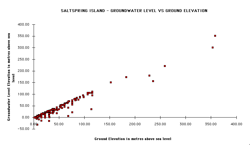
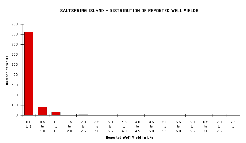
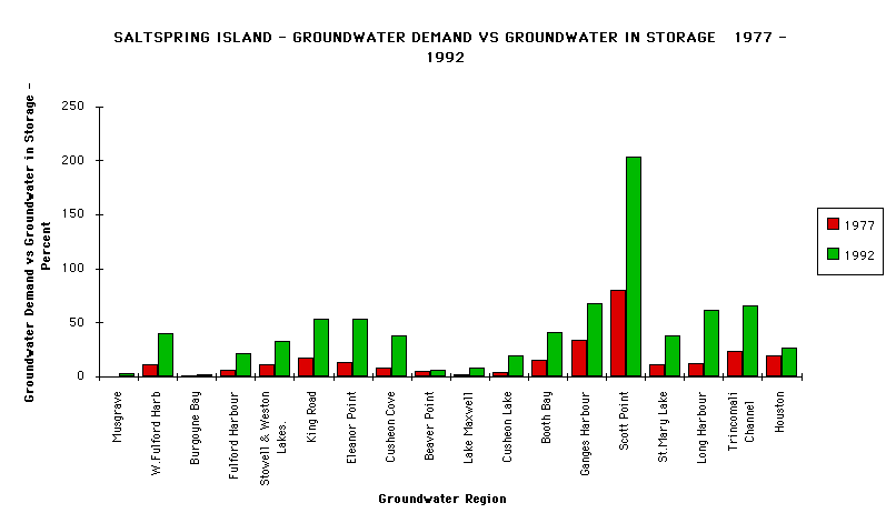
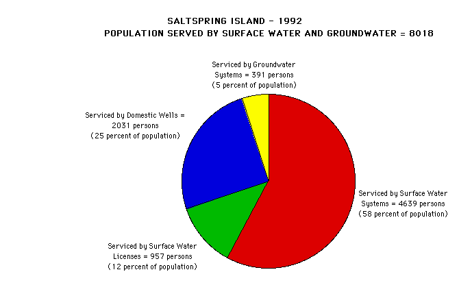
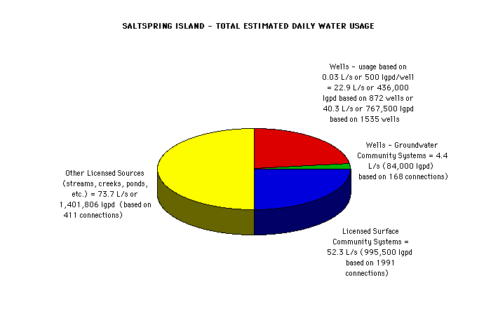
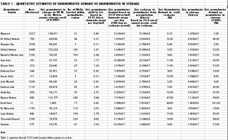
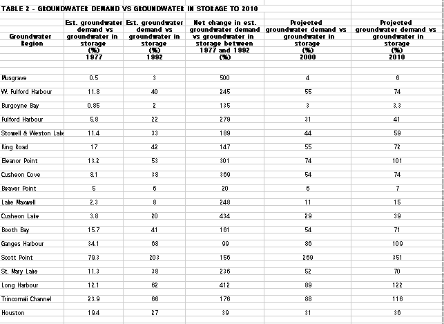
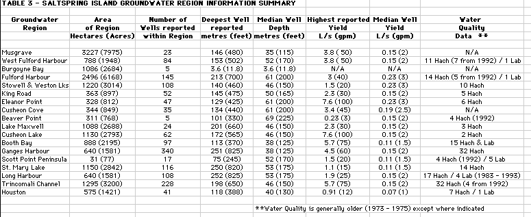