|
|
Gathering
Information and Data
Information gathering is a critical phase
of any project. Table 4 below shows the types of information that
can be useful to your project, and the sections below discuss steps
to gather the information that you will need. The more information
gathered the better your chances for a successful project. It's
important to consult as many sources, experts, and groups as possible.
Table 4. Planning Your Restoration Project –
Types of Information
(adapted from Stewardship Series: Community
Stewardship: A Guide to Establishing Your Own Group)
| Types of Information
|
| Biophysical
|
Social/Cultural/Economic
|
Organization/Strategic
|
Ecosystem Classification
(e.g. biogeoclimatic zone)
Geology, topography
Soils
Climate
Groundwater
Surface water
Watershed boundaries
Vegetation, forest resources
Wildlife, Fish
Current Condition of above features (e.g. level of degradation,
number of endangered species, levels and types of pollution)
|
History: cultural heritage,
past settlement, resource land use
First Nations traditional territories
Current cultural groups in the community
Land tenures
Current land uses and values:
recreation, spiritual, resource production (forestry, mining,
agriculture, fisheries) urban (residential, industrial, institutional)
Economic values of the above uses
Existing and proposed land use plans |
Other groups in the area
and relevant provincial-level or umbrella groups
Government agencies with planning, resource management, and
conservation responsibilities and the policies and statutes
they apply
Governments having jurisdiction over the area, political boundaries,
and the timing of up-coming elections
Community organizations and volunteer pools
Possible research support:
educational institutions, libraries, consultants
Recent and current resource and conservation issues and solutions
|
These
information-gathering steps are presented chronologically but may
take place in a different order, or simultaneously:
1. Identify Ecosystem Classification
The provincial Biogeoclimatic Ecosystem Classification (BEC) system
provides a basis for understanding the type of ecosystem you are
working with. The BEC system integrates climate, geology, and vegetation
to provide an understanding of the native plant communities appropriate
for a site. Therefore, it is important to identify which BEC subzone
and site series your target area falls into (see the Resources
Section for BEC resources; you may also be able to obtain or
view a large-scale BEC map of your area at your local Ministry of
Forests office). You should also know which Natural
Disturbance Type describes your site (see 'The
Importance of Natural Disturbance Processes'), as the natural
disturbance regime will also affect the types of ecosystems naturally
present. The Biodiversity
Guidebook provides a list of which BEC subzones belong to which
Natural Disturbance Type.
2. Accumulate
and Review Current Maps, Reports, Plans, and Aerial Photographs
Restoration planning always involves collecting relevant, project-specific
information. Resources like maps, reports, plans, and aerial photographs
are generally available through key players, such as government
agencies. Your local Ministry
of Forests office will have access to some of these resources
if your site is on Crown forest or range land, and if your site
is an aquatic feature your regional Ministry
of Environment office or Fisheries
and Oceans Canada office may have relevant reports or data.
The Ministry of Sustainable
Resource Management is the repository of inventories and
maps. A great deal of information can be found on the web (see
below).
If your site is on Crown forest land, the local forest industry
contact may have the best and most up-to-date aerial photographs
and maps, and will be able to provide information on logging, road
plans, and other pertinent details.
Dave Polster
Soils maps can be used to determine soil conditions
in the project area, though more investigation is needed to determine
exact conditions of the restoration site.
The following is a list of common types of
information to gather for your project, and where this information
is found:
- Vegetation information. This
is available in the Biogeoclimatic (BEC) handbooks and online
BEC
information (please see Resources
section). Vegetation information is also available through
Forest Cover Maps, BEC maps, and Terrestrial Ecosystem Maps (see
next). Some areas of the province have more detailed vegetation
studies and you should check with your local Ministry of Environment,
or Ministry of Sustainable Resource Management
office.
- Maps. The types of maps you may
need (as available) are:
- Terrain Resources Information Maps
(TRIM). These maps are available at a 1:20,000 scale
in paper copies or digital for the whole province, and can form
a good base map for your project. Paper copies are available
from your local Government
Agent , or from Land
Data BC (see Resources
section).
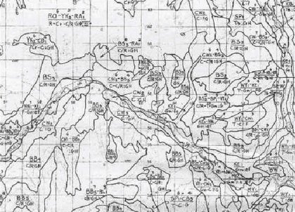
- Biogeoclimatic Ecosystem Classification
(BEC) Regional Maps. These are available through your
local or regional Ministry of Forests office, or Ministry of
Sustainable Resource Management office. These maps are at a
1:250,000 scale, and show the BEC subzones for your region.
- Forest Cover Maps are available
for all Crown forests at a 1:20,000 (stand
level) scale, and describe and map the distribution
of the dominant tree species and age classes. These maps are
very useful for restoration planning; paper copies may be obtained
from Clover
Point Cartographics in Victoria, BC, phone number: (250)
384-3537. Digital
copies are available from the Ministry of Sustainable Resource Management.
- Terrestrial Ecosystem Maps (TEM)
are very useful if available, as they contain information on
vegetation and soils at a 1:20,000 scale. Predictive
Ecosystem Mapping (PEM) is also done for parts of the
Province and similarly provides predictions of vegetation and
soils types at 1:20,000 scale. The Ministry of Sustainable Resource
Management is a contact for this mapping.
- NTS Topographic Maps. These
are produced by the federal government at a 1:50,000 scale for
all of Canada. The 1:50,000 scale is a useful scale for project
planning in larger areas. Ordering information is available
from Natural
Resources Canada. These maps can also be purchased at various
commercial outlets, and through Crown
Publications.
- Soils and Geology Maps, where
available, can provide good information about site characteristics
and capabilities. Landform and geologic information can be useful
in project planning. The Geological
Survey of Canada is one source for this type of information.
- Grassland Maps are recently
available from The Grassland
Conservation Council of British Columbia (see Resources
section) for the Southern Interior, and grassland maps and
information will be available for the entire province.
- Links to other
maps, and advice on finding maps and air photos,
is available through Base
Mapping and Geomatic Services Branch. Many map products
and air photos from this branch are distributed through Landdata
BC.
- Aerial
Photographs. Aerial photographs are an important resource
for project planning and can also be important for project mapping.
Examining older air photos and comparing with more recent ones
can show changes over time, and may show the site in less degraded
condition. More recent photos give the best overview of a site.
Black & white or color air photos are available for most of
the province through Private
Air Photo Agents, Government
Agents, and Landdata
BC, or can be borrowed in person at the Air
Photo Library (810 Blanshard Street, Victoria). The oldest
air photos are usually from the 1950’s and are black & white,
with color photo coverage beginning in the 1970’s. Natural Resources
Canada has its own Air Photo Library, for all of Canada (see their
Air
Photo 101). Not all air photos are catalogued this with the
Provincial and Federal governments, and it is worth asking other
agencies or corporations (e.g. BC Hydro, forestry companies) and
local government staff if they have air photo coverage of your
site. For large projects it is sometimes worthwhile to take aerial
photos for planning purposes.
- Aquatic Information.
Information and various map products related to fish are available
through FishInfo
BC (http://www.bcfisheries.gov.bc.ca/fishinv/fishinfobc.html),
from the Ministry of Sustainable Resource Management:
-
FishWizard can be used to create a map and find fisheries
information about your site.
- The
Fisheries Project Registry is a database of current and
past fisheries inventories, assessments, restoration and enhancement
projects, and research.
- The
Fisheries Information Summary System (FISS) provides fish
and fish habitat information and lists of reports for BC and
the Yukon, displayed on 1:50,000 scale maps using the Watershed
Atlas.
- Aquatic
Biophysical Maps (1:50,000 scale) can be bought from Crown
Publications, and show information on physical channel and
valley characteristics, substrate (bed) materials, aquatic and
bank vegetation, hydraulics and fish species presence and life
history. Watershed boundaries are also delineated on the maps.
- Watershed-Based
Fish Sustainability Planning is a coordinated agency and
stakeholder effort that will make aquatic restoration needs
available. Information from this planning process should be
consulted as it becomes available.
- Rare and Endangered Species and Ecosystems.
A web
site from The Ministry of Environment gives
information on species and ecosystems at risk in British Columbia,
and provides a link to 37 brochures on species and ecosystems
at risk. You should check with the Conservation
Data Centre (CDC) (see Resources
section) for an 'Element Occurrence Report' of rare and
endangered species or plant associations potentially present
in your area.
Requests for these reports can be made over the web. It is important
to know that many organisms have regional or local significance
and are not listed by the CDC or others as rare or endangered;
these species may become important within the framework of
your
project. These organisms can be identified and assessed with
the help of local natural history groups and biologists. significance
and are not listed by the CDC or others as rare or endangered;
these species may become important within the framework of
your
project. These organisms can be identified and assessed with
the help of local natural history groups and biologists.
- Existing Inventories, Assessments or
Reports. There are usually data on a site that are essential
to consider in making informed decisions. Key
players can make this information known, and, for aquatic
systems, some information is available on the web (see above).
Examples of other sources are:
- Historical Information. Local
archives or museums may have useful information. Additionally,
old air photos (see above) will provide excellent
information on former site conditions. Resource agencies and other
key players will sometimes have files with old information and
reports.
- Existing Assessment
Procedures and Best Management Practices. In some cases,
guidance may be found in government-generated, standardized methods
of collecting information. The major sources of these standards
are the Resources
Inventory Standards Committee (RISC), and the various Watershed
Restoration Program (WRP) technical
circulars available from the Ministry of Sustainable Resource
Management. A Riparian Best Management Practices manual is available
from the Ministry
of Forests, and the Stewardship
Centre offers technical suggestions and case studies, particularly
for aquatic ecosystems (see Resources Section for contact information
for these standards and information sources).
3. Do a Search for Archival
Materials or Research on the Site
Gathering historical information, such as air photos and photos from
local archives, and research will be important for understanding the
history of the site.
4. Review Historic and Current
Land Use
An understanding of the past and current land
uses will help make clear the sources of impact to the site, and assist
in delimiting restoration possibilities and constraints. Resource
agencies, resource users, First Nations, and local residents can provide
information on land uses (see 'Key Players',
and 'Determining Land Ownership and Tenures').
For historic land uses, sources of information are various (see 'Using
Historical Reference Conditions as Templates').
5. Become Familiar with Similar
Restoration Projects
Though no two projects are alike, significant
savings in time, money, and effort can still be realized by learning
from those with experience in similar situations. Interviews with
project proponents, reviewing their reports, and/or arranging site
visits will help to capitalize on the efforts of others. Through this
type of networking, practical concerns can be identified and addressed
in the planning stages.
6. Survey Your Site & Create
a Map
By this stage you will already know a great
deal about your site, but more detailed data is usually necessary
in order to develop good restoration prescriptions. You should start
by using collected maps, air photos, site reconnaissance, and other
information to understand the site characteristics. An on-the-ground
survey should be undertaken to refine this information, and provide
enough information for quantifying restoration needs and mapping restoration
zones. It may be necessary to bring in specialists for this phase
(see Resources section).
Suggestions for data collection or observation include:
Collecting
Site Information
- Hydrology
(current and previous). Aquatic and hydrological features should
be noted and located on a map, and the previous hydrology noted
if apparent. Hiring a professional hydrologist may be useful where
sites are complicated; the distribution of water on a site will
have great bearing on diversity and types of vegetation present
and possible. The condition of aquatic features can be described
using various assessment procedures (see above).
- Vegetation Polygons. Areas of
similar vegetation types should be located and their extent mapped.
Often the site survey will be done to confirm and refine vegetation
information described in maps, air photos and previous reports.
In general, descriptions based on the dominant species for each
main type of vegetation (trees, shrubs, forbs, grasses, or bryophytes)
are sufficient for restoration purposes. Rare species or communities,
and concentrations of invasive species should be noted. The key
is to define similar enough units that consistent restoration
treatments can be prescribed for similar vegetation polygons.
For these vegetation assessments it is often prudent to seek the
advice of an experienced biologist or forester.
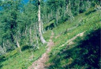
- Wildlife use. Important animal
trails or nesting or denning sites might become obvious during
your site assessment. These should be noted to ensure that restoration
activities preserve important habitats.
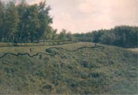
Dave Polster |
Dave Polster |
| Mapping the vegetation of the project
site is critical for planning what restoration needs to take
place where. This photo shows the delineation of vegetation
polygons into two distinct types. |
Wildlife use: this well-used elk trail
should be preserved as part of restoration efforts in this fire-suppressed
sub-alpine forest. |
- Previous land use and condition.
Observing clues of previous land uses and previous site conditions
can be helpful in understanding the impacts on your site. Clues
of previous land use might include old railway grades, old roads,
and farmsteads, as well as overgrown dykes. Previous land condition
may also be apparent from observations such as stump counts (i.e.,
former size, distribution and species of trees, or types of trees
selectively logged) and remnant fragments of the former ecosystem.
- Soils. If site has been changed
radically, as is common in agricultural or urban areas, an examination
of the soils may give clues about the previous ecosystem. For
example, digging a soil pit might reveal the peat of a former
bog, or the rich black soils of a former Garry oak meadow.
- Access and other infrastructure.
Good road or trail access can make a difference to a restoration
project. Points of access and other infrastructure should be noted
for inclusion in the site map.
A detailed map should be created based on the information collected.
TRIM maps or air photos often provide a base for a site map (see above).
Vegetation polygons, aquatic features, and infrastructure should be
noted.
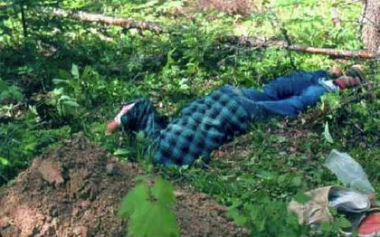
Dave Polster
A careful inspection of the soils of the site
can reveal information about the nature and history of the site.
|