|
(published
1998)
Habitat Atlas
for Wildlife at Risk
What Makes the Okanagan a Special Area?
 The
South Okanagan and Lower Similkameen has long been recognized
as a region that combines a tremendous diversity of
habitats with unique species, many of which are found
nowhere else in the province or in Canada. The Okanagan
Valley also has more species of plants and animals living
here than in most areas of both British Columbia and
Canada. But it is now one of the four most endangered
ecosystems in our country. The unique characters of
this ecosystem are centred on the low elevation grasslands
and dry forests, habitats most threatened by agricultural
and urban developments. The
South Okanagan and Lower Similkameen has long been recognized
as a region that combines a tremendous diversity of
habitats with unique species, many of which are found
nowhere else in the province or in Canada. The Okanagan
Valley also has more species of plants and animals living
here than in most areas of both British Columbia and
Canada. But it is now one of the four most endangered
ecosystems in our country. The unique characters of
this ecosystem are centred on the low elevation grasslands
and dry forests, habitats most threatened by agricultural
and urban developments.
The low elevation grasslands cover about
one quarter of the South Okanagan landscape, but 81
percent of the agricultural and urban developments have
taken place here. These developments have altered more
than 60 percent of the grasslands and shrub habitats
of this zone, and only 9 percent are in a relatively
undisturbed state. An estimate 85 percent of wetland
and stream-side habitats have been lost.
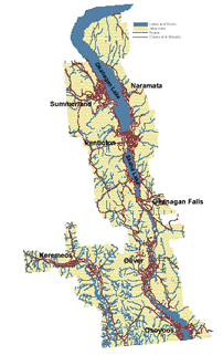
The South Okanagan and Lower Similkameen Atlas
Area
The South Okanagan ecosystem area covered by this
atlas extends over a land area of approximately 159,000
hectares from Naramata and Summerland south to the United
States border and east to Keremeos.
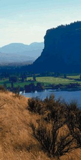
The southern end of the Okanagan Valley in Canada represents
the northernmost extension of the Western Great Basin
of North America. Low annual precipitation, hot summers,
and mild winters create a variety of semi-arid habitats.
The dry grasslands and open pine forests of the Okanagan
have served as a vital landscape corridor between the
shrub-steppe habitats of the Columbia Basin in Washington
and Oregon and the grasslands of the Thompson and Nicola
valleys to the north and west.
The area lies within the Southern Interior Ecoprovince,
the only ecoprovince in British Columbia that is part
of the Dry Ecodomain and Semi-arid Steppe Highland Ecodivision.
Biodiversity
 The
Okanagan Valley lies like the neck of an hourglass between
the vast boreal forests to the north and the Great Basin
deserts to the south. This critical position, when combined
with the altitudinal range in the valley, the chain
of large lakes, and the flow of moist air off the Pacific
at high elevations, produces an abundance of animal
and plant species found in few other places in Canada
or even North America. The
Okanagan Valley lies like the neck of an hourglass between
the vast boreal forests to the north and the Great Basin
deserts to the south. This critical position, when combined
with the altitudinal range in the valley, the chain
of large lakes, and the flow of moist air off the Pacific
at high elevations, produces an abundance of animal
and plant species found in few other places in Canada
or even North America.
Desert-like grasslands in the valley bottom are bordered
on one side by rich marshes and moist cottonwood and
birch woodlands, on the other by towering cliffs and
hillsides covered with ponderosa pine forests. As you
move upward, these forests change to Douglas-fir, larch,
lodgepole pine, spruce and subalpine fir, and finally
to alpine tundra.
Many species reach their southern or northern limits
in the Okanagan. Populations at the end of their species'
ranges are usually genetically diverse, since they are
meeting greater challenges in habitat, climate and competitors.
This genetic diversity is very important to the overall
health of species' populations, and is critical to their
survival in times of environmental change; it is also
an integral part of the biodiversity of the South Okanagan.
 Thus,
the South Okanagan has long been recognized as a site
that combined a tremendous diversity of life with an
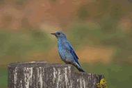
impressive list of species. About 190 species of birds
breed in the South Okanagan. Not only is this almost
half the Canadian total, but it is probably the highest
total for any area of similar size in Canada, and close
to the highest in United States and Canada. Thus,
the South Okanagan has long been recognized as a site
that combined a tremendous diversity of life with an
impressive list of species. About 190 species of birds
breed in the South Okanagan. Not only is this almost
half the Canadian total, but it is probably the highest
total for any area of similar size in Canada, and close
to the highest in United States and Canada.

|