The Thompson region is one of the most biophysically diverse regions in the province. Ecosystems range from the coastal transition
zone in the western part of the region (west Fraser) through the interior dry grasslands to the interior temperate rainforest.
Ecoregions of British Columbia
| * click on images to enlarge |
Ecoprovinces |
|
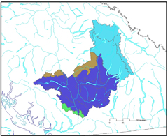 |
Ecoregions |
|
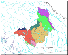 |
Ecosections |
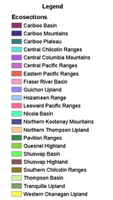 |
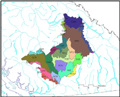 |
The Cariboo Basin Ecosection is a rolling upland with dry forests, interspersed with wetlands and
grasslands on south facing slopes.
The Cariboo Plateau Ecosection is an upland area with increased moisture and moderate temperatures
in the southeast. The Cariboo Plateau Ecosection is an upland area with increased moisture and moderate temperatures in the southeast.
The Cariboo Mountains Ecosection is an area of high rugged, ice-capped mountains with narrow valleys.
It lies at the north end of this ecoregion.
The Central Chilcotin Ranges Ecosection is a dry, rounded mountain area located leeward of the Pacific
Ranges in the Southeast.
The Central Columbia Mountains Ecosection is an area of high ridges and mountains, but the valleys and
trenches are narrow. Precipitation is high, from the valley bottoms to the upper slopes.
The Eastern Pacific Ranges Ecosection is a rugged inland area that has transitional climates including
some rain shadow. It lies west of the Southern Interior Ecoprovince.
The Fraser River Basin Ecosection is the dissected portion of the Chilcotin and Cariboo plateaus and the
Fraser 'badlands' that lies between them. It has the warmest and driest climate in the Ecoregion.
The Hozameen Range Ecosection lies on the east side of the Cascade Ranges' divide. It is mountainous and
increases with ruggedness from north to south.
The Leeward Pacific Ranges Ecosection has bold mountains with deep, narrow valleys in the north.
While in the south the mountains become subdued.
The Northern Kootenay Mountains Ecosection is an area of high, rugged mountains, many of which are ice-capped.
It has the highest precipitation and coldest temperatures.
The Northern Thompson Upland Ecosection is an area with dissected uplands. The climate is transitional
between the drier and warmer climates farther south and moister and cooler climates to the north. It has warm, dry summers and mild winters with
relatively high snowfall.
The Pavilion Ranges Ecosection is a mountainous upland area that is transitional with the Coast Ranges to the
west and the plateau surface to the east. The Fraser and Thompson rivers have dissected the upland surface. The Bunchgrass and Ponderosa Pine
Zones predominate the lower mountain slopes upland surface.
The Quesnel Highland Ecosection is a highland area, intermediate between the plateaus to the west and the high,
rugged mountains to the east. Precipitation is higher here than in the Shuswap Highland Ecosection to the south.
The Shuswap Highland Ecosection is a highland area, intermediate between the plateaus to the west and the
mountains to the east. The climate here is warmer and winters are milder than the Quesnel Highland Ecosection to the north.
The Southern Chilcotin Ranges Ecosection has high rounded mountains, with deep narrow valleys.
Dry forests in the Alpine Tundra Zone are extensive.
The Thompson Basin Ecosection is a warm and exceptionally dry, low elevation area with a high diversity and
abundance of wildlife.
Biogeoclimatic Ecosystem Classification (BEC) web
Ecoprovinces |
 |
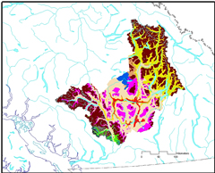 |
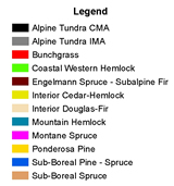
Below are the BEC zones of the Thompson Region:
Bunchgrass (BG)
Ponderosa Pine (PP)
Interior Douglas Fir (IDF)
Interior Cedar Hemlock (ICH)
Engelmann Spruce - Subalpine Fir (ESSF)
Sub-boreal Pine Spruce (SBPS)
Montane Spruce (MS)
Sub-boreal Spruce (SBS)
Alpine Tundra (AT)
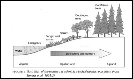
Reference:
Stevens, V., F. Backhouse, and A. Eriksson. 1995. Riparian Management in British Columbia: an important
step towards maintaining biodiversity. B.C. Min. For. And B.C. Min. Environ., Lands and Parks, Victoria, B.C. Work. Pap. 13/ 1995.
|