Contents
- Fish and Wildlife
- &

Certificate of Insurance:
Visit our RSS Feeds page to subscribe to receive instant notifications of hunting news updates, and to see a complete list of RSS feeds that we offer. You can also click on the RSS icon (
) above to quickly subscribe to this feed.
Date News Article and Link
April 18, 2016 Attention Hunters and Licence Vendors – Amendment
The Fall 2016 LEH Draw will open for submissions on April 25.
Effective April 25, Hunters can apply online, or at Service BC, FrontCounter BC, or participating licence vendors.
Until then, it is business as usual for anyone wishing to obtain a Hunter Number or purchase a hunting licence. Hunters can obtain their Fish and Wildlife ID when they apply for LEH – either online or at a service provider. You will need a Basic BCeID to access the new BC Hunting online system on April 25. Registration for a Basic BCeID is quick and easy. You can also use a Personal BCeID, if you choose; this is obtainable online but requires in-person verification.
Continue to monitor www.gov.bc.ca/hunting for more updates.
April 18, 2016 The 2016/2017 Limited Entry Hunting Synopsis is online
The 2016/2017 Limited Entry Hunting Synopsis is online at http://www.env.gov.bc.ca/fw/wildlife/hunting/resident/leh.html#Synopsis. Hard copies are currently being distributed throughout the province.
The Fall 2016 LEH Draw will open for submissions on April 25. Effective April 25, Hunters can apply online, or at Service BC, FrontCounter BC, or participating licence vendors.
April 12, 2016 Attention Hunters and Licence Vendors – Amendment
The Fall 2016 LEH Draw will open for submissions on April 25.
Effective April 25, Hunters can apply online, or at Service BC, FrontCounter BC, or participating licence vendors.
Until then, it is business as usual for anyone wishing to obtain a Hunter Number or purchase a hunting licence. Hunters can obtain their Fish and Wildlife ID when they apply for LEH – either online or at a service provider.
Continue to monitor www.gov.bc.ca/hunting for more updates.
April 8, 2016 Attention Hunters and Licence Vendors
The Fall 2016 LEH Draw will open for submissions on April 25.
Effective April 25, Hunters can apply online, or at Service BC, FrontCounter BC, or participating licence vendors.
Until then, it is business as usual for anyone wishing to obtain a Hunter Number or purchase a hunting licence.
Continue to monitor www.gov.bc.ca/hunting for more updates.
March 24, 2016 Attention Hunters and Licence Vendors
The new BC Hunting online system will be available by the end of April. Until then, it is business as usual for anyone wishing to obtain a Hunter Number or purchase a hunting licence.
The Fall 2016 LEH Draw will open for applications when the BC Hunting online service is up and running.
Continue to monitor www.gov.bc.ca/hunting for more updates.
March 3, 2016 Hunting Services Going Online!
In April 2016, the Province will introduce a new online system that will improve the overall efficiency of hunter services. Initially the online service will be for Limited Entry Hunting (LEH) applications.
The BC Hunting online system will give you instant access to a range of products and services. In April, hunters will be able to apply online for Limited Entry Hunting (LEH). The draws will follow the same rules as before, but you’ll be able to apply from home, any time of day, and track your application(s) in real time.
In the future, the system will integrate a range of online services for hunters, including licensing.
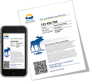
Your Fish and Wildlife ID (FWID)
To get started in April, you’ll need a FWID to apply for LEH or to buy a hunting licence. The FWID is a permanent number linked to your personal online profile, and will be your passport to hunting services.
The FWID replaces the old BC Hunter Number card. If you already have a BC Resident Hunter Number, your new FWID will be the same number, with three extra digits.
It’s easy to get your FWID. Come April, just go online and follow the simple registration process. Whether you’re a first-time hunter or already have a Hunter Number, the system will automatically generate your new FWID.
There is no cost to get your FWID.
Don’t want to use the online service?
Just drop into any Service BC or FrontCounter BC location or call the FrontCounter BC Contact Centre at 1-877-855-3222.
Watch for these new services coming online in April.
Changes to the LEH Applications
The Province is no longer selling paper application cards for the LEH draw. If you previously purchased a paper application card, you can use it for the fall 2016 draw, or submit the unused card for a refund.
To request a refund for unused LEH application cards, fill out the return address section on the back of the unused application card and print “Refund” across the front. If you are submitting more than one card, include all of them in one envelope. Requests must be postmarked no later than December 31, 2016, and mailed to:
LEH Refund
Fish and Wildlife Branch
2975 Jutland Road
PO Box 9389 Stn Prov Govt
Victoria BC V8W 9M7Note: Be sure to print clearly. Refund requests with incomplete or illegible names and/or addresses will not be processed. Please make sure the Return Address area on the back of the application card has your first and last name, Hunter Number or FWID (if available) and your complete mailing address.
If you are submitting more than one LEH application card for a refund, you can include all of them in one envelope. Please ensure that one of the application cards is correctly filled out as described in Steps 1 and 2 above. Only one refund cheque per envelope will be issued. Do not submit more than one Hunter Number and name in an envelope.
For more information about the new online service and changes to the LEH application process:
- Call FrontCounter BC at 1-877-855-3222
- Email HuntingTransformation@gov.bc.ca
- Frequently Asked Questions
Dec. 10, 2015 Notice to Hunters - Changes are coming to Hunter Registration and the Limited Entry Hunting (LEH) Draw.
The Province will introduce a new online system for hunters in 2016, making it easier for you to register and apply for Limited Entry Hunting (LEH) draws. You can submit LEH applications online at home, or at a Service BC, FrontCounter BC, or vendor location. The online service will be available for the Fall 2016 LEH Draw. More information will be provided in the 2016-2017 Limited Entry Hunting Regulations Synopsis.You can no longer purchase paper application forms for the Fall 2016 LEH Draw or the 2016 Special Sheep LEH Draw. Application forms for the Spring 2016 LEH Draw can be purchased only at the following locations:
- All Service BC locations during regular business hours, Monday to Friday, 8:30 am to 4:30 pm. Note: You do not need a hunter number or license to purchase an application form.
- Italian Sporting Goods, 804 Renfrew Street, Vancouver
- Reliable Gun & Tackle, 3227 Fraser Street, Vancouver
- International Shooting Supplies, 14904 104th Avenue, Surrey
- Wholesale Sports, 20175 Langley Bypass, Langley
- Belles Sports, 33089 First Avenue, Mission
If you have already purchased application forms, you can use them for the Spring 2016 or Fall 2016 LEH Draw. After the Fall 2016 LEH Draw, paper application forms will NOT be accepted. For more information, see the frequently asked questions. You can also email the Fish and Wildlife Branch at HuntingTransformation@gov.bc.ca, or call 1-877-855-3222.
May 28, 2015 Notice to Hunters – The Limited Entry Hunt for Roosevelt Elk in Zone A of Management Unit 1-07 (in the vicinity of Port Alberni, on the south side of Sproat Lake), HUNT CODE 2040, Season Date October 10 – November 20, Bull Only underwent review and is now closed. Inventory surveys conducted on March 31, 2015 indicate that the population of this herd is in decline and may not be able to sustain a harvest. Individuals that have already applied for this hunt may contact Limited Entry Hunting staff at (250) 356-5142 and have their LEH application card changed. Note that this offer to change LEH application cards by phone is only available for this hunt (hunt code 2040) and only available up to 4:30, June 10th. March 20, 2015 The 2015-2016 Limited Entry Hunting Synopsis is now available on-line. Hard copies (printed version) are currently being printed and should be available at your local vendor the week of Apri 6, 2015.
Please note: The application deadline is May 22, 2015.
November 26, 2014 Wildlife staff in the Kootenay Region are currently updating the regional Elk Management Plan for 2015-19. This plan will review and revise current elk management objectives, and identify actions to address key issues in the region.
To better understand the interests, experiences and opinions of First Nations, elk hunters, agricultural producers and the general public, we are conducting an on-line survey. Click here to participate in the survey by December 22, 2014. The results of this survey will be summarized in a publically available report, and used to develop the 2015-19 elk management plan.
We encourage you to briefly review or have available the following background information to facilitate survey completion:
2010-14 Kootenay Elk Management Plan [PDF 912KB]
Kootenay Elk Population Review [PDF 1.87MB]
Allow approximately 15-20 minutes to fill out this questionnaire. This questionnaire can only be filled in once per person.
May 9, 2014 The 2014-2016 Hunting and Trapping Regulations Synopsis, effective July 1, 2014 to June 30, 2016, is now available on-line. Hard copies (printed version) are currently being printed and should be available at your local vendor within the next couple of weeks.
October 8, 2013 Looking for a Map for your LEH Zone hunt? Click here for all LEH Zone maps. Feb 16, 2013 Wildlife Act amendments grow hunter recruitment through an expanded youth licence and a new initiation hunting licence, both of which will be effective for the 2013/14 hunting season. For more information click here.